|
|
|
- Caroline Merryl Stanley
- 5 years ago
- Views:
Transcription
1
2
3
4
5
6
7
8
9
10
11

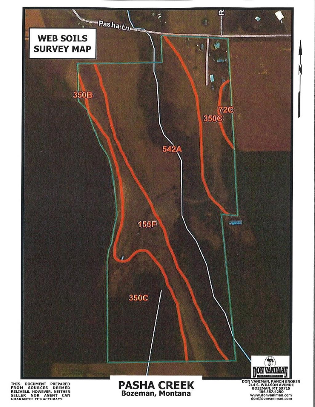
12 72C 155F 350B 350C 542A SOILS IN AREA OF INTEREST Doughty Loam; 4 to 8 percent slopes Anceney Cobbly Loam; 15 to 60 percent slopes Blackmore Silt Loam; 0 to 4 percent slopes Blackmore Silt Loam; 4 to 8 percent slopes Blossberg Loam; 0 to 2 percent slopes Soil Survey Area: Gallatin County Area, Montana Survey Area Data: Version 22, Sep 5, C Doughty Loam, 4% - 8% slopes Map Unit Setting National map unit symbol: 5709 Elevation: 5,000 to 5,650 feet Mean annual precipitation: 18 to 22 inches Mean annual air temperature: 37 to 43 degrees F Frost-free period: 80 to 95 days Farmland classification: Farmland of statewide importance Map Unit Composition Doughty and similar soils: 90 percent Minor components: 10 percent Estimates are based on observations, descriptions, and transects of the mapunit. Description of Doughty Setting Landform: Alluvial fans, stream terraces Parent material: Loamy alluvium Typical profile A - 0 to 8 inches: loam Bt - 8 to 15 inches: gravelly clay loam Bk - 15 to 21 inches: gravelly loam 2Ck - 21 to 60 inches: very gravelly loam Properties and qualities Slope: 4 to 8 percent Depth to restrictive feature: More than 80 inches Natural drainage class: Well drained Capacity of the most limiting layer to transmit water (Ksat): Moderately high to high (0.20 to 1.98 in/hr) Depth to water table: More than 80 inches Frequency of flooding: None Frequency of ponding: None Calcium carbonate, maximum in profile: 40 percent Salinity, maximum in profile: Nonsaline to very slightly saline (0.0 to 2.0 mmhos/cm) Available water storage in profile: Low (about 5.9 inches) Interpretive groups Land capability classification (irrigated): 4e Land capability classification (nonirrigated): 4e Hydrologic Soil Group: B Ecological site: Silty (Si) 20"+ p.z. (R043BS323MT), Upland Shrubland (R044BP820MT) Map Unit Description: Doughty loam, 4 to 8 percent slopes Minor Components Doughty Percent of map unit: 5 percent Landform: Alluvial fans, stream terraces Ecological site: Silty (Si) 20"+ p.z. (R043BS323MT) Anceney Percent of map unit: 3 percent Landform: Stream terraces Ecological site: Silty-Droughty (SiDr) 15-19" p.z. (R044XS690MT) Doughty Percent of map unit: 2 percent Landform: Stream terraces, alluvial fans Ecological site: Silty (Si) 20"+ p.z. (R043BS323MT)
13 155F Anceney Cobbly Loam, 15% - 60% slopes Map Unit Setting National map unit symbol: 56lq Elevation: 4,500 to 5,900 feet Mean annual precipitation: 15 to 19 inches Mean annual air temperature: 37 to 45 degrees F Frost-free period: 90 to 110 days Farmland classification: Not prime farmland Map Unit Composition Anceney and similar soils: 90 percent Minor components: 10 percent Estimates are based on observations, descriptions, and transects of the mapunit. Description of Anceney Setting Landform: Escarpments Parent material: Loamy alluvium colluvium Typical profile A - 0 to 6 inches: cobbly loam AB - 6 to 10 inches: gravelly loam Bk - 10 to 60 inches: very cobbly loam Properties and qualities Slope: 15 to 60 percent Depth to restrictive feature: More than 80 inches Natural drainage class: Well drained Capacity of the most limiting layer to transmit water (Ksat): Moderately high to high (0.57 to 1.98 in/hr) Depth to water table: More than 80 inches Frequency of flooding: None Frequency of ponding: None Calcium carbonate, maximum in profile: 30 percent Salinity, maximum in profile: Nonsaline to very slightly saline (0.0 to 2.0 mmhos/cm) Available water storage in profile: Low (about 5.2 inches) Interpretive groups Land capability classification (irrigated): None specified Land capability classification (nonirrigated): 7e Hydrologic Soil Group: B Ecological site: Silty-Droughty-Steep (SiDrStp) 15-19" p.z. (R044XS356MT), Upland Grassland (R044BP818MT), Upland Sagebrush Shrubland (R043BP819MT) Minor Components Meagher Percent of map unit: 5 percent Landform: Escarpments Ecological site: Thin Silty (TSi) 15-19" p.z. (R044XS363MT) Bowery Percent of map unit: 3 percent Landform: Escarpments Ecological site: Overflow (Ov) 15-19" p.z. (R044XS351MT) Cabba Percent of map unit: 2 percent Landform: Escarpments Ecological site: Shallow (Sw) 15-19" p.z. (R044XS353MT) 350B Blackmore Silt Loam, 0% - 4% slopes Map Unit Setting National map unit symbol: 56q7 Elevation: 4,850 to 5,550 feet Mean annual precipitation: 18 to 22 inches Mean annual air temperature: 37 to 43 degrees F Frost-free period: 80 to 95 days Farmland classification: All areas are prime farmland Map Unit Composition Blackmore and similar soils: 90 percent Minor components: 10 percent Estimates are based on observations, descriptions, and transects of the mapunit. Description of Blackmore Setting Landform: Stream terraces Parent material: Calcareous loess Typical profile A - 0 to 10 inches: silt loam Bt - 10 to 27 inches: silty clay loam Bk1-27 to 42 inches: silt loam Bk2-42 to 60 inches: silt loam Properties and qualities Slope: 0 to 4 percent Depth to restrictive feature: More than 80 inches Natural drainage class: Well drained Capacity of the most limiting layer to transmit water (Ksat): Moderately high (0.20 to 0.57 in/hr) Depth to water table: More than 80 inches Frequency of flooding: None Frequency of ponding: None Calcium carbonate, maximum in profile: 30 percent Available water storage in profile: High (about 11.4 inches) Interpretive groups Land capability classification (irrigated): 4e Land capability classification (nonirrigated): 4e Hydrologic Soil Group: C Ecological site: Silty (Si) 20"+ p.z. (R043BS323MT), Upland Grassland (R044BP818MT) Minor Components Bowery Percent of map unit: 5 percent Landform: Stream terraces, alluvial fans Ecological site: Silty (Si) 15-19" p.z. (R044XS355MT) Blackmore Percent of map unit: 3 percent Landform: Stream terraces Ecological site: Silty (Si) 20"+ p.z. (R043BS323MT) Brodyk Percent of map unit: 2 percent Landform: Stream terraces Ecological site: Limy (Ly) 15-19" p.z. (R044XS357MT)
14 350C Blackmore Silt Loam, 4% - 8% slopes Map Unit Setting National map unit symbol: 56q8 Elevation: 4,750 to 5,600 feet Mean annual precipitation: 18 to 22 inches Mean annual air temperature: 37 to 43 degrees F Frost-free period: 80 to 95 days Farmland classification: Farmland of statewide importance Map Unit Composition Blackmore and similar soils: 90 percent Minor components: 10 percent Estimates are based on observations, descriptions, and transects of the mapunit. Description of Blackmore Setting Landform: Stream terraces Parent material: Calcareous loess Typical profile A - 0 to 10 inches: silt loam Bt - 10 to 27 inches: silty clay loam Bk1-27 to 42 inches: silt loam Bk2-42 to 60 inches: silt loam Properties and qualities Slope: 4 to 8 percent Depth to restrictive feature: More than 80 inches Natural drainage class: Well drained Capacity of the most limiting layer to transmit water (Ksat): Moderately high (0.20 to 0.57 in/hr) Depth to water table: More than 80 inches Frequency of flooding: None Frequency of ponding: None Calcium carbonate, maximum in profile: 30 percent Available water storage in profile: High (about 11.4 inches) Interpretive groups Land capability classification (irrigated): 4e Land capability classification (nonirrigated): 4e Hydrologic Soil Group: C Ecological site: Silty (Si) 20"+ p.z. (R043BS323MT), Upland Grassland (R044BP818MT) Minor Components Bowery Percent of map unit: 4 percent Landform: Alluvial fans, stream terraces Ecological site: Silty (Si) 15-19" p.z. (R044XS355MT) Hydric soil rating: Unranked Brodyk Percent of map unit: 3 percent Landform: Stream terraces Ecological site: Limy (Ly) 15-19" p.z. (R044XS357MT) Hydric soil rating: Unranked Doughty Percent of map unit: 3 percent Landform: Stream terraces Ecological site: Silty (Si) 20"+ p.z. (R043BS323MT) Hydric soil rating: Unranked 542A Blossberg Loam, 0% - 2% slopes Map Unit Setting National map unit symbol: 56wx Elevation: 4,200 to 5,550 feet Mean annual precipitation: 12 to 18 inches Mean annual air temperature: 39 to 45 degrees F Frost-free period: 90 to 110 days Farmland classification: Farmland of local importance Map Unit Composition Blossberg and similar soils: 85 percent Minor components: 15 percent Estimates are based on observations, descriptions, and transects of the mapunit. Description of Blossberg Setting Landform: Stream terraces Parent material: Alluvium Typical profile A - 0 to 15 inches: loam Bg - 15 to 24 inches: sandy clay loam 2C - 24 to 60 inches: extremely gravelly loamy coarse sand Properties and qualities Slope: 0 to 2 percent Depth to restrictive feature: More than 80 inches Natural drainage class: Poorly drained Capacity of the most limiting layer to transmit water (Ksat): Moderately high to high (0.20 to 1.98 in/hr) Depth to water table: About 12 to 24 inches Frequency of flooding: None Frequency of ponding: None Calcium carbonate, maximum in profile: 15 percent Salinity, maximum in profile: Nonsaline to slightly saline (0.0 to 4.0 mmhos/cm) Available water storage in profile: Low (about 5.5 inches) Interpretive groups Land capability classification (irrigated): None specified Land capability classification (nonirrigated): 5w Hydrologic Soil Group: B/D Ecological site: Wet Meadow (WM) 15-19" p.z. (R044XS365MT), Subirrigated Grassland (R044BP815MT) Hydric soil rating: Yes Minor Components Bonebasin Percent of map unit: 10 percent Landform: Terraces Ecological site: Wet Meadow (WM) 15-19" p.z. (R044XS365MT) Hydric soil rating: Yes Meadowcreek Percent of map unit: 5 percent Landform: Stream terraces Ecological site: Subirrigated (Sb) 15-19" p.z. (R044XS359MT)
15
16
17
18
L I N D E M A N N. Young Almonds Excellent Production Potential Madera County Acres P R O P E R T I E S I N C.
 L I N D E M A N N Young Almonds Excellent Production Potential Madera County 19.11+- Acres P R O P E R T I E S I N C. 3734 W. Spruce Ave Fresno, CA 93711 TEL-559-479-1658 FAX-559-827-4077 Young Almonds
Custom Soil Resource Report for Dawes County, Nebraska
 United States Department of Agriculture Natural Resources Conservation Service A product of the National Cooperative Soil Survey, a joint effort of the United States Department of Agriculture and other
Custom Soil Resource Report for Wright County, Minnesota
 United States Department of Agriculture Natural Resources Conservation Service A product of the National Cooperative Soil Survey, a joint effort of the United States Department of Agriculture and other
Custom Soil Resource Report for Ramsey County, North Dakota
 United States Department of Agriculture Natural Resources Conservation Service A product of the National Cooperative Soil Survey, a joint effort of the United States Department of Agriculture and other
Custom Soil Resource Report for Warren County, Kentucky
 United States Department of Agriculture Natural Resources Conservation Service A product of the National Cooperative Soil Survey, a joint effort of the United States Department of Agriculture and other
Custom Soil Resource Report for Polk and San Jacinto Counties, Texas
 United States Department of Agriculture Natural Resources Conservation Service A product of the National Cooperative Soil Survey, a joint effort of the United States Department of Agriculture and other
Custom Soil Resource Report for Lamoille County, Vermont
 United States Department of Agriculture Natural Resources Conservation Service A product of the National Cooperative Soil Survey, a joint effort of the United States Department of Agriculture and other
APPENDIX C - NRCS PRIME FARMLAND REPORT
 APPENDIX C - NRCS PRIME FARMLAND REPORT June 2007 Page 51 Parks, Trails, and Open Space Plan Page 52 Payson City- East Side Comprehensive Plan FARMLAND CLASSIFICATION RATING FOR UTAH COUNTY, UTAH - CENTRAL
I-20 at Hwy-277 Northeast Richland County, SC
 Springtree Apartments Greenbriar Apartments 277 For Sale ±21.07 Acres I-20 at Hwy-277 Northeast Richland County, SC Property Features ±21.07 acres available Unincorporated Richland County Excellent visibility
Dreher Shoals Irmo, South Carolina
 For Sale ±1346 Acres Dreher Shoals Irmo, South Carolina Dutch Fork Road Property Features Exxon Subway/ Burger King Wildlife Solutions Walgreens Our Hands Together Dutch Fork Baptist Church Dreher Shoals
Suitability for Haul Roads (MI) Macomb County, Michigan, and Oakland County, Michigan (River Bends Park, West Side, Shelby Twp.)
 Macomb County, Michigan, and Oakland County, Michigan (River Bends Park, West Side, Shelby Twp.)") Suitability for Haul Roads (MI) Macomb, and Oakland () MAP LEGEND Area of Interest () Soils Soil Ratings Area of Interest () Soil Map Units Poorly suited Moderately suited Well suited Political Features
Suitability for Haul Roads (MI) Macomb, and Oakland () MAP LEGEND Area of Interest () Soils Soil Ratings Area of Interest () Soil Map Units Poorly suited Moderately suited Well suited Political Features
LAKE ONTARIO BEAMSVILLE BENCH VINEMOUNT RIDGE STATISTICS
 APPELLATION MAP Appellation Overview Diverse terroir, vine friendly micro climates, remarkably complex wines The Niagara Peninsula has the largest planted area of all viticulture areas in Canada. Situated
Depth to Water Table Macomb County, Michigan, and Oakland County, Michigan (River Bends Park, West Side, Shelby Twp.)
") () MAP LEGEND Area of Interest (AOI) Soils Soil Ratings Area of Interest (AOI) Soil Map Units 0-25 25-50 50-100 100-150 150-200 > 200 Political Features Cities Water Features Transportation PLSS Township
() MAP LEGEND Area of Interest (AOI) Soils Soil Ratings Area of Interest (AOI) Soil Map Units 0-25 25-50 50-100 100-150 150-200 > 200 Political Features Cities Water Features Transportation PLSS Township
Help in Addressing the Challenges to Entering the Vineyard and Winery Industry
 Help in Addressing the Challenges to Entering the Vineyard and Winery Industry Part 3 Iowa State University United States Department of Agriculture Risk Management Agency Dr. Paul Domoto Department of
As winegrowers we believe that wine is primarily grown in the vineyard.
 As winegrowers we believe that wine is primarily grown in the vineyard. The health of our vineyard and the ecosystems that surround them are the ultimate determiners of wine quality. We operate our vineyards
Erosion Hazard (Road, Trail) Angelina County, Texas (Upland Island Erosion Hazard (Road, Trail)) Web Soil Survey National Cooperative Soil Survey
 Angelina County, Texas (Upland Island Erosion Hazard (Road, Trail)) Web Soil Survey National Cooperative Soil Survey") Cypress Creek Erosion Hazard (Road, Trail) Angelina County, Texas () 31 7' 50'' 31 4' 50'' 3439500 3440400 3441300 3442200 3443100 3444000 3444900 94 24' 48'' 94 24' 51'' 365700 Graham Creek 365700 366600
Cypress Creek Erosion Hazard (Road, Trail) Angelina County, Texas () 31 7' 50'' 31 4' 50'' 3439500 3440400 3441300 3442200 3443100 3444000 3444900 94 24' 48'' 94 24' 51'' 365700 Graham Creek 365700 366600
Erosion Hazard (Off-Road, Off-Trail) Angelina County, Texas (Upland Island Erosion Hazard (Off-Road, Off-Trail))
 Angelina County, Texas (Upland Island Erosion Hazard (Off-Road, Off-Trail))") Cypress Creek Erosion Hazard (Off-Road, Off-Trail) Angelina County, Texas () 31 7' 50'' 31 4' 50'' 3439500 3440400 3441300 3442200 3443100 3444000 3444900 94 24' 48'' 94 24' 51'' 365700 Graham Creek 365700
Cypress Creek Erosion Hazard (Off-Road, Off-Trail) Angelina County, Texas () 31 7' 50'' 31 4' 50'' 3439500 3440400 3441300 3442200 3443100 3444000 3444900 94 24' 48'' 94 24' 51'' 365700 Graham Creek 365700
the essential guide to
 the essential guide to MENDOZA PROVINCE Uco Valley Mt. Aconcagua Elev 22,800 7 Mt. Tupungato Elev 21,500 Los Arboles 1150 m AMSL Luján de Cuyo Elev 3,200 Luján de Cuyo Tupungato Elev 3,900 Gualtallary
Water Availability Analysis
 G Water Availability Analysis Etude Winery P15-00355 Planning Commission Hearing December 21, 2016 WATER AVAILABILITY ANALYSIS Etude Wine Company Napa, California APN 047-230-033 Project No. 2015142 CIVIL
Tasting Session- TWGGA Conference 2019 Moderator- Penny S. Adams Will TEXAS Tempranillo be Sustainable?
 TEXAS Tempranillo Tasting Session- TWGGA Conference 2019 Moderator- Penny S. Adams Will TEXAS Tempranillo be Sustainable? Outline Introduction of Panelist Texas 2017 Tempranillo Stats-USDA NASS Sustainability
PROPERTY DESCRIPTION PROPOSED CONSTRUCTION
 September 30, 2010 Project No. 10797 11A Ms. Ginger Hitzke Hitzke Development Corporation 251 Autumn Drive, Suite 100 San Marcos, CA 92069 Subject: Interpretive Report for Infiltration System Design, Proposed
Washington State Wine 101
 Washington State Wine 101 Washington 2 nd Largest Producer in US Washington State produces: Premium wines of superior quality Range of varieties Distinctive character Unique balance of Old World and New
5/9/2017. Latitude. Rías, Benches, Slopes, and Scarps. Physical Geography in the Vineyard
 Rías, Benches, Slopes, and Scarps Physical Geography in the Vineyard Latitude The geographic coordinate that specifies north/south position The angular distance of a place north or south of the equator
ESTABLISHING A VINEYARD
 ESTABLISHING A VINEYARD UNIVERSITY OF CALIFORNIA COOPERATIVE EXTENSION Keith Orlebeck korlebeck@roadrunner.com SO YOU WANT TO PLANT A VINEYARD! ACKNOWLEDGMENT THIS PRESENTATION IS INTENDED TO HELP THOSE
2012 Estimated Acres Producers Estimated Production Units Estimated Farm Value Farm Crawfish 182,167 1,251 90,973,725 Lbs.
 www.lsuagcenter.com 2012 Estimated Acres Producers Estimated Production Units Estimated Farm Value Farm Crawfish 182,167 1,251 90,973,725 Lbs. $152,835,858 Crawfish Biology Life Cycles evolved in nature,
Farmland Auction Wednesday, November 14, 10 AM Marion Columbus Club 5650 Kacena Ave, Marion, Iowa
 Linn County, IA 122 Acres M/L Sold for $1,793,400 $14,700/Acre Farmland Auction Wednesday, November 14, 10 AM Marion Columbus Club 5650 Kacena Ave, Marion, Iowa 13 County Home Road County Home Road 13
Site and Soil Parameters for Northern Grape Production New England Vegetable and Fruit Conference Statewide Viticulture Extension
 Site and Soil Parameters for Northern Grape Production New England Vegetable and Fruit Conference 2015 Statewide Viticulture Extension Northern Grapes : Integrating viticulture, winemaking, and marketing
Monterey County Ranch Johnson Canyon Road Gonzales, CA Acres
 Monterey County Ranch 31701 Johnson Canyon Road Gonzales, CA 523.15 Acres Introduction Located in California s Central Coast in the heart of the Salinas Valley lies the Gallo family s Monterey County Ranch.
Ok Falls Sub- Geographic Indication
 Ok Falls Sub- Geographic Indication November 2017 Technical Description and Geographic Extent Documentation in support of a formal application to the BC Wine Authority for the creation of a new sub-gi
Joseph A. Fiola, Ph.D. Specialist in Viticulture and Small Fruit Western MD Research & Education Center Keedysville Road Keedysville, MD
 Joseph A. Fiola, Ph.D. Specialist in Viticulture and Small Fruit Western MD Research & Education Center 18330 Keedysville Road Keedysville, MD 21756-1104 301-432-2767 ext. 344; Fax 301-432-4089 jfiola@umd.edu
Vineyard Site Evaluation For: Beringer
 For: Location: 32720 SW Bell Rd, Sherwood OR 97140 T3S R2W Sec 11 Total Property Acreage: TL200 (39.7 acres), TL300 (19.84 acres), TL301 (59.99 acres) Gross Plantable Vineyard Acres (approximate): 90.0
NZ GEOGRAPHICAL INDICATION (GI)
") NZ GEOGRAPHICAL INDICATION (GI) EXAMINATION CHECKSHEET Application information (reg 7) and formalities Box Reference Number 1 GI Number: 1015 GI Name: WAIHEKE ISLAND 2 New Zealand GI correctly selected
NZ GEOGRAPHICAL INDICATION (GI) EXAMINATION CHECKSHEET Application information (reg 7) and formalities Box Reference Number 1 GI Number: 1015 GI Name: WAIHEKE ISLAND 2 New Zealand GI correctly selected
9 of 100 DOCUMENTS FEDERAL REGISTER. 27 CFR Part 9. Establishment of Mt. Veeder, CA Viticultural Area (88F-20P) [T.D. ATF-295 Re; Notice No.
 [T.D. ATF-295 Re; Notice No.") Page 1 9 of 100 DOCUMENTS FEDERAL REGISTER 27 CFR Part 9 Establishment of Mt. Veeder, CA Viticultural Area (88F-20P) [T.D. ATF-295 Re; Notice No. 685] RIN 1512-AA07 55 FR 5842 February 20, 1990 ACTION:
Page 1 9 of 100 DOCUMENTS FEDERAL REGISTER 27 CFR Part 9 Establishment of Mt. Veeder, CA Viticultural Area (88F-20P) [T.D. ATF-295 Re; Notice No. 685] RIN 1512-AA07 55 FR 5842 February 20, 1990 ACTION:
Cool Climate Deep Dive
 Cool Climate Deep Dive What does cool climate mean? Let s start at the beginning: (Still THE text book for UC Davis Viticulture 101) What does cool climate mean? Climate directly influences grape quality:
GLOSSARY Last Updated: 10/17/ KL. Terms and Definitions
 GLOSSARY Last Updated: 10/17/2017 - KL Terms and Definitions Spacing 4ETa Zone(s) Background Drill Elevation Climate Soil Ecoregion 4 Recommended base spacing between containerized, cutting, plug or sprig
Silage Corn Variety Trial in Central Arizona
 Silage Corn Variety Trial in Central Arizona Shawna Loper 1 and Jay Subramani 2 1 University of Arizona of Arizona Cooperative Extension, Pinal County 2 Maricopa Ag Center, University of Arizona Abstract
VIÑA AMBROSIA TERROIR REPORT Ph.D Pedro PARRA SEPT 2013
 VIÑA AMBROSIA TERROIR REPORT Ph.D Pedro PARRA SEPT 2013 1- INTRODUCCION A terroir prospection was made for the Ambrosia property during 2012-2013. The observations where made in 4 different fieldwork days.
Soils, Geology and Terroir of the Umpqua Valley AVA, Southern Oregon Dr. Scott Burns Portland State University
 Soils, Geology and Terroir of the Umpqua Valley AVA, Southern Oregon Dr. Scott Burns Portland State University 1 Oregon Winery Facts 2015 550 wineries in Oregon (71 in 1990) 980+ vineyards (2015) 41 varieties
2019 Annual 4-H Plant Sale
 NAME ADDRESS EMAIL PHONE 2019 Annual 4-H Plant Sale Fruit Variety Cost Number Ordered Apple Arkansas Black $ 16.00 Horse Apple $ 16.00 Mutzu $ 16.00 Pink Lady $ 16.00 Red Delicious $ 16.00 Stamen-Winesap
cabernet sauvignon grand reserve
 cabernet sauvignon Colchagua Valley Cabernet Sauvignon 100% 14.5% by Vol. 5 ± 0.2 gr/l
RUSSIAN RIVER VALLEY SINGLE VINEYARD WINES
 RUSSIAN RIVER VALLEY SINGLE VINEYARD WINES WWW.DAVISBYNUM.COM PO BOX 6010 HEALDSBURG, CA 95448 P 866.442.7547 E INFO@DAVISBYNUM.COM 2017 DAVIS BYNUM WINERY HEALDSBURG, CA POS#DB2000014 LET THE LAND SPEAK
2017 Annual 4-H Plant Sale
 NAME ADDRESS EMAIL PHONE 2017 Annual 4-H Plant Sale Fruit Variety Cost Number Ordered Apple Arkansas Black $ 16.00 Stamen-Winesap $ 16.00 Pink Lady (new this year) $ 18.00 Red Delicious $ 16.00 Yates $
SPECTACULAR ESTATE VINEYARD AND WINERY SITE ASTI ROAD CLOVERDALE, CALIFORNIA $3,850, Total Acres
 SPECTACULAR ESTATE VINEYARD AND WINERY SITE 24480 ASTI ROAD CLOVERDALE, CALIFORNIA $3,850,000 65.6 Total Acres 33.3± Acres Mostly Hillside Planted Vineyard, Cabernet Sauvignon, Zinfandel, Hillside Building
Legume. Alfalfa. 2. Originated in southwest Asia, first cultivated in Iran where it was used to feed chariot horses.
 Alfalfa I. This legume is often referred to as the "queen" of hay crops. 2. Originated in southwest Asia, first cultivated in Iran where it was used to feed chariot horses. 3. Deep tap-rooted (up to 30
THE WINE REVOLUTION IN ISRAEL
 THE WINE REVOLUTION IN ISRAEL Victor Schoenfeld Head Winemaker November 5, 2014 Israel is Famous for We Also Want Who Would Have Guessed? 2008 Top 100 Wines of the Year, Wine Spectator (USA) 2011 Best
Potassium nutrition of grapes in the Lodi Winegrape District
 Potassium nutrition of grapes in the Lodi Winegrape District 58 th Annual Grape Day Lodi, CA February 2, 2010 Stuart Pettygrove, Extension Soils Specialist UC Davis gspettygrove@ucdavis.edu 2010 Regents
Applying GIS to Determine Suitability for Viticulture in Washington State. 1. Introduction Data Collection... 8
 Gockowski 1 Mark Gockowski Dr. David Maidment CE394K.3 GIS in Water Resources 12/2/2016 Applying GIS to Determine Suitability for Viticulture in Washington State Contents 1. Introduction... 4 1.1 Background...
Lab: Groundwater. Prediction: Which sample (4mm, 7mm, 12mm) will have the greatest porosity?
 will have the greatest porosity?") Name: Date: Lab: Groundwater PART 1: POROSITY Purpose: To explain the relationship between particle size and porosity. Background: The porosity of a material is a measurement of how much of its volume
Name: Date: Lab: Groundwater PART 1: POROSITY Purpose: To explain the relationship between particle size and porosity. Background: The porosity of a material is a measurement of how much of its volume
Vineyard Site Evaluation Report
 Vineyard Site Evaluation Report This report is provided by Virginia Tech's Center for Geospatial Information Technology for the project "Improved grape and wine quality in a challenging environment: An
#611 ON-SITE TESTING AND EVALUATION
 OBJECTIVES: After completing this chapter, you will be able to... Discuss the purpose of a percolation test. List the regulatory requirements for conducting a percolation test. Revised 01-02-2013 MEETING
Les impacts du changement climatique sur la viticulture: une vision européenne
 Les impacts du changement climatique sur la viticulture: une vision européenne, Geisenheim University, Allemagne Château Johannisberg, ville de Geisenheim 50th degree latitude Bibliotheca subterranea 1748
7365 Adelaida Road, Paso Robles, California
 7365 Adelaida Road, Paso Robles, California R E M A X P A R K S I D E R E A L E S T A T E Specializing in Ranches, Vineyard & Lake Properties in Northern San Luis Obispo County since 1988 Visit: www.jimirving.com
JUNE TURK S CAP PLANT OF THE MONTH. npsot.org. Flaigg, Norman G., Lady Bird Johnson Wildflower Center"
 JUNE PLANT OF THE MONTH TURK S CAP npsot.org http://www.wildflower.org/gallery/species.php?id_plant=raco3 Flaigg, Norman G., Common Names: Turkscap, Drummond's turkscap, Drummond turkscap, Wax mallow,
FOR SALE VINEYARD AND OPEN LAND ACRES WALLACE ROAD KERN COUNTY CA
 VINEYARD AND OPEN LAND FOR SALE WALLACE ROAD KERN COUNTY CA PROPERTY HIGHLIGHTS Southern San Joaquin Municpal Utility District Deep well Existing table grape and wine grape vineyard Additional open land
Silage Corn Variety Trial in Central Arizona
 Silage Corn Variety Trial in Central Arizona Jay Subramani 1 and Shawna Loper 2 1 Maricopa Ag Center, University of Arizona 2 University of Arizona Cooperative Extension, Pinal County Abstract Information
[Billing Code: P]
![[Billing Code: P]](/thumbs/78/78531481.jpg "[Billing Code: P]") This document is scheduled to be published in the Federal Register on 09/20/2013 and available online at 1 http://federalregister.gov/a/2013-22528, and on FDsys.gov [Billing Code: 4810 31 P] DEPARTMENT
This document is scheduled to be published in the Federal Register on 09/20/2013 and available online at 1 http://federalregister.gov/a/2013-22528, and on FDsys.gov [Billing Code: 4810 31 P] DEPARTMENT
Klamath Experiment Station
 Spring Wheat Variety Screening in the Klamath Basin, 1995 R.L. Dovell, R.S. Karow 2, and G. Chilcote' Introduction Spring wheat is grown on approximately 8,500 acres annually in the Klamath Basin. Soft
Ison s Nursery & Vineyard Planting Instructions Pakistan Mulberry Trees
 Ison s Nursery & Vineyard Planting Instructions Pakistan Mulberry Trees The pakistan is the KING of the fruiting mulberries producing 3 ½ to 5 long maroon to black berries. Very sweet and flavorful with
7 of 100 DOCUMENTS FEDERAL REGISTER. 27 CFR Part 9. Santa Lucia Highlands, CA 91F016P. [T.D. ATF-321:RE:Notice No. 722] RIN 1512-AA07 57 FR 20762
![7 of 100 DOCUMENTS FEDERAL REGISTER. 27 CFR Part 9. Santa Lucia Highlands, CA 91F016P. [T.D. ATF-321:RE:Notice No. 722] RIN 1512-AA07 57 FR 20762](/thumbs/74/70071585.jpg "7 of 100 DOCUMENTS FEDERAL REGISTER. 27 CFR Part 9. Santa Lucia Highlands, CA 91F016P. [T.D. ATF-321:RE:Notice No. 722] RIN 1512-AA07 57 FR 20762") Page 1 7 of 100 DOCUMENTS FEDERAL REGISTER 27 CFR Part 9 Santa Lucia Highlands, CA 91F016P [T.D. ATF-321:RE:Notice No. 722] RIN 1512-AA07 57 FR 20762 May 15, 1992 ACTION: Final rule, Treasury decision.
Page 1 7 of 100 DOCUMENTS FEDERAL REGISTER 27 CFR Part 9 Santa Lucia Highlands, CA 91F016P [T.D. ATF-321:RE:Notice No. 722] RIN 1512-AA07 57 FR 20762 May 15, 1992 ACTION: Final rule, Treasury decision.
STEELE SWCD TREE PROGRAM BY THE STEELE COUNTY SWCD OFFICE
 STEELE SWCD TREE PROGRAM BY THE STEELE COUNTY SWCD OFFICE Conifer Transplants (use 20 spacings) Blackhill Spruce BLACKHILL SPRUCE: Pyramidal tree that grows to 40, 20 in 20 years. Short bluish-green needles
Corn Information for North Carolina Corn Growers
 Corn Information for North Carolina Corn Growers Vernon G. James Research and Extension Center, Plymouth, NC 27962 Corn Hybrids for North Carolina - 2009 Ron Heiniger Cropping Systems Specialist North
T he M yths of Terroir. K evin R. Pogue PhD Department of Geology Whitman College
 T he M yths of Terroir K evin R. Pogue PhD Department of Geology Whitman College Myth #1 Terroir is a French concept that is untranslatable. Corollary: Since it can t be translated, we can just create
Honeoye. New York State Soil. Soil Science Society of America. Introduction. History. What is Honeoye Soil?
 Honeoye New York State Soil Soil Science Society of America Introduction Many states have selected symbols such as a state bird, flower, fish, tree, and rock. What may be less well known is that states
Road Construction on Sabkha Soils
 Road Construction on Sabkha Soils Mohamed Mehemmed Shahin Department of Civil Engineering, 7 th October University, Misurata,, Libya mohamed_zubi@yahoo.com ABSTRACT. Sabkha is an Arabic expression to describe
GEOLOGIC CONTROLS ON VITICULTURE IN THE WALLA WALLA VALLEY, WASHINGTON
 21st Annual Keck Symposium: 2008 GEOLOGIC CONTROLS ON VITICULTURE IN THE WALLA WALLA VALLEY, WASHINGTON CHRISTOPHER OZE: Bryn Mawr College KEVIN R. POGUE: Whitman College INTRODUCTION TERROIR The critical
Macroclimate in New York and Site Suitability
 Statewide Viticulture Extension Tim Martinson Tel: 315 787-2448 Dept. Horticultural Sciences Fax: 315-787-2216 NYS Agric. Exper. Station E-mail: tem2@cornell.edu 106 Hedrick Hall 630 West North Street,
The Argentine Wine Specialist. Malbec Masters Tour
 The Argentine Wine Specialist Malbec Masters Tour WELCOME! We are excited to visit with you at our first annual Malbec Masters Class. Today you will learn about the different Argentine terroirs and how
A Note on Avocado Culture in New Zealand
 California Avocado Society 1947 Yearbook 32: 108-111 A Note on Avocado Culture in New Zealand Lai-Yung Li* and C. E. Woodhead Plant Diseases Division, Plant Research Bureau, Department of Scientific and
Measurement of vertical water percolation through different soil textures of paddy field during rice growth season
 Journal of Science (JOS) ISSN 34-9854 344 Vol. 4, No., 05, Pages: 344-349 Copyright World Science Publisher, United States www.worldsciencepublisher.org Measurement of vertical water percolation through
Common Name: ELLIOTT S CROTON. Scientific Name: Croton elliottii Chapman. Other Commonly Used Names: none. Previously Used Scientific Names: none
 Common Name: ELLIOTT S CROTON Scientific Name: Croton elliottii Chapman Other Commonly Used Names: none Previously Used Scientific Names: none Family: Euphorbiaceae (spurge) Rarity Ranks: G2G3/S2S3 State
NZ GEOGRAPHICAL INDICATION (GI)
") NZ GEOGRAPHICAL INDICATION (GI) EXAMINATION CHECKSHEET Application information (reg 7) and formalities Box Reference Number 1 GI Number: 1021 GI Name: MATAKANA 2 New Zealand GI correctly selected (cf foreign)
NZ GEOGRAPHICAL INDICATION (GI) EXAMINATION CHECKSHEET Application information (reg 7) and formalities Box Reference Number 1 GI Number: 1021 GI Name: MATAKANA 2 New Zealand GI correctly selected (cf foreign)
Natural and human impact on land use change of the Eastern Himalayan piedmont, India
 Natural and human impact on land use change of the Eastern Himalayan piedmont, India Paweł Prokop Department of Geoenvironmental Research Institute of Geography and Spatial Organization, Polish Academy
Using Less Water and Liking It
 Using Less Water and Liking It Vineyard Water Conservation Demo Project Mark Greenspan, Ph.D. Advanced Viticulture, LLC www.advancedvit.com Copyright Advanced Viticulture, LLC www.advancedvit.com Irrigation
Resistant Varieties: New Perspectives for a More Sustainable Viticulture
 InnoVine Final symposium Toulouse, 16-17 of November 2016 Your logo here Elisa De Luca Vivai Cooperativi Rauscedo Resistant Varieties: New Perspectives for a More Sustainable Viticulture What are the New
Varieties and Rootstocks in Texas
 Varieties and Rootstocks in Texas Pierre Helwi, Ph.D Extension Viticulture Specialist Texas A&M AgriLife Extension Service Grape Camp November 05, 2017 Characteristics of Major Types of Grapes Type Fruit
Inherent Characteristics Affecting Balance of Common Footill Grape Varieties
 Inherent Characteristics Affecting Balance of Common Footill Grape Varieties Glenn McGourty Winegrowing and Plant Science Advisor Mendocino And Lake Counties Where Are We, Anyway? Total Wine Grape Vineyard
Scott Stoddard, Farm Advisor UCCE Merced & Madera Counties. March California Master Gardener Cooperative Extension
 Scott Stoddard, Farm Advisor UCCE Merced & Madera Counties March 2010 California Master Gardener Cooperative Extension Turf & Tomatoes 8:45-9:30. Turf management. 9:30-9:45. Break 9:45-10:30. Outside:
Characterizing Inland Pacific Northwest American Viticultural Areas with Geospatial Data
 Characterizing Inland Pacific Northwest American Viticultural Areas with Geospatial Data Ian-Huei Yau 1 *, Joan R. Davenport 1, Richard A. Rupp 2 1 Crop and Soil Sciences, Washington State University,
Chapter 3 Microcatchment water harvesting systems for fruit trees and shrubs
 Chapter 3 Microcatchment water harvesting systems for fruit trees and shrubs 55 Chapter 3: Microcatchment water harvesting systems for different fruit trees and shrubs B. A. Snobar, T. Oweis and H. Nofal
Autecology of Fragile Pricklypear on the Northern Mixed Grass Prairie
 Autecology of Fragile Pricklypear on the Northern Mixed Grass Prairie Llewellyn L. Manske PhD Research Professor of Range Science North Dakota State University Dickinson Research Extension Center Report
PASTOR DIAZ WINES FROM LA RIOJA
 PASTOR DIAZ WINES FROM LA RIOJA THE REGION The D.O. Rioja covers a large growing area straddling the banks of the River Ebro along a stretch of over 100 kilometres running from north-west to south-east
Field water balance of final landfill covers: The USEPA s Alternative Cover Assessment Program (ACAP)
") Field water balance of final landfill covers: The USEPA s Alternative Cover Assessment Program (ACAP) William H. Albright Desert Research Institute, University of Nevada and Craig H. Benson University
Field water balance of final landfill covers: The USEPA s Alternative Cover Assessment Program (ACAP) William H. Albright Desert Research Institute, University of Nevada and Craig H. Benson University
OFFERING MEMORANDUM. MJA Vineyards. Napa valley $5,750,000. Representation by:
 OFFERING MEMORANDUM MJA Vineyards Napa valley $5,750,000 Representation by: PAUL SPITLER DRE #00846225 V & E PROPERTIES P.O. BOX 25 CALISTOGA, CA 94515 Cell: 707.480.7882 Fax: 707.942-8672 E-MAIL: PLNDMN@EARTHLINK.NET
Winery Property in Niagara-on-the-Lake Vineyard/Production/Retail
 VIEW ONLINE Winery Property in Niagara-on-the-Lake Vineyard/Production/Retail Estate sale DeMoura Winery Way Property 545 Niagara Stone Road, Niagara-on-the-Lake, ON Asking Price: $1,700,000 > Gateway
Cactus Moth Detection & Monitoring Network
 Cactus Moth Detection & Monitoring Network Pricklypear Data Form Variable Definitions Pricklypear Data Form Pricklypear in the context of this form refers to pad-forming Opuntia spp. belonging to the subgenus
for canning, ranking about fourth in total tonnage, but first of all states in
 Circular of Information No. 15 AGRICULTURAL EXPERIMENT STATION Oregon State Agricultural College Wm. A. Schoenfeld, Director January, 13 USE OF BORON IN CONTROLLING CANKER OF TABLE BEETS by W. L. Powers,
Plant Propagation Protocol for Prunus subcordata ESRM 412 Native Plant Production
 Plant Propagation Protocol for Prunus subcordata ESRM 412 Native Plant Production Photo courtesy of http://biology.burke.washington.edu/herbarium/imagecollection.php Family Names Family Scientific Rosaceae
North St. Louis SWCD Tree Sale Species Descriptions Clicking on the underlined name of each species will bring you to the USDA Plants Database
 North St. Louis SWCD Tree Sale Species Descriptions Clicking on the underlined name of each species will bring you to the USDA Plants Database listing for that species. Birch, Paper (Betula papyrifera)
Small Fruit. Less successful. Successful in Montana. Refers not just to the size of the fruit, but rather the size of the plant.
 Small Fruit Small Fruit Refers not just to the size of the fruit, but rather the size of the plant. Most small fruits are selffruitful Can be fertilized from the pollen on their own anthers Need only one
DOMAINE ZIND HUMBRECHT THE 1997 VINTAGE
 DOMAINE ZIND HUMBRECHT THE 1997 VINTAGE 1997 was certainly one of the easiest vintage in Alsace for years: an early flowering, warm summer with enough rain falls at the good moment, and a dry and warm
VITICISION. Vineyard Microclimates: What s your ripening curve? Get a Grape s-eye View
 Vineyard Microclimates: What s your ripening curve? VITICISION Get a Grape s-eye View J. Lohr Vineyards & Wines Project Goals: To measure Cabernet Sauvignon microclimates. Find sunburn probability in different
EFFECTS OF VINEYARD SOIL PROPERTIES ON THE PHENOLIC COMPOSITION OF SYRAH GRAPES FROM THE WALLA WALLA VALLEY AVA
 THE WALLA WALLA VALLEY AVA, PAG. 1 EFFECTS OF VINEYARD SOIL PROPERTIES ON THE PHENOLIC COMPOSITION OF SYRAH GRAPES FROM THE WALLA WALLA VALLEY AVA Snejana KARAKIS 1, Barry CAMERON, Kevin POGUE 1 Department
Tremain Hatch Vineyard training & design
 Tremain Hatch Thatch@vt.edu Vineyard training & design Vineyards are complex: Break down into components Row spacing Vine spacing Cordon/spur vs head/cane Grapevine training systems Professional assistance
Sunol Field Trip. Local Plant Communities
 Sunol Field Trip Local Plant Communities Populations All of the organisms of one kind in an area. All of the people in this room constitute a population. Communities The populations of various species
Bedrock Geology and Soils of Oregon s Tempranillo Producing Regions Compared to Spain s Benchmark Rioja and Ribera del Duero Regions
 Bedrock Geology and Soils of Oregon s Tempranillo Producing Regions Compared to Spain s Benchmark Rioja and Ribera del Duero Regions Dr. Scott Burns Portland State Univ. Outline of the Talk 1) Terroir
Healthy Soils for a Sustainable Viticulture John Reganold
 Healthy Soils for a Sustainable Viticulture John Reganold Department of Crop & Soil Sciences Pullman, W Sustainable Viticulture Economically viable Environmentally sound Socially responsible QuickTime
Common Name: VIRGINIA SPIRAEA. Scientific Name: Spiraea virginiana Britton. Other Commonly Used Names: Appalachian spiraea
 Common Name: VIRGINIA SPIRAEA Scientific Name: Spiraea virginiana Britton Other Commonly Used Names: Appalachian spiraea Previously Used Scientific Names: none Family: Rosaceae (rose) Rarity Ranks: G2/S1
Spatial variability in Ontario Cabernet Franc vineyards I. Interrelationships among soil composition, soil texture, soil and vine water status
 Journal Journal of Applied Horticulture, 16(1): 3-23, 2014 Appl Spatial variability in Ontario Cabernet Franc vineyards I. Interrelationships among soil composition, soil texture, soil and vine water status
Washington State Wine Primer. washingtonwine.org
 Washington State Wine Primer WHERE WASHINGTON SITS In The Global Scheme of Things The Big Picture The United States is the world s fourthlargest producer of wine, representing 8 percent of total global
Refers not just to the size of the fruit, but rather the size of the plant. Most small fruits are selffruitful
 Small Fruit Small Fruit Refers not just to the size of the fruit, but rather the size of the plant. Most small fruits are selffruitful Can be fertilized from the pollen on their own anthers Need only one