Fairview Hills Refinement Plan
|
|
|
- Shanon Jones
- 5 years ago
- Views:
Transcription
")
1 Fairview Hills Prepared for Simpson Hills, LLC Revised 528 Cottage Street NE, Suite 204B Salem, Oregon (503)
2 Table of Contents Project Team... 3 Introduction... 4 Illustrative Site Plan (1)... 8 General Allocation & Idenfication of Major Proposed Land Uses (2) Name, Location & Extent of Existing or Proposed Major Streets (3) Typical Street Sections (4) Permitted Land Uses (5) Development Standards for FMU Zones (6) Standards for Conservation of Natural Resources (7) Wetland and Tree Inventory (8) Methods of Protection for Natural Features (9) Maintenance of Infrastructure (10) Construction Phasing of Streets (11) Standards for Phasing of Public Utilities (12) Phasing Schedule (13) Financial Assurances (14) Extent the Supplements & Supersedes Adopted City Regulations (15) Standards for Interpreting the (16) Design Guidelines & Approval Process (17) General Landscape Plan (18) General Drainage Plan (19) Traffic Impact Analysis Report (20) Impacts on Existing Structures & Other Development (21) Impacts on Existing Infrastructure & Public Services (22) Location & Extent of Sanitary Sewer, Storm Drainage & Utilities (23) Existing Historically Significant Resources (24) (#) References Salem Revised Code (SRC) 143C.100(e) required elements of s. Appendices 1. Inadvertent Discovery Plan 2. July 7, 2009 SHPO Letter 3. Kittelson & Associates Trip Generation Analysis 4. September 9, 2010 Cultural Resources Investigation by AAR Fairview Hills 2
 586-7401 Submitted to: The City of Salem 555 Liberty Street SE, Room 305 Salem, OR")


3 Project Team Prepared for: Simpson Hills, LLC Contact: Matt Harrell 2260 McGilchrist St. NE Salem, OR (503) Submitted to: The City of Salem 555 Liberty Street SE, Room 305 Salem, OR Prepared by: AKS Engineering & Forestry Salem, LLC Contact: J. Michael Poissant, P.E. 528 Cottage Street NE, Suite 204B Salem, OR (503) Report Contributors: The Casey Group Architects 5521-A 100 th Street SW Lakewood, WA GeoPacific Engineering SW Galbreath Drive, Suite 102 Sherwood, OR Kittelson & Associates 610 SW Alder Street, Suite 700 Portland, OR Lenity Group 471 High Street SE, Suite 10 Salem, OR Fairview Hills 3
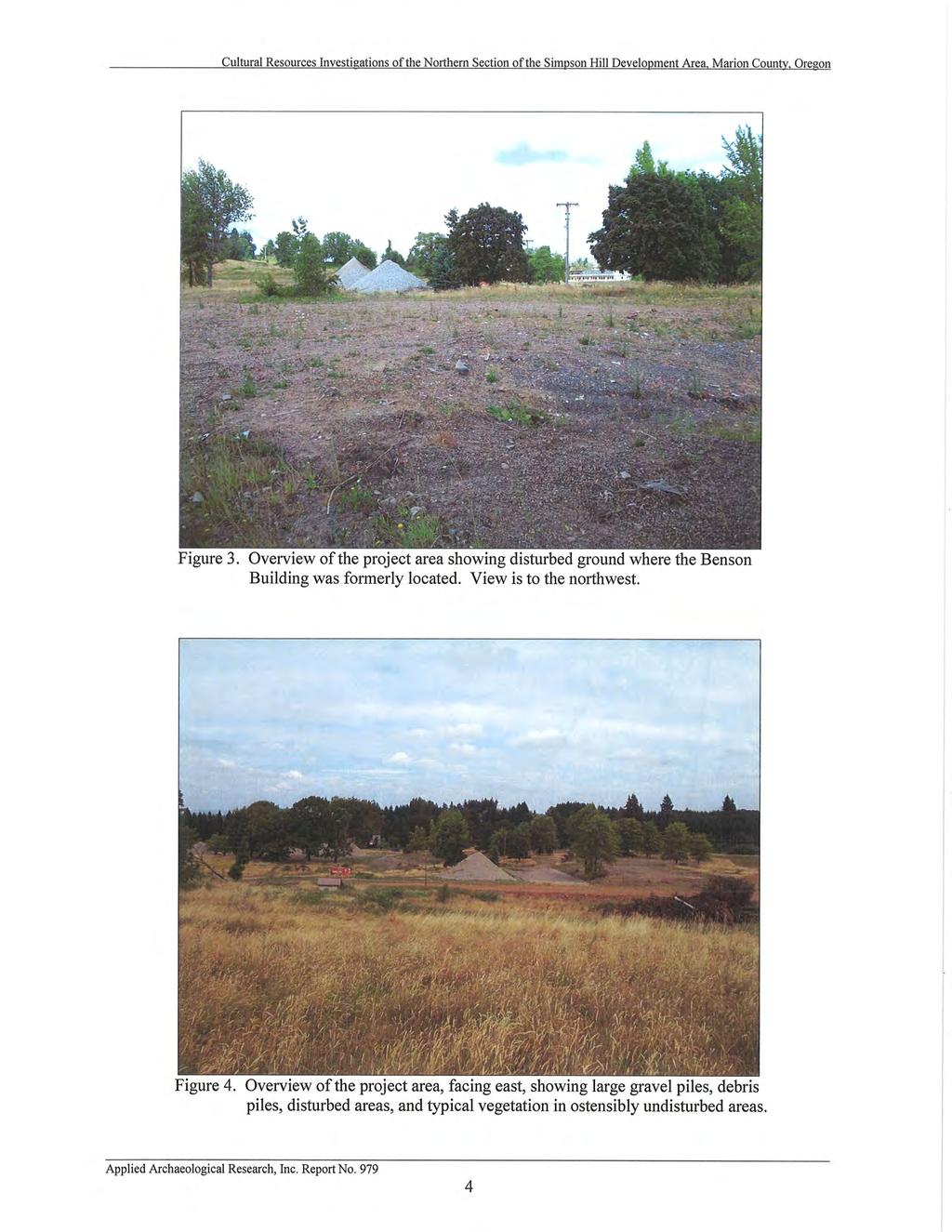
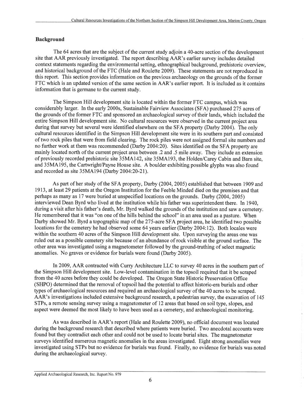
4 Fairview Hills Introduction Simpson Hills, LLC owns approximately 103.8± acres of the former Fairview Training Center property and has prepared this to the adopted Fairview Master Plan to comply with Salem Revised Code (SRC) Chapter 143C.090. Simpson Hills, LLC has elected to prepare a for the northern portion of the site which contains no less than forty (40) acres as permitted under SRC 143C.100.(c). Uncertainties with current market conditions do not support the refinement of the southern portion of the site at this time. This document has been prepared based upon the Fairview Master Plan, applicable portions of the City of Salem Revised Code, the City of Salem Development Design Handbook, and other relevant regulations. Simpson Hills, LLC looks forward to the opportunity of creating a positive impact on the local environment, surrounding neighborhood, and City of Salem. The development of the refinement area will integrate a positive mix of pedestrian and vehicular access while at the same time incorporating generous open spaces with natural drainages, wetlands, and trees. This approach creates a balance between practical development and this natural setting in the South Salem hills. Simpson Hills, LLC is excited about moving forward with this project to provide exciting new housing options and neighborhood commercial opportunities within the local community. This contains many of the desirable elements included in the adopted Fairview Master Plan and is consistent with the Plan because it: Implements critical elements of the Fairview Master Plan such as a focal point Main Entry into the community at the Lindburg Road and Reed Rd. intersection; Preserves and creates generous open spaces and Green Corridors designed to protect the existing natural resources on the property including significant trees and wetlands; Provides a mix of land uses permitted in the FMU-MI zone including needed multifamily residential homes and an accessible small-scale neighborhood commercial / office area; Involves an interconnected street system that blends with off-site properties and follows existing on-site topography / contours; Includes a multi-layered system of pedestrian amenities that provide for efficient and covenient means of travel and access for pedestrians and bicyclists; Offers diverse recreational opportunities for residents such as childrens play areas, Fairview Hills 4
5 recreation centers, sport-court, multi-use path, etc; Incorporates sustainable site development practices by reuse of existing on-site materials such as rock / gravel to minimize material import and haul off; and Complies with the requirements of the FMU zone and other applicable City standards except where refinements to said standards are established herein. In addition to being consistent with the adopted Fairview Master Plan, this Refinement Plan is also compatible and consistent with the Salem Area Comprehensive Plan. The accomplishes this by: Allowing housing opportunities that support affordable housing for a diverse range of incomes mixed with a complementary neighborhood scale commercial / office use; Developing the property in a manner that is convenient, safe, and attractive to pedestrians; Providing public streets that allow for public pedestrian and bicycle circulation and access to mass transit on the existing Battle Creek Road and Fairview Industrial Drive routes; Facilitating the efficient use of land by encouraging compact high-density development (13 to 17 dweling units per acre) that is supportive of mass transit; Large open space areas that protect significant trees, wetlands, and provide for recreational opportunities; Compatibility with adjoining uses such as the Fairview II through the collaborative development of Lindburg Road; Implementation of necessary infrastructure and services such as transporation (as described above), sanitary sewer, stormwater management, and water services, etc; Encourages high densities and sustainable site development practices and efficient use of land as describe above, as well as utilization of construction techniques and management practices that will control soil erosion and stream sedimentation; Providing for a neighborhood scale mix of office/commercial that will enhance and encourage economic opportunities that support the local economy; Including energy efficient multi-family construction that meets modern energy codes with comparatively reduced energy consumption needs; and Improving air and water quality through preservation of significant trees and inclusion of generous open space areas; and a substantial stormwater attenuation area. Fairview Hills 5
6 Figure 1: Vicinity Map Figure 2: Main Entry Concept Fairview Hills 6

7 Figure 3: Area in the Fairview Master Plan context Fairview Hills 7
 to the north, Reed Road SE to the east, 2nd Street (future) to the")
8 Illustrative Site Plan (1) The Fairview Hills includes approximately 43.2± acres of the 103.8± acre property currently owned by Simpson Hills, LLC. As shown below, the Refinement Plan area is generally located in the northern portion of the site, bounded by Lindburg Road (future) to the north, Reed Road SE to the east, 2nd Street (future) to the south, and the Sustainable Fairview Associates (SFA) property to the north and west. At the request of City of Salem staff, a subdivision application is also being submitted for the property. Although that application is being submitted separately from this Refinement Plan, the proposed subdivision lots are included below for illustrative purposes. Figure 4: Area Fairview Hills 8

9 Figure 5: Illustrative Conceptual Site Plan with key site features Fairview Hills 9
, remaining portions of the Fairview Hills property, and other undeveloped portions of the Fairview Master Plan, as")
10 Conscientious advance planning efforts have been made by the Project Team to ensure that the will integrate with surrounding land uses located in the Morningside Neighborhood area. This includes the existing Pringle Creek Community, other approved s (Fairview II), remaining portions of the Fairview Hills property, and other undeveloped portions of the Fairview Master Plan, as illustrated below. Figure 6: Conceptual Shadow Plat Fairview Hills 10
11 The development of the area will occur over time in phases as outlined in Section (11) and (13). General Allocation and Identification of Major Proposed Land Uses (2) The general allocation of major land uses follows the adopted Fairview Master Plan and Figure 143C-2 of the SRC, with only one zone (MI) present in this area as shown on Figure 7 below. Mixed-Intensity (MI) o Residential uses and neighborhood commercial, employment, and civic uses. o 7 to 35 dwelling units per gross acre for all residential development in the FMU zone. o No building used exclusively for a non-residential use shall have a building footprint greater than 6,000 square feet for non-residential development. The area also includes several open space areas comprised of two natural drainages, wetlands, trees, and stormwater quality/detention area. The May 2011 Salem-Keizer Housing Needs Analysis 2012 to 2032 prepared for the Mid- Willamette Valley Council of Governments states that Salem has a deficit of multifamily land and needs approximately 3,283 dwelling units. The density and proposed uses outlined below help to reduce this multifamily deficit. Apartments / Multi-family Residential o Lot 1 (15.43± gross acres): 219± units = 14± dwelling units per acre o Lot 2 (13.40± gross acres): 222± units = 17± dwelling units per acre Neighborhood Commercial, Employment and/or Civic Uses o Lot 3 (9.81± gross acres): 21,000± square feet of buildings including a mix of parking, open space, natural areas, and a stormwater facility. The above number of units and commercial building square footage are approximate as the final numbers may vary depending on market demand. This provides an overall residential use density of 15± units/acre with approximately 441± residential units on 28.83± gross acres of land; and no commercial building Fairview Hills 11

12 footprint exceeding 6,000 square feet in conformance with Table 143C-1 nonresidential uses. Figure 7: FMU Overlay Zones Fairview Hills 12
13 Name, Location and Extent of Existing or Proposed Major Streets (3) The refinement area street network consists of a series of local streets accessing the principal collector street (Lindburg Road), approved as part of the Fairview Refinement Plan II, as well as Battle Creek Road SE (minor arterial) and Reed Road SE (minor arterial). All streets proposed within the area will be dedicated to the public and constructed in conformance with City of Salem local street standards with the exception of Lindburg Road. Lindburg Road will be constructed in accordance with the Fairview II from Reed Road west along the north Fairview Hills property line in a cooperative effort between Simpson Hills, LLC and Sustainable Fairview Associates (SFA). Development of Lot 2 will include construction of a local street ( B Street ) with a 30 foot wide paved street section from Lindburg Road south to Battle Creek Road. The typical section for B Street along the Lot 2 frontage will include curbs, pavement base lift and utilities along with sidewalks, street trees, and lighting on the west side only (Lot 2 frontage). The sidewalks, final pavement lift, street trees and lighting along the Lot 3 frontage on B Street (east side) will be installed with the Lot 3 development (building permit). Figures 9 and 10 in Section (4) below provide further clarification on the B Street improvements associated with Lot 2 development (building permit). Curbs, final pavement lift, sidewalks, street trees, lighting, and utilities for B Street south of 2nd Street will be constructed as part of a subsequent and development (building permit) for the southern portion of the Fairview Hills property. The Lot 3 frontage on Reed Road from Lindburg Road south to 2nd Street will be improved and right-of-way dedicated in accordance with the Preliminary Declaration for Urban Growth Area Development Permit No (UGA) approved by the City of Salem on August 4, 2011 at the time of building construction on Lot 3. The remainder of the future internal street network shown within the refinement area will be built to City local street standards as required with development (building permit) for each lot as outlined in Section (11). Fairview Hills 13

14 Figure 8: Proposed and Existing Streets & Pedestrian Links Concept Fairview Hills 14
15 Typical Street Sections (4) The street sections will conform to City of Salem standards for local streets. Multi-use pathways will generally conform to the typical sections illustrated below. Figure 9: B Street typical section along Lot 2 and Lot 3 frontage from Lindburg Road to 2nd Street Fairview Hills 15
16 Figure 10: B Street typical cross section south of Lot 2 and Lot 3 frontage from 2nd Street to Battle Creek Road Fairview Hills 16
17 Figure 11: Conceptual multi-use path cross section Permitted Land Uses (5) The overlay designation within the area is Mixed-Intensity (MI) as designated on the FMU Overlay Plan (Figure 143C-2) and generally described in SRC 143C.040.(b). Permitted uses are as identified in Table 143C-1 of Salem Revised Codes (SRC) Chapter 143C, including refinements in Section (6), as of the date of submittal of this. The MI overlay permitted uses include all typical residential uses and a variety of neighborhood commercial, employment, and civic uses. Permitted uses of land as well as applicable residential densities are described in Section (2). Please also refer to Sections (6) and (15) for additional information regarding permitted uses. Fairview Hills 17
18 Development Standards for FMU Zones (6) Development standards, regulations and guidelines in this incorporate the general intent of the adopted Fairview Master Plan and provide for development consistent with the Fairview Mixed Use (FMU) zone per SRC Chapter 143C. Development will comply with other pertinent sections of the SRC including, but not limited to, Chapters 68, 69, 125, 126, 130, 131, 132, 133, and 143C, as well as the Development Design Handbook (DDH), unless modified herein. A goal of the is to meet the existing standards except where deviations will result in an improved project design, increased opportunities for economic development, and/or compliance is otherwise impracticable due to existing conditions such as topographic grade, tree preservation, wetlands, and finish grade transition requirements. Multi-family development will either meet the standards contained in the City of Salem Development Design Handbook (DDH) including compliance with the refinements below or will be reviewed by the Planning Commission pursuant to the DDH guidelines and SRC Chapter 120. The following is a summary of the refinements to the Salem Revised Codes (SRC) and City of Salem Development Design Handbook (DDH). Section Current Text Proposed Text SRC 143C.110.(b)(2)(C) SRC 143C.110.(b)(3)(B) A maximum 20 setback from all street rights-of-way in all Overlay Areas, except the L1 area, is required for all primary structures. For multi-family residential development, a maximum of thirty (30) feet per A maximum 20 setback from all street rights-of-way in all Overlay Areas, except the L1 area, is required for all primary structures. However, the maximum 20 setback may be increased by the applicant/owner due to existing conditions such as topographic grade, tree preservation, wetland, and finish grade transition requirements. This section of the code is not applicable to the Refinement Plan area. Fairview Hills 18
19 SRC 143C.110.(b)(6)(A) SRC 143C.110.(b)(6)(B) residential unit and a minimum of six (6) feet per residential unit, with an nonvariable minimum frontage requirement of twenty-four (24) feet. All single family attached homes and multi-family residential complexes shall have their primary orientation to the street. Entrances to multi-family buildings may include entrances to individual units or breezeway/courtyard entrances (i.e. to a cluster of residential units); or All single family attached homes and multi-family residential complexes may have its primary orientation to a side yard when a direct pedestrian walkway is provided between the main entrance and the street, with at least one entrance located not more than 20 from the curb line of the street. All single family attached homes and multi-family residential complexes shall have their primary orientation to the street. Entrances to multi-family buildings may include entrances to individual units or breezeway/courtyard entrances (i.e. to a cluster of residential units). Primary orientation may be the side of the building with a building entrance to promote pedestrian accessibility, or the side of the building with private porches, patios, decks or other building design elements that engage the streetscape and promote eyes on the street and residential security in general; or All single family attached homes and multi-family residential complexes may have its primary orientation to a side yard when a direct pedestrian walkway is provided between the main entrance and the street, with at least one entrance located not more than 20 from the curb line of the street. However, the 20 maximum distance from street curb line to entrance may be increased by the applicant/owner due to Fairview Hills 19
20 DDH 2.E.3.b.3) DDH 2.E.3.b.5) On sites with 75 or more of buildable width, occupy at least 50 percent of the buildable width by a building placed on the setback line. Incorporate into buildings a porch or architectural defined entry space for each ground floor level dwelling unit. Shared porches or entry spaces are permitted provided that the porch or entry area is at least 25 square feet in area per dwelling unit, with no dimension less than 5 feet for each unit. Porches and entry areas shall be open on at least one exterior side, and may be covered or uncovered. All grade level porches shall include hand railings, half walls, or shrubs to define their outside perimeter. DDH 2.E.4.b.1) Offset every two (2) attached dwelling units from the next dwelling unit by at least four (4) feet in depth (See graphics below with the numbers identifying examples of what are considered offsets.) existing conditions such as topographic grade, tree preservation, wetland, and finish grade transition requirements. This section of the code is not applicable to the Refinement Plan area. Incorporate into buildings a porch or architectural defined entry space for each ground floor level dwelling unit. Shared porches or entry spaces are permitted provided that the porch or entry area is at least 25 square feet in area per dwelling unit, with no dimension less than 5 feet for each unit for two to four units and at least 15 square feet in area per dwelling unit, with no dimension less than 3 feet for each unit with five or more units. Porches and entry areas shall be open on at least one exterior side, and may be covered or uncovered. All grade level porches shall include hand railings, half walls, or shrubs to define their outside perimeter. Offset groups of two (2) attached dwelling units or stacks of units as viewed in plan from the adjacent dwelling unit(s) by at least four (4) feet in depth horizontally. Offset stacked dwelling units from each other to differentiate the Fairview Hills 20
 feet over at least 25 percent of the e unit façade. Intervening roofs shall count as offsets.")
21 DDH 2.E.4.b.3) When providing a common entrance, limit the access to not more than four (4) dwelling units. building base and top from the other floor(s). Offsets must be at least two (2) feet over at least 25 percent of the e unit façade. Intervening roofs shall count as offsets. (See Figure 12A, 12B, 12C & 12D below identifying some of the examples of what are considered offsets.) When providing a common entrance, limit the access to not more than six (6) dwelling units. Figure 12A: Example Building Front Offset for refinement to DDH 2.E.4.b.1) as indicated in the above table Fairview Hills 21

 as indicated in")
22 Figure 12B: Example Building Back Offset for refinement to DDH 2.E.4.b.1) as indicated in the above table Figure 12C: Example Building Front Offset for refinement to DDH 2.E.4.b.1) as indicated in the above table Fairview Hills 22
 as indicated in the above table Standards for Conservation of Natural Resources (7) Development within the area will conform to the following portions of the SRC specifically adopted to address")
23 Figure 12D: Example Building Back Offset for refinement to DDH 2.E.4.b.1) as indicated in the above table Standards for Conservation of Natural Resources (7) Development within the area will conform to the following portions of the SRC specifically adopted to address conservation of natural resources within the City. Chapter 68 Preservation of Trees and Vegetation Chapter 69 Landslide Hazards Chapter 126 Wetlands In addition to complying with these regulations and standards, the development will incorporate the following principles. Cultural Resources In the unlikely event that cultural resources are encountered during construction on the site, the Oregon State Historic Preservation Office (SHPO) should immediately be notified and work halted in the vicinity of the finds until they can be inspected and assessed. An inadvertent discovery plan has been included in the Appendix. Fairview Hills 23
24 There are several potential cultural sites identified in the Archaeological Cultural Resources Inventory & Assessment (Exhibit 6) of the Fairview Master Plan dated August 2004, as well as the Appendix A dated June 2004, as shown on Figure 14 below. However, in 2009 and 2010 extensive cultural resource investigations were conducted by Applied Archaeological Research, Inc. (AAR) of the entire 103.8± acre Fairview Hills (Simpson Hills, LLC) property suggesting the development contains very sparse archaeological remains. A copy of the September 9, 2010 AAR investigation has been included in the Appendix. Trees The grove of Oregon White Oaks located in the northeast corner of the refinement area adjacent to Lindburg Road and Reed Road SE is to be preserved as a gateway to the development in conformance with the adopted Fairview Master Plan. Surface Water The area incorporates a storm water attenuation area allowing for natural infiltration to the extent possible. Best management practices (BMPs) will be implemented to maintain high standards of water quality. The stormwater facility will be designed as an extended dry basin that provides both water quantity attenuation and water quality treatment that is appropriate for this setting given the existing soils, hydrology, topography, and surrounding environment. It will be designed in accordance with the Low Impact Development Approaches Handbook adopted by Clean Water Services of Washington County. The facility will be integrated into the surrounding landscaping and will appear as a shallow landscaped depression with a flat bottom that collects and holds stormwater runoff, allowing pollutants to settle and filter out as the water infiltrates into the ground (to the extent possible) prior to release. The entire facility area, including side slopes and treatment area will feature vegetation that is appropriate for the varying conditions within the extended dry basin. Vegetation will be established through dense plantings which will include a variety of native plants as well as non-invasive ornamentals that provide aesthetic and functional value. Species will be selected to assure successful establishment based on climate, soil type, and moisture tolerance. Selections will be made to ensure that they are harmonious with the surrounding sensitive areas and existing vegetation. Fairview Hills 24
25 Soils Minimization of potential erosion of the on-site soils is critical to protecting local streams, wetlands, and drainage courses. Development will comply with City of Salem erosion control standards. Construction areas disturbing more than one (1) acre shall obtain a National Pollutant Discharge Elimination System (NPDES) 1200C permit from the Oregon Department of Environmental Quality (DEQ). Proof of a valid DEQ permit must be submitted to the City of Salem prior to issuance of building permits. Reuse of on-site Materials Construction will reuse the substantial amount of gravel and crushed rock piles that currently exist from prior work on the property when feasible. Utilizing this material for road bases, trenches and structural backfill will reduce the need for importing these materials thereby reducing the impact of construction traffic on local roads and infrastructure. The reuse of materials will also help reduce the carbon footprint. Vegetation Vegetative cover is crucial to the health of the soil structure and the animals that traditionally inhabit the South Salem hills. Establishment and re-establishment of vegetation native to the area is important to the successful maintenance of natural areas. Re-establishment of vegetation within the limits of construction will also be critical to minimizing the potential for erosion and shall be incorporated into construction drawings for development within the area. Wildlife The incorporation of open space and re-establishment of vegetation native to the Willamette Valley will provide habitat inviting local wildlife to share in the diversity of the site that is not typically present in other development projects. Wetland and Tree Inventory (8) Wetlands The Department of State Lands (DSL) has reviewed and concurred with the delineation of existing wetlands located on the property and has issued a removal/fill permit (45110-RF) for the site. The DSL permit identifies the areas of permanent and temporary impacts and outlines the mitigation requirements for the site. Several wetlands will remain on the property and be incorporated into the site s open space. Fairview Hills 25
.")
26 Tree Inventory A certified professional arborist evaluated the trees on the Fairview Hills property. Trees were identified by species, type, size and general condition. The area has several existing trees that will be retained in accordance with the City approved May 4, 2009 tree regulation variance (case no. 09-1). Preservation of trees and vegetation within the refinement area will comply with SRC Chapter 68. Figure 13: Tree Inventory and Conceptual Preservation Plan Fairview Hills 26
27 Methods of Protection for Natural Features (9) Historic Structures The site contains no designated historic structures. The State of Oregon Archaeologist issued a letter dated July 7, 2009, a copy of which is included in the Appendix, stating the project will have no effect on any known cultural resources. No further archaeological research is needed with this project. In order to further protect any potential discovery of cultural resources and to comply with state law an inadvertent discovery plan is included in the Appendix and shall be included as part of the construction documents for every development on the property. Natural Features Mature trees existing at the property and existing wetland areas will be protected for incorporation into open spaces where possible. A tree inventory for the property was previously approved by the City of Salem as Tree Variance Case No Any modifications to the previously approved tree conservation plan will be processed as required by SRC Chapter 68. Trees During all clearing, grading and construction activities, protective fencing shall be installed and maintained around all trees designated for retention by the approved tree conservation plan for the property including any adjustments thereto. Any heritage or significant tree shall have protective fencing at least seventy percent of a circular area beneath the tree measuring one foot in radius for every one-inch of diameter at breast height (dbh), or as otherwise allowed by the project arborist. View Sheds The view sheds identified in the adopted Fairview Master Plan on the western portion of the area have natural topography that may provide for views to the north and east. The layout and development of this area of the may incorporate the natural topography into the site design to help maintain and/or enhance views to the north and east where feasible. Fairview Hills 27

28 Figure 14: Natural Features Fairview Hills 28
29 Maintenance of Infrastructure (10) Streets and infrastructure will be constructed to City local street standards, unless modified herein, and dedicated to the City of Salem. The City will be responsible for maintaining the public right-of-way, streets, sidewalks, lights, trees and public utility infrastructure within the refinement area. The public utility infrastructure typically includes, but is not limited to, public water, fire hydrants, valves, manholes, sanitary sewer, cleanouts, storm drain mains, manholes & catch basins, public storm drain facility, and public street furnishings/trash/recycling cans/etc. A Property Owner Association (POA) will be created to own and manage privately owned green corridors (drainages), pedestrian/bike paths, private site furnishings/trash cans/recycling, and open space within the refinement area. The POA will establish operation and maintenance standards for the private infrastructure, perpetual maintenance of any open space, and community amenities. Construction Phasing of Streets (11) Street construction phasing will be tied to building permits for development on each lot within the refinement area. Lots 1, 2, and 3 are located within the area. Lots 4 and 5 are outside of the refinement area; however street improvements required by the City as a condition of development on these two lots (Lots 4 & 5) is discussed below to describe how the UGA permit conditions of approval are being implemented and to provide a more complete picture of future improvements. We have also included a discussion of anticipated phasing for the remainder of the future conceptual internal street network shown within the area. Lot 1 (Inside of area) Linking Street requirement for Lot 1 is satisfied by either construction of the B Street connection to Battle Creek Road or the widening of Reed Road from Lindburg Road to Battle Creek Road. Boundary Street requirement for Lot 1 is satisfied by improvements to Lindburg Road along full lot frontage in cooperation with SFA assuming development on Lot 2 preceeds Lot 1. If Lot 1 development occurs prior to Lot 2 then Lindburg Road must be constructed from Reed Road westerly across the Lots 1, 2 and 3 frontages. Internal Local Street Network: Half or three-quarter street improvements as defined in SRC Chapter 63 to 1st Street (north boundary) and A Street (west boundary) along the Lot 1 property lines with building permits for development on Lot 1. Fairview Hills 29
30 Lot 2 (Inside of area) Linking Street requirement for Lot 2 is satisfied by either construction of the B Street connection to Battle Creek Road or the widening of Reed Road from Lindburg Road to Battle Creek Road. Boundary Street requirement for Lot 2 is satisifed by improvements to Lindburg Road along the Lot 2 and Lot 3 frontage (north property line) in cooperation with SFA. Internal Local Street Network: Half or three-quarter street improvement as defined in SRC Chapter 63 for B Street (east boundary) along the Lot 2 property line with building permits for Lot 2 development. Lot 3 (Inside of area) Linking Street requirement for Lot 3 is satisfied by either construction of the B Street connection to Battle Creek Road or the widening of Reed Road from Lindburg Road to Battle Creek Road. Boundary Street requirement for Lot 3 is satisfied by improvements to Reed Road along Lot 3 frontage (Lindburg Road to 2nd Street). Internal Local Street Network: Three-quarter local street improvement per City standards to 2nd Street (south boundary) from Reed Road westerly along Lot 3 frontage if building permit/development on Lot 3 occurs prior to Lot 5. Otherwise a local half-street improvement to 2nd Street per City standards for the Lot 3 south boundary is required if Lot 5 has already constructed, or is conditioned to construct, a portion of 2nd Street. Lot 4 (Outside of area) Linking Street requirement is satisfied with Lot 4 frontage on Battle Creek Road. Boundary Street requirement for Lot 4 is satisfied with improvements to Battle Creek along Lot 4 frontage. Internal Local Street Network: Full local street improvements per City standards to 2nd Street (north boundary) from B Street on the east to the west property line. Half or three-quarter local street improvements, as applicable, to A Street (west boundary) along Lot 4 frontage. Final improvements to the Lot 4 side of B Street (west side) is also required. Lot 5 (Outside of area) Linking Street requirement is satisfied with Lot 5 frontage on Battle Creek Road. Boundary Street requirement for Lot 5 is satisfied with improvements to Reed Road and Battle Creek Road along full Lot 5 frontages; and Reed Road right-of-way dedication across full Lot 3 frontage if the Lot 3 Reed Road frontage is not improved at the time of Lot 5 development (building permit). Fairview Hills 30
31 Internal Local Street Network: Local half-street improvements per City standards to 2nd Street (north property boundary) provided Lot 3 development (building permit) preceeds Lot 5 development. If Lot 5 development (building permit) occurs before Lot 3 development, then a three-quarter local street improvement per City standards to 2nd Street from Reed Road westerly along the north boundary of Lot 5 is required. Final improvements to the Lot 5 frontage on B Street (east side) is also required. Figure 15: Proposed and Existing Street Phasing Concept Fairview Hills 31
32 Standards for Phasing of Public Utilities (12) Construction of sanitary sewer, storm drainage, waste disposal, and public utilities will be completed as necessary to fully serve each development phase and be installed to anticipate future development within the refinement area and adjacent properties. Each phase of development in the refinement area will provide the utility extensions and streets stubs necessary to serve adjacent phases in accordance with the concepts shown in this, unless modified by subsequent land use planning actions. Phasing Schedule (13) Development within the area is anticipated to proceed in six to seven phases as market conditions allow. The phases are not intended to indicate the order in which the property will develop but are summarized below to provide a logical explanation of how development could occur for the area. Phase 1 (Lot 2) Phase 1 would consist of the first half of apartments planned for Lot 2, the recreation center, construction of B Street as explained herein, construction of Lindburg Road SE in cooperation with SFA, and the stormwater facility on Lot 3 as required to support development of Lot 2. The first phase will preserve the existing wetlands on the south side of Lindburg Road SE, and existing wetlands and green corridor (drainage) on the west boundary of Lot 2. Phase 1 will also preserve the grove of existing Oregon White Oaks located in the northeast corner of the refinement area adjacent to Lindburg Road SE and Reed Road SE as a gateway to the development in conformance with the adopted Fairview Master Plan. Phase 2 (Lot 2) Phase 2 would consist of the second half of the total planned apartment units to complete the project. This phase will preserve the green corridor (drainage) along the west boundary and the existing wetlands located at the south corner of Lot 2 near B Street. The viewshed in the area of Phase 2 has been incorporated into the conceptual site plan for the apartments by using the existing topography to allow for tiered parking lots and buildings. This tiered approach will allow for some of the apartments to enjoy views to the northeast. Fairview Hills 32
33 Phase 3 (Lot 1) Apartments constructed in two stages on Lot 1, possible stormwater facility expansion/modification, and construction of 1st Street and A Street as explained in Section (11). The first stage would include approximately half of the total apartment units planned for Lot 1 as well as a portion of the multi-use path connecting to the Lot 2 apartments and 1st Street as shown on Figure 20. Phase 3 will preserve and expand the green corridor (drainage) along the east boundary of Lot 1. The conceptual site plan for the planned apartments has incorporated the natural topography of this hillside to capture the north and northeast views. The layout is ringed following the natural contours of the viewshed and steps up the hillside allowing views from most of the planned units. Phase 4 (Lot 1) Phase 4 would consist of the second half of the total planned apartment units and final multi-use path connections to complete the project. This phase also preserves and expands the green corridor (drainage) along the east boundary of Lot 1. The conceptual site plan for the planned apartments has incorporated the natural topography of this hillside to capture the north and northeast views. The layout is ringed following the natural contours of the viewshed and steps up the hillside allowing views from most of the planned units. Phase 5, 6 and/or 7 (Lot 3) These phases would consist of commercial building(s), parking area(s), possible stormwater facility expansion/modification, supporting features such as landscaping and other amenities, and construction of Reed Road frontage improvements, a portion of 2nd Street and B Street as explained in Section (11). This may occur with all the buildings being constructed in one phase or with any combination of buildings depending on market conditions at the time of development. The existing wetlands and green corridor (drainage) located on Lot 3 will also be preserved as part of the development. There are no significant viewsheds identified within the limits of Lot 3. Each phase of development will stand alone with regards to streets and utilities. No phase is to be developed without adequate streets and utilities available. Fairview Hills 33

34 Figure 16: Conceptual Phasing Plan Financial Assurances (14) The Fairview Hills property is subject to the 2005 Infrastructure Agreement executed by Sustainable Fairview Associates, LLC and the City of Salem. The Infrastructure Agreement creates a Development District specifying schedules, cost estimates, and Fairview Hills 34
35 financing for infrastructure projects related to the development of the entire former Fairview Training Center property. The Infrastructure Agreement is currently being updated to insure changes in infrastructure project needs are addressed. Extent the Supplements & Supersedes adopted City Regulations (15) Specific standards that supplement and supersede City regulations are contained in this as outlined previously in the Development Standards for FMU Zones (6). The provisions of the SRC shall apply unless specifically addressed in this. Standards for Interpreting the (16) Development within the area will be designed to meet the intent of the adopted Fairview Master Plan and the Fairview Mixed Use (FMU) zone code. The FMU zone, Fairview Master Plan, and this have land use regulations different from the zoning regulations applicable to other zoning districts and therefore are subject to the hierarchy established under SRC 143C.050. Design Guidelines and Approval Process (17) Future development will be designed to comply with this, the Salem Revised Code, and Development Design Handbook for multi-family developments, including the modifications stated in this document. The City of Salem will review plans for conformance and issue approvals. This will occur through submittal of subdivision and site plan review applications, subsequent (s) and other standard City requirements, as is customary and appropriate. Fairview Hills 35
36 General Landscape Plan (18) Critical elements of the general landscape plan include: 1) retention of mature trees in accordance with the City approved tree conservation plan, including any amendments thereto; 2) preservation of existing wetlands; and 3) providing opportunities for passive and active recreational activities. The layouts shown in the have carefully considered opportunities to protect existing trees and wetlands as well as provide for active and passive recreational activities. Three main landscape types have been included for the area. Natural Open Space with wetlands and drainages. Native vegetation is encouraged within these areas. Open Space and multi-use path areas where active and passive recreational activities are provided. Private Landscape areas falling within the limits of private developments. Plant species tolerant of soil and hydrologic conditions without ongoing irrigation are preferred for all landscaping within the refinement area. In addition to incorporation of native drought tolerant plant and tree species, private development will be required to comply with the applicable sections of the SRC for landscape standards. The landscape plan for the area surrounding the Oregon White Oak grove at the northeast corner of the property will be designed to minimize impacts to the existing trees and/or retain in its current natural state. Street trees will be planted in accordance with SRC Chapter 86 to provide shade tree lined public streets within the limits of the. The general landscape plan shown below further illustrates these concepts. Detailed landscape plans will be submitted when required as part of the standard City requirements for development on each lot. Fairview Hills 36

37 Figure 17: General Conceptual Landscape Plan Fairview Hills 37

38 General Drainage Plan (19) There are three main ridges that define the drainage sub-basins onsite. Existing off-site uphill drainage from basins 2U and 3U currently flowing into the existing drainages on the Fairview Hills property will continue to flow downstream undetained. Figure 18: Existing Drainage Basins Fairview Hills 38
39 The City of Salem has not adopted stormwater quality standards as of the date of this. Therefore, stormwater quality treatment of runoff from impervious surfaces will be provided for all development within the area (43.2± acres) and the remaining 60.6± acres of the Fairview Hills property located outside of the area in conformance with the applicable policies and procedures of Clean Water Services of Washington County (CWS) Design and Construction Standards (R&O 04-09) as of the date of this. This is an example of the innovative solutions being implemented throughout this. Section II. B. of the City of Salem Public Works Department Design Standards for Stormwater Management dated March 16, 2007 states that as interim design standards for stormwater quality the City will accept stormwater quality facilities designed in accordance with Clean Water Services (CWS) standards. Stormwater runoff originating on the Fairview Hills property will be detained in conformance with the City of Salem Public Works Department Design Standards for Stormwater Management dated March 16, 2007 and in effect as of the date of this. A public extended dry detention basin is planned for the northeast corner of the refinement area (Lot 3) to serve public right-of-ways as well as private development areas for the full build-out of the property currently owned by Simpson Hills, LLC (103.8± acres). The basin will be designed and constructed in accordance with CWS standards to provide stormwater quality treatment and stormwater quantity management (detention) per City of Salem standards as approved by the Public Works Department. The stormwater discharge location is planned as a new public storm drain outfall to the West Middle Fork Pringle Creek in the proximity of the Lindburg Road and Reed Road intersection. Fairview Hills 39
. Subsequent to the Fairview Plan TIA, Kittelson & Associates, Inc.")
40 Figure 19: General Conceptual Drainage Plan Traffic Impact Analysis Report (20) The Fairview Master Plan Traffic Impact Analysis (TIA) estimated a total of approximately 17,000 trips upon full development of the former Fairview Training Center site (275± acres). Subsequent to the Fairview Plan TIA, Kittelson & Associates, Inc. (K&A) prepared a memorandum dated July 22, 2009 providing revised trip generation estimates covering the existing Pringle Creek Community, Fairview Hills Fairview Hills 40
41 property, and Sustainable Fairview Associates, LLC property. The July 22, 2009 K&A memorandum reduced the traffic impact to approximately 12,000 trips. Subsequently, K&A prepared another update on January 13, 2012 based on the Fairview Hills which indicates that approximately 5,110 new daily trips would be generated if the refinement area, upon full development, matches the conceptual layouts shown. For further information a copy of the K&A memorandum has been included in the Appendix. Impacts on Existing Structures and Other Development (21) The area is bordered on the north and west by Sustainable Fairview Associates (SFA) which is subject to SRC 143C FMU zoning; on the east by Hillcrest Youth Correctional Facility operated by the Oregon Youth Authority (OYA); and on the south by existing single-family residences. Multi-use pedestrian/bike pathways through the property are important amenities that will increase recreational opportunities in the neighborhood. The multi-use paths will coordinate with the Fairview II. Future SFA refinement plans and Fairview Hills refinement plans will be required to coordinate with all City approved refinement plans and the general intent of the adopted Fairview Master Plan. Fairview Hills 41

42 Figure 20: Pedestrian Connectivity and Multi-Use Pathway Conceptual Plan Fairview Hills 42
43 Impacts on Existing Infrastructure and Public Services (22) The Urban Growth Area (UGA) Development Permit (No. 04-8) coupled with the Infrastructure Agreement (IA) entered into by Sustainable Fairview Associates, LLC and the City of Salem on September 20, 2005 identify the infrastructure improvement needs required due to the impacts on the existing infrastructure and public services that the development of the former Fairview Training Center site will create. The IA provides for the method of financing the infrastructure improvements as well as the timing for construction based on triggers due to traffic impacts (K&A Memo) as the former Fairview Training Center property develops. The refinement area shows development that is consistent with the adopted Fairview Master Plan and the impacts to the off-site infrastructure as outlined in the IA. Location and Extent of Sanitary Sewer, Storm Drainage and Utilities (23) Water, sanitary sewer, and storm drain main lines will be public and constructed within street right-of-ways or easements as required by City standards. Separate public water, sanitary sewer and storm drain easements outside of the right-of-ways may be necessary to serve proposed development. Water, sanitary sewer, and storm drain lines will be sized in accordance with City of Salem design standards. Power, telephone, gas and cable lines will be installed within public utility easements following the alignment of several of the public street right-of-ways. Private sanitary sewer, domestic water, irrigation, fire, storm drains and utilities will be constructed with development of each lot within the area. Final designs will be completed with construction plans for development of each lot and submitted to the City of Salem for review and permitting as required. Fairview Hills 43

44 Figure 21: General Public Utilities Conceptual Plan Fairview Hills 44
45 Existing Historically Significant Resources (24) The adopted Fairview Master Plan inventory does not identify buildings, structures or sites, which possess the criteria for historic resource designation under SRC Chapter 120A.040 or which have been designated as historically significant, as being located within the area. As stated in Section 7, there are several potential cultural sites identified in the Archaeological Cultural Resources Inventory & Assessment (Exhibit 6) of the Fairview Master Plan dated August 2004, as well as the Appendix A dated June 2004, which have been shown on Figure 14. Subsequently two extensive cultural resource investigations focused on the 103.8± acre Fairview Hills development where conducted including background research, pedestrian surveys, the excavation of 170 shovel test pits, and the use of a magnetometer to locate evidence for historic-era burials. The report makes the following statements. No evidence for burials or a cemetery was uncovered during the fieldwork. Despite intensive efforts to locate archaeological deposits, combined results of AAR s surveys suggest that the development area contains very sparse archaeological remains... A copy of the September 9, 2010 AAR investigation has been included in the Appendix. Fairview Hills 45
46 Fairview Hills Appendix 1 Inadvertent Discovery Plan
47 NOTICE: THIS DOCUMENT MUST BE AVAILABLE ON SITE AND MUST BE REVIEWED WITH ALL CONSTRUCTION MANAGERS AND EMPLOYEES INVOLVED IN ANY EARTHWORK FOR THIS PROJECT. Fairview Hills Development Project Human Remains Protocol Treatment of Native American and other Human Remains Discovered Inadvertently or Through Criminal Investigations. Native American burial sites are not simply artifacts of the tribe's cultural past, but are considered sacred and represent a continuing connection with their ancestors. Native American ancestral remains, funerary objects, sacred objects and objects of cultural patrimony associated with Oregon Tribes are protected under state law, including criminal penalties (ORS and ). The laws recognize and codify the Tribes' rights in the decision-making process regarding ancestral remains and associated objects. Therefore both the discovered ancestral remains and their associated objects should be treated in a sensitive and respectful manner by all parties involved. Identification of Human Remains Oregon laws (ORS &.095) outline the types of deaths that require investigation and the accompanying responsibilities for that investigation. The law enforcement official, district medical examiner, and the district attorney for the county where the death occurs are responsible for deaths requiring investigation. Deaths that require investigation include those occurring under suspicious or unknown circumstances. If human remains that are inadvertently discovered or discovered through criminal investigations are not clearly modern, then there is high probability that the remains are Native American and therefore ORS (4) applies, which requires immediate notification with State Police, State Historic Preservation Office, Commission on Indian Services, and all appropriate Native American Tribes. To determine who the "appropriate Native American Tribe" the responsible parties should contact the Legislative Commission on Indian Services (CIS). To determine whether the human remains are Native American the responsible parties should contact the appropriate Native American Tribes at the initial discovery. It should be noted that there may be more than one appropriate Native American Tribe to be contacted. If the human remains are possibly Native American then the area should be secured from further disturbance. The human remains and associated objects should not be disturbed, manipulated, or transported from the original location until a plan is developed in consultation with the above named parties. These actions will help ensure compliance with Oregon state law that prohibits any person willfully removing human remains and/or objects of cultural significance from its original location (ORS ). All parties involved and the appropriate Native American Tribes shall implement a culturally sensitive plan for reburial.
48 Notification State law [ORS (4)] requires that any discovered human remains suspected to be Native American shall be reported to- 1. State Police (current contact Lt. Steven R. Lane, Department of State Police, office phone , cell AKS Engineering & Forestry, LLC Primary Contact J. Michael Poissant, office phone , cell phone Secondary Contact Alex Hurley, office phone , cell phone State Historic Preservation Office (SHPO) Below-Ground Resources contact John Pouley, office phone , Above-Ground Resources contact Ian Johnson, office phone , 4. Commission on Indian Services (CIS) Current contact - Karen Quigley, Director, office phone Karen will provide the list of appropriate Native American Tribes. 5. All appropriate Native American Tribes provided by CIS. This list includes but is not limited to the following: Confederated Tribes of Grand Ronde - Eirik Thorsgard, ; cell Confederated Tribes of Siletz - Robeli Kentta, ; cell Confederated Tribes of Warm Springs - Sally Bird Applied Archaeological Research, Inc. Primary contact - Bill Roulette, Principal Investigator, office phone Secondary contact - Jessica Hale, Project Archaeologist, office phone , cell phone
49 Fairview Hills Appendix 2 July 7, 2009 SHPO Letter
50
51 Fairview Hills Appendix 3 Kittelson & Associates Trip Generation Analysis
52
53 Sustainable Fairview Development Fairview Hills Project #: January 13, 2012 Page 2 breakdown of the size, number, and mixture of these land uses is presented in the next section of this memorandum. TRIP GENERATION Kittelson & Associates, Inc. (KAI) prepared estimates of daily, weekday a.m., and weekday p.m. peak hour vehicle trip ends for Phase II of site development based on empirical observations at similar land uses. These observations are summarized in the standard reference Trip Generation, 8 th Edition, published by the Institute of Transportation Engineers (Reference 1). This methodology is consistent with the methodology followed in the Sustainable Fairview Development Plan. As the data represented in the ITE trip generation manual is primarily collected at suburban locations with little or no transit service and minimal pedestrian or bicycle facilities, the process likely overestimates the trip generation of the proposed mixed use development. To adjust for this, trip generation estimates were reduced by ten percent to represent this multi modal development. The ten percent reduction is consistent with the Transportation Planning Rule (TPR) policies and the City of Salem agreed to its application in this case. The Trip Generation Handbook, published by the Institute of Transportation Engineers (Reference 2) provides estimates for pass by and internal trips. Internal trip reductions for each identified land use were based on the mixed use nature of the proposed development. The mix of land uses proposed in Phase II is roughly equivalent and consistent with the original Sustainable Fairview Development Plan; as such, the same internal trip reductions were applied accordingly. The passby reduction is only applicable to the retail component of the development; as such, pass by trips were deducted from the total trips generated by the retail use. These reductions were subtracted from the total site generated trips to calculate the final net new trips attributable to the site. Table 1 summarizes the estimated site trip generation during a typical weekday as well as during the weekday a.m. and p.m. peak hours for Phase II of the development. Trip generation estimates shown in the table below are rounded to the nearest five trips. Kittelson & Associates, Inc. Portland, Oregon
54 Sustainable Fairview Development Fairview Hills Project #: January 13, 2012 Page 3 Table 1 Estimated Trip Generation Phase II Land Use ITE Code Size (s.f./units) Daily Trips Weekday AM Peak Hour Weekday PM Peak Hour Total In Out Total In Out Fairview Hills Apartment 2, units Internal Trips (5%) (140) (10) (5) (5) (10) (5) (5) Fast-Food Restaurant w/ Drive Thru 934 3,000 1, Pass-By (49%/50%) 1 (740) (70) (35) (35) (50) (25) (25) Shopping Center ,000 Pass-By (34%) (220) (5) (5) 0 (20) (10) (10) Coffee Shop w/ Drive Thru 2, ,000 Pass-By (49%/50%) 2 (1,230) (160) (80) (80) (60) (30) (30) Sustainable Fairview Private School (K-8) 500 1, Internal Trips (4%) students (60) (20) (10) (10) (10) (5) (5) General Office ,000 s.f. Internal Trips (4%) (20) (5) (5) (0) (5) (0) (5) Specialty Retail Center ,000 s.f. Pass-By (34%) 4 (300) (0) (0) (0) (20) (10) (10) City Park acres Internal Trips (4%) (0) (0) (0) (0) (0) (0) (0) Total Site-Generated Trips (Phase II) 10,270 1, , Total Internal Trips (220) (35) (20) (15) (25) (10) (15) 10% TPR Reduction (1,010) (120) (60) (60) (100) (50) (50) Total Pass-By Trips (2,490) (235) (120) (115) (150) (75) (75) NET NEW TRIPS (Phase II) 6, Phase I Net New Trips September 2005 NET NEW TRIPS (Phase I) 1, TOTAL NET NEW TRIPS (Phase I + Phase II) TOTAL NET NEW TRIPS 8,320 1, Pass-by rate for ITE #934 is 49% in the weekday a.m. peak hour and 50% in the p.m. peak hour. 50% assumed for daily. 2 Pass-by rate taken from ITE #934. No pass-by rate is available for ITE # Daily trips estimated based on the relationship of p.m. peak hour trips to daily trips of ITE #530 (Elementary School). No daily trip data is available for ITE # Pass-by rate taken from ITE #820. No pass-by rate is available for ITE # No ITE data is provided for a.m. or p.m. peak hours. Given the relatively small size of the park and its central location within the development, no net new vehicle trips are assumed to occur during the weekday a.m. or p.m. peak hours. As shown in Table 1, Phase II of the development is anticipated to generate approximately 6,550 net new daily trips. Of these trips, 865 (420 in/445 out) are anticipated during the weekday a.m. Kittelson & Associates, Inc. Portland, Oregon
55 Sustainable Fairview Development Fairview Hills Project #: January 13, 2012 Page 4 peak hour and 735 (375 in/360 out) are anticipated during the weekday p.m. peak hour. Overall, Phases I and II combined are estimated to generate 8,320 net new daily trips. AREA FACILITIES PLAN The development team and City of Salem have collectively developed an Area Facilities Plan for the entire Sustainable Fairview development to identify specific required public improvements and the trigger for each improvement. Table 2 summarizes the improvements triggered by Phase II. Table 2 Area Facilities Plan Anticipated Off-Site Improvements Required Public Improvement Battle Creek Road SE/Kuebler Boulevard SE - Construct eastbound and westbound right-turn lanes within the existing right-of-way. - Traffic signal modifications to allow protected permissive left-turns and right-turn overlap phasing. 25 th Street SE/Madrona Avenue SE - Realign Madrona Avenue SE with 25 th Street SE and Airway Drive SE with Madrona Avenue SE. - Widen Madrona Avenue SE to a five-lane crosssection east of the railroad to 25 th Street SE. Commercial Street SE/Madrona Avenue SE - Construct a westbound right-turn lane within the existing right-of-way. Trigger (Net New Daily Trips) Estimated Cost 1 2,000 $300,000 6,000 $3,000, ,000 $175,000 1 Cost estimates in year 2004 dollars. 2 Cost estimate includes right-of-way acquisition. As shown in Table 2, three public improvements are triggered by the combined total of 8,320 net new daily trips generated by Phases I and II. The next transportation improvement is not triggered until the development reaches 12,000 net new daily trips per the Area Facilities Plan. We trust this memorandum addresses the impacts of Phase II of the Sustainable Fairview development. If you any questions, please call us at (503) REFERENCES 1. Institute of Transportation Engineers. Trip Generation, 8 th Edition Institute of Transportation Engineers. Trip Generation Handbook ATTACHMENTS Attachment A Sustainable Fairview Development Area Facilities Plan Kittelson & Associates, Inc. Portland, Oregon
56 Attachment A Area Facilities Plan
57
58
59
60
61 Fairview Hills Appendix 4 September 9, 2010 Cultural Resources Investigation

62
63

64
65
66

67
68
69
70
71
72

73
74
75
76

77
78
79
DRAFT SECTION 4(F) EVALUATION FAIRVIEW CEMETERY
 EVALUATION FAIRVIEW CEMETERY") DRAFT SECTION 4(F) EVALUATION I. DESCRIPTION OF SECTION 4(F) RESOURCE The Section 4(f) resource that could be affected by the proposed action is Fairview Cemetery. The proposed action would require the
DRAFT SECTION 4(F) EVALUATION I. DESCRIPTION OF SECTION 4(F) RESOURCE The Section 4(f) resource that could be affected by the proposed action is Fairview Cemetery. The proposed action would require the
Architectural Review Board Report
 Architectural Review Board Report To: From: Subject: Architectural Review Board Architectural Review Board Meeting: August 16, 2010 Steve Traeger, Principal Urban Designer Laura Beck, ARB Liaison Agenda
TABLE OF CONTENTS. Page. Page
 TABLE OF CONTENTS Chapter 1 INTRODUCTION... 1-1 Background... 1-1 Planning Benefits... 1-1 Comprehensive Planning Law... 1-4 County Partnership... 1-5 Advisory Committee and Staff Structure... 1-5 Plan
COUNTY OF SONOMA PERMIT AND RESOURCE MANAGEMENT DEPARTMENT 2550 Ventura Avenue, Santa Rosa, CA (707) FAX (707)
 FAX (707)") COUNTY OF SONOMA PERMIT AND RESOURCE MANAGEMENT DEPARTMENT 2550 Ventura Avenue, Santa Rosa, CA 95403-2829 (707) 565-1900 FAX (707) 565-8358 NOTICE OF PREPARATION OF A DRAFT ENVIRONMENTAL IMPACT REPORT
COUNTY OF SONOMA PERMIT AND RESOURCE MANAGEMENT DEPARTMENT 2550 Ventura Avenue, Santa Rosa, CA 95403-2829 (707) 565-1900 FAX (707) 565-8358 NOTICE OF PREPARATION OF A DRAFT ENVIRONMENTAL IMPACT REPORT
Memorandum for Tree Survey at the Marywood Residential Development Site in Orange, CA.
 Memorandum Date: January 22, 2015 To: From: Subject: The New Home Company Brianna Bernard, VCS Environmental Memorandum for Tree Survey at the Marywood Residential Development Site in Orange, CA. 1. Introduction
Standing Committee on Planning, Transportation and Environment
 ADMINISTRATIVE REPORT Report Date: September 20, 2013 Contact: Tom Hammel Contact No.: 604.873.7545 RTS No.: 10229 VanRIMS No.: 08-2000-20 Meeting Date: October 9, 2013 TO: FROM: SUBJECT: Standing Committee
A. CALL TO ORDER B. STATEMENT OF THE CHAIR C. BYLAWS D. ADJOURNMENT
 TOWN OF OLIVER Public Hearing Meeting Agenda October 10, 2017, at 7:00 PM Council Chambers Page A. CALL TO ORDER B. STATEMENT OF THE CHAIR C. BYLAWS 1. Zoning Amendment Bylaw 365 Zinfandel Avenue - Contract
Napa County Planning Commission Board Agenda Letter
 Agenda Date: 4/21/2010 Agenda Placement: 9A Napa County Planning Commission Board Agenda Letter TO: FROM: Napa County Planning Commission John McDowell for Hillary Gitelman - Director Conservation, Development
BOARD OF ZONING ADJUSTMENT STAFF REPORT Date: June 4, 2018
 # 5 BOA-000511-2018 BOARD OF ZONING ADJUSTMENT STAFF REPORT Date: June 4, 2018 CASE NUMBER 6182 APPLICANT NAME LOCATION VARIANCE REQUEST ZONING ORDINANCE REQUIREMENT ZONING AREA OF PROPERTY ENGINEERING
Findlay Market Brewery District Restaurant Facility, Utilities and Services
 Request for Proposal: Lease/Operation of Restaurant in Over the Rhine The Crown Building, 1739 Elm Street, Cincinnati, Ohio 45202 Contact: Kimberly Starbuck, 513-309-0191 kim@crownotr.com www.crownotr.com
DRAFT. B. Definitions (Amend TITLE I, Chapter 25, Article 1)
") DRAFT Winery A. Purpose The purpose of this ordinance is to provide for the orderly development of wineries and associated activities within Agricultural and Industrial zones to promote economic development
DRAFT Winery A. Purpose The purpose of this ordinance is to provide for the orderly development of wineries and associated activities within Agricultural and Industrial zones to promote economic development
Attachments: Memo from Lisa Applebee, ACHD Project Manager PowerPoint Slides for October 27, 2009 Work Session
 Date: October 22, 2009 To: From: Re: Mayor and City Council Karen Gallagher Transportation Planner Fairview Avenue Concept Design and Access Management Plan Update and Public Outreach Plan Requested Action:
Liquor License Amendment - Change of Hours
 City of Surrey PLANNING & DEVELOPMENT REPORT Liquor License Amendment - Change of Hours Proposal: Liquor primary license amendment to extend hours of liquor service. Recommendation: Denial Location: 10458-137
TYPE II LAND USE APPLICATION Winery Events Special Use Permit
 LAND MANAGEMENT DIVISION Date Received: TYPE II LAND USE APPLICATION Winery Events Special Use Permit PUBLIC WORKS DEPARTMENT 3050 N. DELTA HWY, EUGENE OR 97408 Planning: 541-682-3577 For Office Use Only
Standing Committee on Policy and Strategic Priorities. General Manager of Development, Buildings and Licensing
 ADMINISTRATIVE REPORT Report Date: December 6, 2018 Contact: Sarah Hicks Contact No.: 604.873.7546 RTS No.: 12753 VanRIMS No.: 08-2000-20 Meeting Date: January 30, 2019 TO: FROM: SUBJECT: Standing Committee
1407 San Pablo Avenue
 Z O N I N G A D J U S T M E N T S B O A R D S t a f f R e p o r t FOR BOARD ACTION APRIL 26, 2012 1407 San Pablo Avenue UP #11-10000054 to establish a full service restaurant with incidental service of
Advancing Agriculture Grape Industry Development Program
 2017-2018 Advancing Agriculture Grape Industry Development Program 1) Objectives: To provide assistance for the establishment of new or more productive vineyards. To assist with the adoption of new technologies
CHAPTER 17: PLANNING AND ZONING Wineries
 CHAPTER 17: PLANNING AND ZONING Wineries 17.56.330 A. Purpose. The purpose of this section is to provide for the orderly development of wineries within agricultural zoning districts and certain commercial,
Napa County Planning Commission Board Agenda Letter
 Agenda Date: 10/15/2014 Agenda Placement: 9C Napa County Planning Commission Board Agenda Letter TO: FROM: Napa County Planning Commission Charlene Gallina for David Morrison - Director Planning, Building
TITLE: AMENDMENT TO STANDISH TOWN CODE, CHAPTER 181, LAND USE PART I (ZONING)
") DRAFT 11/13/12 TITLE: AMENDMENT TO STANDISH TOWN CODE, CHAPTER 181, LAND USE PART I (ZONING) ORDERED, that the Town of Standish hereby ordains the following amendments to the Land Use Ordinance, effective
DRAFT 11/13/12 TITLE: AMENDMENT TO STANDISH TOWN CODE, CHAPTER 181, LAND USE PART I (ZONING) ORDERED, that the Town of Standish hereby ordains the following amendments to the Land Use Ordinance, effective
Planning Rationale. Zoning By-Law Amendment and Street Closing Applications. 193 and 200 Lees Avenue
 Planning Rationale Zoning By-Law Amendment and Street Closing Applications February 26, 2013 Our Mission Transformation through transportation. Our Vision To leverage the power of transportation and community
COUNTY OF MONTEREY CONTRACTS/PURCHASING DIVISION
 COUNTY OF MONTEREY CONTRACTS/PURCHASING DIVISION Date: August 13, 2009 To: From: Department Heads Michael R. Derr- Contracts/Purchasing Officer Subject: County Vending Machine Policy The following information
STAFF REPORT. Zoning Text Amendment #PLN , Limited/Craft Breweries and Distilleries (Countywide)
") COUNTY OF PRINCE WILLIAM 5 County Complex Court, Prince William, Virginia 22192-9201 PLANNING MAIN (703) 792-7615 FAX (703) 792-4758 OFFICE wwwpwcgovorg/planning Christopher M Price, AICP Director of Planning
COUNTY OF PRINCE WILLIAM 5 County Complex Court, Prince William, Virginia 22192-9201 PLANNING MAIN (703) 792-7615 FAX (703) 792-4758 OFFICE wwwpwcgovorg/planning Christopher M Price, AICP Director of Planning
Zoning Text Amendment DPA , Provide for the Production of Mead, Cider and Similar Beverages on A-1 Agriculture Properties (County Wide)
") COUNTY OF PRINCE WILLIAM 5 County Complex Court, Prince William, Virginia 22192-9201 PLANNING MAIN (703) 792-7615 FAX (703) 792-4758 OFFICE www.pwcgov.org/planning Christopher M. Price, AICP Director of
COUNTY OF PRINCE WILLIAM 5 County Complex Court, Prince William, Virginia 22192-9201 PLANNING MAIN (703) 792-7615 FAX (703) 792-4758 OFFICE www.pwcgov.org/planning Christopher M. Price, AICP Director of
CITY OF VANCOUVER ADMINISTRATIVE REPORT
 CITY OF VANCOUVER ADMINISTRATIVE REPORT Report Date: June 10, 2008 Author: Lucia Cumerlato Phone No.: 604.871.6461 RTS No.: 07422 VanRIMS No.: 08-2000-31 Meeting Date: June 26, 2008 TO: FROM: SUBJECT:
OREGON WINE COUNTRY PLATES TOURISM PROMOTION DISTRIBUTION GUIDELINES
 OREGON WINE COUNTRY PLATES TOURISM PROMOTION DISTRIBUTION GUIDELINES OREGON TOURISM COMMISSION 250 Church Street SE, Suite 100 Salem, Oregon 97301 503.967.1560 Overview ORS 805.274 mandates that, After
Napa County Planning Commission Board Agenda Letter
 Agenda Date: 3/4/2015 Agenda Placement: 10A Napa County Planning Commission Board Agenda Letter TO: FROM: Napa County Planning Commission David Morrison - Director Planning, Building and Environmental
TOWN OF EMMITSBURG 2009 COMPREHENSIVE PLAN
 TOWN OF EMMITSBURG 2009 COMPREHENSIVE PLAN Emmitsburg Town Council Public Comment Draft August 13, 2009 Town of Emmitsburg 300A South Seton Avenue Emmitsburg, MD 21727 www.emmitsburgmd.gov TOWN OF EMMITSBURG
Supports Item No. 2 CS&B Committee Agenda November 18, 2010
 Supports Item No. 2 CS&B Committee Agenda November 18, 2010 ADMINISTRATIVE REPORT Report Date: October 29, 2010 Contact: Lucia Cumerlato Contact No.: 604.871.6461 RTS No.: 08884 VanRIMS No.: 08-2000-20
Napa County Planning Commission Board Agenda Letter
 Agenda Date: 10/19/2016 Agenda Placement: 9B Napa County Planning Commission Board Agenda Letter TO: FROM: Napa County Planning Commission John McDowell for David Morrison - Director Planning, Building
Uniform Rules Update Final EIR APPENDIX 6 ASSUMPTIONS AND CALCULATIONS USED FOR ESTIMATING TRAFFIC VOLUMES
 APPENDIX 6 ASSUMPTIONS AND CALCULATIONS USED FOR ESTIMATING TRAFFIC VOLUMES ASSUMPTIONS AND CALCULATIONS USED FOR ESTIMATING TRAFFIC VOLUMES This appendix contains the assumptions that have been applied
LEAN PRODUCTION FOR WINERIES PROGRAM
 LEAN PRODUCTION FOR WINERIES PROGRAM 2015-16 An Initiative of the Office of Green Industries SA Industry Program and the South Australian Wine Industry Association, in association with Wine Australia South
South County Outreach Meetings
 South County Outreach Meetings April 8 th & 11 th, 2019 COUNTY OF SANTA CLARA, PLANNING DEPARTMENT JACQUELINE ONCIANO, MANIRA SANDHIR, MICHAEL MEEHAN, VALERIE NEGRETE, JOANNA WILK. 1 Background / Update
Development Services Department, Community Development Division
 AGENDA ITEM: 4. DATE: 02-26-18 STAFF REPORT CONDITIONAL USE PERMIT NO. 17-32 DATE: TO: FROM: APPLICANT: Lancaster Planning Commission Development Services Department, Community Development Division Daniel
PART 2. SIGNS Chapter 2J. Specific Service (Logo) Signs
 Signs") PART 2. SIGNS Chapter 2J. Specific Service (Logo) Signs TABLE OF CONTENTS Chapter 2J. SPECIFIC SERVICE SIGNS Page Section 2J.a Introduction............................................................ 2J-1
PART 2. SIGNS Chapter 2J. Specific Service (Logo) Signs TABLE OF CONTENTS Chapter 2J. SPECIFIC SERVICE SIGNS Page Section 2J.a Introduction............................................................ 2J-1
REPRESENTATIVE: Ben Nelson Black Forest Rd. Planning Commission Hearing Date: 2/20/2018 Board of County Commissioners Hearing Date 3/13/2018
 COMMISSIONERS: DARRYL GLENN (PRESIDENT) MARK WALLER (PRESIDENT PRO TEMPORE) STAN VANDERWERF LONGINOS GONZALEZ PEGGY LITTLETON PLANNING AND COMMUNITY DEVELOPMENT DEPARTMENT CRAIG DOSSEY, EXECUTIVE DIRECTOR
New Opportunities for Toronto s Street Food Vendors
 New Opportunities for Toronto s Street Food Vendors Licensing and Standards Committee Tuesday, March 18, 2014 Tracey Cook Executive Director Carleton Grant Director, Policy & Strategic Support Municipal
Paul D. Ralph, BES, RPP, MCIP, Commissioner, Development Services Department
 Public Report To: From: Report Number: Development Services Committee Paul D. Ralph, BES, RPP, MCIP, Commissioner, Development Services Department DS-17-37 Date of Report: February 2, 2017 Date of Meeting:
Streamlining Food Safety: Preventive Controls Brings Industry Closer to SQF Certification. One world. One standard.
 Streamlining Food Safety: Preventive Controls Brings Industry Closer to SQF Certification One world. One standard. Streamlining Food Safety: Preventive Controls Brings Industry Closer to SQF Certification
Food Primary Liquor License Amendment
 City of Surrey PLANNING & DEVELOPMENT REPORT Food Primary Liquor License Amendment Proposal: Permit a food primary liquor license with hours of liquor service past midnight for a newly-approved eating
ARTICLE 8 C-H, COMMERCIAL-HIGHWAY DISTRICT
 ARTICLE 8 C-H, COMMERCIAL-HIGHWAY DISTRICT SECTION 8.01 INTENT The Commercial-Highway District is established to accommodate those businesses offering a broad range of goods and services, including both
Fairfield Public Schools Family Consumer Sciences Curriculum Food Service 30
 Fairfield Public Schools Family Consumer Sciences Curriculum Food Service 30 Food Service 30 BOE Approved 05/09/2017 1 Food Service 30 Food Service 30 Students will continue to participate in the school
RESOLUTION NO
 RESOLUTION NO. 1891-17 A RESOLUTION OF THE CITY COUNCIL OF THE CITY OF WESTLAKE VILLAGE APPROVING A MODIFICATION TO CONDITIONAL USE PERMIT NO. 16-004 RELATIVE TO AN INCREASE TO THE SIZE OF THE TASTING
ATTACHMENT C NOTICE OF EXEMPTION. Santa Barbara County Clerk of the Board of Supervisors
 ATTACHMENT C NOTICE OF EXEMPTION TO: Santa Barbara County Clerk of the Board of Supervisors FROM: Dana Eady, Santa Barbara County Planning and Development Department The project or activity identified
Napa County Planning Commission Board Agenda Letter
 Agenda Date: 5/18/2016 Agenda Placement: 9C Napa County Planning Commission Board Agenda Letter TO: FROM: Napa County Planning Commission Charlene Gallina for David Morrison - Director Planning, Building
BILL NUMBER: AB 727 BILL TEXT AMENDED IN ASSEMBLY MARCH 25, 2011 FEBRUARY 17, 2011
 BILL NUMBER: AB 727 BILL TEXT AMENDED AMENDED IN ASSEMBLY MARCH 25, 2011 INTRODUCED BY Assembly Member Mitchell FEBRUARY 17, 2011 An act to add Chapter 6.5 (commencing with Section 12405) to Part 2 of
6.0 COMMENT LETTERS AND RESPONSES TO COMMENTS
 City of Orange Tustin Street/Katella Avenue Intersection Right Turn Lane and Bus Turnout Project 6.0 COMMENT LETTERS AND RESPONSES TO COMMENTS The 20-day public review period for the Mitigated Negative
MOBILE FOOD VENDING TEXT AMENDMENT COMMUNITY INPUT MEETING
 MOBILE FOOD VENDING TEXT AMENDMENT COMMUNITY INPUT MEETING August 11, 2016 Welcome & Introductions Meeting Purpose Project background Review current standards and recommended standards Concerns and Feedback
MOBILE FOOD VENDING TEXT AMENDMENT COMMUNITY ADVISORY GROUP MEETING
 MOBILE FOOD VENDING TEXT AMENDMENT COMMUNITY ADVISORY GROUP MEETING January 8, 2015 Welcome & Introductions Purpose Process Project Background Review of Regulations Proposed Changes Questions and Feedback
SAN JOAQUIN VALLEY UNIFIED AIR POLLUTION CONTROL DISTRICT COMPLIANCE DEPARTMENT COM 2293
 SAN JOAQUIN VALLEY UNIFIED AIR POLLUTION CONTROL DISTRICT COMPLIANCE DEPARTMENT COM 2293 APPROVED: DATE: April 3, 2012 Morgan Lambert Director of Compliance TITLE: SUBJECT: RULE 4694 WINERY FERMENTATION
City of Surrey PLANNING & DEVELOPMENT REPORT File:
 City of Surrey PLANNING & DEVELOPMENT REPORT PROPOSAL: Planning Report Date: July 14, 2008 Winery Special Events Area Endorsement (Liquor License) in order to permit an existing winery to host special
October 27, p.m.
 1 0 October, p.m. OREGON LIQUOR CONTROL MODERNIZATION ACT Relating to alcoholic beverages. Be It Enacted by the People of the State of Oregon: PURPOSES FOR STATE LIQUOR REGULATION SECTION 1. The people
UNITED STATES SECURITIES AND EXCHANGE COMMISSION Washington, D.C FORM 8-K
 UNITED STATES SECURITIES AND EXCHANGE COMMISSION Washington, D.C. 20549 FORM 8-K CURRENT REPORT Pursuant to Section 13 or 15(d) of the Securities Exchange Act of 1934 Date of Report (Date of earliest event
GUIDELINES FOR THE INSTALLATION AND USE OF OPEN-AIR BARBECUES
 CALIFORNIA CONFERENCE OF DIRECTORS OF ENVIRONMENTAL HEALTH GUIDELINES FOR THE INSTALLATION AND USE OF OPEN-AIR BARBECUES revised July 2008 BACKGROUND This guideline was originally created in May 1999.
CUP17-14 CONDITIONAL USE PERMIT REQUEST HIGHWAY 94 SOUTH
 CUP 17-14 CONDITIONAL USE PERMIT REQUEST - 2711 HIGHWAY 94 SOUTH Application: Owner: Applicant: Use Requested: Property Zoning: Area: Location: CUP17-14 Defiance Ridge Vineyards, LLC Chuck Gillentine,
THE VINE AT A GLANCE CALENDAR SEPTEMBER GENERAL PLAN OPEN HOUSE SEPTEMBER 18 5:30-7:00 PM. Utility Rate Change. New Recreation Program
 THE VINE AT A GLANCE Utility Rate Change New Recreation Program GENERAL PLAN OPEN HOUSE SEPTEMBER 18 5:30-7:00 PM General Plan Open House Recycling Program CALENDAR SEPTEMBER 03 Labor Day - City Office
PLANNING & COMMUNITY DEVELOPMENT DEPARTMENT STAFF REPORT
 PLANNING & COMMUNITY DEVELOPMENT DEPARTMENT STAFF REPORT DATE: TO: Hearing Officer SUBJECT: Conditional Use Permit #6583 LOCATION: APPLICANT: ZONING DESIGNATION: GENERAL PLAN DESIGNATION: CASE PLANNER:
LIQUOR LICENSE TRANSFER INFORMATION
 LIQUOR LICENSE TRANSFER INFORMATION City of Carbondale City Clerk 200 S. Illinois Avenue Carbondale, Illinois 62901 Phone (618) 457-3281 Fax (618) 457-3282 Explorecarbondale.com LICENSE CLASSIFICATIONS
Ridge. 137 Lot Entitled Subdivision in the City of Plymouth, California Website & Video: Listed at $2,950,000
 Shenandoah Ridge 147 Acres in the Shenandoah Valley Wine Region 137 Lot Entitled Subdivision in the City of Plymouth, California 95669 Website & Video: www.shenandoahplymouth.com Listed at $2,950,000 Prepared
LIVE Wines Backgrounder Certified Sustainable Northwest Wines
 LIVE Wines Backgrounder Certified Sustainable Northwest Wines Principled Wine Production LIVE Wines are independently certified to meet strict international standards for environmentally and socially responsible
Food Primary Liquor License Amendment
 City of Surrey PLANNING & DEVELOPMENT REPORT File: Food Primary Liquor License Amendment Proposal: Amend Food Primary Liquor License to extend hours of operation for an existing restaurant. Recommendation:
TOWN OF BURLINGTON RULES AND REGULATIONS FOR THE LICENSING AND SALE OF ALCOHOLIC BEVERAGES amendments (see listing on last page)
") TOWN OF BURLINGTON RULES AND REGULATIONS FOR THE LICENSING AND SALE OF ALCOHOLIC BEVERAGES amendments (see listing on last page) I. DEFINITIONS. 1. Full Menu Dining Establishment. A restaurant which has
TOWN OF BURLINGTON RULES AND REGULATIONS FOR THE LICENSING AND SALE OF ALCOHOLIC BEVERAGES amendments (see listing on last page) I. DEFINITIONS. 1. Full Menu Dining Establishment. A restaurant which has
CST SERVICES LLC Part of the CST Brands, Inc. Family of Companies
 CST SERVICES LLC Part of the CST Brands, Inc. Family of Companies August 16, 2013 TO: City of Keller, Texas City Council Members Planning and Zoning Commission RE: Proposed Corner Store #1563 Northeast
Fairview Addition. Contingency Plan Implementation Case Study
 Fairview Addition Contingency Plan Implementation Case Study Mining history has affected land use planning & incentives for redevelopment Historical Use & Development does not always lead to identification
CHAPTER 9.50 Outdoor Dining
 CHAPTER 9.50 Outdoor Dining Sections: 09.50.005 Purpose 09.50.010 Definitions 9.50.020 General Outdoor Dining Requirements 9.50.030 Sidewalk Dining Requirements 9.50.040 Parking Space Dining Requirements
MEMORANDUM. Approval of a Construction Contract for the Mount Vernon Road at Vermack Road Intersection Improvement Project
 MEMORANDUM To: From: Mayor and City Council Michael Smith, Public Works Director Date: May, 08 Subject: Approval of a Construction Contract for the Mount Vernon Road at Vermack Road Intersection Improvement
PLANNING & COMMUNITY DEVELOPMENT DEPARTMENT STAFF REPORT. 927 & 929 E. Colorado Boulevard (Annapurna Grill)
") PLANNING & COMMUNITY DEVELOPMENT DEPARTMENT STAFF REPORT DATE: TO: Hearing Officer SUBJECT: Conditional Use Permit #6607 LOCATION: APPLICANT: ZONING DESIGNATION: GENERAL PLAN DESIGNATION: CASE PLANNER:
PLANNING & COMMUNITY DEVELOPMENT DEPARTMENT STAFF REPORT DATE: TO: Hearing Officer SUBJECT: Conditional Use Permit #6607 LOCATION: APPLICANT: ZONING DESIGNATION: GENERAL PLAN DESIGNATION: CASE PLANNER:
AGENDA ITEM 2 A Action Item. Brian James, Planning and Marketing Manager. Cameron Park Route Changes with Expansion of Service to El Dorado Hills
 AGENDA ITEM 2 A Action Item MEMORANDUM DATE: June 1, 2017 TO: FROM: SUBJECT: Brian James, Planning and Marketing Manager Cameron Park Route Changes with Expansion of Service to El Dorado Hills REQUESTED
ORLEANS GARDENS SHOPPING CENTRE 1615 ORLEANS BOULEVARD CITY OF OTTAWA, ONTARIO TRAFFIC UPDATE. Prepared for:
 ORLEANS GARDENS SHOPPING CENTRE 1615 ORLEANS BOULEVARD CITY OF OTTAWA, ONTARIO TRAFFIC UPDATE Prepared for: Orleans Gardens Shopping Centre Inc. 2851 John Street, Suite 1 Markham, ON K3R 5R7 June 12, 2015
COLORADO REVISED STATUTES, TITLE 35, AGRICULTURE
 COLORADO REVISED STATUTES, TITLE 35, AGRICULTURE ARTICLE 29.5: COLORADO WINE INDUSTRY DEVELOPMENT ACT Section 35-29.5-101. Short title. 35-29.5-101.5. Legislative declaration. 35-29.5-102. Definitions.
STANDARD ADMINISTRATIVE PROCEDURE
 STANDARD ADMINISTRATIVE PROCEDURE 28.99.99.M0.01 Service of Food by Non-University Vendors Approved December 21, 2010 Revised February 24, 2014 Next scheduled review: February 24, 2019 Standard Administrative
Subject: Industry Standard for a HACCP Plan, HACCP Competency Requirements and HACCP Implementation
 Amendment 0: January 2000 Page: 1 V I S C New Zealand Subject: Industry Standard for a HACCP Plan, HACCP Competency Requirements and HACCP Implementation Reference Nos: VISC 1 Date issued: 27 January 2000
PROJECT DESCRIPTON AND FINDINGS OF FACT CONDITIONAL USE PERMIT W. Ventura Boulevard
 PROJECT DESCRIPTON AND FINDINGS OF FACT CONDITIONAL USE PERMIT 13730 W. Ventura Boulevard REQUEST As allowed under Section 12.24 W 1 of the Los Angeles Municipal Code, the applicant is requesting a Conditional
FOOD SERVICE APPLICATION EAST LANSING ART FESTIVAL
 FOOD SERVICE APPLICATION EAST LANSING ART FESTIVAL May 19-20, 2018 Date received: PLEASE TYPE OR PRINT CLEARLY Business Name: Contact Name: Title: Mailing Address: Day Phone: Cell Phone: E-Mail Address:
SECTION 2: PROJECT DESCRIPTION
 City of Napa - St. Regis Napa Valley Project Draft EIR Project Description SECTION 2: PROJECT DESCRIPTION This Environmental Impact Report (EIR) analyzes the potential environmental effects of the proposed
C. CEQA Determination: Categorically exempt pursuant to Section of the CEQA Guidelines ( New Construction or Conversions of Small Structures )
") Z O N I N G A D J U S T M E N T S B O A R D S t a f f R e p o r t FOR BOARD ACTION JULY 14, 2011 2020 Shattuck Avenue UP #11-10000011 to add incidental service of beer, wine and distilled spirits at a
Z O N I N G A D J U S T M E N T S B O A R D S t a f f R e p o r t FOR BOARD ACTION JULY 14, 2011 2020 Shattuck Avenue UP #11-10000011 to add incidental service of beer, wine and distilled spirits at a
Skamania-Klickitat County Knotweed Control Project
 Skamania-Klickitat County Knotweed Control Project Agreement K1752 Skamania County Noxious Weed Control Program Post Office Box 369 704 SW Rock Creek Drive Stevenson, WA 98648 509-427-3942 soliz@co.skamania.wa.us
Supports Item No. 2 CS&B Committee Agenda January 20, 2011
 Supports Item No. 2 CS&B Committee Agenda January 20, 2011 ADMINISTRATIVE REPORT Report Date: January 7, 2011 Contact: Sadhu Johnston Contact No.: 604-873-7627 RTS No.: 8917 VanRIMS No.: 08-2000-20 Meeting
Post Office Box 686 Springfield, Virginia P: F:
 Fairfax County Parkway Property Address: 8249-A Backlick Rd, Lorton, VA 22079, Fairfax County Lease Terms and Information: Rent / SF / Yr + Svs: $12.00 / nnn; Terms: Negotiable; 4,047 SqFt available, with
A. Land Use Designations: General Plan: Downtown Downtown Area Plan: Core Area Zoning: C-DMU Core, Commercial-Downtown Mixed-Use Core
 Z O N I N G A D J U S T M E N T S B O A R D S t a f f R e p o r t FOR BOARD ACTION JANUARY 10, 2013 2068 Center Street Use Permit #12-10000044 to allow incidental service of beer, wine and distilled spirits
Napa County Planning Commission Board Agenda Letter
 Agenda Date: 7/1/2015 Agenda Placement: 10A Continued From: May 20, 2015 Napa County Planning Commission Board Agenda Letter TO: FROM: Napa County Planning Commission John McDowell for David Morrison -
Section 1. Appendix A, "Zoning" of the Code of the City of Charlotte is hereby amended as follows:
 Petition No. 2013-90 Petitioner: Charlotte-Mecklenburg Planning Department Revised 7-8-14 with Zoning Committee recommendation AN ORDINANCE AMENDING APPENDIX A OF THE CITY CODE ZONING ORDINANCE ORDINANCE
PLANNING & COMMUNITY DEVELOPMENT DEPARTMENT STAFF REPORT. CD-4 (Central District Specific Plan, Pasadena Playhouse sub-district)
") PLANNING & COMMUNITY DEVELOPMENT DEPARTMENT STAFF REPORT DATE: TO: Hearing Officer SUBJECT: Conditional Use Permit # 6578 LOCATION: APPLICANT: ZONING DESIGNATION: GENERAL PLAN DESIGNATION: CASE PLANNER:
PLANNING & COMMUNITY DEVELOPMENT DEPARTMENT STAFF REPORT DATE: TO: Hearing Officer SUBJECT: Conditional Use Permit # 6578 LOCATION: APPLICANT: ZONING DESIGNATION: GENERAL PLAN DESIGNATION: CASE PLANNER:
Liquor Policy Review Recommendations #19 and 20: Phased-in Implementation of Liquor in Grocery stores
 Liquor Control and Licensing Branch POLICY DIRECTIVE No: 15-01 February 26, 2015 To: Re: All LCLB staff All Industry Associations All Local Government, First Nations, and Police Agencies Liquor Policy
Improving Enquiry Point and Notification Authority Operations
 Improving Enquiry Point and Notification Authority Operations EAC Public Private Sector Workshop on the WTO TBT and SPS Agreements Diane C. Thompson March 21 22, 2016 Nairobi, Kenya EAC Public Private
Large-scale Accessory Winery Event. Large-scale accessory winery event is an event hosted by the on-site winery or off-site
 WINERY OR OFF-SITE WINE CELLAR SUPPLEMENTAL INFORMATION AND EVENT PLAN SAN JOAQUIN COUNTY COMMUNITY DEVELOPMENT DEPARTMENT 1810 E. HAZELTON AVENUE, STOCKTON CA 95205 BUSINESS PHONE: (209) 468-3121 Business
Memorandum. May 10, To: All temporary food vendor applicants. From: Okanogan County Public Health
 May 10, 2016 Memorandum To: All temporary food vendor applicants From: Okanogan County Public Health Please read this information below before you fill out the temporary food permit application. If any
GEORGIA DEPARTMENT OF CORRECTIONS Standard Operating Procedures. Policy Number: Effective Date: 1/16/2018 Page Number: 1 of 6
 Policy Number: 409.04.03 Effective Date: 1/16/2018 Page Number: 1 of 6 I. Introduction and Summary: A. All Food Service Directors, Managers, and Supervisors of Georgia Department of Corrections (GDC) State
REQUEST FOR PROPOSAL FOR THE CONTRACT TO PROVIDE FOOD SERVICES FOR THE SUNDRIDGE-STRONG-JOLY ARENA & HALL SNACK BAR
 REQUEST FOR PROPOSAL FOR THE CONTRACT TO PROVIDE FOOD SERVICES FOR THE SUNDRIDGE-STRONG-JOLY ARENA & HALL SNACK BAR For the period from award (Tentatively October 1, 2016 or sooner) through and including
Healthy Food Procurement in the County of Los Angeles Public Health Alliance of Southern California Leadership Council May 31, 2013
 Healthy Food Procurement in the County of Los Angeles Public Health Alliance of Southern California Leadership Council May 31, 2013 Michelle Wood, MPP Division of Chronic Disease and Injury Prevention
EPO 2013/ CR-34 Obed Mountain Mine Monthly Status Report - January 2017
 WESTMORELAND COAL COMPANY -Obed Mountain Mine EPO 2013/ CR-34 Obed Mountain Mine Monthly Status Report - January 2017 Issued February 7th, 2017 Monthly Status Report January Issued February 7th, 2017 Table
PROPERTY DESCRIPTION PROPOSED CONSTRUCTION
 September 30, 2010 Project No. 10797 11A Ms. Ginger Hitzke Hitzke Development Corporation 251 Autumn Drive, Suite 100 San Marcos, CA 92069 Subject: Interpretive Report for Infiltration System Design, Proposed
Name of Event Event Date(s) Firm Name Telephone Fax. Address. City State Zip Code Booth # On Site Contact Title. Signature Date
 Firm Name Telephone Fax. Address. City State Zip Code Booth # On Site Contact Title. Signature Date") AUTHORIZATION REQUEST SAMPLE FOOD AND/OR BEVERAGE DISTRIBUTION SAVOR has the exclusive food and beverage distribution rights within Chesapeake Energy Arena and the Cox Convention Center. Exposition sponsoring
AUTHORIZATION REQUEST SAMPLE FOOD AND/OR BEVERAGE DISTRIBUTION SAVOR has the exclusive food and beverage distribution rights within Chesapeake Energy Arena and the Cox Convention Center. Exposition sponsoring
PUBLIC HEARING NOTICE PROPOSED AMENDMENT TO CHAPTER 331, ZONING RE: CABARET OVERLAY ZONE
 PUBLIC HEARING NOTICE PROPOSED AMENDMENT TO CHAPTER 331, ZONING RE: CABARET OVERLAY ZONE NOTICE is hereby given that the Council of the City of New Rochelle, New York, will hold a Public Hearing pursuant
2. The proposal has been sent to the Virtual Screening Committee (VSC) for evaluation and will be examined by the Executive Board in September 2008.
 for evaluation and will be examined by the Executive Board in September 2008.") WP Board 1052/08 International Coffee Organization Organización Internacional del Café Organização Internacional do Café Organisation Internationale du Café 20 August 2008 English only Projects/Common
WP Board 1052/08 International Coffee Organization Organización Internacional del Café Organização Internacional do Café Organisation Internationale du Café 20 August 2008 English only Projects/Common
Our Project file: TPI-2017P Highway 27, Vaughan, Proposed Restaurant, Parking Justification Study Letter Response to Study Peer Review
 13 February 22, 2018 c/o Ms. Nicole Sampogna Associate Planner Evans Planning Inc. 8481 Keele Street, Unit 12 Vaughan, Ontario, L4K1Z7 Our Project file: TPI-2017P004 Re: 9732 Highway 27, Vaughan, Proposed
Letter of Determination
 SAN FRANCISCO (Clerically Amended - December 30, 2014) 1650 Mission St. Sue 400 San Francisco, CA 94103-2479 December 2, 2014 San Francisco, CA 94107 Site Address: Assessor s Block/Lot: Zoning District:
PLAN COMMISSION AGENDA ITEM EXECUTIVE SUMMARY
 PLAN COMMISSION AGENDA ITEM EXECUTIVE SUMMARY Project Title/Address: City Staff: General Amendment: BL District Drive-Through Facility Lot Area Ellen Johnson, Planner APPLICATION: PUBLIC HEARING 8/16/16
Board of Supervisors April 24, 2018
 Board of Supervisors April 24, 2018 UPE16-0046 Bella Winery, Vineyards, and Wine Cave Presented by: Traci Tesconi Supervising Planner Vicinity Map General Plan Map Zoning Map Aerial Map of Project Site
8 April 8, 2015 Public Hearing
 8 April 8, 2015 Public Hearing CITY OF VIRGINIA BEACH AMENDMENT TO ZONING ORDINANCE WINE TASTING ROOMS REQUEST: An Ordinance to Amend 111, 901 and 2203 of the City Zoning Ordinance and Section 5.2 of the