Wine without irrigation: evaluating geographic information systems as a tool to identify potential dryland viticulture sites
|
|
|
- Sydney Black
- 5 years ago
- Views:
Transcription


1 Western Washington University Western CEDAR WWU Graduate School Collection WWU Graduate and Undergraduate Scholarship 2014 Wine without irrigation: evaluating geographic information systems as a tool to identify potential dryland viticulture sites Jennifer M. ( Jennifer Michelle) Sorensen Western Washington University Follow this and additional works at: Part of the Geography Commons Recommended Citation Sorensen, Jennifer M. ( Jennifer Michelle), "Wine without irrigation: evaluating geographic information systems as a tool to identify potential dryland viticulture sites" (2014). WWU Graduate School Collection This Masters Thesis is brought to you for free and open access by the WWU Graduate and Undergraduate Scholarship at Western CEDAR. It has been accepted for inclusion in WWU Graduate School Collection by an authorized administrator of Western CEDAR. For more information, please contact westerncedar@wwu.edu.
2 WINE WITHOUT IRRIGATION: EVALUATING GEOGRAPHIC INFORMATION SYSTEMS AS A TOOL TO IDENTIFY POTENTIAL DRYLAND VITICULTURE SITES By Jennifer Michelle Sorensen Accepted in Partial Completion Of the Requirements for the Degree Master of Science Kathleen L. Kitto, Dan of the Graduate School ADVISORY COMMITTEE Chair, Dr. Andrew Bach Dr. David Rossiter Dr. Kevin Pogue
3 MASTER S THESIS In presenting this thesis in partial fulfillment of the requirements for a master s degree at Western Washington University, I grant to Western Washington University the non-exclusive royalty-free right to archive, reproduce, distribute, and display the thesis in any and all forms, including electronic format, via any digital library mechanisms maintained by WWU. I represent and warrant this is my original work, and does not infringe or violate any rights of others. I warrant that I have obtained written permissions from the owner of any third party copyrighted materials included in these files. I acknowledge that I retain ownership rights to the copyright of this work, including but not limited to the right to use all or part of this work in future works, such as articles or books. Library users are granted permission for individual, research and non-commercial reproduction of this work for educational purposes only. Any further digital posting of this document requires specific permission from the author. Any copying or publication of this thesis for commercial purposes, or for financial gain, is not allowed without my written permission. Jennifer Michelle Sorensen February 21, 2014
4 WINE WITHOUT IRRIGATION: EVALUATING GEOGRAPHIC INFORMATION SYSTEMS AS A TOOL TO IDENTIFY POTENTIAL DRYLAND VITICULTURE SITES Accepted in Partial Completion Of the Requirements for the Degree Master of Science By Jennifer Michelle Sorensen February 2014
5 Abstract This study attempts to assess whether or not geographic information systems (GIS) is an effective tool for identifying potential sites for growing wine grapes without the use of supplemental irrigation water. Using spatial analysis techniques with GIS technology, this study evaluated the Walla Walla Valley American Viticultural Area (AVA) and the immediate region in Washington and Oregon for dryland-farmed viticulture site potential. Cabernet Sauvignon was used as a test variety as an exercise in siting a potential new vineyard planting. The areas where environmental factors were estimated to be both sufficient for vines to survive without irrigation and the best potential for producing quality wine grapes were categorized into a suitability area. This site selection identified approximately 2000 hectares of land suitable for dryfarming Cabernet Sauvignon. Of these 2000 hectares, about 60 hectares are currently planted with vineyards, leaving 1940 hectares of suitable lands in the study area. This area was compared against the rest of the study area in the occurrence of existing dryland vineyards to evaluate the effectiveness of GIS in this application. The majority of known dryland vineyards in the area were found within or immediately adjacent to the suitability area. Results from this study suggest that geographic information systems may be used to identify dryland vineyard site potential. iv
6 Acknowledgements I would like to thank my advisor Andy Bach and committee members Kevin Pogue and David Rossiter for shaping my research providing invaluable guidance in this process. I would also like to thank Kira Taylor from the Western Washington University Writing Center for her technical writing assistance. JoAnn Peachey was also kind enough to help with editing this document. I am grateful to her for her assistance as well as her moral support. Brian Rudin also assisted with text editing. He also shared his viticultural knowledge though interviews and trips into the field. I am indebted to him for all of his support, as well as for introducing me to other industry experts in the Walla Walla Valley. Ken Hart is a wealth of knowledge on dryfarming grapes and was generous enough to share some of this information with me. I also appreciate LeAnn Hughes, who also kindly shared her expert opinion on dryfarming and provided a tour at her vineyard. Finally, I would like to thank my friends, family, and my program colleagues for their ongoing support. v
7 Table of Contents Abstract... iv Acknowledgements... v List of Figures... viii Section 1: Introduction Research Question and Objectives Thesis Overview Study Area American Viticultural Areas Terroir Differences Between American Viticultural Areas and Terroir Influence of Physical Geography on Grape Quality Documented Site Conditions Beneficial in Producing Wine Grapes Related Research Section 2: Methods Introduction Criteria Selection for Suitability Data Site Selection Dryfarmed Vineyard Locations in Comparison to Suitability Area Section 3: Results Suitability Results Results for Individual Factors in Determining Dryland Cabernet Sauvignon Dryland Cabernet Sauvignon Suitability Results Dryfarm Vineyard Locations Inside and Outside Suitability Area Section 4: Discussion and Conclusion Conclusions Comparison of Study Results with Existing Research Model Limitations, Sources of Error, and Further Work Works Cited vi
8 Appendix A Noteworthy Literature on Specific Environmental Influence on Viticulture and Terroir Related to Site Selection (in order by author) Appendix B - Interview Notes Appendix C - Site Selection GIS Process Detail vii
9 List of Figures Figure 1 - Walla Walla American Viticultural Area (AVA) Boundaries... 2 Figure 2 - Smoking Loon (left) and Ash Hollow (right) Wine Labels... 6 Figure 3 - Nicolas Cole Wine Label... 7 Figure 4 Documented Environmental Influences Figure 5 - Classification of Slopes Figure 6 - Source Dataset Overview Figure 7 - Spatial Extent of Suitable Slope) Figure 8 - Walla Walla AVA Average Annual Precipitation Figure 9 - Spatial Extent of Suitable Average Annual Precipitation Figure 10 - Spatial Extent of Average Annual Precipitation Margin Figure 11 - Spatial Extent of Selected Deep Silt Loams Figure 12 Spatial Extent of Suitable Aspects Figure 13 Spatial Extent of Suitable Elevations Figure 14 Areas within 500m of Major Streams Figure 15 - Cabernet Sauvignon Dryland Suitability Area Results Figure 16 - Vineyard Areas Located within Suitability Results Figure 17 Area Figure 18 - Area Figure 19 - Area Figure 20 - Area viii
10 Figure 21 - Area Figure 22 Dryland Vineyard Areas Located within Suitability Results Figure 23 Dryland Area Figure 24 Dryland Area ix
11 Section 1: Introduction 1.1 Research Question and Objectives This research attempts to answer the question of whether or not geographic information systems (GIS) can be used by viticulturists to find sites for vineyards where no supplemental irrigation water is necessary. Water is being referred to as the new liquid gold (WineBusiness.com, 2013). In some parts of California, wells are going dry. For decades water supply has been diminishing there, but a recent boom in new vineyards has coincided with a drastic reduction of ground water (Adams, 2013). In the area examined in this study, the Walla Walla Valley American Viticultural Area, lack of water rights is the main barrier to development of vineyards (Rudin, 2013); (Fig.1). It follows that there is an increasing interest in dryfarming methods for growing wine grapes here, but also in other areas where fresh water supplies are stressed or limited. Walla Walla AVA serves as a practical location for examining the viability of this tool for identifying dryfarm sites, as there is heightened demand for grapes from the area coinciding with limited supply (Rudin, 2013). In addition to water concerns, vineyards must be sited where they will not only physically survive, but be able to produce quality wine grapes. A vineyard will not survive fiscally without a saleable crop. 1

12 This study explores site factors that influence grape health in vineyards in addition to tolerating dryland farming conditions, using Cabernet Sauvignon as a test wine grape variety. Cabernet Sauvignon was selected as an example because it is relatively consistent in marketability and it is already successfully grown in the study area. The study area was selected largely because of interest in dryland farming by local viticulturists. Figure 1 - Walla Walla American Viticultural Area (AVA) Boundaries Data Source: United States Geologic Survey, EROS Data Center, National Elevation Dataset. National Resource Conservation Service, U.S. Census Bureau, NAIP 2011 Aerial Photographs. AVA boundary interpreted from description in U.S. Federal Register. ( 2
13 Wine grapes, and in turn the wine made from these grapes, are affected by a wide variety of physical geographic factors including soils, climate, and topography. The term terroir encompasses all factors that influence the quality and character of the wine, including vineyard management practives (Swinchatt and Howell, 2004). Terroir is described in more detail within section 1, subsection 1.5. This study attempts to document the basic environmental factors of terroir that can reasonably be scientifically identified, given the broad, imprecise definition of the French concept. Site characteristics and climatic conditions essential for growing lateripening grape varietals with dryfarming methods were identified and overlaid on maps to show areas containing all of the key characteristics for growing quality grapes. These results serve as suitability areas. These suitability areas were then compared against the rest of the study area to determine if there is any difference in concentration of dryland vineyards. Surprisingly, no previous research has been performed in regard site selection for dryfarmed vineyards. 1.2 Thesis Overview The remainder of this section includes the background of this project. It discusses how American Viticultural Areas relate and differ with the concept of terroir in regard to influence of climate and physical geography on the quality and character of wine grapes. Section two outlines the methods used to select for ideal site conditions, the geographic information system data source for each of these site 3
14 conditions, and the processes used to isolate the ideal site condition factors to create a suitability area dataset. Section three provides results found in the study and includes discussion on how these relate to previous studies and existing literature. It also includes a comparison of where dryland vineyards occur in the Walla Walla Valley AVA between suitability area and the remainder of the study area. The fourth section discusses the findings of this study, including implications and limitations. It also addresses the research question on whether or not geographic information systems can be used to find sites for dryland vineyards. 1.3 Study Area The Walla Walla Valley American Viticultural Area (AVA) was established February 6, 1984 (Bureau, Alcohol and Tobacco Tax and Trade, FR 4374). It is part of the Columbia Valley American Viticultural Area 1 (AVA), and straddles the border between Washington and Oregon. As visible in Figure 1, it is bounded at its eastern border by the Blue Mountains and Vansycle Ridge on the southern border. The hills of the Palouse lay to the north, and the Columbia River to the west of its boundaries. There is a significant difference in average annual precipitation within this AVA, increasing from 11 inches in the west, at the bottom of the valley up to 44 inches to the east in the Blue Mountains 2. This pattern is due to orographic lifting 1 The Walla Walla Valley American Viticultural Area (AVA) is a sub-appellation within the Columbia Valley AVA. 2 Per PRISM climate data, average yearly precipitation,
15 and resulting adiabatic cooling between valley floor to the mountainous eastern boundary of the AVA (Pogue, 2010). Creek drainage generally flows south and east into the Walla Walla River (Bureau, Alcohol and Tobacco Tax and Trade, 2001). Similar to water drainage, colder air drains down in elevation from the Blue Mountains and the Vansycle Ridge toward the west. The airflow slows at a narrowing point that restricts airflow leaving the valley (Rudin, 2010). The result is a formation of nocturnal air pools in low areas of the Valley (Pogue and Dering, 2008). 1.4 American Viticultural Areas An American Viticultural Area (AVA) is a geographically unique area with defined boundaries approved by the United States of America Alcohol and Tobacco Tax Trade Bureau (TTB). The idea is that an area holds a particular set of characteristics that influence flavor and quality of wine grapes which in turn influences the character of the wine. 5

. An American Viticultural Area (AVA) designation requires at least 85% of the grapes must be grown inside an AVA for a bottle of wine to carry its name.")
16 Figure 2 - Smoking Loon (left) and Ash Hollow (right) Wine Labels According to the U.S. Alcohol and Tobacco Tax and Trade Bureau (2008), appellation of origin is used to designate where the majority (at least 75%) of the grapes in a wine come from. Appellations are defined areas, such as counties, states, countries, or viticultural areas. An American Viticultural Area is a defined, government-recognized region in the United States with geographic features (such as soil or climate) that set it apart from the surrounding areas (Bureau, Alcohol and Tobacco Tax and Trade, 2008). An American Viticultural Area (AVA) designation requires at least 85% of the grapes must be grown inside an AVA for a bottle of wine to carry its name. For example, the Smoking Loon label in Figure 2 indicates that at least 75% of the grapes used to make this wine were from somewhere in the state of California. The Ash Hollow label indicates that at least 85% of the grapes are from the Walla Walla Valley because this area is an AVA rather than an appellation (Fig. 2). 6

17 Figure 3 - Nicolas Cole Wine Label In this case, this Cabernet Sauvignon is labeled as estate grown, produced, and bottled by Ash Hollow, which means that this wine (including 100% of the grapes) was made entirely on their sites from vine to corked bottle. Viola s 2007 Sangiovese, as you can see in Figure 3, shows that at least 85% of the grapes were from the Walla Walla Valley AVA, but the Nicholas Cole Vineyard indication on the label means that 95% of the grapes came from this specific vineyard (Fig. 3). 1.5 Terroir Terroir can be defined as a holistic concept that relates to both environmental and cultural factors that together influence the grape growing to wine production continuum (Jones, et al., 2004). James Wilson describes it as the interaction of the elements of the vineyard habitat (Wilson J., 1998). A 7
18 more basic definition is that terroir is determined by a variety of factors that influence the quality of wine produced from grapes. The term is French in origin and a variety of American translations are offered: some only describe the land characteristics associated with quality wine grape production (Meinert and Busaca, 2000); (Swinchatt and Howell, 2004). Others describe terroir as the nexus of all factors that influence the quality and character of the wine (Haynes, 1999; Jones, et al., 2004; Sommers, 2008; White, 2009; Wilson, 1998). This includes, but is not limited to physical geography, vineyard management, oenology, and the culture of the process and the area. It is an imprecise concept that varies in definition. The common threads between various definitions of terroir include three basic categories: environmental factors, vineyard management practices, and winemaking. Environmental factors include topography, soil composition, and climate. Examples of vineyard management practices include application of irrigation water, trellising methods, pruning techniques, or whether or not grapes are harvested by hand. The winemaking category includes decisions made by the winemaker such as the selection of the grapes, or the judgment on best harvest date, but also the processes and equipment used to craft the wine. The combination of these components is what gives different wines and wine regions individual character. If any of these factors are altered, a difference in wine character will result. Terroir differs from the AVA definition which only considers the physical geography of the vineyard. 8
19 1.6 Differences Between American Viticultural Areas and Terroir Though American Viticultural Areas and terroir appear that they could or should be related, there is very little discussion about how they compare and contrast. An American Viticultural Area requires a formal review process proving geographic uniqueness to an area to be awarded (Alchohol and Tobacco Tax and Trade Bureau, 2012). Terroir, though there is no consensus on an absolute definition, is also at least partly based on uniqueness of place. Suprisingly, these two concepts are kept as separate elements in current literature. An example of this is the book The Winemaker s Dance: Exploring the Terroir in the Napa Valley (Swinchatt and Howell, 2004). As the name suggests, the book focuses on exploring the concept and physical aspects of terroir, but there is very little in terms of discussing American Viticultural Areas. There is one inset section, which is the only mention of AVAs in this book, kept separate from the rest of the discussion in the Introduction: The Place and the Notion chapter. In the inset, they do mention that the AVA designation process is political and by requirement the boundary of these areas must not cross property boundaries and must follow features visible in standard maps, such as USGS topographic survey maps. According to Swinchatt and Howell, the political nature of defining AVAs has led to some boundaries that do not seem to make much geologic, geographic, or enological sense (Swinchatt and Howell, 2004). Based on these types of assessment in current literature, it appears that AVAs may be more of a marketing tool than a true reflection of a geographically 9
20 distinct wine area. Terroir, on the other hand is a loose concept that describes a region subjectively and also extends to vine-tending and wine making processes, and perhaps local cultural practices (Wilson, 1998; Jones, et al., 2004). 1.7 Influence of Physical Geography on Grape Quality Exactly how physical geography influences terroir is still being explored. The nature of terroir and wine character is not easily quantified. Reading wine descriptions reveals language including words like aroma, complexity, hints, flavors, and the like. Nefarious Cellars of the Lake Chelan AVA provides one of my favorite descriptions for their 2008 Syrah from Defiance Vineyard: a rich, brooding monster packed with blackberry, graham, and spice on the nose leading into intense dark fruit and vanilla. It is chewy, layered, and just plain hedonistic. This language is vivid and highly illustrative marketing and not translatable into measurable units. In the last decade, grapes are no longer considered just a crop, and qualities of soil and site have taken center-stage (Swinchatt and Howell, 2004). An example of this is off of the back label of a Chateau Ste. Michelle 2008 Riesling from the Columbia Valley AVA, which offers a bit of prose is offered summarizing the appeal of the product: the magical combination of sun, soil and water the terroir of Washington State s world-class growing region makes it the North American home of premium Riesling... Though this is only marketing language and it lacks evidence and true substance, the label description implies the relationship between sun, soil, and water provides ideal conditions for growing wine grapes. It also demonstrates 10
21 that selling an idea of a place and an associated terroir may also sell wine, hence geography matters. Obviously there is a great deal of subjectivity within wine culture. This is not unlike an art or performance competition where there is no concrete formula to achieve success. There may be commonalities, but there is no single ideal or model of perfection and originality may increase appeal. The Waters 2007 Interlude back bottle label from the Walla Walla Valley rejects rigid scientific identification in this red wine blend: the natural balance and elegance of this wine is derived not only from utilizing our best vineyard lots, but also through rigorous blind blending trials. Making the best blend possible, without knowing the vineyard source or varietal, forces us to make pure sensory evaluations and offer up our most personal and artistic winemaking expression. This statement does not reject the existence or importance of terroir, but does imply a creative freedom by not factoring it in selecting grapes for the wine. In the effort of studying how place influences the production of wine grapes, and in turn, the character and quality of wines, is even more difficult to pin down than the concept of terroir. As for literature on specific criteria, there is no information available that describes ideal growing conditions in detail for Cabernet Sauvignon in the Walla Walla Valley. Though details on ideal growing conditions for this variety are generally scant, it is known that it performs best in well-drained soil in warmer locations relative to other varieties (Swinchatt and Howell, 2004). 11
22 Additionally, according to Jacques Fanet (2004), Cabernet Sauvignon is easily grown, relatively hardy, and traditionally produces high quality grapes in France grown on gravel terraces. Most literature makes generalizations about all varieties of Vitus vinifera and can easily be summarized. In reality, specific scientific prescription on exact conditions for producing ideal wine grapes does not exist, as there are many ways to achieve this (Jones et al., 2004; Kurtural et al., 2006; Swinchatt, 2004; Wilson, 1998; Vaudour, 2002). Despite the subjectivity, there are a number of facts known about the physical site conditions that typically leads to successful growth for all wine grape vines according to existing documentation. 1.8 Documented Site Conditions Beneficial in Producing Wine Grapes Summers with little to no rainfall and cool winters are generally best for wine grapevines to reduce occurrence of fungal disease and pest attack (Winkler, et al. 1974). In their research, Jones, et al. included rainfall amount and frequency at key points of grape development in their study of the Umpqua Valley in Oregon (2004). Unfortunately, they did not disclose how they weighted or categorized these data. Winkler, et al. (1974) outline moisture requirements by categories defined by degree days (DD). The Walla Walla Valley AVA ranges between 2700 and 3240 DD Fahrenheit (Meinert and Busaca, 2000); which indicates that moisture 12
23 requirements could range between 16 inches 3 for areas closer to the 2700 DD, and 30 inches for higher DD areas (Winkler, et al., 1974). According to Winkler, et al. (1974) climate is a greater factor over soil in grape development and quality. Most soils, with exception of the very heaviest ones, can successfully support viticulture (Winkler, et al., 1974). Ideally, a vineyard site would have a minimum depth of inches of permeable soil and no impeding layers to provide adequate space for vine roots (Jones, et al., 2004). Moderate soil fertility is best, as too much will maximize leaf canopy and minimize fruit productions, and too little will not provide for adequate development of grapes (Jones, et al., 2004). The best mix for wine grape production is composed of twentyfive percent sandy or course material in the mix with some clay to retain moisture (Wilson, 1998). Though, for dryfarming, soil must be deep with a high waterholding capacity for storing the precipitation from winter rains to supply vines with moisture in the summer (Winkler, et al., 1974). Deep sandy loams and deep clay loams have the greatest capacity to hold plant available water (White, 2009). As for slopes, mid-slope is ideal for good drainage and capturing more sunlight (Wilson, 1998). Slopes between 5-15% are considered most ideal for drainage while maintaining equipment access (Jones, et al., 2004). Generally, southern and western aspects are preferred to darker and colder eastern and northern exposures 3 Units in acre-inches per acre 13
24 (Jones, et al., 2004). Also related to temperature influence, areas in lower elevation are best because of a lower risk of freezing and frost (Jones, et al., 2004), but lowest topographic points, such as valley bottoms and lower slopes, are more susceptible to frost in spring (White, 2009). Ideal elevation will vary from location to location because of localized climate conditions. Exact temperature conditions are not agreed upon, except that extreme winter freezes make a site unsuitable for viticulture. For example, Jones, et al. (2004) removed areas that that experienced temperature values lower than 5 degrees Fahrenheit (~-21F) from their site assessment study, but in a study of viticulture site selection in Illinois, utilized -26 degrees Celsius as their critical temperature value for an extreme low (Kurtural, et al., 2006). In addition to avoiding hard winter freezes, Winkler, et al. (1974) note that vines are particularly vulnerable to frost damage during the growing season. They recommend avoiding planting in any areas that regularly experience temperatures below 30 degrees Fahrenheit in late spring and early fall. As for the production of grapes, in the Geography of Wine (2008), Brian Sommers notes that wine production, though generally possible both below 2,000 and above 4,000 growing degree days 4 (GDD), is most ideal between 2,500 and 4,000 growing degree days (GDD). Because Cabernet Sauvignon ripens 4 Growing degree days are the sum of each degree that exceeds 50 degrees Fahrenheit each day, measured during between April and October (Sommers, 2008). 14
25 late mid-season it is best suited to regions that see between 2,501 to 3,500 degree days 5 (Winkler, et al., 1974). As for specifically how these factors affect character and quality, there is little documentation from scientific studies up to this point. This is likely due to the difficulty in setting up a controlled situation to isolate individual factors. Swinchatt and Howell (2004) describe this in greater detail: winegrowing and winemaking involve numerous processes and decisions, any (or all) of which might influence the character of the product. To test the effect of any one variable substrate (soil and sediment), for example you must hold all the others constant while varying only the one under examination. This, of course, is extraordinarily difficult. It means using the same rootstock, the same grape, variety, [and] the same clone. The vine must be planted the same way, pruned the same way, trellised the same way, [and] irrigated the same way. This is all possible, but you must also consider the human factor, recognizing that the experiment will be influenced by the people who undertake it. Then you must also duplicate the aspects of place other than substrate solar exposure, rainfall, slope angle, aspect, [and] temperature. The problem is obvious (Swinchatt and Howell, 2004). This is not to say that simply due to the difficulty to prove scientifically how elements of the environment influence vines does not mean that there is not knowledge about how these factors may influence wine grapes. Winemakers in 5 Cropyield affects timing of ripening in Cabernet Sauvignon in dry-farmed vineyards (Nuzzo and Mathews, 2006). Carefully managing cropload is essential in a Washington State climate, where timing of harvest is critical, where Cabernet Sauvignon ripens late and the harvest is therefore threatened by frosts, cool weather, and late rains. (Rudin, 2010). 15
26 Napa Valley generally accept that vines growing on lean, sharply drained soils typically produce a more robust, but tannic wine grape than vines on greater on a gentler, more fertile soil, which are known to produce a softer character (Swinchatt and Howell, 2004). According to James Wilson (1999), a moist (not wet) soil absorbs heat about 15 percent more efficiently than a perfectly dry soil. This is important in vine terms because the rate at which soils warm up has a bearing on the rate of ripening: long, slow maturation tends to mean more concentrated fruit flavors. Wilson (1999) also notes that northern slopes and higher elevations tend to delay ripening times. Moving from generalizations on a larger scale, adjacent vineyards are not necessarily starting from the same point. Microclimates, on a smaller geographic scale, have a big impact on terroir; side-byside vineyards may see differences due to different aspects, slopes, elevations, and prevailing wind direction (Meinert and Busacca, 2000). Terroir and geography are linked, but there is no concrete formula to achieve success in producing wine (Meinert and Busacca, 2000). Different places can produce equally classy wine whatever specific effects terroir might have on wine character, the range of terroir that can produce great wine is broad (Swinchatt and Howell, 2004). The influence of geography may influence the character of a wine, as there are a number of environmental factors that provide ideal conditions for growing quality wine grapes, but it is but one component in the holistic concept of terroir. 16
27 Soil, slope, aspect, and climate are consistently identified as critical environmental factors in grape production quality in current literature (Wilson, 1998; Vaudour, 2002; Jones et al., 2004; Kurtural et al., 2006; Swinchatt, 2004). Within these critical factors, there are more ideal and less ideal conditions for growing wine grapes. 1.9 Related Research No documentation was available on GIS site selections for dryland-farmed vineyards at the time this research was performed. However, a number of existing studies evaluate grape growing conditions through spatial analysis and propose regional site suitability. Jones, et al. (2004) use class rankings for the presence of ideal conditions to produce a composite viticulture suitability map for the Umpqua Valley AVA in Oregon. Kurtural, et al. (2006) use a point system that provides the highest scores in areas with the most beneficial ranges of environmental and geographic influences on ideal grape-growing conditions. Rather than evaluating an AVA, they explore overall suitability in all of Illinois and further dissect two counties. Irimia and Patriche (2010) also assign points, but for the presence of the best range of each ideal condition. Imre and Mauk (2009) have a different approach in their study of New Zealand terroir. Instead of assigning points or rankings to determine best sites for growing wine, they identify existing vineyard legal land parcels and compile the conditions associated with the property. They create a ratio by comparing awards won by the wines produced by region to percent of plantings 17
28 the region holds in the study area. The characteristics associated with the highest ratios of awards to planting area are determined to be most ideal for New Zealand. Aside from Imre and Mauk s focus on existing vineyards, there is little effort in current studies describing how study results compared outside of the conceptions of the study to the actual sites. Ian-Huei Yau developed a GIS database for the Columbia Valley AVA (Yau, 2011). In his study, existing vineyard sites were evaluated individually in GIS for microclimate conditions. Instead of a local-scale site selection, his approach utilized GIS to determine the sources of various problems experienced in selected blocks in subject vineyards. 18
29 Section 2: Methods 2.1 Introduction This section describes the steps taken to evaluate whether or not geographic information systems can be used to find sites for dryland vineyards. Subsection 2.2 describes the criteria selection process for a dryfarmed vineyard, with Cabernet Sauvignon as the example variety. It also describes the results of literature review. This literature review identified the geographic and climatic site factors that influence the survival of grapevines or level of quality in the production of wine grapes. Subsection 2.2 also outlines unique study area conditions identified by local experts based in the Walla Walla Valley. All selected geographic and climatic site factors are then broken down individually at the end of this subsection. It includes detailed discussion on the criteria selection process, including adjustments made to the selection criteria and how it evolved through this study. Subsection 2.3 outlines the data and sources for the geographic information system (GIS) data that were used to perform this site selection. Strengths and limitations of the data are also discussed in this subsection. Subsection 2.4 describes the details of the GIS site selection model developed for this study, including individual tools, processing steps for GIS output products. And finally, subsection 2.5 compares the occurrence of dryfarmed vineyards within the identified suitability area against the rest of the Walla Walla Valley AVA. 19
30 2.2 Criteria Selection for Suitability Generally speaking, the criteria were selected based on information derived from a literature review and from local expert knowledge. Specific details of criteria selection are spelled out in the latter half of this subsection. As for the literature review, I reviewed all relevant viticulture studies related to the influence of geography and climate. I looked for characteristics important in influencing the survival of grapevines, especially when using dryfarming cultivation practices, the characteristics that influenced the quality of wine grapes produced in a vineyard, and what is needed by Cabernet Sauvignon in relation to other wine grape varieties for ripening and fruit quality. See subsection 1.8 for full discussion of information found in the literature review. In addition, a summary of these influential characteristics and their literature source can be found in Appendix A. From my research conducting the literature review, I determined that there is little written documentation on specific site criteria that are influential or effective for viticulture for the Walla Walla Valley region. To find more specific information, I also performed informal interviews with four local experts in the Walla Walla Valley viticultural industry to learn about local region conditions and climate patterns. These experts are: Dr. Kevin Pogue; Professor of Geology, independent consultant; Brian Rudin, Winemaker; Ken Hart, independent consultant, multiple-site vineyard manager; LeaAnn Hughes, dryland vineyard owner and vitaculturalist. Figure 4 summarizes key points of information derived 20
31 from these interviews, as well as other details from research specific to viticulture the Walla Walla Valley AVA area. Appendix B includes full interview notes. Figure 4 Documented Environmental Influences for the Walla Walla Valley American Viticultural Area Influencing factors include slope, precipitation, soil type and depth, aspect, elevation, and proximity to major streams. Individual factors are identified as having either a positive or a negative influence on the process of growing particular wine grape variety (Cabernet Sauvignon) using dryland farming. I identified these factors through a literature review (see subsection 2.2) and through feedback from local experts in the Walla Walla AVA viticulture industry (see subsection 2.3). A suitability area dataset was produced which shows the spatial extent of where all 21
32 positive environmental factors occur and excludes any areas where negative environmental factors occur. The remainder of this section describes my criteria selection process specific to each of these factors. Slope is an important factor in two ways. The first is that it promotes cold air runoff, thus warming the site (Sommers, 2008; White, 2009; Jones, et al., 2004). The second is that it allows excess precipitation to drain away (Sommers, 2008). A general guideline noted in literature is at least 5 percent slope is needed to produce a quality grape, and if machinery will be used, a 15 percent slope or less is best (Jones, et al., 2004; Winkler, et al., 1974). My initial research included only areas with at least 5 percent slopes and up, with everything over 15 percent given a discounted value. After an initial review with Winemaker Brian Rudin, I discovered that at least two sites with highly reputable vineyards were excluded with this criterion. In the Walla Walla Valley AVA, a site with well-drained soil and an elevation above cold air pooling, vineyard quality will not be reduced as long as the site is not flat (Rudin, 2012). This lead to the revision of the criteria to include all areas that were not flat, 2 percent slope or greater. Slopes over 15 percent were also included, partly to reduce fragmentation of resulting areas, but primarily because local practice shows that machinery is not necessary for a profitable vineyard. (Pogue, 2010; Rudin, 2012). Figure 5 shows the classification of all slopes, from under 2 percent to areas over 15 percent. 22

33 Figure 5 - Classification of Slopes by Category (see text for more information about categories and description) Data Source: United States Geologic Survey, EROS Data Center, National Elevation Dataset. AVA boundary interpreted from description in U.S. Federal Register ( Estimates for the minimum average annual precipitation necessary ranged from a low of 15.5 inches (Hart, 2011), to 18 inches (Rudin, 2012), up to 20 inches (Pogue, 2011). Twenty inches was used to be conservative in the effort of finding sites with adequate precipitation year over year. 23
34 Deep silt loam soil is needed to provide the best precipitation storage capabilities to sustain vines through the dry Walla Walla Valley growing season without supplemental irrigation (Pogue, 2010; Hart, 2011). Deep soils are at least one meter in depth (White, 2009, p. 45). In my original criteria, I had intended on selecting all silt loam soils one meter or greater in depth. Because soil depth data (Gridded Soil Survey Geographic (gssurgo) Database) do not include measurement values of surface to bedrock in this area, another selection method was needed. In a Geological study of terroirs of the Walla Walla Valley appellation, Ritzville, Walla Walla, Athena, and Palouse series soils were all specifically noted to be formed in deep loess (Meinert and Busaca, 2000). With the exception of a few soils with in these series with hardpan layers, or other obstructions that would limit root growth noted within the map unit description, these soils were added to the criteria for this site selection. Southern and western aspect exposures to the sun typically produce the greatest amount of solar radiation. The warmest sites are needed in this location due to late season fruit maturation of Cabernet Sauvignon and a dramatic temperature drop at the end of the growing season (Rudin, 2010). To be consistent with previous research by Jones et al. 2004, aspect values of 89 to 270 degrees were used to exclude the darkest northern and eastern aspects. Average growing season temperatures increase with elevation in the Walla Walla Valley up to 450m (Pogue, 2011; Pogue and Dering, 2008). Specific to the 24
35 study area, nocturnal cold air pooling is a major influence for all vines in this area (Pogue and Dering, 2008). As temperatures drop at night and the cooler air drains (Sommers, 2008), it is slowed by a dramatic narrowing at the outlet of the Walla Walla Valley drainage. This causes the backup, holding the coldest air at the lower elevations of the study area (Pogue, 2011; Pogue and Dering, 2008; Hart, 2011; Rudin, 2011). As a result, year over year, the greatest frost damage to vines is sustained below 300m elevation (Pogue, 2011; Pogue and Dering, 2008). Elevation between 350m and 450m tends to provide best ripening with lowest occurrence of frost damage in the study area (Pogue, 2010). In preliminary iterations, 350m to 450m formed the elevation criterion, but preliminary results showed that the 350m lower limit removed sites where established dryland vineyards are currently sited (Rudin, 2012). 300m to 450m is a more realistic range. According to a study by Kevin R. Pogue and Gregory M. Dering (2008), when comparing sites within 500 meters of streams to other sites at similar elevations, the major stream sites were found to be 0.5C to 2.0C colder on average due to cool air draining. Areas meeting all other site selection criteria were removed if near major streams (within 500m). Major streams were defined by consulting sites in Pogue and Dering study specifically classified as near major streams, as well as consulting the drainage section of the Soil Survey for Walla Walla County, WA (Harrison, et al., 1964). The following streams were classified as major streams for 25
 2.")
36 this study: Mill Creek, Blue Creek, Cottonwood Creek, Dry Creek, Pine Creek, Russell, Creek, Touchet River, Walla Walla River, and Yellowhawk Creek. Figure 6 - Source Dataset Overview All Data Inputs for Site Selection (see text for additional information) 2.3 Data This subsection provides information about the source data used in the site selection for this study. Figure 6 provides an overview of the source datasets used in this study. Detail is provided for each factor of influence in the site selection, including: slope, precipitation, soil type, aspect, elevation, and proximity to major streams. Slope Slope was derived from the National Elevation Dataset from the United States Geologic Survey EROS Data Center utilizing the ESRI ArcGIS Spatial Analyst slope 26
37 tool. Percent rise output was selected, which produced a raster polygon containing percent slope values. Precipitation Average annual precipitation data were compiled from PRISM (Parameterelevation Regressions on Independent Slopes Model) Climate Raster Average Yearly Precipitation datasets from Oregon State University, the Oregon Climate Service at Oregon State University and United States Department of Agriculture Natural Resources Conservation Service. Soil Type For soil type and depth, Gridded Soil Survey Geographic Soil Survey Geographic (SSURGO) databases from the United States Department of Agriculture Natural Resources Conservation Service were used. Umatilla County, Oregon dataset OR667 was combined with Walla Walla County dataset WA071. Depth to bedrock values associated with each soil unit were largely unpopulated. As a result, soil depth estimates were not available and could not be obtained for the study area within the scope of this project. For discussion about how and what soil types were selected see section 2.2. Aspect or Solar Radiation Aspect was derived from the National Elevation Dataset from the United States Geologic Survey EROS Data Center utilizing the ESRI ArcGIS Spatial Analyst aspect tool. Solar radiation values were also generated for the growing season (May 27
38 1 through October 31) using the ESRI ArcGIS Spatial Analyst solar radiation tool. Aspect was selected over solar radiation values for two reasons. The first is for simplicity of classification of values and the second is for consistency with past site selection studies, including work by Jones, et al. (2004) in the Umpqua Valley. Elevation Ten meter resolution National Elevation Dataset elevation data were obtained from the United States Geologic Survey EROS Data Center in the form of numerous raster tiles. These were merged into a single elevation dataset for the study area and nearby region. Proximity to Major Streams A major stream dataset was generated manually through heads up digitizing using the 1:24,000 National Hydrography Dataset and 2011 aerial ortho photography from the United States Department of Agriculture Farm Service Agency Aerial Photography Field Office National Agriculture Imagery Program as guides. The manual digitization was preferred to avoid high costs associated with the purchase of stream data of unspecified accuracy from Walla Walla County and Umatilla County. Using the ESRI ArcGIS buffer tool, a new dataset was created to form the boundary of areas within 500 meters of a stream. 2.4 Site Selection This subsection outlines specific details of the site selection developed for this study using geographic information systems (GIS). Overall, the site selection 28
39 identifies areas where all favorable conditions intersect, then removes the areas within 500m of major streams. The end result is a suitability area polygon showing the spatial extents that meet all criteria for ideal growing conditions for Cabernet Sauvignon in dryland farming conditions in the Walla Walla Valley AVA. The remainder of this subsection includes the specific details of individual tools and processing steps in the site selection. This begins with 2.4.1, which includes a discussion of steps necessary to determine the spatial extent of individual positive environmental factors as discussed in subsection includes the steps necessary to find the locations where all positive factor conditions occur. It also describes that an output dataset is produced that shows the spatial extent of where all of the positive factors are present. Subsection discusses the processing step for removing negative factor conditions. Finally, subsection discusses the final step in the site selection that removes the negative factor spatial extents from the positive factor spatial extents to produce a final suitability extent dataset. Note that all tools described are included in the ESRI ArcGIS 10.1 geographic information systems software suite. See Appendix C for model diagram Processing Favorable Conditions Slope Processing Slopes greater than two percent were extracted using the Extract by Attributes tool. See subsection 2.2 for information regarding criteria selection. Then the Raster Calculator was used to multiply all values by zero to form a uniform single value of zero. This left only acceptable values left which share a zero value. This 29
40 uniform value allows for a conversion from a raster to a single polygon file geodatabase. Then the Int tool was used to convert the raster from a floating point format to integer values. This allowed for the conversion using the Raster to Polygon tool. Then the Project tool was used to convert the data from North American 1983 UTM Zone 11N to NAD 1983 UTM Zone 11N. Precipitation Processing Washington and Oregon average annual precipitation datasets were combined into a single dataset using the Merge tool. Then values of 20 inches (approximately 508mm) or greater was derived using the Select tool. (See subsection 2.2 for information regarding criteria selection.) Soil Type Processing Walla Walla County and Umatilla County area data were combined using the Merge tool. Then a table listing deep silt loam map units was joined using the Join tool. This manually created table contains each individual map unit with a soil series identified by Lawrence Meinert and Alan Busacca in their research on the terroirs of the Walla Walla Valley appellation as deep silt loams. See subsection 2.2 for information regarding criteria selection. Units noted as hardpan variant or lacustrine substratum were excluded. The Select tool was used to extract only those map units matching the deep silt loam map unit table. 30
41 Aspect Processing South to western aspects, 89 to 270 degrees were extracted with the Extract by Attributes tool. See subsection 2.2 for information regarding criteria selection. The Int tool was used to convert the raster from floating point format to integer values. Then the Raster to Polygon tool was used to convert the data to vector format. Then the Project tool was used to convert the data from North American 1983 UTM Zone 11N to NAD 1983 UTM Zone 11N to be consistent with other datasets used in this study. Elevation Processing Elevation values from 300 to 450 meters in elevation were extracted with the Extract by Attributes tool. See subsection 2.2 for information regarding criteria selection. Then the Int tool was used to convert the raster from floating point format to integer value format. The data were converted to vector format using the Raster to Polygon tool. Then the Project tool was used to convert from North American 1983 UTM Zone 11N to NAD 1983 UTM Zone 11N for consistency with the other datasets Identifying Areas Where All Favorable Conditions Spatially Coincide Ideally, the Intersect tool could have been used to identify where all favorable conditions intersect (where they all spatially coincide), and this output dataset would have retained all of the attributes of the input data. Unfortunately, the data necessary for identifying these favorable conditions were too complex to be 31
42 successfully executed by this tool. To allow for successful processing of multiple complex features, a simple polygon mask was created. This mask was then used with the Clip tool to simplify and strip complex individual records and attributes into a single simple feature for each favorable condition. The Clip tool was then used in succession to pare down to a single dataset that contains only areas where all favorable conditions intersect Processing Unfavorable Conditions Processing Areas Near Major Streams Areas near major streams were the only unfavorable conditions in this site selection. To find areas near major streams, the Buffer tool was used on the major streams dataset with an input value of 500 meters. See subsection 2.2 for information regarding criteria selection. This produced a dataset that identifies areas within 500 meters of a major stream Removal of Unfavorable Conditions and Final Suitability Area Output The Erase tool was used to remove areas of unfavorable conditions from the areas where all favorable conditions intersect. Then the Clip tool was used to remove all areas outside of the study area. This produced a final suitability output dataset that shows where Cabernet Sauvignon may be successfully grown through dryland farming methods in the Walla Walla Valley AVA. 32
43 2.5 Dryfarmed Vineyard Locations in Comparison to Suitability Area Vineyards identified as using dryland farming techniques in the Walla Walla AVA were overlaid on the mapped extents of the suitability area (see subsection 3.4). Occurrence of these vineyards that fell within the suitability area was visually compared between those that fell elsewhere in the study area. Effectiveness of this suitability area and the use of GIS for finding dryfarming sites for wine grape varieties are documented in subsection
44 Section 3: Results 3.1 Suitability Results Section three provides suitability results found in this study. The remainder of this section is composed of two subsections. Subsection 3.2 includes mapping that displays results of this study on where Cabernet Sauvignon may likely be grown without supplemental irrigation in the Walla Walla Valley AVA. It also includes an evaluation of spatial patterns found in review of these results, along with the total land area deemed to be suitable. Subsection 3.3 breaks down each input factor used in determining final suitability. The spatial patterns of these factors their impact on final suitability results are discussed in detail. Subsection 3.4 includes discussion on how the results of this study related back to existing literature. 3.2 Results for Individual Factors in Determining Dryland Cabernet Sauvignon Suitability This subsection provides maps showing the spatial extent of individual criteria factors identified in subsection 2.2. It also provides discussion onhow these factors influenced the overall site selection for ideal sites for Cabernet Sauvignon grown without supplemental irrigation Factors Slope Slope was not much of a limiting factor in the site selection. As shown in Figure 7, the majority of the study area meets slope criterion. A two percent or greater slope is acceptable for viticulture with adequate soil drainage in the study 34
45 area (Rudin, 2012). Figure 7 - Spatial Extent of Suitable Slope Slopes Over Two Percent (see section 2.2 for suitability criteria). Data Source: United States Department of Agriculture, Natural Resources Conservation Service, Soil Survey Geographic (SSURGO) database for Walla Walla and Umatilla Counties. National Resource Conservation Service, U.S. Census Bureau, NAIP 2011 Aerial Photographs. AVA boundary interpreted from description in U.S. Federal Register ( 35
. Data Source: National Resource Conservation Service, U.S. Census Bureau, NAIP 2011 Aerial Photographs. AVA boundary interpreted from description in U.S. Federal Register.")
46 Figure 8 - Walla Walla AVA Average Annual Precipitation (in inches) Values Range From a low of 11in in the eastern-most portion of the AVA, up to high of 44in in the outermost in the western-most reaches (see text for additional information). Data Source: National Resource Conservation Service, U.S. Census Bureau, NAIP 2011 Aerial Photographs. AVA boundary interpreted from description in U.S. Federal Register. ( 36
47 Precipitation Patterns Due to orographic lift, there is variation in average annual precipitation between the lower portion of the Walla Walla Valley (Meinert and Busaca, 2000) and the eastern-most portion in the foothills of the Blue Mountains. As displayed in Figure 8, PRISM data show average annual precipitation ranges from 11 inches at the lowest in the west rising to 44 inches at the outermost eastern edge of the AVA. The criterion used in this study of 20 inches and above includes 277 square kilometers (107 square miles) (Fig. 9). As expected, it is concentrated largely in the foothills of the Blue Mountains. Precipitation held the smallest area of all of the positive environmental factors of influence. Because the presence of all positive environmental factors was a requirement for the site selection, average annual precipitation was the single most limiting factor. This means it is was one of the largest influences in the resulting pattern. An average annual precipitation value of 20 inches or higher limited the suitability area to roughly the eastern-most quarter of the study area (Figure 15). With the presence of deep silt loam soils (as described in subsection 2.2), it may be possible to use dryland farming techniques in areas below the 20 inch average annual precipitation criteria used in this study. Fifteen and a half inches was the lowest threshold suggested (Hart, 2011), up to a more conservative estimate of 18 inches (Rudin, 2010). The difference between 18 inches and 20 37
48 inches removes a total of over 170 square kilometers (nearly 66 square miles) from consideration in this study. Figure 9 - Spatial Extent of Suitable Average Annual Precipitation - Areas estimated at 20 inches and above met average annual precipitation suitability criteria (see section 2.2 for more information about suitability criteria). Data Source: National Resource Conservation Service, U.S. Census Bureau, NAIP 2011 Aerial Photographs, AVA boundary interpreted from description in U.S. Federal Register. ( 38
49 Figure 10 - Spatial Extent of Average Annual Precipitation Margin Areas estimated between 18 and up to 20 inches were removed from precipitation suitability criteria (see section 2.2 for more information about suitability criteria). Data Source: National Resource Conservation Service, U.S. Census Bureau, NAIP 2011 Aerial Photographs. AVA boundary interpreted from description in U.S. Federal Register. ( The entire study area encompasses 1291 square kilometers and about 498 square miles. The difference between 18 and 19 inches equals about 13 percent of 39
50 the Walla Walla Valley AVA. Figure 10 displays PRISM data for this margin area broken into precipitation categories of 18 inches, 19 inches, and more than 19 inches for average annual precipitation. Figure 11 - Spatial Extent of Selected Deep Silt Loams Deep Silt Loams of Ritzville, Walla Walla, Athena, and Palouse Soil Series (see section 2.2 for selection criteria). Data Source: United States Department of Agriculture, Natural Resources Conservation Service, Soil Survey, Geographic (SSURGO) database for Walla Walla. AVA boundary interpreted from description in U.S. Federal Register. ( 40
51 Soil Patterns The majority of the Walla Walla Valley is composed of an accumulation of windblown loess from the Touchet beds and the Pasco Basin (Carson and Pogue, 1996). It has formed the deep, silty soils ideal for precipitation storage to sustain vines through the growing season (Pogue, 2011). The spatial extent of deep silt loams from the Ritzville, Walla Walla, Athena, and Palouse Soil Series are shown in Figure 11. See section 2.2 for details on criteria selection. Aspect Greater topographic variation in the Blue Mountain foothills creates a greater variation of suitability due to more pronounced southern and western exposures. The western-most portion of the study area with the lowest elevations shows the greatest suitable aspect areas. A consistent pattern is also visible on the hills near the north bank of Dry Creek 6. Figure 12 shows the spatial extent of aspect criterion for southern and western exposures. Elevation Band Elevation generally increases from west to east in the AVA. As visible in Figure 13, the 300m to 450m band includes the foothills of the Blue Mountains, the northern 6 Two streams named Dry Creek exist within the AVA boundary. This reference is to the larger Dry Creek in Walla Walla County, in Washington State. 41
.")
52 slope of the Vansycle Ridge, and extends past the AVA boundary into the hills of the Palouse. Figure 12 Spatial Extent of Suitable Aspects - To be consistent with previous research by Jones et al. 2004, aspect values of 89 to 270 degrees were used to exclude the darkest northern and eastern aspects (for more information on criteria selection, see section 2.2). Data Source: United States Geologic Survey, EROS Data Center, National Elevation Dataset. National Resource Conservation Service, U.S. Census Bureau, NAIP 2011 Aerial Photographs. AVA boundary interpreted from description in U.S. Federal Register. ( 42
53 Figure 13 Spatial Extent of Suitable Elevations Data Source: United States Geologic Survey, EROS Data Center, National Elevation Dataset. National Resource Conservation Service, U.S. Census Bureau, NAIP 2011 Aerial Photographs. AVA boundary interpreted from description in U.S. Federal Register. ( 43
54 Proximity to Major Streams The two largest streams flow down from the Blue Mountains to the floor of the valley. The Walla Walla River and its major tributary, the Touchet River, combine and flow west to the Columbia River, just north of the Wallula Gap. (Harrison, et al., 1964, p. 4). Figure 14 shows the streams classified as major for the purposes of this study: Mill Creek, Blue Creek, Cottonwood Creek, Dry Creek 7, Pine Creek, Russell Creek, Touchet River, Walla Walla River, and Yellowhawk Creek. 7 Two streams named Dry Creek exist within the AVA boundary. This reference is to the larger Dry Creek in Walla Walla County, in Washington State. 44

55 Figure 14 Areas within 500m of Major Streams in the Walla Walla Valley AVA Data Source: United States Geologic Survey, National Hydrography Dataset 1:24,000. National Resource Conservation Service, U.S. Census Bureau, NAIP 2011 Aerial Photographs, AVA boundary interpreted from description in U.S. Federal Register. ( 45
56 3.3 Dryland Cabernet Sauvignon Suitability Results Results show the foothills of the Blue Mountains as most viable for dryland viticulture and ripening of Cabernet Sauvignon, as this area holds the greatest concentration of area identified as meeting suitability requirements. As displayed in Figure 15, this area extends to the northern boundary of the AVA. Overall suitability results include an approximate area of 20 square kilometers, or about 7.8 square miles. Existing vineyards are visible in and near identified suitability areas in five different areas, identified as areas 1 through 5 (Fig. 16). Area one includes the area around the intersection of Clodious Road and Corkrum Road, including Couvillon Vineyard, as visible in Figure 17. The second area includes the area near the intersection of Sapolil Road and Highway 12 shown in Figure 18, including Golden Ridge Vineyard. Area three includes the area near the intersection of Vineyard Lane and Mill Creek Road shown in Figure 19. Suitability results in this area include large portions of Kenny Hill Vineyard, Walla Walla Vintner s estate vineyard, and smaller portions of Yellow Bird Vineyard and àmaurice Vineyard. Leonetti Upland Vineyard is just out of the area but immediately adjacent to Yellow Bird and àmaurice. The fourth area includes Dwelly Vineyard between Bennington Lake (reservoir) and Russell Creek Road off of an unnamed dirt road shown in Figure 20. Area five includes Les Collines Vineyard, an area directly to the east of a portion of Hood Road as shown in Figure
57 Figure 15 - Cabernet Sauvignon Dryland Suitability Area Results Data Source: National Resource Conservation Service, U.S. Census Bureau, NAIP 2011 Aerial Photographs. AVA boundary interpreted from description in U.S. Federal Register. ( 47
 48")
58 Figure 16 - Vineyard Areas Located within Suitability Results Data Source: National Resource Conservation Service, U.S. Census Bureau, NAIP 2011 Aerial Photographs, AVA boundary interpreted from description in U.S. Federal Register. ( 48

59 Figure 17 Area 1 Includes Couvillion and Chateau St. Michelle Vineyards. Data Source: National Resource Conservation Service, U.S. Census Bureau, NAIP 2011 Aerial Photographs. Brian Rudin, Vineyard Locations. 49

60 Figure 18 - Area 2 Includes Golden Ridge Vineyard and Two Other Unknown Vineyards. Data Source: National Resource Conservation Service, U.S. Census Bureau, NAIP 2011 Aerial Photographs. Brian Rudin, Vineyard Locations. 50

61 Figure 19 - Area 3 Includes Yellow Bird, Chan, Walla Walla Vitners, A Maurice, and Leonetti Upland Vineyards. Data Source: National Resource Conservation Service, U.S. Census Bureau, NAIP 2011 Aerial Photographs. Brian Rudin, Vineyard Locations. 51

62 Figure 20 - Area 4 Includes Dwelly Vineyards. Data Source: National Resource Conservation Service, U.S. Census Bureau, NAIP 2011 Aerial Photographs. Brian Rudin, Vineyard Locations. 52

63 Figure 21 - Area 5 Includes Les Collines Vineyard. Data Source: National Resource Conservation Service, U.S. Census Bureau, NAIP 2011 Aerial Photographs. Brian Rudin, Vineyard Locations. 53
64 3.4 Dryfarm Vineyard Locations Inside and Outside Suitability Area There are few dryland vineyards in the Walla Walla Valley. These are concentrated in two areas of the AVA (Fig. 22). Only five are confirmed as unirrigated at this time. Three of these five fall partially within the suitability results. These vineyards are Kenny Hill, Yellow Bird and Walla Walla Vintner s Estate Vineyard. Tokar Vineyard is around 800m outside of the suitability area. As for Patina Vineyard, it is the furthest away from the suitability results at over 3500 meters away. Patina is the only vineyard in dryland area 2 (Fig. 24), the rest are concentrated in dryland area 1 (Fig. 23). This area is believed to be subirrigated from Cottonwood Creek (Hart, 2013; Pogue, 2011). Finally, Patina is the only known dryland vineyard that does not grow Cabernet Sauvignon for commercial purposes. Overall, vineyards compose around three percent of the suitability area results. Known dryland vineyards compose around a half of a percent of all suitability area results. The vast remainder of the suitability area is still available for future dryland vineyard development. 54

65 Figure 22 Dryland Vineyard Areas Located within Suitability Results Data Source: National Resource Conservation Service, U.S. Census Bureau, NAIP 2011 Aerial Photographs, AVA boundary interpreted from description in U.S. Federal Register. ( 55

66 Figure 23 Dryland Area 1 Includes Kenny Hill Vineyard, Yellow Bird Vineyard, Walla Walla Vintners Estate Vineyard, and Tokar Vineyard. Data Source: National Resource Conservation Service, U.S. Census Bureau, NAIP 2011 Aerial Photographs. Brian Rudin and Ken Hart, Vineyard Locations. 56

67 Figure 24 Dryland Area 2 Includes Patina Vineyard Data Source: National Resource Conservation Service, U.S. Census Bureau, NAIP 2011 Aerial Photographs. Brian Rudin, Vineyard Locations. 57
68 Section 4: Discussion and Conclusion 4.1 Conclusions This study attempted to answer the question of whether or not geographic information systems (GIS) can be used to identify sites for dryfarmed vineyards. Results suggest that GIS can be effectively used for this application. Four out of five known dryland vineyards were included within or near this study s site selection. Of these dryland vineyards, four of them are Cabernet Sauvignon vineyards. Three of the four of these dryland Cabernet Sauvignon vineyards were included within the study s site selection, with the fourth nearby. See subsection 3.4 for additional discussion and figures on dryfarmed vineyard locations in the Walla Walla Valley American Viticultural Area (AVA). Results produced from this study provide a general guide for viticultural experts interested in planting Cabernet Sauvignon in the Walla Walla Valley AVA on sites without irrigation water rights. Viticulturalists can use these maps to identify new grape growing sites containing suitable aspect, slope, elevation, average annual precipitation, and proximity away from major streams. As Cabernet Sauvignon is a late-ripening variety, this study is applicable to other late varieties grown in the study area. Overall suitability results include an approximate area of 20 square kilometers, or about 7.8 square miles. Land near the suitability results should be 58
69 viable for dryland viticulture and support ripening of Cabernet Sauvignon. The pattern that emerged from this study shows that the foothills of the Blue Mountains, including the northern portion past the AVA boundary as most ideal (Fig 15). See subsection 3.3 for figures and more information result extents. Of this area, the actual amount of suitable land is lower in reality because building sites and roads have not been included. Some vineyards already exist in the suitability area. See subsection 3.3 for figures showing where these existing vineyards are located. Subsection 3.4 provides figures and discussion of known dryfarmed vineyard sites and how they related to the suitability area. At this time, existing vineyards compose only around three percent of the suitability area results. The vast remainder of the suitability area is still available for future dryland vineyard development for late season varieties. This area totals around 19.4 square kilometers, or around 7.5 square miles. As irrigation rights become more limited, dryfarming may be the only viable option. As interest in dryfarming wine grapes grows, properties in the suitability area should become more desirable. 4.2 Comparison of Study Results with Existing Research Results from this study cannot easily be compared to previous research results. No other GIS site selection studies consider dryland farming methods. No other study evaluates the effectiveness of using GIS as a tool for more specialized 59
70 viticultural site selection. This study is also specific to the Walla Walla Valley AVA. Only one other study has used GIS to evaluate vineyard sites in this geographic area, but its study area extends across the entire Columbia Basin American Viticultural Area 8 (Yao, 2011). In the Columbia Basin AVA study, existing vineyard sites were evaluated individually in GIS for microclimate conditions. This information was used to determine the sources of various problems experienced in the selected vineyards. This Walla Walla Valley AVA study is different in that uses GIS to identify an area where dryfarming may be possible using Cabernet Sauvignon as an example variety. There are other studies in North America outside of the study area that use site selection techniques similar to this study, as described in subsection 1.9. These studies produce growing feasibility for an entire study area. Each of them categorizes results by a measure of relative feasibility or divided by climate group suitability. In contrast, this study produced a single suitability category only falling in locations thought to be best suited for a particular variety. Beside dryfarming method focus, this study also differs from previous research because it does not consider zoning in selecting for potential vineyard sites. Zoning was intentionally left out of selection criteria for this study because it is a barrier that can be removed 8 The Columbia Valley American Viticultural Area includes the following smaller AVAs: Red Mountain, Yakima and Walla Walla Valleys, Wahluke Slope, Rattlesnake Hills, Horse Heaven Hills, Snipes Mountain, Lake Chelan, Naches Heights and Ancient Lakes (Washington State Wine Commission, 2012). 60
71 through policy change. Soil, climate, precipitation, and terrain cannot be so easily changed. 4.3 Model Limitations, Sources of Error, and Further Work A challenge with this project was determining appropriate classification and development of exacting criteria. Geographic information systems (GIS) serve as a practical tool to evaluate multiple variables and the sites on which they converge, but it requires precisely defined limits on each variable, as described in section 2. As discussed in subsections 1.7 and 1.8, there are no precise formulas to apply to site conditions that guarantee healthy, vibrant vineyards and high quality wine grapes. This study is intentionally generalized due to data resolution constraints and due to the limited size of the study area. Because the suitability criteria are somewhat conservative and data resolutions are plus or minus 20 meters, adjacent areas may also produce quality Cabernet Sauvignon grapes. Obtaining or collecting more precise data would yield more precise results. The majority of land use in the suitability area appears to be farmland dedicated to wheat. To convert wheat fields to dryland vineyard requires substantial investment is soil preparation (Hart, 2011). For that reason pasture or undisturbed land is preferred for new vineyards because soil is not as compacted and nutrient-poor as wheat fields (Hart, 2011). With better data it would be practical to consider land use (such as wheat fields). Proximity to 61
72 road access, favorable zoning, private land ownership, and level of development would also be useful. With more precise data, future study could identify developable tax property parcels with the highest potential for dryland vineyards. 62
73 Works Cited Adams, A. (2013, 9 20). Water Worries in Paso Wine Country. Retrieved from Wines and Vines: Alchohol and Tobacco Tax and Trade Bureau. (2012, September). American Viticultural Area Manual. Retrieved from TTB.gov: Bowen, P., Bogandoff, C., Estergaard, B., Marsh, S., Usher, K., Smith, C., and al., e. (2005). Geology and Wine 10: Use of Geographic Information System Technology to Assess Viticulture Performance in the Okanagan and Similkameen Valleys, British Columbia. Geoscience Canada, 32(4), Buffum, B. C. (1909). Arid Agriculture: A Hand-book for the Western Farmer and Stockman. Worland, Wyoming: Published by Author. Bureau, Alcohol and Tobacco Tax and Trade. (2001, February 26). 49 FR Retrieved May 23, 2013, from Regulations and Rulings Division (RRD): Bureau, Alcohol and Tobacco Tax and Trade. (2008, 4). What You Should Know About Grape Wine Labels. Retrieved May 23, 2013, from Labeling Resources: Carson, R., and Pogue, K. (1996). Flood Basalts and Glacier Floods: Roadside Geology of Parts of Walla Walla, Franklin, and Columbia Counties, Washington. Washington State Department of Natural Resources. Fanet, J. (2004). Great Wine Terroirs. Berkeley: University of California Press. Frog's Leap Winery - Napa Valley. (n.d.). Out in the Vineyard. Retrieved 12 01, 2010, from Gillerman, V. S., Wilkins, D., Shellie, K., and Bitner, R. (2006). Geology and Wine: Terroir of the Western Snake River Plain, Idaho, USA. Geoscience Canada, 33(1), Greenough, J. D., Mallory-Greenough, L., and Fryer, B. J. (2005). Geology and Wine 9: Regional Trace Element Fingerprinting of Canadian Wines. Geoscience Canada, 32(3), Hall, A., Louis, J., and Lamb, D. (2008). Low-resolution remotely sensed images of winegrape vineyards map spatial variability in planimeteric canopy area instead of leaf area index. Australian Journal of Grape and Wine Research,
74 Hargreaves, M. W. (1977). The Dry-farming Movement in Retrospect. Agricultural History, 51(1), Harrison, E. T., Donaldson, N. C., McCreary, F. R., and Ness, A. O. (1964, February). Soil Survey of Walla Walla County, Washington. Natural Resources Conservation Service. Hart, K. (2011). Informal interview. (J. Sears, Interviewer) Hart, K. (2013, 11). Informal interview. (J. Sears, Interviewer) Haynes, S. J. (1999). Geology and Wine 1. Concept of Terroir and the Role of Geology. Geoscience Canada, 26(4), Imre, S. P., and Mauk, J. L. (2009). Geology and Wine 12: New Zealand Terroir. Geoscience Canada, 36(4), Irimia, L., and Patriche, C. (2010). Evaluating the Ecological Suitability of the Vineyards, By Using Geographic Information Systems (GIS). Cercetari Agronomice in Moldova, XLIII(1), Jackson, R. S. (2000). Wine Science (Second ed.). San Diego: Academic Press. Jones, G. V. (2003). Climate and Terroir: Impacts of Change Variability and Change on Wine. "Terroir, Geology and Wine: A Tribute to Simon J. Haynes" Session Held at the Geological Society of American Annual Meeting (pp. 1-14). Seattle: Geoscience Canada. Jones, G. V., Duff, A. A., Hall, A., and Myers, J. W. (2010). Spatial Analysis of Climate in Winegrape Growing Regions in the Western United States. American Journol of Enology and Viticulture, 61(3), Jones, G. V., Snead, N., and Nelson, P. (2004). Geology and Wine 8: Modeling Viticultural landscapes; A GIS Analysis of the Terroir Potential in the Umpqua Valley of Oregon. Geoscience Canada, 31(4), Kresge, L., and Mamen, K. (2009). California Water Stewards: Innovativve On-farm Water Management Practices. California Institute for Rural Studies. California Institiute for Rural Studies. Kurtural, S. K., Dami, I. E., and Taylor, B. H. (2006). Utilizing GIS Technologies in Selection of Suitable Vineyard Sites. International Journal of Fruit Science, 6(3), MacDonald, W. (1911). Dry-Farming: Its Principles and Practice. Self-Published. 64
75 Meinert, L. D., and Busaca, A. J. (2000). Geology and Wine 3: Terroirs of the Walla Walla Valley appellation, southeastern Washington State, USA. Geoscience Canada, Nuzzo, V., and Matthews, M. A. (2006). Response of Fruit Growth and Ripening to Crop Level in Dry-farmed Cabernet Sauvignon on Four Rootstocks. American Journal of Enology and Viticulture, 57(3), Pogue, K. (2010, September 27). Informal correspondence on vine growth limitations for dryland conditions in the Walla Walla Valley region. (J. Sears, Interviewer) Pogue, K. (2011). Informal interview. (J. Sears, Interviewer) Pogue, K., and Dering, G. (2008). Temperature Variations in the Walla Walla Valley American Viticultural Area. Proceedings of the 7th International Terroir Congress. 2, pp Nyon, Switzerland: Agroscope Changins-Wädenswil. Potter, L. A., and Schamel, W. (1997, October). The Homestead Act of Social Education, 61(6), Rudin, B. (2010, September 20). Informal interview. (J. Sears, Interviewer) Walla Walla, WA. Rudin, B. (2012, September). Informal interview. (J. Sears, Interviewer) Rudin, B. (2013, 11 7). Informal Interview. (J. Sears, Interviewer) Schillinger, W. F., and Papendick, R. I. (2008). Then and Now: 125 Years of Dryland What Farming in the Inland Pacific Northwest. Agronomy Journal(Celebrate the Centenial), S S-182. Schillinger, W. F., Papendick, R. I., Guy, S. O., Rasmussen, P. E., and van Kessel, C. (2006). Dryland Cropping in the Western United States. In G. A. Peterson, P. W. Unger, and W. A. Payne, Dryland Agriculture (2 ed., pp ). Madison, Wisconsin: American Society of Agronomy-Crop Science Society of America - Soil Science Science Society of America. Sommers, B. J. (2008). The Geography of Wine. New York: Plume. Swinchatt, J., and Howell, D. G. (2004). The Winemaker's Dance: Exploring Terroir in the Napa Valley. Berkley: University of California Press. Takow, E. A., Hellman, E., Tchakerian, M. D., and Coulson, R. N. (2009). Characterizing the Wine Growing Regions of Texas: An Application of GIS Technology. Proceedings of the Texas Viticulture and Enology Research Symposium, (pp ). Grandbury, Texas. 65
76 Tatem, A. J. (2005). Global Climate Matching: Satellite Imagery as a Tool for Mapping Vineyard Suitability. Journal of Wine Research, 16(1), van Leeuwen, C., Friant, P., Chone, X., Tregoat, O., Koundouras, S., and Dubourdieu, D. (2004). Influence of Climate, Soil, and Cultivar on Terroir. American Journal for Enology and Viticulture, Vaudour, E. (2002). The Quality of Grapes and Wine in Relation to Geography: Notions of Terroir at Various Scales. Journal of Wine Research, 13(2), Walker, D. J., and Young, D. L. (1986). The Effect of Technical Progress on Erosion Damage and Economic Incentives for Soil Conservation. Land Economics, 62(1). Washington State Wine Commission. (2012). Columbia Valley. Retrieved from Washington State Wines: 101/regions/columbia_valley.php White, R. E. (2009). Understanding Vineyard Soils. Oxford: Oxford University Press. Widtsoe, J. A. (1912). Dry-farming: A System of Agriculture for Countries Under a Low Rainfall. New York: The Macmillan Company. Wilson, J. (1998). Terroir: The Role of Geology, Climate, and Culture in the Making of French Wines. Berkeley, California: University of California Press. Wilson, J. E. (2001). Geology and Wine 4: The Origin and Odessey of Terroir. Geoscience Canada, WineBusiness.com. (2013, 3 7). Lisa Bodrogi to Talk Growing Opportunities With Limited Water Supplies at WiVi Central Coast. Retrieved from WineBusiness.com: Winkler, A., Cook, J., Kliewer, W., and Lider, L. (1974). General Viticulture (Second ed.). Berkeley: University of California Press. Yao, I.-H. (2011). Developing a Grape Site Selection for the Inland Pacific Northwest. Washington State University. 66
77 Appendix A Noteworthy Literature on Specific Environmental Influence on Viticulture and Terroir Related to Site Selection (in order by author) Gillerman, V. S., Wilkins, D., Shellie, K., and Bitner, R. (2006). Geology and Wine: Terroir of the Western Snake River Plain, Idaho, USA. Geoscience Canada, 33(1), [In reference to the Western Snake River Plain, Idaho] Risk of frost damage is minimized by locating vineyards on slopes with good air drainage towards river or valley bottoms. (p.44) Vineyards tend to be located on hillsides with a southern or southwestern aspect to maximize heat unit accumulation and to avoid direct exposure to prevailing northwesterly winds. Vines are generally planted in north-south rows to facilitate cold air drainage and to provide equal sunlight exposure on both sides of the vine canopy. (p.44) Haynes, S. J. (1999). Geology and Wine 1. Concept of Terroir and the Role of Geology. Geoscience Canada, 26(4), To me, the very essence of the concept of terroir is that the specific quality of the wine produced from a particular grape variety a the micro-level of a vineyard is a fundament of the complex interrelationships of all the factors, above and below the ground, that affect the grape during growth, excluding pests, diseases, herbicides, 67
78 mutations, etc. Generally, these factors may be divided into five main groups: meteorological, physiographic, pedological, geological and viticultural. Examples of these factors include, but are not restricted to: 1. Meteorological: temperature maxima and minima, hours of sunlight, wind conditions, and rainfall; 2. Physiographic: type of landform, elevation, slope aspect and gradient, and slope drainage; 3. Pedological: composition and porosity of overlying soils, soil mineralogy and chemistry, solid grain size and texture, and clay mineralogy; 4. Geological: geology of the subsoil and the geochemistry, petrology and the texture of individual strata, surface water and ground water flow rates and chemistry, and; 5. Viticultural: trellising method, row spacing, grape-bunch thinning and allowable production, fertilizing, mechanical addition of soils or rock material, systematic tile-draining, and irrigation. (p.191) I believe that the subsoil geology is the determining factor controlling the taste and bouquet of a wine (the very essence or soul of a wine). I consider that the soil primarily affects young vines in their early growth stages, but once the vine is established it is affected mainly by the geological conditions of the subsoil. Evidence for this is that it is well known from areas of old-growth vines that the 68
79 wine from old vines tastes different than young vines (often better but sometimes worse). Grapes are exceptionally deep-rooted plants that dislike wetlands and grow best on well-drained soils. (p.193) Jones, G. V., Snead, N., and Nelson, P. (2004). Geology and Wine 8: Modeling Viticultural landscapes; A GIS Analysis of the Terroir Potential in the Umpqua Valley of Oregon. Geoscience Canada, 31(4), [This article provides an excellent example of previous modeling work.] "The physical factors that influence the [grape growing to wine production continuum] process include matching a given grape variety to its ideal climate along with optimum site characteristics of elevation, slope, aspect, and soil." (p. 167) "of all site factors, climate exerts the most profound effect on the ability of a region or site to produce quality grapes." (p. 168) "Topographic factors that exert the greatest influence on a site's climate include elevation, slope, aspect, hill isolation and how it affects air drainage, and proximity to bodies of water. A marginal climate can be mitigated to some degree by locating the vineyard on an ideal site Grapevines will tolerate a wide range of soils, with nutrient imbalances and moisture issues being the principal factors to consider. Soil drainage is the most important physical property." (p. 168) (Jones G. V., Climate and Terroir: Impacts of Change Variability and Change on Wine, 2003) 69
80 Jones, G. V. (2003). Climate and Terroir: Impacts of Change Variability and Change on Wine. "Terroir, Geology and Wine: A Tribute to Simon J. Haynes" Session Held at the Geological Society of American Annual Meeting (pp. 1-14). Seattle: Geoscience Canada. Of all of the site factors, climate arguably exerts the most profound effect on the ability of a region or site to produce quality grapes. (p.2) Cabernet Sauvignon is grown in regions that span intermediate to hot climates with growing season averages that range from roughly ºC (e.g., Bordeaux or Napa). (p. 7) Climate change will affect and change suitability for grape varieties. (p. 7) MacDonald, W. (1911). Dry-Farming: Its Principles and Practice. Self- Published. Deep, consistent loam is ideal for dryfarming [wheat]. (p.39, p. 74) Blue Mountains have more precipitation than the rest of the Columbia Plateau. (p.199) Meinert, L. D., and Busaca, A. J. (2000). Geology and Wine 3: Terroirs of the Walla Walla Valley appellation, southeastern Washington State, USA. Geoscience Canada,
81 Soil in Walla Walla Valley AVA region not considered different enough to form a distinctive terroir (p. 158). Multiple factors influence grape quality (p. 157). Microclimates have a profound impact on site suitability between different wine grape varieties. (p.165) "...it is very clear that there is a direct correlation between the terroir and the grape varieties and the wine styles that do best in a particular location." (p. 165) Seven Hills Vineyard is acclaimed for Cabernet Sauvignon. (p.165) Nuzzo, V., and Matthews, M. A. (2006). Response of Fruit Growth and Ripening to Crop Level in Dry-farmed Cabernet Sauvignon on Four Rootstocks. American Journal of Enology and Viticulture, 57(3), Cropload is essential in a Washington State Climate, where timing of harvest is critical, where Cabernet Sauvignon ripens late and the harvest is therefore threatened by frosts, cool weather, late rains, etc. Schillinger, W. F., Papendick, R. I., Guy, S. O., Rasmussen, P. E., and van Kessel, C. (2006). Dryland Cropping in the Western United States. In G. A. Peterson, P. W. Unger, and W. A. Payne, Dryland Agriculture (2 ed., pp ). Madison, Wisconsin: American Society of Agronomy-Crop Science Society of America - Soil Science Science Society of America. 71
82 Precip. Zone Classification: low = less than 300mm; intermediate = mm; high = mm Sommers, B. J. (2008). The Geography of Wine. New York: Plume. "Rocky soils absorb and hold heat." (p. 37) "Increased density of vines without irrigation increases the need for more spacing between vine rows in situations with limited water. (p. 41) Combat weeds and grasses in between rows to reduce competition for water for vines. (p. 42) The best production area is in the middle of steep south-facing slopes just above rivers. (p.48) There are differences in how surfaces reflect heat. (p.49) Cold air sinks. (p.52) Soil is a pivotal consideration in the production of wine. The physical and chemical properties of soil affect the heath of grapevines and the properties of the grapes they produce. (p.60) Grapevines can easily root to depths exceeding five feet. (p.60) 72
83 the importance of soil texture for grapes and other plants lies in its impact on the ability of the soil to hold water. The reason soil texture is important is that it influences the infiltration rate, percolation rate, and porosity of the soil. (p.70) From sand to silt to clay, the [water] tension levels that hold moisture in the soil increase. (p.73) In general, soils that are good for agriculture are those that are deep, well drained, loams to loamy. Loams are composed of roughly equal parts of sand, silt, and clay. (p. 75) Swinchatt, J., and Howell, D. G. (2004). The Winemaker's Dance: Exploring Terroir in the Napa Valley. Berkley: University of California Press. "In Napa Valley, areas with thin sediment cover over bedrock - with sparsely developed soils and extreme drainage with little nutrients with naturally stressed vines coincide with 'mountain vineyards know for intense, highly concentrated wines that tend to be tight and tannic. These wines are sometimes tough in their youth, but the best of them transform with age into marvelously balanced, even elegant, wines." (p ) "Wines from the western fans are said to have berrylike fruit, rounded tannins, and a generally softer character than their mountain cousins." (p. 100) "In general, wines from [valley floor soils] tend to have prominent herbal characteristics." (p. 100) 73
84 Experts can distinguish between two areas by tasting the wine. (p.102) "... two such different places can produce equally classy wine suggest that, whatever specific effects terroir might have on wine character, the range of terroir that can produce great wine is broad. (p. 105) "Topography strongly influences terroir through its connections with sediment distribution, soil character, temperature, rainfall, fog, and drainage." (p.50) van Leeuwen, C., Friant, P., Chone, X., Tregoat, O., Koundouras, S., and Dubourdieu, D. (2004). Influence of Climate, Soil, and Cultivar on Terroir. American Journal for Enology and Viticulture, The highly significant effects of these three parameters [soil, cultivar, and climate] on vine development and berry constitution are shown. The effect of climate was greatest on most parameters, followed by soil and cultivar. Vine mineral uptake did not appear to have a critical effect on fruit quality. Sunshine hours and temperatures did not have a determining impact on the quality of the vintage. (p.216) White, R. E. (2009). Understanding Vineyard Soils. Oxford: Oxford University Press. Plant available water (PAW) "is greatest in deep sand clay loams and deep clay loams." (p.189) Need particular root stock for dryland. (p. 177) 74
85 Cabernet Sauvignon considered "intermediate" for water stress sensitivity. (p.128) Deep soil is greater than one meter. (p.45) Valley bottoms and lower slopes are more susceptible to frost damage in the spring. (p. 44) Vines are most sensitive to water stress between flowering and fruiting period. (p.197) "Slopes also induce drainage of cold air, which helps to avoid damage to vines from low temperatures in winter and frost in spring. Most grape cultivars require at least 180 frost-free days, and frosts after bud burst can cause serious crop losses." (p.44) Wilson, J. E. (1998). Terroir: The Role of Geology, Climate, and Culture in the Making of French Wines. Berkeley, California: University of California Press. Mid-slope provides most idea site by providing good drainage and being an ideal location for collecting solar radiation. (p. 22) "The climate invites distribution of the vine, the selection of the variety, and its cultivation by man." (p. 5) "Whatever the parent material, the quality of life for the vine largely depends upon texture and structure of the soil. Granular structure which is best for vine plants, develops most easily where there is about 25 percent sandy or course material in 75
86 the mix. Pebbles or rock fragments help break up the tendency of the soils to compact." (p.24) "It is fairly obvious that ideal for the vineyard is a pebbly, sandy-clayey soil with considerable organic matter. Good soil structure is influenced by limy waters and the type of clay materials. (p.25) "...plants are better served when the ph is neutral or on the alkaline side." (p. 26) Stony soil is extolled as being ideal for vineyards. What rocky surfaces often indicate is a texture and structure of soils that are well drained. Stones themselves on the surface serve particular functions. Here's how. The rock surfaces reflect and diffuse sunlight to the lower leaves shaded by the canopy. Also, the tocks absorb heat during the day, then act as miniature radiators to give back during the cooler evening hours." (p.35) "The further north of the 45 degree parallel, the lower the angle of the sun and more critical the orientation of the vineyard." (p.36) Winkler, A., Cook, J., Kliewer, W., and Lider, L. (1974). General Viticulture (Second ed.). Berkeley: University of California Press. Deep soil and moisture retention is needed for dryfarming. (p.71) "For example, in climatic region I of California, about 16 inches of water is required by the average vineyard of wine grapes each year. Each foot in depth of a loam soil will hold about 3 inches of available water. Thus, such a soil must be 5 feet or more 76
87 in depth, or the vines will lack water before the crop is mature. Sandy soils hold less water, and must be correspondingly deeper." (p.239) "The hotter the climate and the shallower the soil, the greater the water requirement." (p.239) "...regardless of total rainfall, only the water held by the soil and available to plants is useful." (p. 393) "Grapes of good to excellent quality are produced by numerous varieties on practically all of the soil types, except those of the very heaviest texture. Premium quality wines are produced on most of the soils when the climate is favorable." (p.74) "Even in the renowned wine-producing areas of Europe, with their varied soils, heat summation must be accepted as the principal factor in the control of quality: their vintage years always coincide with abundance of heat, and such years occur uniformly across all the soil types. The variety, with proper vinification and aging and through such inherent characteristics as aroma and flavor constituents, determines the type of wine to be produced, but climate (primarily heat summation), by influencing the sugar-acid ration, total acidity, tannin content, and minor constituents, determines the quality within the type." (p.75) 77
88 Appendix B - Interview Notes Dr. Kevin Pogue, 3/11/2011 at Whitman College a) Best ripening season temperatures are between 350 and 450 meters in elevation. b) Cooling/cooler temperatures will occur near a major stream. c) About ½ dozen vineyards are growing without irrigation water in the area. d) Patina has some subirrigation. (Only one portion to get established initially lines are still in, but not used per LeAnn Hughes) e) Walla Walla Vintners have no additional irrigation, which is an anomaly in the AVA. f) Les Collines planted chicory cover crop because of excess water. g) Spring Valley has to irrigate. h) Chan Vineyard has always been dry (Dr. Gregory Chan). i) Described a basalt/soil interface that brings moisture down from the Blue Mountains. j) 20 inches in precipitation are a good bet for dry-farming vineyards. k) There is a higher risk of early season freezes at higher elevation. l) Salinity is not a problem in this area alkaline soil and PH issues only occur in low rainfall areas. m) Talking to people on ground will lend credibility to project. n) Steep, southwest-facing slopes are progressively thinner starting at 25 to 30 degree slopes. o) Kevin currently working on 30-57% slope project. p) Study area boundary could extend to Waitsburg, below 2,000 ft. proximity to mountains eastside of precip line with soils deep enough to keep water until August 2 categories everything machine farmable and up to 20 degree slope and everything else? Ken Hart, 3/11/2011 at Yellow Bird Vineyard a) 15.5 to 17 inches of precipitation at Yellow Bird Vineyard (contradicts website info) b) At 12 brix the vines themselves/chlorophyll resists pests little use for pesticides c) Carbon holds eight times the weight of water d) Soil management involves the soil surface being composed of crumbs or clumps to reduce erosion, 78
89 e) Topsoil = how deeply oxygen can penetrate the topsoil. Yellow bird has 6-8 past 10 ft. root spread f) Our vineyards, even unirrigated are less stressed than those irrigated (nearby). g) Challenges involve conditioning the soil to retain moisture, for Yellow Bird, reconditioning from previous wheat farming on the site to create a living soil. (pesticide and other chemicals previously applied killed beneficial life living in soil) h) Went tighter with planting so the vines would go further to seek moisture with roots. i) Control weeds right away to keep them under control with mechanical means j) Grape plants can pull moisture from fruit to survive and will do that when stressed enough k) Vineyard land peaked at $21,000 an acre l) Water rights: $300,000 for 200 gallons per minute m) Gates foundation is interested in farming research (Ken turned them down) n) Undisturbed land (such as pasture) requires way less work in soil preparation (anhydrous ammonia from fertilizing wheat -> toxic kills microbes) o) Calcium is gravity specific some vineyards are calcium deprived leave rolling hills on vineyard to preserve calcium p) Wind machines are sometimes needed q) Chen s vineyard is a 425M in elevation LeAnn Hughes, 3/11/2011 at Patina Vineyard a) Vineyard is 5 acres, at 988 ft. in elevation (planted in 1994 with a deep freeze April 1996), all Syrah b) Recommended Scott Henry system (controls vine vigor) c) Because of the high nitrogen content the vineyard struggled with fertility d) End rows near neighbors that irrigate, vigor is a problem e) Uses foliar spray with kelp to the vegetation but not to the soil f) Most of the vineyard is on deep loess, but some is on gravel/cobble and has sharper drainage. They had to give the cobble blocks some irrigation to get them started. (Stony soil needed some additional irrigation water) g) They chose dryfarming because it worked in the Mediterranean. h) Thought there might be one other person doing dryland, not sure i) Crop insurance was higher because there is no irrigation 79
90 j) Since planting, Patina has never had a failed crop (2 really dry years in a row in 05-06, 1999 cold end of season, 04 deep freeze vines were established and larger and able to survive) k) More water was available closer to mountains l) Spacing between vine rows has changed over time. m) Use fescue as a cover crop when installing wind machine, 10, 12, 15 feet roots can be seen and there is no problem with competition with vines n) Lots of rainfall in this location o) Davey Jones having problems because of adding too much water p) Cab Sauv takes too long takes an additional 2 to 3 weeks to ripen over Syrah. (you need longer sun/heat) Syrah is typically harvested the 5 th to the 12 th of September in the Walla Walla Valley AVA. (CROP MANAGEMENT WILL BE VERY IMPORTANT WITH CAB SAUV HERE) need more heat units, more slope, more elevation 80
91 Appendix C - Site Selection GIS Process Detail See attached 11x17 Page 81
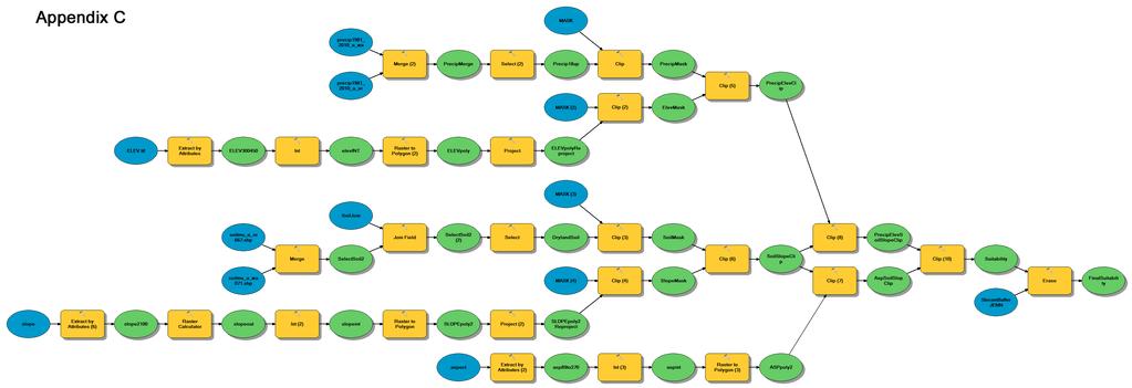
92
Research Proposal: Viticultural Terroir in Ashtabula County, Ohio
 Research Proposal: Viticultural Terroir in Ashtabula County, Ohio Prepared for: Applications in Cartography and Geographic Information Systems Prepared by: Paul Boehnlein, Undergraduate June 3, 2008 Summary
NZ GEOGRAPHICAL INDICATION (GI)
") NZ GEOGRAPHICAL INDICATION (GI) EXAMINATION CHECKSHEET Application information (reg 7) and formalities Box Reference Number 1 GI Number: 1021 GI Name: MATAKANA 2 New Zealand GI correctly selected (cf foreign)
NZ GEOGRAPHICAL INDICATION (GI) EXAMINATION CHECKSHEET Application information (reg 7) and formalities Box Reference Number 1 GI Number: 1021 GI Name: MATAKANA 2 New Zealand GI correctly selected (cf foreign)
1. Continuing the development and validation of mobile sensors. 3. Identifying and establishing variable rate management field trials
 Project Overview The overall goal of this project is to deliver the tools, techniques, and information for spatial data driven variable rate management in commercial vineyards. Identified 2016 Needs: 1.
NZ GEOGRAPHICAL INDICATION (GI)
") NZ GEOGRAPHICAL INDICATION (GI) EXAMINATION CHECKSHEET Application information (reg 7) and formalities Box Reference Number 1 GI Number: 1015 GI Name: WAIHEKE ISLAND 2 New Zealand GI correctly selected
NZ GEOGRAPHICAL INDICATION (GI) EXAMINATION CHECKSHEET Application information (reg 7) and formalities Box Reference Number 1 GI Number: 1015 GI Name: WAIHEKE ISLAND 2 New Zealand GI correctly selected
LAKE ONTARIO BEAMSVILLE BENCH VINEMOUNT RIDGE STATISTICS
 APPELLATION MAP Appellation Overview Diverse terroir, vine friendly micro climates, remarkably complex wines The Niagara Peninsula has the largest planted area of all viticulture areas in Canada. Situated
Monterey County Ranch Johnson Canyon Road Gonzales, CA Acres
 Monterey County Ranch 31701 Johnson Canyon Road Gonzales, CA 523.15 Acres Introduction Located in California s Central Coast in the heart of the Salinas Valley lies the Gallo family s Monterey County Ranch.
Vineyard Site Evaluation For: Beringer
 For: Location: 32720 SW Bell Rd, Sherwood OR 97140 T3S R2W Sec 11 Total Property Acreage: TL200 (39.7 acres), TL300 (19.84 acres), TL301 (59.99 acres) Gross Plantable Vineyard Acres (approximate): 90.0
Academic Year 2014/2015 Assessment Report. Bachelor of Science in Viticulture, Department of Viticulture and Enology
 Academic Year 2014/2015 Assessment Report Bachelor of Science in Viticulture, Department of Viticulture and Enology Due to changes in faculty assignments, there was no SOAP coordinator for the Department
World of Wine: From Grape to Glass
 World of Wine: From Grape to Glass Course Details No Prerequisites Required Course Dates Start Date: th 18 August 2016 0:00 AM UTC End Date: st 31 December 2018 0:00 AM UTC Time Commitment Between 2 to
96 of 100 DOCUMENTS FEDERAL REGISTER. 27 CFR Part 9. Napa Valley Viticultural Area. [TD ATF-79; Re: Notice No. 337] 46 FR 9061.
![96 of 100 DOCUMENTS FEDERAL REGISTER. 27 CFR Part 9. Napa Valley Viticultural Area. [TD ATF-79; Re: Notice No. 337] 46 FR 9061.](/thumbs/95/123569252.jpg "96 of 100 DOCUMENTS FEDERAL REGISTER. 27 CFR Part 9. Napa Valley Viticultural Area. [TD ATF-79; Re: Notice No. 337] 46 FR 9061.") Page 1 96 of 100 DOCUMENTS FEDERAL REGISTER 27 CFR Part 9 Napa Valley Viticultural Area [TD ATF-79; Re: Notice No. 337] January 28, 1981 ACTION: Final rule; Treasury decision. SUMMARY: This rule establishes
Page 1 96 of 100 DOCUMENTS FEDERAL REGISTER 27 CFR Part 9 Napa Valley Viticultural Area [TD ATF-79; Re: Notice No. 337] January 28, 1981 ACTION: Final rule; Treasury decision. SUMMARY: This rule establishes
Colorado State University Viticulture and Enology. Grapevine Cold Hardiness
 Colorado State University Viticulture and Enology Grapevine Cold Hardiness Grapevine cold hardiness is dependent on multiple independent variables such as variety and clone, shoot vigor, previous season
MBA 503 Final Project Guidelines and Rubric
 MBA 503 Final Project Guidelines and Rubric Overview There are two summative assessments for this course. For your first assessment, you will be objectively assessed by your completion of a series of MyAccountingLab
Geographic Information Systemystem
 Agenda Time 9:00:-9:20 9-20 9:50 9:50 10:00 Topic Intro to GIS/Mapping and GPS Applications for GIS in Vineyards Break Presenter Kelly Bobbitt, Mike Bobbitt and Associates Kelly Bobbitt, Mike Bobbitt and
Lesson 2 The Vineyard. From Soil to Harvest
 Lesson 2 The Vineyard From Soil to Harvest Objectives After reading this chapter, you should be able to display an understanding of how grapes are grown for wine production. describe the annual growing
is pleased to introduce the 2017 Scholarship Recipients
 is pleased to introduce the 2017 Scholarship Recipients Congratulations to Elizabeth Burzynski Katherine East Jaclyn Fiola Jerry Lin Sydney Morgan Maria Smith Jake Uretsky Elizabeth Burzynski Cornell University
JCAST. Department of Viticulture and Enology, B.S. in Viticulture
 JCAST Department of Viticulture and Enology, B.S. in Viticulture Student Outcomes Assessment Plan (SOAP) I. Mission Statement The mission of the Department of Viticulture and Enology at California State
World of Wine: From Grape to Glass Syllabus
 World of Wine: From Grape to Glass Syllabus COURSE OVERVIEW Have you always wanted to know more about how grapes are grown and wine is made? Perhaps you like a specific wine, but can t pinpoint the reason
Healthy Soils for a Sustainable Viticulture John Reganold
 Healthy Soils for a Sustainable Viticulture John Reganold Department of Crop & Soil Sciences Pullman, W Sustainable Viticulture Economically viable Environmentally sound Socially responsible QuickTime
INVESTIGATIONS INTO THE RELATIONSHIPS OF STRESS AND LEAF HEALTH OF THE GRAPEVINE (VITIS VINIFERA L.) ON GRAPE AND WINE QUALITIES
 ON GRAPE AND WINE QUALITIES") INVESTIGATIONS INTO THE RELATIONSHIPS OF STRESS AND LEAF HEALTH OF THE GRAPEVINE (VITIS VINIFERA L.) ON GRAPE AND WINE QUALITIES by Reuben Wells BAgrSc (Hons) Submitted in fulfilment of the requirements
INVESTIGATIONS INTO THE RELATIONSHIPS OF STRESS AND LEAF HEALTH OF THE GRAPEVINE (VITIS VINIFERA L.) ON GRAPE AND WINE QUALITIES by Reuben Wells BAgrSc (Hons) Submitted in fulfilment of the requirements
Reputation Tapping: Examining Consumer Response to Wine Appellation Information
 Reputation Tapping: Examining Consumer Response to Wine Appellation Information Brad Rickard, Assistant Professor Charles H. Dyson School of Applied Economics and Management Cornell University Presented
Winery Property in Niagara-on-the-Lake Vineyard/Production/Retail
 VIEW ONLINE Winery Property in Niagara-on-the-Lake Vineyard/Production/Retail Estate sale DeMoura Winery Way Property 545 Niagara Stone Road, Niagara-on-the-Lake, ON Asking Price: $1,700,000 > Gateway
Growing Cabernet Sauvignon at Wynns Coonawarra Estate
 Growing Cabernet Sauvignon at Wynns Coonawarra Estate The influence of vintage, clones and site Ben Harris Vineyard Manager Wynns Coonawarra Estate Coonawarra Red and White Winegrape Varieties Red (90%)
HSC Geography. Year 2016 Mark Pages 30 Published Feb 7, Geography Notes. By Annabelle (97.35 ATAR)
") HSC Geography Year 2016 Mark 93.00 Pages 30 Published Feb 7, 2017 Geography Notes By Annabelle (97.35 ATAR) Powered by TCPDF (www.tcpdf.org) Your notes author, Annabelle. Annabelle achieved an ATAR of
HSC Geography Year 2016 Mark 93.00 Pages 30 Published Feb 7, 2017 Geography Notes By Annabelle (97.35 ATAR) Powered by TCPDF (www.tcpdf.org) Your notes author, Annabelle. Annabelle achieved an ATAR of
Fleurieu zone (other)
") Fleurieu zone (other) Incorporating Southern Fleurieu and Kangaroo Island wine regions, as well as the remainder of the Fleurieu zone outside all GI regions Regional summary report 2006 South Australian
Fleurieu zone (other) Incorporating Southern Fleurieu and Kangaroo Island wine regions, as well as the remainder of the Fleurieu zone outside all GI regions Regional summary report 2006 South Australian
Peach and Nectarine Cork Spot: A Review of the 1998 Season
 Peach and Nectarine Cork Spot: A Review of the 1998 Season Kevin R. Day Tree Fruit Farm Advisor Tulare County University of California Cooperative Extension Along with many other problems, fruit corking
The Implications of Climate Change for the Ontario Wine Industry
 The Implications of Climate Change for the Ontario Wine Industry Tony B. Shaw Department of Geography and Cool Climate Oenology and Viticulture Institute Brock University Climate Change Most scientists
Réseau Vinicole Européen R&D d'excellence
 Réseau Vinicole Européen R&D d'excellence Lien de la Vigne / Vinelink 1 Paris, 09th March 2012 R&D is strategic for the sustainable competitiveness of the EU wine sector However R&D focus and investment
Napa County Planning Commission Board Agenda Letter
 Agenda Date: 7/1/2015 Agenda Placement: 10A Continued From: May 20, 2015 Napa County Planning Commission Board Agenda Letter TO: FROM: Napa County Planning Commission John McDowell for David Morrison -
SPATIAL ANALYSIS OF WINERY CONTAMINATION
 SPATIAL ANALYSIS OF WINERY CONTAMINATION The Spatial Analysis of Winery Contamination project used a previously created MS Access database to create a personal geodatabase within ArcGIS in order to perform
Joseph A. Fiola, Ph.D. Specialist in Viticulture and Small Fruit Western MD Research & Education Center Keedysville Road Keedysville, MD
 Joseph A. Fiola, Ph.D. Specialist in Viticulture and Small Fruit Western MD Research & Education Center 18330 Keedysville Road Keedysville, MD 21756-1104 301-432-2767 ext. 344; Fax 301-432-4089 jfiola@umd.edu
APPENDIX C - NRCS PRIME FARMLAND REPORT
 APPENDIX C - NRCS PRIME FARMLAND REPORT June 2007 Page 51 Parks, Trails, and Open Space Plan Page 52 Payson City- East Side Comprehensive Plan FARMLAND CLASSIFICATION RATING FOR UTAH COUNTY, UTAH - CENTRAL
Washington Vineyard Acreage Report: 2011
 Washington Vineyard Acreage Report: 2011 COMPILED BY USDA/NATIONAL AGRICULTURAL STATISTICS SERVICE WASHINGTON FIELD OFFICE DAVID KNOPF, DIRECTOR DENNIS KOONG, DEPUTY DIRECTOR P. O. BOX 609 OLYMPIA, WASHINGTON
Supply & Demand for Lake County Wine Grapes. Christian Miller Lake County MOMENTUM April 13, 2015
 Supply & Demand for Lake County Wine Grapes Christian Miller Lake County MOMENTUM April 13, 2015 About Full Glass Research Provider of economic, market & industry research to food & drink companies and
Structures of Life. Investigation 1: Origin of Seeds. Big Question: 3 rd Science Notebook. Name:
 3 rd Science Notebook Structures of Life Investigation 1: Origin of Seeds Name: Big Question: What are the properties of seeds and how does water affect them? 1 Alignment with New York State Science Standards
The University Wine Course: A Wine Appreciation Text & Self Tutorial PDF
 The University Wine Course: A Wine Appreciation Text & Self Tutorial PDF For over 20 years the most widely used wine textbook in higher education courses, The University Wine Course provides a 12-week
The Economic Impact of Wine and Grapes in Lodi 2009
 The Economic Impact of Wine and Grapes in Lodi 2009 Prepared for the Lodi District Grape Growers Association and the Lodi Winegrape Commission May 2009 A S T O N E B R I D G E R E S E A R C H R E P O R
Washington Wine Commission: Wine industry grows its research commitment
 PROGRESS EDITION MARCH 22, 2016 10:33 PM Washington Wine Commission: Wine industry grows its research commitment HIGHLIGHTS New WSU Wine Science Center a significant step up for industry Development of
FOH WINE AND BEER KNOWLEDGE LESSON WEEK TWO
 FOH WINE AND BEER KNOWLEDGE LESSON WEEK TWO This week, we're going to go over some wine basics and skip the beer. Most of the information here is from Kevin Zraly s Windows on the World Complete Wine Course.
As winegrowers we believe that wine is primarily grown in the vineyard.
 As winegrowers we believe that wine is primarily grown in the vineyard. The health of our vineyard and the ecosystems that surround them are the ultimate determiners of wine quality. We operate our vineyards
Pepper Bridge Winery AMAVI CELLARS
 Born of Fire and Ice Pepper Born of Fire and Ice Pepper Washington State s AVA s produce 18 premium wine varietals tons split about equally between 9 red and 9 white types. Overall Growth has averaged
Grape Growers of Ontario Developing key measures to critically look at the grape and wine industry
 Grape Growers of Ontario Developing key measures to critically look at the grape and wine industry March 2012 Background and scope of the project Background The Grape Growers of Ontario GGO is looking
Organic and Sustainable Winegrowing
 History & Winemaking Coming from a small town in California s Central Valley, Dan Morgan Lee had prepared initially for the study of veterinary medicine at the University of California, Davis. It was late
Proposal for the Approval of a New Subdivision of the. Okanagan Valley Geographical Indication NARAMATA BENCH SUB-GI.
 Proposal for the Approval of a New Subdivision of the Okanagan Valley Geographical Indication NARAMATA BENCH SUB-GI 23 April 2018 Prepared by the Sub-GI Committee, Naramata Bench Introduction This document
ECONOMIC IMPACT OF WINE AND VINEYARDS IN NAPA COUNTY
 ECONOMIC IMPACT OF WINE AND VINEYARDS IN NAPA COUNTY An Report prepared for Jack L. Davies Napa Valley Agricultural Land Preservation Fund and Napa Valley Vintners JUNE 2005 FULL ECONOMIC IMPACT OF WINE
BREWERS ASSOCIATION CRAFT BREWER DEFINITION UPDATE FREQUENTLY ASKED QUESTIONS. December 18, 2018
 BREWERS ASSOCIATION CRAFT BREWER DEFINITION UPDATE FREQUENTLY ASKED QUESTIONS December 18, 2018 What is the new definition? An American craft brewer is a small and independent brewer. Small: Annual production
Erosion Hazard (Off-Road, Off-Trail) Angelina County, Texas (Upland Island Erosion Hazard (Off-Road, Off-Trail))
 Angelina County, Texas (Upland Island Erosion Hazard (Off-Road, Off-Trail))") Cypress Creek Erosion Hazard (Off-Road, Off-Trail) Angelina County, Texas () 31 7' 50'' 31 4' 50'' 3439500 3440400 3441300 3442200 3443100 3444000 3444900 94 24' 48'' 94 24' 51'' 365700 Graham Creek 365700
Cypress Creek Erosion Hazard (Off-Road, Off-Trail) Angelina County, Texas () 31 7' 50'' 31 4' 50'' 3439500 3440400 3441300 3442200 3443100 3444000 3444900 94 24' 48'' 94 24' 51'' 365700 Graham Creek 365700
GLOSSARY Last Updated: 10/17/ KL. Terms and Definitions
 GLOSSARY Last Updated: 10/17/2017 - KL Terms and Definitions Spacing 4ETa Zone(s) Background Drill Elevation Climate Soil Ecoregion 4 Recommended base spacing between containerized, cutting, plug or sprig
RESOLUTION OIV-ECO
 RESOLUTION OIV-ECO 563-2016 TRAINING PROGRAMS FOR OENOLOGISTS THE GENERAL ASSEMBLY, based on the work of the FORMAT Expert Group, CONSIDERING the resolution OIV-ECO 492-2013 providing the definition of
RETAIL INVESTMENT GROUP, LLC
 RETAIL INVESTMENT GROUP, LLC 3704 FRUITVALE BLVD YAKIMA, WA 98902 $3,135,000 CAP: 5.00% ACTUAL SITE INVESTMENT SUMMARY PRICE: $3,135,000 CAP: 5.00% PROPERTY INFORMATION INVESTMENT HIGHLIGHTS Address: 3704
Macroclimate in New York and Site Suitability
 Statewide Viticulture Extension Tim Martinson Tel: 315 787-2448 Dept. Horticultural Sciences Fax: 315-787-2216 NYS Agric. Exper. Station E-mail: tem2@cornell.edu 106 Hedrick Hall 630 West North Street,
2018 CONVENTION & TRADE SHOW CALL FOR POSTERS & ORAL PRESENTATIONS
 2018 CONVENTION & TRADE SHOW CALL FOR POSTERS & ORAL PRESENTATIONS ABOUT WINEGROWERS CONVENTION The Washington Winegrowers Association is the place for the wine and grape industry to network and learn,
EFFECT OF TOMATO GENETIC VARIATION ON LYE PEELING EFFICACY TOMATO SOLUTIONS JIM AND ADAM DICK SUMMARY
 EFFECT OF TOMATO GENETIC VARIATION ON LYE PEELING EFFICACY TOMATO SOLUTIONS JIM AND ADAM DICK 2013 SUMMARY Several breeding lines and hybrids were peeled in an 18% lye solution using an exposure time of
BLUEBERRY MUFFIN APPLICATION RESEARCH COMPARING THE FUNCTIONALITY OF EGGS TO EGG REPLACERS IN BLUEBERRY MUFFIN FORMULATIONS RESEARCH SUMMARY
 BLUEBERRY MUFFIN APPLICATION RESEARCH COMPARING THE FUNCTIONALITY OF EGGS TO EGG REPLACERS IN BLUEBERRY MUFFIN FORMULATIONS RESEARCH SUMMARY BLUEBERRY MUFFIN RESEARCH EXECUTIVE SUMMARY For this study,
Climate Change and Wine
 Gregory V. Jones Director: Center for Wine Education Chair: Wine Studies Professor: Environmental Studies 26-27 November, 2018 Amsterdam, Netherlands The global wine map is changing Climate change is
Grower Summary TF 170. Plums: To determine the performance of 6 new plum varieties. Annual 2012
 Grower Summary TF 170 Plums: To determine the performance of 6 new plum varieties Annual 2012 Disclaimer AHDB, operating through its HDC division seeks to ensure that the information contained within this
Introduction to the Practical Exam Stage 1. Presented by Amy Christine MW, DC Flynt MW, Adam Lapierre MW, Peter Marks MW
 Introduction to the Practical Exam Stage 1 Presented by Amy Christine MW, DC Flynt MW, Adam Lapierre MW, Peter Marks MW 2 Agenda Exam Structure How MW Practical Differs from Other Exams What You Must Know
Washington State Wine 101
 Washington State Wine 101 Washington 2 nd Largest Producer in US Washington State produces: Premium wines of superior quality Range of varieties Distinctive character Unique balance of Old World and New
Suitability for Haul Roads (MI) Macomb County, Michigan, and Oakland County, Michigan (River Bends Park, West Side, Shelby Twp.)
 Macomb County, Michigan, and Oakland County, Michigan (River Bends Park, West Side, Shelby Twp.)") Suitability for Haul Roads (MI) Macomb, and Oakland () MAP LEGEND Area of Interest () Soils Soil Ratings Area of Interest () Soil Map Units Poorly suited Moderately suited Well suited Political Features
Suitability for Haul Roads (MI) Macomb, and Oakland () MAP LEGEND Area of Interest () Soils Soil Ratings Area of Interest () Soil Map Units Poorly suited Moderately suited Well suited Political Features
Advancing Agriculture Grape Industry Development Program
 2017-2018 Advancing Agriculture Grape Industry Development Program 1) Objectives: To provide assistance for the establishment of new or more productive vineyards. To assist with the adoption of new technologies
Emerging Local Food Systems in the Caribbean and Southern USA July 6, 2014
 Consumers attitudes toward consumption of two different types of juice beverages based on country of origin (local vs. imported) Presented at Emerging Local Food Systems in the Caribbean and Southern USA
Erosion Hazard (Road, Trail) Angelina County, Texas (Upland Island Erosion Hazard (Road, Trail)) Web Soil Survey National Cooperative Soil Survey
 Angelina County, Texas (Upland Island Erosion Hazard (Road, Trail)) Web Soil Survey National Cooperative Soil Survey") Cypress Creek Erosion Hazard (Road, Trail) Angelina County, Texas () 31 7' 50'' 31 4' 50'' 3439500 3440400 3441300 3442200 3443100 3444000 3444900 94 24' 48'' 94 24' 51'' 365700 Graham Creek 365700 366600
Cypress Creek Erosion Hazard (Road, Trail) Angelina County, Texas () 31 7' 50'' 31 4' 50'' 3439500 3440400 3441300 3442200 3443100 3444000 3444900 94 24' 48'' 94 24' 51'' 365700 Graham Creek 365700 366600
Fungicides for phoma control in winter oilseed rape
 October 2016 Fungicides for phoma control in winter oilseed rape Summary of AHDB Cereals & Oilseeds fungicide project 2010-2014 (RD-2007-3457) and 2015-2016 (214-0006) While the Agriculture and Horticulture
2012 BUD SURVIVAL SURVEY IN NIAGARA & ESSEX AREA VINEYARDS
 BUD SURVIVAL SURVEY IN NIAGARA & ESSEX AREA VINEYARDS Prepared for: The Grape Growers of Ontario KCMS - Applied Research and Consulting 1215 Maple St. Box#13 Fenwick, Ontario L0S 1C0 Telephone: (905) 892-7050
OF THE VARIOUS DECIDUOUS and
 (9) PLAXICO, JAMES S. 1955. PROBLEMS OF FACTOR-PRODUCT AGGRE- GATION IN COBB-DOUGLAS VALUE PRODUCTIVITY ANALYSIS. JOUR. FARM ECON. 37: 644-675, ILLUS. (10) SCHICKELE, RAINER. 1941. EFFECT OF TENURE SYSTEMS
Vintage 2006: Umpqua Valley Reference Vineyard Report
 Vintage 2006: Umpqua Valley Reference Vineyard Report Summary: The 2006 vintage started off slow with a cool, wet spring and was followed by a largely climatically favorable growing season. The summer
A Climate for Sauvignon Blanc: Lake County
 A Climate for Sauvignon Blanc: Lake County Viala et al (1901) Traite General de Viticulture Gregory V. Jones Director: Center for Wine Education Professor: Wine Studies & Environmental Studies Lake County,
Final Report. TITLE: Developing Methods for Use of Own-rooted Vitis vinifera Vines in Michigan Vineyards
 Final Report TITLE: Developing Methods for Use of Own-rooted Vitis vinifera Vines in Michigan Vineyards PRINCIPAL INVESTIGATOR: Thomas J. Zabadal OBJECTIVES: (1) To determine the ability to culture varieties
Work Sample (Minimum) for 10-K Integration Assignment MAN and for suppliers of raw materials and services that the Company relies on.
 for 10-K Integration Assignment MAN and for suppliers of raw materials and services that the Company relies on.") Work Sample (Minimum) for 10-K Integration Assignment MAN 4720 Employee Name: Your name goes here Company: Starbucks Date of Your Report: Date of 10-K: PESTEL 1. Political: Pg. 5 The Company supports the
Work Sample (Minimum) for 10-K Integration Assignment MAN 4720 Employee Name: Your name goes here Company: Starbucks Date of Your Report: Date of 10-K: PESTEL 1. Political: Pg. 5 The Company supports the
GI Protection in Europe
 GI Protection in Europe Product approach Currently 4 kinds of goods can be protected under the EU quality schemes: Wines (Regulation 1308/2013) Aromatized wines (Regulation 251/2014) Spirit drinks (Regulation
The 2006 Economic Impact of Nebraska Wineries and Grape Growers
 A Bureau of Business Economic Impact Analysis From the University of Nebraska Lincoln The 2006 Economic Impact of Nebraska Wineries and Grape Growers Dr. Eric Thompson Seth Freudenburg Prepared for The
Wine-Tasting by Numbers: Using Binary Logistic Regression to Reveal the Preferences of Experts
 Wine-Tasting by Numbers: Using Binary Logistic Regression to Reveal the Preferences of Experts When you need to understand situations that seem to defy data analysis, you may be able to use techniques
Non-GMO Project Trademark Use Guide
 Non-GMO Project Trademark Use Guide Table of Contents Introduction.... 3 General Use Guidelines.... 5 Design Specifications.... 6 Non-GMO Project Verified Mark (English).... 7 Non-GMO Project Bilingual
Salem Cider Convention
 Tim Larsen 277 S Ward Ave East Wenatchee, WA 98802 Phone: 509.885.2734 E-Mail: larsenrud@gmail.com Web: SnowdriftCider.com Salem Cider Convention Report on Federal Regulations Concerning Cider February
Regional Identity and the Reputation of Willamette Valley Wines: A Multiple Stakeholder Assessment
 Linfield College DigitalCommons@Linfield 2012 Projects Keck Summer Collaborative Research Projects 7-25-2012 Regional Identity and the Reputation of Willamette Valley Wines: A Multiple Stakeholder Assessment
The Roles of Social Media and Expert Reviews in the Market for High-End Goods: An Example Using Bordeaux and California Wines
 The Roles of Social Media and Expert Reviews in the Market for High-End Goods: An Example Using Bordeaux and California Wines Alex Albright, Stanford/Harvard University Peter Pedroni, Williams College
T he M yths of Terroir. K evin R. Pogue PhD Department of Geology Whitman College
 T he M yths of Terroir K evin R. Pogue PhD Department of Geology Whitman College Myth #1 Terroir is a French concept that is untranslatable. Corollary: Since it can t be translated, we can just create
Coffee weather report November 10, 2017.
 Coffee weather report November 10, 2017. awhere, Inc., an agricultural intelligence company, is pleased to provide this map-and-chart heavy report focused on the current coffee crop in Brazil. Global stocks
RESULTS OF THE MARKETING SURVEY ON DRINKING BEER
 Uri Dahahn Business and Economic Consultants RESULTS OF THE MARKETING SURVEY ON DRINKING BEER Uri Dahan Business and Economic Consultants Smith - Consulting & Reserch ltd Tel. 972-77-7032332, Fax. 972-2-6790162,
The Napa Valley is a wine growing gregion with many appellations. Napa received its own AVA designation in 1981 making
 The Napa Valley is a wine growing gregion with many appellations Each appellation has its own unique microclimate and soil type, making it more suited to different varietals Napa received its own AVA designation
DETERMINANTS OF DINER RESPONSE TO ORIENTAL CUISINE IN SPECIALITY RESTAURANTS AND SELECTED CLASSIFIED HOTELS IN NAIROBI COUNTY, KENYA
 DETERMINANTS OF DINER RESPONSE TO ORIENTAL CUISINE IN SPECIALITY RESTAURANTS AND SELECTED CLASSIFIED HOTELS IN NAIROBI COUNTY, KENYA NYAKIRA NORAH EILEEN (B.ED ARTS) T 129/12132/2009 A RESEACH PROPOSAL
L I N D E M A N N. Young Almonds Excellent Production Potential Madera County Acres P R O P E R T I E S I N C.
 L I N D E M A N N Young Almonds Excellent Production Potential Madera County 19.11+- Acres P R O P E R T I E S I N C. 3734 W. Spruce Ave Fresno, CA 93711 TEL-559-479-1658 FAX-559-827-4077 Young Almonds
Big Data and the Productivity Challenge for Wine Grapes. Nick Dokoozlian Agricultural Outlook Forum February
 Big Data and the Productivity Challenge for Wine Grapes Nick Dokoozlian Agricultural Outlook Forum February 2016 0 Big Data and the Productivity Challenge for Wine Grapes Outline Current production challenges
Varieties and Rootstocks in Texas
 Varieties and Rootstocks in Texas Pierre Helwi, Ph.D Extension Viticulture Specialist Texas A&M AgriLife Extension Service Grape Camp November 05, 2017 Characteristics of Major Types of Grapes Type Fruit
The aim of the thesis is to determine the economic efficiency of production factors utilization in S.C. AGROINDUSTRIALA BUCIUM S.A.
 The aim of the thesis is to determine the economic efficiency of production factors utilization in S.C. AGROINDUSTRIALA BUCIUM S.A. The research objectives are: to study the history and importance of grape
Conjunctive Labeling: What and Why? Mendocino County Conjunctive Labeling Educational Forum November 29, 2018
 Conjunctive Labeling: What and Why? Mendocino County Conjunctive Labeling Educational Forum November 29, 2018 Christian Miller Proprietor, Full Glass Research What is Conjunctive Labeling? ücommon Definition:
Identifying Climate Suitability for Oregon White Oak
 Introduction Identifying Climate Suitability for Oregon White Oak Lucas Rabins, Ben Larson, & Anders Dowell December 2016 As the earth s climate changes over the next century, many species adapted to specific
Sustainable Coffee Challenge FAQ
 Sustainable Coffee Challenge FAQ What is the Sustainable Coffee Challenge? The Sustainable Coffee Challenge is a pre-competitive collaboration of partners working across the coffee sector, united in developing
Ohio Grape-Wine Electronic Newsletter
 Ohio Grape-Wine Electronic Newsletter Imed Dami, Associate Professor and Extension Viticulturist Department of Horticulture and Crop Science Ohio Agricultural Research and Development Center 1680 Madison
GEOGRAPHICAL INDICATIONS SYSTEM IN THE EUROPEAN UNION
 GEOGRAPHICAL INDICATIONS SYSTEM IN THE EUROPEAN UNION EU India IP Cooperation Specialised Training on GIs India, December 2016 Aitor Pomares Attorney-at-Law 1. Overview of the EU s GI system 2. Registration
Shaping the Future: Production and Market Challenges
 Call for Papers Dear Sir/Madam At the invitation of the Ministry of Stockbreeding, Agriculture, and Fisheries of the Oriental Republic of Uruguay, the 41th World Congress of Vine and Wine and the 16 th
Notes on the Philadelphia Fed s Real-Time Data Set for Macroeconomists (RTDSM) Capacity Utilization. Last Updated: December 21, 2016
 Capacity Utilization. Last Updated: December 21, 2016") 1 Notes on the Philadelphia Fed s Real-Time Data Set for Macroeconomists (RTDSM) Capacity Utilization Last Updated: December 21, 2016 I. General Comments This file provides documentation for the Philadelphia
1 Notes on the Philadelphia Fed s Real-Time Data Set for Macroeconomists (RTDSM) Capacity Utilization Last Updated: December 21, 2016 I. General Comments This file provides documentation for the Philadelphia
SPLENDID SOIL (1 Hour) Addresses NGSS Level of Difficulty: 2 Grade Range: K-2
 Addresses NGSS Level of Difficulty: 2 Grade Range: K-2") (1 Hour) Addresses NGSS Level of Difficulty: 2 Grade Range: K-2 OVERVIEW In this activity, students will examine the physical characteristics of materials that make up soil. Then, they will observe the
(1 Hour) Addresses NGSS Level of Difficulty: 2 Grade Range: K-2 OVERVIEW In this activity, students will examine the physical characteristics of materials that make up soil. Then, they will observe the
Do lower yields on the vine always make for better wine?
 Grape and wine quality Increasing quality Do lower yields on the vine always make for better wine? Nick Dokoozlian Viticulture, & Enology E&J Gallo ry Do lower yields on the vine always make for better
HARVEST & POST-HARVEST PRACTICES. Harvest Fermentation Drying Micro-fermentation HARVESTING FERMENTATION
 HARVEST & POST-HARVEST PRACTICES Harvest Fermentation Drying Micro-fermentation Information for this chapter is taken from CAOBISCO/ECA/FCC Cocoa Beans: Chocolate and Cocoa Industry Quality Requirements.
VineAlert An Economic Impact Analysis
 VineAlert An Economic Impact Analysis Goodman School of Business Consulting Group Goodman School of Business Cairns Complex Room 209A 500 Glenridge Ave. St. Cathararines, ON L2S-3A1 905-688-5550 Ext. 5104
DRAFT SECTION 4(F) EVALUATION FAIRVIEW CEMETERY
 EVALUATION FAIRVIEW CEMETERY") DRAFT SECTION 4(F) EVALUATION I. DESCRIPTION OF SECTION 4(F) RESOURCE The Section 4(f) resource that could be affected by the proposed action is Fairview Cemetery. The proposed action would require the
DRAFT SECTION 4(F) EVALUATION I. DESCRIPTION OF SECTION 4(F) RESOURCE The Section 4(f) resource that could be affected by the proposed action is Fairview Cemetery. The proposed action would require the
COLORADO REVISED STATUTES, TITLE 35, AGRICULTURE
 COLORADO REVISED STATUTES, TITLE 35, AGRICULTURE ARTICLE 29.5: COLORADO WINE INDUSTRY DEVELOPMENT ACT Section 35-29.5-101. Short title. 35-29.5-101.5. Legislative declaration. 35-29.5-102. Definitions.
Development of a Master Class Curriculum on Wines of Nova Scotia
 Request for Proposals for Development of a Master Class Curriculum on Wines of Nova Scotia RFP Number: 18-001 Issued By: Canadian Association of Professional Sommeliers Atlantic Chapter (CAPS-AC) Representative:
Project Concluding: Summary Report Mandarin Trial for the California Desert
 Project Concluding: Summary Report Mandarin Trial for the California Desert Peggy A. Mauk UC Cooperative Extension, Riverside County Tracy L. Kahn Botany and Plant Sciences, UC/Riverside Mandarin production
Food Allergies on the Rise in American Children
 Transcript Details This is a transcript of an educational program accessible on the ReachMD network. Details about the program and additional media formats for the program are accessible by visiting: https://reachmd.com/programs/hot-topics-in-allergy/food-allergies-on-the-rise-in-americanchildren/3832/