An Ecologically Annotated Checklist of the Vascular Flora at the Chesapeake Bay Center for Field Biology, with Keys
|
|
|
- Shanon Garrison
- 5 years ago
- Views:
Transcription
1 Smithsonian Environmental Research Center Smithsonian Institution Scholarly Press An Ecologically Annotated Checklist of the Vascular Flora at the Chesapeake Bay Center for Field Biology, with Keys As part of the fiftieth anniversary celebration of the Smithsonian Environmental Research Center (SERC), this first-known SERC publication has been updated by editors Dennis Whigham, Geoffrey Parker, and Olav Oftedal and is reprinted with support from the Smithsonian s Atherton Seidell Grant Program for the Dissemination of Previously Published Scientific Research. Higman In May 1968, botanist Daniel Higman published An Ecologically Annotated Checklist of the Vascular Flora at the Chesapeake Bay Center for Field Biology, with Keys through the Smithsonian Institution s Office of Ecology. Henceforth referred to as The Flora, it was based on Higman s exploration of plant species found on three tracts of Smithsonian-owned land near the Chesapeake Bay in Maryland known as Java Farm, Corn Island, and Ivy Neck, which together represent a broad spectrum of ecological systems. An Ecologically Annotated Checklist of the Vascular Flora at the Chesapeake Bay Center for Field Biology, with Keys Daniel Higman Edited by Dennis Whigham, Geoffrey Parker, and Olav Oftedal ISBN (online): ISBN (print): Available for download at Open SI ( Smithsonian Institution Scholarly Press UPDATED EDITION
2
3 An Ecologically Annotated Checklist of the Vascular Flora at the Chesapeake Bay Center for Field Biology, with Keys Updated Edition
4
5 An Ecologically Annotated Checklist of the Vascular Flora at the Chesapeake Bay Center for Field Biology, with Keys DANIEL HIGMAN Updated Edition EDITED BY DENNIS WHIGHAM, GEOFFREY PARKER, AND OLAV OFTEDAL Smithsonian Environmental Research Center Smithsonian Institution Scholarly Press WASHINGTON, D.C. 2016
6 Originally published by the Smithsonian Institution s Office of Ecology in May Updated by the editors for the Smithsonian Environmental Research Center in July Published by SMITHSONIAN INSTITUTION SCHOLARLY PRESS P.O. Box 37012, MRC 957 Washington, D.C Cover photo: Taking Back the Land by A. Mark Haddon. A successional forest slowly reclaims an eighteenth-century carriage road on Smithsonian Environmental Research Center (SERC) property. The trail is now used by SERC scientists for access to research areas. Back cover photo: Detail from aerial image taken 24 July 1960 of SERC site and adjacent lands and waterways; courtesy of SERC. Use of materials in this publication is permitted for personal, educational, or noncommercial purposes. Users must cite author and source of content and must comply with all other terms or restrictions that may be applicable. Users are responsible for securing permission from a rights holder for any other uses. ISBN (digital): ISBN (print): Publication date (online): 6 May 2016 c The paper used in this publication meets the minimum requirements of the American National Standard for Permanence of Paper for Printed Library Materials Z
7 Contents LIST OF FIGURES LIST OF TABLES PREFACE TO THE UPDATED EDITION ACKNOWLEDGMENTS vi vii ix x INTRODUCTION 1 Physical Environment of the Chesapeake Bay Center 3 History of Vegetation and Land Use 8 Present Vegetation Types 10 STRUCTURE OF THE CHECKLIST AND KEYS 33 Nomenclature 34 Annotations 35 Hectare Coordinates of the Chesapeake Bay Center for Field Biology 36 Literature Cited 39 Families Represented at the Chesapeake Bay Center for Field Biology 40 Adventive and Introduced Species at the Chesapeake Bay Center 42 PLANT ANNOTATIONS (TAXONOMY AND LOCATIONAL INFORMATION) 45 APPENDIX I: Additional Species Collected at the Chesapeake Bay Center for Field Biology during the Preparation of This Checklist 225 APPENDIX II: Additional Annotations for Species in This Checklist 229 APPENDIX III: Common Names of Plants at the Chesapeake Bay Center, Local to That Vicinity 233 APPENDIX IV: New Plant Species Found after Original Publication of Higman s Checklist 235
8 List of Figures 1. Vicinity map 2 2. Java Farm soil map 5 3. Ivy Neck soil map 7 4. Java Farm vegetation map Ivy Neck vegetation map Java Farm hectare map Ivy Neck hectare map 38 vi
9 List of Tables Table I. Comparative composition of vegetation types at Java Farm and Ivy Neck 16 Families represented at the Chesapeake Bay Center for Field Biology 40 Adventive and Introduced Species at the Chesapeake Bay Center 42 Appendix IV. New Plant Species Found after Original Publication of Higman s Checklist 235 vii
10
11 Preface to the Updated Edition As part of the fiftieth anniversary celebration of the Smithsonian Environmental Research Center (SERC), it is appropriate to update and reprint the first known SERC publication. In May 1968, botanist Daniel Higman published An Ecologically Annotated Checklist of the Vascular Flora at the Chesapeake Bay Center for Field Biology, with Keys through the Smithsonian s Office of Ecology. The document, henceforth referred to as The Flora, was based on Higman s exploration of plant species found on three tracts of land owned by the Smithsonian: Java Farm, Corn Island, and Ivy Neck. Plants collected during Higman s study became the foundation of the current small herbarium at SERC, and duplicate specimens were placed in the herbarium at the National Museum of Natural History s Botany Department. Since its release, The Flora has been a valuable resource for botanists and plant ecologists working at SERC. Over the years, the number of copies according to Higman, only 100 copies were printed has naturally decreased. The copies that remain in use at SERC have become worn and deteriorated. In 2013, SERC was awarded a grant through the Smithsonian s Atherton Seidell Grant Program for the Dissemination of Previously Published Scientific Research to update and reprint The Flora and make it available online in a digital format, with a limited number of print copies distributed to libraries and repositories within and outside the Smithsonian. The updated edition retains the taxonomic and common names as they appeared in the original document and also provides current names of species, genera, and families. Where an updated name is included, it appears in bold. Any outdated taxonomic and common names appear in parentheses after the current accepted names. We consulted the most current and reliable resources for plant taxonomy and nomenclature: Flora of Virginia Project ( USDA s PLANTS Database ( and Kew Gardens The Plant List ( The USDA and Kew websites provided the current acceptable taxonomic nomenclature for species identified by Higman. To ensure consistency, a decision was made to use taxonomic names in the PLANTS Database. In keeping with the Seidell guidelines, no changes were made in the taxonomic ix
12 keys that appear in The Flora, thus the keys may refer to prior taxonomic names that now appear in parentheses. Changes to the publication are limited to digitalizing and updating maps, a new plant species appendix, and this preface. In addition to editors Oftedal and Whigham, contributions to the appendix were provided by Jay O Neill, John Parker, and Jessica Shue. Acknowledgments We especially thank Heather Soulen for moving away from her estuarine animal background to lend her skills to the task of identifying the current taxonomic nomenclature for species found in the original publication, creating GIS maps, designing the framework used to produce the revision, and creating an online searchable database using the revised edition. We thank Heather Soulen and Kristen Minogue for linking the original and revised documents to the SERC website. The efforts of Meghan Williams, working with and directing Heather in map creation using SERC s GIS facilities, is most appreciated. Finally, we thank the Smithsonian committee that provided the funding for the project through the Atherton Seidell Grant program. We are especially pleased that the funding enabled us to reproduce the first SERC publication during the year celebrating fifty years of research at the Smithsonian Environmental Research Center. Dennis Whigham, Senior Botanist and Principal Investigator Geoffrey G. Parker, Forest Ecologist Olav T. Oftedal, Emeritus Scientist Smithsonian Environmental Research Center 647 Contees Wharf Road Edgewater, Maryland USA x PREFACE TO THE UPDATED EDITION
13 An Ecologically Annotated Checklist of the Vascular Flora at the Chesapeake Bay Center for Field Biology, with Keys Updated Edition
14
15 Introduction The 690 acres of land owned by the Smithsonian Institution at the Chesapeake Bay Center for Field Biology lie on the west shore of the Bay in Anne Arundel County, Maryland, approximately 7 miles south of Annapolis and 30 miles east of Washington, D. C. The Center consists of three tracts: Java Farm, Corn Island, and the southern part of Ivy Neck peninsula (referred to herein simply as Ivy Neck). The topographic map (Figure 1) shows their relationship. Java Farm and Corn Island lie on Rhode River, on opposite sides of Muddy Creek estuary. Ivy Neck lies on West River. The topography of the Center ranges from rolling upland at Java Farm to nearly level lowland at Ivy Neck. There is also much variation in the soils and drainage. The vegetation includes extensive areas of hardwood forest, abandoned fields and pastures, and coastal salt marsh. Ivy Neck also contains cultivated fields and sandy beach areas. Thus the Center presents a broad spectrum of ecological systems. The Smithsonian Institution recently acquired the land, and in 1966 established a consortium with The Johns Hopkins University and the University of Maryland for a cooperative program of ecological research. One of the first projects at the Center has been a survey of the vascular flora and the preparation of an ecologically annotated checklist with artificial keys. This checklist provides basic information required in the planning of future projects. The floristic survey has concentrated on the areas of Java Farm and Ivy Neck, with less comprehensive coverage of Corn Island. The reason for this restriction is that the previous owner of the island is still in residence there, and much of the vegetation is subject to slight disturbance. Part of the island has been landscaped and a grass turf is maintained. The chestnut oak forest vegetation on the rest of the island resembles that of Hog Island, which is part of Java Farm. As background information the physical environment, history of land use, and present vegetation at the Center are presented in the first part of this introduction. The second part will explain the checklist, the format of its keys, and the ecological annotations which accompany each entry. 1

16 Figure 1. 2 ANNOTATED CHECKLIST OF THE VASCULAR FLORA AT THE CHESAPEAKE BAY CENTER FOR FIELD BIOLOGY
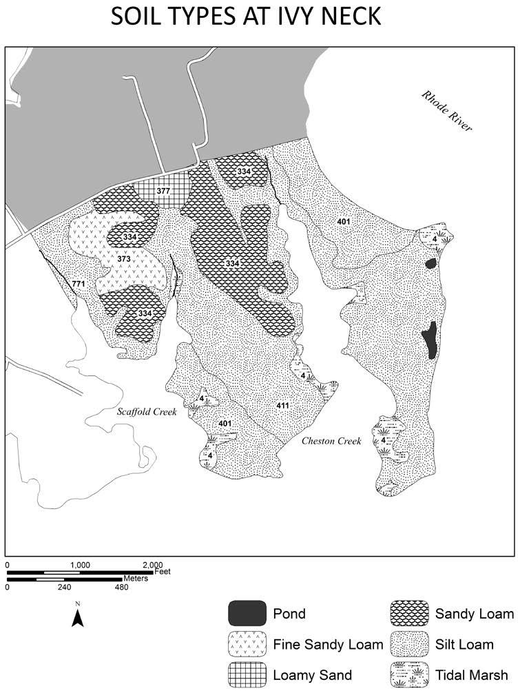
17 Physical Environment of the Chesapeake Bay Center The physiography of the Center ranges from rolling upland at Java Farm to gently south- sloping lowland at Ivy Neck. Java Farm has two steep north- south ridges near the headquarters area, of which the taller has an elevation of 100 feet. Elsewhere, the elevation averages 20 to 60 feet. Moderately steep forested slopes occur in all directions. The Farm lies at the mouth of the watershed of Muddy Creek, and is drained by the north fork of this creek and by several springs. Although most of the farm is well drained, one abandoned pasture is vernally inundated until May or June. Muddy Creek becomes tidal near the junction of its forks and apparently grows increasingly saline toward its estuary, as reflected by a gradient in the vegetation. Salt marshes line much of the coast of Java Farm. One marsh at the mouth of Fox Creek drainage (near the head of Fox Creek estuary) changes abruptly from freshwater to salt. In contrast to Java Farm, Ivy Neck is virtually level and poorly drained. Three small streams drain the northern part, but on the peninsulas much of the soil is vernally saturated and the many small coves are closed by salt marshes. Severe erosion occurs along the coast, especially at the confluence of Rhode and West Rivers. The soils of the Chesapeake Bay Center range in texture from loamy sand to silt loam. Fine sandy loams predominate at Java Farm, silt loams at Ivy Neck. This distribution of soil types reinforces the differences in drainage. The soil maps (Figures 2 and 3) illustrate the distribution of 15 soil types, according to a soil survey of Anne Arundel County now being conducted by the U. S. Soil Conservation Service. Detailed descriptions of the compositions of these types will not become available until the soil survey is published in However, three of the types were described in an earlier soil survey (Phillips, Perkins, and Winant, 1928). Brief descriptions of these three soil types are given below: 1. Collington Fine Sandy Loam: Brown surface loam and underlying glauconite, both with a high iron content, friable but sticky. Substratum of fine sand, silt, and clay. Drainage excellent. Agriculturally important. Needs moderate amounts of lime. Much of the area formerly mapped under this type is now designated Monmouth Fine Sandy Loam. 2. Keyport Silt Loam: Brown surface loam with a compact underlying hardpan one or two feet deep. Drainage poor. Deficient in phosphate and lime. 3. Elkton Silt Loam: Similar to Keyport Silt Loam. Drainage and agricultural value poor. Much of the area now mapped under this type was formerly designated Keyport Silt Loam. Coastal plain sediments underlie virtually all of Anne Arundel County. At the Chesapeake Bay Center they are approximately 2,000 feet thick. The most recent deposits are of Pleistocene age. These cover much of Ivy Neck and correspond approximately with the occurrence of Keyport silt loam. On Java Farm the Pleistocene deposits have been eroded away to reveal those of Miocene and Eocene age. These older sediments are composed of sand, gravel, marl, silt, and clay. Some Introduction 3
18 Figure 2. (Opposite) SOIL TYPES AT JAVA FARM AND CORN ISLAND Loam 762 Donlonton Sandy Loam 334 Adelphia 774 Colemantown Fine Sandy Loam 323 Collington 373 Monmouth 763 Donlonton Silt Loam 318 Marr 341 Shrewsbury 581 Bibb 771 Colemantown Tidal Marsh 4 Man Made 9 4 ANNOTATED CHECKLIST OF THE VASCULAR FLORA AT THE CHESAPEAKE BAY CENTER FOR FIELD BIOLOGY
19 Introduction 5
20 Figure 3. (Opposite) SOIL TYPES AT IVY NECK Loamy Sand 377 Monmouth Sandy Loam 334 Adelphia Fine Sandy Loam 373 Monmouth Silt Loam 401 Keyport 411 Elkton 771 Colemantown Tidal Marsh 4 Man Made 9 6 ANNOTATED CHECKLIST OF THE VASCULAR FLORA AT THE CHESAPEAKE BAY CENTER FOR FIELD BIOLOGY
21 Introduction 7
22 contain artesian aquifers. The deeper strata go down to Lower Cretaceous age, and finally reach a crystalline basement rock of undetermined depth. The climate is characterized by mild summers and winters, moderated by the proximity of Chesapeake Bay. Approximate annual temperatures range from 1.6 C (35 F) in January to 25.0 C (77 F) in July. The growing season is about 203 days, from mid- April to late October. Annual precipitation averages 44 inches, usually reaching a maximum in August, but may be quite variable for single months. The annual snowfall averages 21 inches (Mack, 1962). History of Vegetation and Land Use The presettlement forest of Anne Arundel County probably consisted of mixed mesophytic hardwoods, with pine on the drier sites. In an attempt to reconstruct this forest, Braun (1950) places the boundary of her Oak- Chestnut and Oak- Pine forest regions approximately within the county. On the Maryland Coastal Plain these two regions correlate roughly with the Wicomico and Talbot Pleistocene terraces, both of which occur at the Chesapeake Bay Center. The canopy of Braun s Oak- Chestnut forest includes American chestnut, beech, white oak, Spanish oak, red maple, and pignut hickory. The Oak- Pine forest differs from this primarily in having much more sweet gum, less chestnut, and persistent stands of loblolly and Virginia pines on the drier sites. On the upland the Oak- Pine forest also contains black, scarlet, and post oaks; on the lowland are loblolly pine, sweet gum, sour gum, red maple, pin and willow oaks, beech, and tuliptree. Shelford (1963) describes a similar canopy composition for the area, but adds shagbark and mockernut hickories and blackjack oak. A historical reference to Ivy Neck (Kelly, 1965) mentions a stand of tuliptree on a hilltop near the Center and one of white oak on the adjacent lowland during the 1650 s. Virtually all of the above species except shagbark hickory now occur at the Center (see next section). The composition of the presettlement forest was subject to several influences, but at present it is difficult to draw conclusions as to their relative importance. Shelford (1963) describes the inhibitive effect of the selective consumption of nuts and berries by deer, bears, squirrels, etc., and of the selective browsing of tree seedlings by the deer. However, Hairston, Smith, and Slobodkin (1960) point out that in order for a community to persist the herbivores must be limited by predation below the level at which they deplete the vegetation, or the depleted species will be replaced by more resistant ones. Major predators in the presettlement forest included bears, cougars, wolves, bobcats, and foxes (Shelford, 1963). The last two still persist in the vicinity of the Center. Storms and hurricanes, aided by the county s normally heavy precipitation, probably caused periodic damage. Craven (1926) notes five major storms between the years 1658 and 1787; other big storms have been recorded at 10- to 20- year intervals in the late 19th Century. 8 ANNOTATED CHECKLIST OF THE VASCULAR FLORA AT THE CHESAPEAKE BAY CENTER FOR FIELD BIOLOGY
23 Probably the most important disturbances to the presettlement forest were caused by Indians. Indian occupation at the Chesapeake Bay Center is documented by 22 heaps of discarded oyster shells, 11 of which are large enough to indicate permanent campsites. Fragments of pottery permit five of these sites to be dated within the interval 250 B.C. to 1200 A.D. Other artifacts indicate that besides oysters the Indians ate deer, gathered nuts and other fruits, and probably cultivated corn. They killed the small game and cut the young trees for firewood, moving on when these resources were temporarily exhausted (H. T. Wright, unpublished data). By 1608, however, these sedentary Indians had disappeared, apparently driven away by the warlike Susquehannocks, and the western shore of the Bay north of the Patuxent River was uninhabited (Marye, 1955). Marye describes the Susquehannock practice of setting recurrent forest fires, principally ground fires, to encourage the growth of grass for deer and elk. Early settlers held these fires partly responsible for huge areas of barrens, or sapling land, on the Maryland Piedmont, and for an extremely thin shrub layer in the forest of the Coastal Plain. The Indians also set fires to drive game and to clear village sites (Middleton, 1953). Early settlers imitated the practice of forest burning to benefit their cattle and to clear fields (Marye, 1955). However, the importance of forest fires should not be overestimated. Fire did not prevent the thin- barked tuliptree or yellow- poplar from being a characteristic species, as evidenced by the names Tulip Hill (Kelly, 1965), Poplar Neck, Poplar Knoll, etc. given by early settlers. The nuts of other fire- sensitive trees, such as beech and hickory, were eaten by the Indians who left the shell heaps and probably also by the later Susquehannocks. The normally heavy rainfall and numerous streams in Anne Arundel County probably kept the forest fairly moist and limited the spread of ground fires. Colonial settlement in the county began about the year 1650, and tobacco soon became the principal crop. It was raised throughout the vicinity of the Chesapeake Bay Center (Kelly, 1965). As tobacco consumes much nitrogen and potash, only freshly cleared land produced good crops, and the forest was rapidly cleared to yield the best crops obtainable (Craven, 1926). Soil erosion and stream siltation became so serious that in 1704 and 1743 laws were passed against the clearing of stream banks (Middleton, 1953). For this reason, and because of rough terrain or inaccessibility, part of the present forest on Java Farm (along Muddy Creek and on Fox Point and Hog Island) may have escaped from cultivation, although it was almost certainly lumbered, burned, and browsed by cattle. This forest has not been cultivated at least since Colonial cultivation methods encouraged erosion and the development of hardpan. After a few tobacco crops the land was briefly farmed to corn and wheat, then abandoned. Tobacco exports periodically flooded the British market, producing severe depressions and the abandonment of fields (Craven, 1926). Reaccumulation of soil nutrients probably was slow. Introduction 9
24 Before 1800 no fertilization or renewal of the soil was attempted. The monopoly of arable land for tobacco deprived livestock of corn and pasturage. Cattle browsed the forests and probably grazed the salt marshes. There is no available record of the marshes having been cultivated, mowed, or reclaimed. Between 1800 and 1850 the fertilization of fields with manure, marl, and gypsum developed and slowly became standard practice. Soil erosion was checked. Large tobacco plantations gave way to small farms where more efficient use of fertilizer was possible and crops were diversified. General prosperity continued until the Civil War (Craven, 1926). A postwar depression crippled agriculture until 1880, after which grain and truck farming slowly recovered. Java Farm served as a dairy from 1915 until its abandonment in Although the forest there was not lumbered during this period, fallen logs were removed every spring. Cultivated fields were rotated between corn and barley, but from 1937 to 1945 alfalfa was largely substituted for corn. The present meadow north of the headquarters area was used as pasture. No cultivation, burning, or mowing of the marshes took place. Since the dairy was abandoned in 1945, it has remained unused. No fires or tenant farming disturbed the development of the vegetation. A broad spectrum of communities now occurs. Portions of Ivy Neck are still under cultivation to corn and wheat. One field was abandoned in 1963, but was recultivated in Both Scaffold Peninsula (between Scaffold and Cheston Creeks) and Cheston Peninsula (between Cheston Creek and Rhode River) were entirely cultivated until about The present deciduous forest on Scaffold Peninsula has apparently developed naturally since the abandonment of agriculture there. It was lumbered about The loblolly pine stand on Cheston Peninsula was planted in 1933 and has been left undisturbed. Present Vegetation Types The present vegetation of the Chesapeake Bay Center falls into six major categories: hardwood forest, coniferous forest, cultivated field, formerly cultivated field, freshwater marsh, and salt marsh. Within each category variations occur in the composition of the vegetation. These variations usually take the form of patterns of plant communities, referred to here as vegetation types. The boundaries of the types are not always sharply distinctive, especially where the vegetation is immature, but they form a mosaic within the hardwood forest and other main categories. The present vegetation types provide baselines for studies of vegetation development. The similarities and differences among the types in each major category may reflect environmental characteristics or recent histories, but further research is required to establish correlations. Most of the Center has been abandoned from cultivation within the past 70 years or less, and the vegetation in these areas is still immature and changing considerably. The older hardwood forests appear to be mature and relatively stable. 10 ANNOTATED CHECKLIST OF THE VASCULAR FLORA AT THE CHESAPEAKE BAY CENTER FOR FIELD BIOLOGY
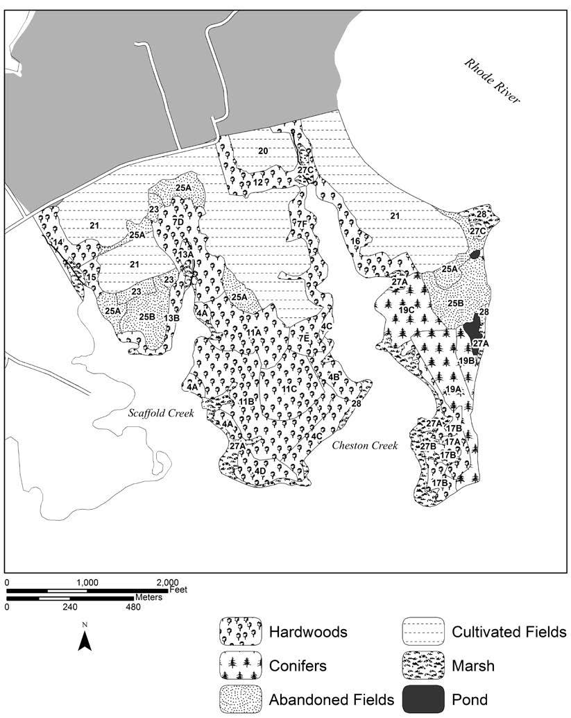
25 The two vegetation maps of the Center (Figures 4 and 5) are based on 28 vegetation types, which are listed in the legends of the maps. Details of the types are given in Table I, which includes lists of the more abundant plants and provides a basis for comparing the vegetation on Java Farm and Ivy Neck. There is less overlap between the vegetation types of the two areas than might be expected, probably in part because of the more level topography and poorer drainage at Ivy Neck, and in part because of differences in recent historical land use. No vegetation map of Corn Island has been prepared. The remainder of this report will explain the structure of the checklist and of its artificial keys. The ecological annotations which show the relationship of each species to its vegetation pattern will also be described. Introduction 11
26 Figure 4. (Opposite) VEGETATION TYPES AT JAVA FARM FOREST TYPES Hardwoods 1A. Beech, Tuliptree 1B. Beech, Tuliptree, Oaks, Hickories 1C. Beech, Tuliptree, White Oak, Sycamore, Sweetgum 2. Tuliptree, Black Oak, Blackgum 3. White, Black, and Spanish Oaks, Sweetgum *4A. Chestnut Oak, White and Black Oaks, Hickories (4B to AD only at Ivy Neck) 5. Spanish and Willow Oaks, Sweetgum, Tuliptree 6A. Walnut, Sweetgum 6B. Walnut, Sweetgum, Spanish Oak, Beech 7A. Locust, Sweetgum, Elm 7B. Locust, Black Oak, Sweetgum, Red Maple, Sassafras 7C. Locust, Sweetgum, Tuliptree, Sycamore (7D to 7F only at Ivy Neck) 8A. White Ash, Sycamore 8B. White Ash, Sycamore, Red Maple, Elm, Sweetgum 9. Tuliptree, Sweetgum, Red Maple, Sassafras 10. Dogwood, Sweetgum, Red Maple, Sassafras (11 to 17 only at Ivy Neck) Conifers 18A. Virginia Pine predominant FOREST TYPES (continued) Conifers (continued) 18B. Virginia Pine, Sweetgum, Tuliptree, Hickories *19A. Loblolly Pine, Sweetgum (pine predominant) (19B and 19C only at Ivy Neck) ABANDONED FIELD TYPES (20 and 21 are CULTIVATED FIELD TYPES, and occur only at Ivy Neck) 22A. Reed Canary Grass 22B. Kentucky Bluegrass *23. Goldenrod, Aster, Brambles, Poison Ivy, Honeysuckle, young hardwoods 24A. Sweetgum, Cherry, Red Maple, Pin Oak, Elm, Sassafras, Persimmon, Dogwood, Tuliptree, Hornbeam 24B. Virginia Pine predominant 24C. Virginia Pine, hardwoods of 24A. (25 only at Ivy Neck) MARSH TYPES Fresh Marsh 26A. Grass, Rose, Black Willow 26B. Hempweed, Touch- me- not, Black Willow Salt Marsh *27A. Sea Myrtle, Salt Reedgrass, Salt Cordgrass *27B. Saltmeadow Grass, Alkali Grass *27C. Cattail, Marsh Mallow, Salt Cordgrass, Wild Bean *Occurs also at Ivy Neck 12 ANNOTATED CHECKLIST OF THE VASCULAR FLORA AT THE CHESAPEAKE BAY CENTER FOR FIELD BIOLOGY
27 Introduction 13
28 Figure 5. (Opposite) VEGETATION TYPES AT IVY NECK FOREST TYPES Hardwoods (1 to 3 only at Java Farm) *4A. Chestnut Oak, White and Black Oaks, Hickories 4B. Chestnut Oak, White Oak, Hickories, Red Maple, Beech 4C. Chestnut Oak, Black and Scarlet Oaks, Walnut 4D. Chestnut Oak, White Oak, Virginia Pine (5 to 7C only at Java Farm) 7D. Locust, Sweetgum, Persimmon, Tuliptree, Red Maple 7E. Locust, Sweetgum, Walnut, Willow Oak 7F. Sweetgum, Walnut, Black Oak, Red Maple (8 to 10 only at Java Farm) 11A. White Oak, Sweetgum, Locust, Red Maple 11B. White and Black Oaks, Sweetgum, Tuliptree, Hickories 11C. White and Spanish Oaks, Sweetgum, Tuliptree 12. Persimmon, Locust, Cherry, Sycamore, Maples 13A. Bitternut Hickory, White Oak, Persimmon, Tuliptree 13B. Bitternut Hickory, White and Pin Oaks, River Birch 14. Tuliptree, Sweetgum, Locust, River Birch 15. White Oak, Sycamore, Walnut, Red Maple 16. Willow Oak, Black and Blackjack Oaks, Locust 17A. Cherry, Locust, Sweetgum 17B. Cherry, Locust, Black Oak, Mockernut Hickory FOREST TYPES (continued) Conifers (18 only at Java Farm) *19A. Loblolly Pine, Sweetgum (pine predominant) 19B. Loblolly Pine, Sweetgum, Locust 19C. Loblolly Pine, Virginia Pine, Sweetgum, Walnut CULTIVATED FIELD TYPES 20. Pasture 21. Cropland ABANDONED FIELD TYPES (22 only at Java Farm) *23. Goldenrod, Aster, Brambles, Poison Ivy, Honeysuckle, young hardwoods (24 only at Java Farm) 25A. Locust, Sweetgum, Cherry, Red Maple, Sassafras, Mulberry, Elm, Persimmon, Pin Oak 25B. Virginia Pine, hardwoods of 25A. MARSH TYPES (26 only at Java Farm) *27A. Sea Myrtle, Salt Reedgrass, Salt Cordgrass *27B. Saltmeadow Grass, Alkali Grass *27C. Cattail, Marsh Mallow, Switchgrass 28. Sea Rocket, False Indigo, Salt Cordgrass, Wild Bean POND TYPES Small Pond: Swamp Dock, Duckweed, Water Purslane Large Pond: Salt Cordgrass, Horned Pondweed, Marsh Mallow, Sea Myrtle *Occurs also at Java Farm 14 ANNOTATED CHECKLIST OF THE VASCULAR FLORA AT THE CHESAPEAKE BAY CENTER FOR FIELD BIOLOGY
29 Introduction 15
30 Table I. COMPARATIVE COMPOSITION OF VEGETATION TYPES AT JAVA FARM AND IVY NECK Java Farm Ivy Neck 1A. Beech, Tuliptree. FOREST TYPES HARDWOODS No counterpart. FOREST TYPES HARDWOODS Mature upland hardwoods on gentle westor south- facing slopes above tributary of Muddy Creek. Canopy mainly Fagus grandifolia; less Liriodendron tulipifera, Quercus coccinea, and other hardwoods. Understory of canopy species, plus Cornus florida, Acer rubrum, etc. Shrub and ground floras include Euonymus americanus, Epifagus virginiana, and Hypoxis hirsuta (none of these found in Type 1B). Rhus radicans and Lonicera japonica virtually absent. 1B. Beech, Tuliptree, Oaks, Hickories. Mature upland hardwoods. Fagus grandifolia and Liriodendron tulipifera throughout canopy; Liquidambar styraciflua, Quercus alba, Q. coccinea, Q. velutina, Carya tomentosa, and fewer C. falcata and C. glabra. Composition of canopy variable. Understory of canopy species, plus Cornus florida, Acer rubrum, Carpinus caroliniana, and infrequent sprouts of Castanea dentata. Shrubs include Viburnum prunifolium and infrequent Vaccinium staminium. Rhus radicans and Lonicera japonica moderately abundant. Rich herbaceous flora, most species not found in Type 1A. Herbaceous flora seems to vary with composition of the canopy. At one point, near the head of the tidal portion of Muddy Creek, the shrub and herbaceous flora resembles that of Type 4A 11B. White and Black Oaks, Sweetgum, Tuliptree, Hickories. Moderately mature lowland hardwoods; canopy resembles that of Type 1B, but contains infrequent Robinia pseudoacacia and has less Fagus grandifolia. Main difference is in understory and ground floras, which reflect poor drainage of Ivy Neck. (More Nyssa sylvatica, Viburnum prunifolium, Cercis canadensis, Lindera benzoin, Podophyllum peltatum, Arisaema atrorubens, etc.) Rhus radicans and Lonicera japonica moderately abundant. (Types 11A and 11C are described on the following pages.) 16 ANNOTATED CHECKLIST OF THE VASCULAR FLORA AT THE CHESAPEAKE BAY CENTER FOR FIELD BIOLOGY
31 Java Farm Ivy Neck 1C. Beech, Tuliptree, White Oak, Sycamore, Sweetgum. No counterpart. Mature lowland hardwoods, on level bank of Muddy Creek near head of tidal portion and on bottom of tributary valley downstream. Quercus alba prominent in canopy, also Fagus grandifolia, Liquidambar styraciflua, Liriodendron tulipifera, and Platanus occidentalis. Understory of Cornus florida on bank upstream; Lindera benzoin, Viburnum prunifolium, and V. dentatum in tributary valley. 2. Tuliptree, Black Oak, Blackgum. No counterpart. Moist lowland hardwoods, on gentle north- facing slope. Canopy of Liriodendron tulipifera and Quercus velutina throughout; Nyssa sylvatica primarily on the west side, Quercus alba on the east; few Pinus virginiana. Transition to Type 4A. Understory of Aralia spinosa, Acer rubrum, and Prunus serotina. Ground cover of Smilax rotundifolia. 3. White Oak, Black and Spanish Oaks, Sweetgum. Mature hardwoods, on southwest- facing slope. Canopy of Quercus alba, Q. velutina, a few very big Q. falcata, Liquidambar styraciflua, and Nyssa sylvatica. Understory of Cornus florida, Carya tomentosa, and Liquidambar. Ground cover of Rhus radicans and Lonicera japonica. No counterpart. Resembles Type 11C on Scaffold Peninsula (described below), but the latter has a level, poorly drained habitat. 11C. White and Spanish Oaks, Sweetgum, Tuliptree. Moderately mature; canopy of Quercus alba, Q. falcata, Liquidambar styraciflua, Liriodendron tulipifera, Nyssa sylvatica, and a few mature Pinus virginiana. Understory chiefly Ilex opaca; fewer Juniperus virginiana, Acer rubrum, Viburnum prunifolium, and Carya cordiformis. Ground cover of dense Lonicera japonica and Rhus radicans. Introduction 17
32 Table I. (Continued) Java Farm 4A. Chestnut Oak, White and Black Oaks, Hickories. Mature hardwoods of coastal zone. Canopy of Quercus alba, Q. prinus, Q. velutina, and Carya tomentosa, with fewer C. falcata and C. glabra. Mature Pinus virginiana usually few. Understory typically of Ilex opaca, Cornus florida, Acer rubrum, and a few Pinus virginiana (many young pines at Fox Point); also scattered Amelanchier arborea and Viburnum acerifolium. Castanea dentata sprouts. Ericaceous shrub layer characteristic: Kalmia latifolia, Gaylussacia baccata, G. frondosa, Vaccinium spp. Ground flora includes mosses, Hieracium venosum, and Deschampsia flexuosa. Smilax rotundifolia usually sparse; Rhus radicans and Lonicera japonica conspicuously absent. Ivy Neck 4A. Very similar in composition to that at Java Farm, and occupies the same habitat: a narrow zone where the bank drops steeply to the Bay (probably a zone of improved drainage caused by a drop in the soil water table); the finer texture of soil at Ivy Neck seems to make little difference with this type. 4B. Chestnut Oak, White Oak, Hickories, Red Maple, Beech. Differs from Type 4A in having Fagus grandifolia and Acer rubrum in the canopy, and a more heterogeneous understory which seems transitional to inland Types 11B and 11C. Understory includes Cercis canadensis, Sassafras albidum, Viburnum prunifolium, and Carya cordiformis. Rubus spp. and Campsis radicans also. 4C. Chestnut Oak, Black and Scarlet Oaks, Walnut. Canopy and understory are more varied than in either 4A or 4B; has less Quercus prinus and almost no ericaceous shrubs. New canopy species include Q. coccinea, Juglans nigra, Liquidambar styraciflua, Liriodendron tulipifera, Asimina triloba, etc. 4D. Chestnut Oak, White Oak, Virginia Pine. Differs from 4A in having infrequent Pinus virginiana in canopy Hardwoods formerly lumbered. Pine abundant in understory, with Acer rubrum and Liquidambar styraciflua. Ilex opaca and ericaceous shrubs infrequent. 18 ANNOTATED CHECKLIST OF THE VASCULAR FLORA AT THE CHESAPEAKE BAY CENTER FOR FIELD BIOLOGY
33 Java Farm Ivy Neck 5. Spanish and Willow Oaks, Sweetgum, Tuliptree. No counterpart. Mature lowland hardwoods adjacent Hog Island salt marsh. Canopy of Quercus falcata, Q. phellos, Liquidambar styraciflua, and Liriodendron tulipifera. Understory of Cornus florida, Liquidambar, Aralia spinosa, and Viburnum dentatum; infrequent Quercus stellata and Pinus virginiana. Seems to be invading drier areas of salt marsh. 6A. Walnut, Sweetgum. Mature stand, probably persistent from cultivation, on steep east- and west- facing slopes of ridge. Canopy of Juglans nigra only on east side; with Pyrus communis, Liquidambar styraciflua, and Sassafras albidum on west side. Understory of Lindera benzoin on east slope, Rubus on west. Dense Lonicera japonica on both sides. 6B. Walnut, Sweetgum, Spanish Oak, Beech. No counterpart. Walnut grows infrequently along both sides of Cheston Creek estuary, in Types 4C, 7E, 7F, and 19C, and on upper Scaffold Creek estuary in Type 15, but not abundantly enough to characterize a stand. No counterpart. Moderately mature, at top of southfacing slope. Canopy of Liquidambar styraciflua, Juglans nigra, Quercus falcata, Fagus grandifolia, and Platanus occidentalis. Understory of Lindera benzoin and Cornus florida. Lonicera japonica on ground. Introduction 19
34 Table I. (Continued) Java Farm 7A. Locust, Sweetgum, Elm. Immature, on south- and southeastfacing slopes overlooking Fox Creek estuary. Canopy of Robinia pseudoacacia, Liquidambar styraciflua, and Ulmus americana; fewer Sassafras albidum and Quercus velutina, the latter mostly on the lower slopes. Understory of canopy species. Dense ground cover of Lonicera japonica. Also contains scattered Acer rubrum and Cornus florida. 7B. Locust, Black Oak, Sweetgum, Red Maple, Sassafras. Immature, on south- facing slope near head of Fox Creek estuary. Canopy of Robinia pseudoacacia and Liquidambar styraciflua, with fewer Quercus velutina, Acer rubrum, Cornus florida, and Sassafras albidum. Understory of canopy species, plus Ulmus americana. Ground cover of Lonicera japonica and Rhus radicans. 7C. Locust, Sweetgum, Tuliptree, Sycamore. Moderately mature, along the shore of Muddy Creek estuary. Canopy chiefly Robinia pseudoacacia, especially near Hog Island salt marsh; also includes Liquidambar styraciflua, Cornus florida, Liriodendron tulipifera, and Platanus occidentalis near the eastern end. Understory of canopy species. Ground layer of Rhus radicans, Smilax rotundifolia, and Lonicera japonica. Ivy Neck Types 7D, 7E, and 7F at Ivy Neck resemble Types 7A and 7B at Java Farm in species composition. Chief difference is in the habitat: from moderately steep south- facing slope and fine sandy loam soil at Java Farm to poorly drained level lowland and silt loam soil at Ivy Neck. 7D. Locust, Sweetgum, Persimmon, Tuliptree, Red Maple. Immature, covers watershed of east fork of Scaffold Creek. Canopy seems to contain no Quercus velutina but does include Diospyros virginiana, Nyssa sylvatica, and Platanus occidentalis. Otherwise the same as at Java Farm (Robinia, Liquidambar, Ulmus ) Understory highly variable, includes Sassafras albidum, Cornus florida, Lindera benzoin, Viburnum prunifolium, Acer rubrum, and Carya cordiformis. Shrub and ground layers of Rubus spp., Rhus radicans, and Lonicera japonica. Type 11A, described on the next page, seems to be a transition between 7D above and 11B (described on p. 16). 7E. Locust, Sweetgum, Walnut, Willow Oak. Immature, covers west bank of Cheston Creek estuary north of Type 4B. Resembles Type 7F (p. 21) and differs from other variations of Type 7 in having Juglans nigra in the canopy. Canopy of Robinia pseudoacacia, Liquidambar styraciflua, Juglans nigra, and Quercus phellos. Understory of Robinia pseudoacacia, Cornus florida, and Sassafras albidum. Ground layer Lonicera japonica and Smilax rotundifolia. 20 ANNOTATED CHECKLIST OF THE VASCULAR FLORA AT THE CHESAPEAKE BAY CENTER FOR FIELD BIOLOGY
35 Java Farm Ivy Neck No counterpart. 7F. Sweetgum, Walnut, Black Oak, Maple. Immature, adjoins Type 7E. Canopy has little or no Robinia, added Quercus velutina, Salix nigra, Acer rubrum, and Platanus occidentalis. Understory of Viburnum prunifolium, Prunus serotina, and Cercis canadensis. Ground layer as in Type 7E. No counterpart. 11A. White Oak, Sweetgum, Locust, Red Maple. Immature, apparently a transition between Types 7D and 11B. Canopy of Quercus alba, Liquidambar styraciflua, Nyssa sylvatica, Acer rubrum, and Carya spp.; Robinia pseudoacacia becomes infrequent southward; Ulmus americana infrequent. Understory varied, includes Rhus typhina, Ailanthus altissima, Cornus florida, Viburnum prunifolium, Morus alba, Cercis canadensis, etc. Ground cover of Lonicera japonica and Rhus radicans. 8A. White Ash, Sycamore. Moderately mature, follows bottom of Muddy Creek valley above tidal limit. Canopy mostly Fraxinus americana, fewer Platanus occidentalis, few species of Type 8B below. Understory of Lindera benzoin, with few Acer rubrum, Fraxinus, Liquidambar, Ulmus americana, and Carpinus caroliniana. Ground layer of Rubus spp., Vitis spp., and Rhus radicans. Herbaceous flora mostly Impatiens capensis, Podophyllum peltatum, and assorted grasses. 12. Persimmon, Locust, Cherry, Sycamore, Maples. Moderately mature, follows drainage of Cheston Creek above tidal limit. Persimmon and cherry may be cultivated. Understory inhibited by browsing cattle. Canopy of Diospyros virginiana, Robinia pseudoacacia, Prunus serotina, Platanus occidentalis, Acer rubrum, A. saccharinum, A. negundo, Liquidambar styraciflua, Nyssa sylvatica. Understory of Viburnum prunifolium, Salix nigra, Cercis canadensis, Celtis occidentalis. Ground layer chiefly grass, or forbs in wet areas. Introduction 21
36 Table I. (Continued) Java Farm Ivy Neck 8B. White Ash, Sycamore, Red Maple, Elm, Sweetgum. Similar to Type 8A but farther upstream. More heterogeneous canopy includes Acer rubrum, Ulmus americana, Liquidambar styraciflua, and Quercus palustris. Understory as in Type 8A, with more Ulmus americana and Carpinus caroliniana. Ground layer same. 9. Tuliptree, Sweetgum, Red Maple, Sassafras. No counterpart. Immature, covers north- and west- facing slopes of hill overlooking wet meadow. Canopy of Liriodendron tulipifera, Liquidambar styraciflua, Acer rubrum, and Sassafras albidum. Understory similar, plus Ilex opaca, Prunus serotina, Nyssa sylvatica, Cornus florida, Viburnum prunifolium. Ground layer of Lonicera japonica. 10. Dogwood, Sweetgum, Red Maple, Sassafras. No counterpart. Immature, covers east- facing slope at head of Fox Creek estuary; merges with Virginia pine stand (Type 18A) on upper slope. Canopy of Cornus florida, Acer rubrum, Sassafras albidum, Liquidambar styraciflua, Pinus virginiana, few Fagus grandifolia and Morus rubra. Understory similar. Ground layer of Smilax rotundifolia, stopping sharply at edge of pine canopy. 22 ANNOTATED CHECKLIST OF THE VASCULAR FLORA AT THE CHESAPEAKE BAY CENTER FOR FIELD BIOLOGY
37 Java Farm Ivy Neck No counterpart. 13A. Bitternut Hickory, White Oak, Persimmon, Tuliptree. Moderately mature but canopy thin. Lower valley of Scaffold Creek (east fork) above tidal limit. Canopy of Carya cordiformis, fewer Quercus alba, Platanus occidentalis, Diospyros virginiana, and Liriodendron tulipifera. Understory thin, of Morus rubra, Juglans nigra, Ulmus rubra, Quercus palustris, etc. Shrub and ground layers very dense, of Rubus spp., Smilax rotundifolia, and Lonicera japonica. No counterpart. (Habitat of Type 7C resembles that of 13B except that 7C has fine sandy loam soil; 13B has silt loam). No counterpart, 13B. Bitternut Hickory, White and Pin Oaks, River Birch. Moderately mature, borders field between forks of Scaffold Creek. Canopy of Carya cordiformis, Quercus alba, Q. palustris. Understory of Cornus florida and Viburnum prunifolium, few Quercus alba, Q. stellata, Carya glabra, and Fagus grandifolia. Ground layer of mixed grasses, few woody vines. 14. Tuliptree, Sweetgum, Locust, River Birch. Immature, covers drainage of west fork of Scaffold Creek. Canopy of Liriodendron tulipifera, less Liquidambar styraciflua, Robinia pseudoacacia, Betula nigra, and Juniperus virginiana. Understory of Viburnum spp., Carya cordiformis, Quercus velutina, and Q. palustris. Ground layer of Rhus radicans. Introduction 23
38 Table I. (Continued) No counterpart. Java Farm Ivy Neck 15. White Oak, Sycamore, Walnut, Red Maple. Moderately mature, at head of west fork of Scaffold Creek estuary. Canopy of Quercus alba, Platanus occidentalis, fewer Acer rubrum, Juglans nigra, and Carya tomentosa. Understory of Liquidambar styraciflua, Morus rubra, Carya cordiformis. Ground layer of Lonicera japonica, less Smilax rotundifolia and Rhus radicans. No counterpart. 16. Willow Oak, Black and Blackjack Oaks, Locust. Immature, along east shore of upper Cheston Creek estuary, borders cultivated field. Canopy has Quercus phellos throughout; Diospyros virginiana near upstream end; Liquidambar styraciflua near middle; Quercus velutina, Q. marilandica, Q. palustris, and Q. prinus near downstream end. Understory of Viburnum prunifolium, Prunus serotina, Maclura pomifera, Sassafras albidum, etc. Ground layer of Rubus spp., Lonicera japonica, Rhus radicans, other vines. No counterpart. 17A. Cherry, Locust, Sweetgum. Immature; coves behind salt marsh on lower Cheston Peninsula. Canopy thin, variable, includes Prunus serotina, Robinia pseudoacacia, Liquidambar styraciflua, Cornus florida, Betula nigra, Liriodendron tulipifera, Carya tomentosa, Quercus velutina. Understory merges with canopy; one clump Rhus typhina. Ground layer of dense Lonicera japonica, Rhus radicans, other vines. 24 ANNOTATED CHECKLIST OF THE VASCULAR FLORA AT THE CHESAPEAKE BAY CENTER FOR FIELD BIOLOGY
39 Java Farm Ivy Neck No counterpart. (Habitat like that of Type 4). 17B. Cherry, Locust, Black Oak, Mockernut Hickory. Immature; on Cheston Point and low headlands adjoining salt marsh. Canopy of Prunus serotina, Robinia pseudoacacia, Quercus velutina, Carya tomentosa, Q. alba, Betula nigra. Understory on Cheston Point of Liquidambar styraciflua and Ulmus americana; on headlands of Ilex opaca and Viburnum prunifolium. Ground layer of Smilax rotundifolia on one headland; Rubus spp., Rhus radicans, and Lonicera japonica elsewhere. CONIFERS CONIFERS 18A. Virginia Pine predominant. No counterpart. Moderately mature; scattered stands usually on upper slopes or summits, exception at head of tidal part of Muddy Creek. Canopy of Pinus virginiana, may have few Liquidambar styraciflua, stand at bend of Fox Point Rd. has few Quercus velutina and Q. marilandica. Understory of mixed hardwoods, chiefly Liquidambar, Acer rubrum, etc. Ground layer usually Lonicera japonica. Introduction 25
40 Table I. (Continued) Java Farm 18B. Virginia Pine, Sweetgum, Tuliptree, Hickories. A mixture of Type 18A above and hardwood Type 1B (p. 16). West- facing slope of ridge with water tank. Canopy on lower slope of Pinus virginiana and Liquidambar, latter gives way upslope to Liriodendron tulipifera, Carya tomentosa, and few Quercus velutina. Mature pine only on slope, summit has young pine and hardwood stands (Types 24A, B, C). Understory all over slope of Liriodendron, Acer rubrum, Sassafras albidum, and few Pinus virginiana. Shrubs only on lower slope: Vaccinium spp., Myrica cerifera. Ground layer below of Mitchella repens and Lycopodium complanatum, of Rhus radicans on upper slope. 19A. Loblolly Pine, Sweetgum (pine predominant). Mature; on south- facing slope of ridge with water tank, described for Type 18B. Canopy of Pinus taeda and Liquidambar styraciflua. Understory of Liquidambar, Liriodendron tulipifera, and Acer rubrum. Ground layer of Rhus radicans. Also one mature Pinus taeda at headquarters area and one at west end of Fox Point Road; few young ones in old fields (Type 23). No counterpart. Ivy Neck No true counterpart; few mature Pinus virginiana remain of former stand on Scaffold Peninsula (now hardwood Type 11C). This area resembles Type 18B to the extent that Type 11C resembles Type 1B at Java Farm, see discussion on pp A. Loblolly Pine, Sweetgum (pine predominant). Mature; planted in 1933 on Cheston Peninsula. Very dense; many trees down, rest with thin crowns; reproduction at stand borders. Canopy of Pinus taeda, few Liquidambar styraciflua and Liriodendron tulipifera. Understory of dense Liquidambar, Liriodendron, Cornus florida; fewer Prunus serotina, Ulmus americana, and Quercus velutina. Ground layer of dense Rhus radicans and Lonicera japonica. 19B. Loblolly Pine, Sweetgum, Locust. Immature; triangular area on Cheston Peninsula between 19A and coast. Thin canopy of Pinus taeda, Liquidambar styraciflua and Robinia pseudoacacia. Dense understory same as for Type 19A, with few young Pinus taeda. Dense ground layer of Rhus radicans, Lonicera japonica, Campsis radicans, Vitis sp. 26 ANNOTATED CHECKLIST OF THE VASCULAR FLORA AT THE CHESAPEAKE BAY CENTER FOR FIELD BIOLOGY
41 Java Farm Ivy Neck No counterpart. 19C. Loblolly Pine, Virginia Pine, Sweetgum, Walnut. Immature; on Cheston Peninsula between Type 19A and cultivated field. Canopy of Liquidambar styraciflua, fewer Pinus taeda, P. virginiana, and Juglans nigra. Understory of Acer rubrum, Carya cordiformis, Ilex opaca, Nyssa sylvatica, Quercus alba, Q. palustris, and Q. phellos. Shrubs: Myrica cerifera, Viburnum prunifolium. Ground layer of Rhus radicans and Lonicera japonica. CULTIVATED FIELD TYPES No counterpart. 20. Pasture. Single pasture, grazed by dairy herd. Gentle south- facing slope, bordered on 3 sides by Cheston Creek drainage. Flora of Andropogon virginicus, Digitaria ischaemum, Trifolium repens, Taraxacum officinale, other forbs. No counterpart. 21. Cropland. Cultivated to corn, barley, wheat, and sorghum. Wild flora mostly Ipomoea purpurea, I. hederacea; also (vernal): Stellaria media, Draba verna, Lepidium spp., Barbarea spp., Cerastium spp., etc. and (autumnal) Aster spp.; restricted or infrequent species: Datura stramonium, Echinochloa pungens; Setaria lutescens often abundant near borders. Introduction 27
42 Table I. (Continued) Java Farm Ivy Neck One field on Scaffold Peninsula, described in text as abandoned wheatfield (since recultivated) was fallow 3 yrs. ( ); 60 species were found there in 1966, especially Oenothera biennis, O. fruticosa, Gnaphalium obtusifolium, Cerastium viscosum, Dianthus armeria, Hypericum perforatum, Ambrosia artemisiifolia. Locally dense Trifolium pratense and T. hybridum. Woody species found under forbs: Campsis radicans dense; Quercus velutina, Prunus serotine, and Vitis sp. few. FORMERLY CULTIVATED FIELD TYPES 22A. Reed Canary Grass. Former pasture in valley north of headquarters area, marshy at the west end, drains into Muddy Creek. Very dense Phalaris arundinacea throughout; Juncus effusus, Scirpus rubricosus, Polygonum pensylvanicum, and P. sagittatum at marshy end; few clumps of young Acer rubrum, Liquidambar styraciflua, and Rosa spp. Invasion from outside slow. 22B. Kentucky Bluegrass. Small areas of dense Poa pratensis turf in former cultivated fields, being overrun by Rhus radicans. Associated forbs: Gnaphalium obtusifolium, Erigeron canadensis, Asclepias syriaca, Solanum carolinense, Cirsium discolor. FORMERLY CULTIVATED FIELD TYPES No counterpart. (When the field described above was abandoned, its north end adjacent Cheston Creek drainage had marshy species like that of western part of Type 22A.) No counterpart. 28 ANNOTATED CHECKLIST OF THE VASCULAR FLORA AT THE CHESAPEAKE BAY CENTER FOR FIELD BIOLOGY
43 Java Farm 23. Goldenrod, Aster, Brambles, Poison Ivy, Honeysuckle, scattered young hardwoods. Very heterogeneous vegetation throughout most former cultivated fields. Forbs often more abundant than woody vines but often less so. Principal forbs: Solidago altissima, S. graminifolia, Aster pilosus, A. dumosus, Eupatorium serotinum, Rubus occidentalis, Lespedeza cuneata, Rosa micrantha, R. multiflora, Allium vineale. Early spring forbs: Barbarea spp., Draba verna, Lepidium spp., etc. Principal vines: Rhus radicans, Lonicera japonica, Campsis radicans, Vitis vulpina. Many less frequent species. Trees scattered or locally dense; see Type 24A. Ivy Neck 23. Goldenrod, Aster, Brambles, Poison Ivy, Honeysuckle, scattered young hardwoods. Similar to that at Java Farm but with fewer vines, more grass and forbs. Merges with Types 25A, 25B. Grasses include Setaria lutescens, Andropogon virginicus. 24A. Sweetgum, Cherry, Red Maple, Pin Oak, Elm, Sassafras, Persimmon, Dogwood, Tuliptree, Hornbeam. Very dense young stands, often predominantly Liquidambar styraciflua but often heterogeneous. Covers parts of old fields and usually merges with Type 23. Principal species: Liquidambar, Prunus serotina, Acer rubrum, Quercus falcata, Sassafras albidum, Cornus florida. Less frequent: Liriodendron tulipifera (central upland), Diospyros virginiana (lowland), Ulmus americana, U. rubra (near pier), Carpinus caroliniana (forest border), Celtis occidentalis (all over). Understory usually none. Ground layer of dense Lonicera japonica and Rhus radicans in all stands. Special cases: South- facing slope at north border (adjacent Type 22A) is an old orchard; canopy of Liquidambar, Liriodendron, and Pyrus malus. Understory of Rubus spp. 25A. Locust, Sweetgum, Cherry, Red Maple, Sassafras, Mulberry, Elm, Persimmon, Pin Oak. Corresponds to Type 24A but has Robinia pseudoacacia usually abundant; Liriodendron, Carpinus, Ulmus rubra, and Celtis infrequent to absent. Special cases: Stand at head of Scaffold Creek drainage includes Nyssa sylvatica, Platanus occidentalis, Carya cordiformis, and shrubs Viburnum prunifolium and Sambucus canadensis. Stand on Cheston Peninsula below Type 21 includes dense understory of Myrica cerifera. Hedgerows between cultivated fields usually contain Celtis occidentalis, Liquidambar styraciflua, Maclura pomifera, Acer rubrum, or Viburnum prunifolium; also Campsis radicans. Introduction 29
44 Table I. (Continued) Java Farm Ivy Neck West- facing slope down to Muddy Creek near head of tidal portion has very dense Carpinus canopy; so does stand at end of Springhouse Road. 24B. Virginia Pine predominant. No counterpart. Dense young stands of Pinus virginiana. Two occur on summit and west- facing slope of ridge west of headquarters area, one in old field on northeast- facing slope near Fox Point Rd. Few Liquidambar in stands, no understory; ground cover of Rhus radicans and Lonicera japonica. Pine also infrequent in Type C. Virginia Pine, hardwoods of 24A. Simultaneous growth of young Pinus virginiana and Liquidambar styraciflua in old fields. Stand overlooking head of Fox Creek estuary also has Robinia pseudoacacia, Quercus palustris, Cornus florida, and Sassafras albidum. Stand at west end of field overlooking Muddy Creek at southwest corner of Farm has Liriodendron tulipifera and Aralia spinosa. 25B. Virginia Pine, hardwoods of 25A. Infrequent occurrence of Pinus virginiana throughout young hardwood canopies between forks of Scaffold Creek estuary and on Cheston Peninsula between pine stand and cultivated fields. Ground cover of Rhus radicans and Lonicera japonica. Ground cover of Rhus radicans and Lonicera japonica. MARSH TYPES MARSH TYPES Freshwater Marsh 26A. Grass, Rose, Black Willow. No freshwater marshes occur at Ivy Neck. Freshwater portion of marsh at mouth of Fox Creek drainage, separated from salt marsh by hedge of Rosa palustris and Smilax rotundifolia. Assorted grasses, scattered Salix nigra, clumps of Rosa palustris, Impatiens capensis, and Scirpus spp. 30 ANNOTATED CHECKLIST OF THE VASCULAR FLORA AT THE CHESAPEAKE BAY CENTER FOR FIELD BIOLOGY
45 Java Farm Ivy Neck 26B. Hempweed, Touch- me- not, Black Willow. Two sites: marshy streambed at western border of Farm and at base of Fox Point peninsula adjoining Fox Creek estuary. Both sites have dense Impatiens capensis and Mikania scandens, and scattered Salix nigra and Smilax rotundifolia. Scutellaria lateriflora and Rosa spp. grow at the first site, Sambucus canadensis at the second. Salt Marsh 27A. Sea Myrtle, Salt Reedgrass, Salt Cordgrass. Covers the wettest and apparently most saline marsh areas and follows tide channels into apparently less saline areas. Chiefly Baccharis halimifolia, Spartina cynosuroides, S. alterniflora; less abundant species: Iva frutescens, Aster subulatus, A. tenuifolius, Limonium carolinianum, Phragmites communis. Salt Marsh and Beach 27A. Sea Myrtle, Salt Reedgrass, Salt Cordgrass. Same as at Java Farm; Spartina cynosuroides infrequent, only at edge of water. 27B. Saltmeadow Grass, Alkali Grass. Covers more sheltered, inland areas of large marshes; often absent from smaller ones. Chiefly Spartina patens, Distichlis spicata; less abundant species: Solidago sempervirens, Eleocharis halophila. 27B. Saltmeadow Grass, Alkali Grass. Same as at Java Farm but areas often too small to map. 27C. Cattail, Marsh Mallow, Switchgrass. Occurs at landward margins of marshes or throughout less saline ones. Chiefly Typha latifolia, T. angustifolia, Hibiscus palustris, Kosteletzkya virginica, Panicum virgatum; less abundant species: Acnida cannabina, Pluchea camphorata. 27C. Cattail, Marsh Mallow, Switchgrass. Same as at Java Farm, but areas often too small to map. Introduction 31
46 Table I. (Continued) Java Farm Tidal portion of Muddy Creek has gradient of decreasing salinity. Species there not cited above: Scirpus americanus, S. robustus (Hog I. Marsh); Atriplex patula, Dryopteris thelypteris (with Typha), Polygonum hydropiperoides, Asclepias incarnata, and Mikania scandens (at upstream end). No counterpart. Ivy Neck Salt marsh at head of Cheston Creek estuary has several species cited for tidal Muddy Creek. Trees occasionally found in salt marshes include Diospyros virginiana and Juniperus virginiana at several locations, Robinia pseudoacacia at Sand Point, Quercus falcata and Q. phellos at Hog Island marsh, and Salix nigra at head of Fox Creek. The last three species occur near the dry land border. 28. Sea Rocket, False Indigo, Salt Cordgrass, Wild Bean Sandy beach along Cheston Peninsula, and sandbars of salt marshes. Species include Cakile edentula, Amorpha fruticosa, Spartina alterniflora, Strophostyles helvola, Cenchrus tribuloides, Ammophila arenaria, Asparagus officinale. Baccharis halimifolia dense on Sand Point. POND TYPES No counterpart (types 26A and 26B may be temporarily innundated, but true ponds are lacking.) No counterpart. POND TYPES 29A. Small pond on Cheston Peninsula, separated from Rhode River by an apparently stable sandbar. Vegetation indicates low salinity at present; species include Rumex verticillatus, Echinochloa walteri, Sparganium eurycarpum, Lemna minor, Spirodela polyrhiza, Ludwigia palustris. 29B. Larger pond on Cheston Peninsula, separated from Rhode River by an eroding sandbar. Vegetation indicates a salinity equivalent to that of marshes; species include Spartina alterniflora, Zannichellia palustris, Hibiscus palustris, Baccharis halimifolia, Pluchea camphorata. 32 ANNOTATED CHECKLIST OF THE VASCULAR FLORA AT THE CHESAPEAKE BAY CENTER FOR FIELD BIOLOGY
47 Structure of the Checklist and Keys The checklist includes 553 species of vascular cryptogams and phanerogams, distributed among 98 families. They were collected at Java Farm in the autumn of 1965 and at both Java Farm and Ivy Neck during the growing seasons of 1966 and Collection will be started at Corn Island in 1968 and continued elsewhere in coordination with studies of vegetation development. An appendix (p. 225) is provided for the addition of new species. It now contains eight species collected during the preparation of this checklist. When the Center becomes further developed the checklist will be revised for final publication. The families represented in the checklist are indexed on page 40 and arranged according to the Engler and Prantl system. When a family is represented by more than one species artificial keys are provided. Although many of the keys are set up in a form similar to that used in Gray s Manual of Botany, 8th edition ( Fernald, 1950), the keys developed for this checklist are less extensive than Fernald s, since they are restricted to the flora of the Center and its near vicinity. In addition, the terminology has been simplified and in some of the more complex keys the sequence has been revised. The keys in three families have been adapted from those of local taxonomic studies compiled for the Washington- Baltimore area, which includes Anne Arundel County (Hermann, 1946). These three families are the Gramineae (Gilman, 1957), the Cyperaceae (Hermann, 1941), (O Neill, 1941), and the Umbelliferae (Dayton, 1942). The adapted keys were modified to exclude species having a strictly Piedmont distribution and those restricted to habitats which do not occur at the Chesapeake Bay Center. Entirely new keys were prepared for some of the more complex taxa which have limited representation at the Center. There are two reasons for any similarities present between keys in the literature cited above and keys in the checklist. First, the dependability of the characters in the keys in the literature. Second, the need of a framework to facilitate the anticipated periodic revision of the keys as additional species are collected. Such 33
48 revisions will be accomplished more readily if the organization of the checklist keys is designed to allow for them. Therefore, when a couplet in one of the keys in the literature separates a genus or species which has in fact been collected at the Center from one not yet discovered there but expected to occur in the vicinity, both halves of the couplet are included in the checklist key but the word expected follows the unused half and the taxa to which it refers are named in parentheses. This practice appears justifiable in view of the continued investigations to be conducted at the Center and the rich and fluctuating flora of the surrounding county, described by Stieber (1967). Stieber notes a great intermingling of northern, southern, and introduced species, the whole assembly subjected to widespread human disturbance. From field collections west of the Chesapeake Bay Center and an examination of the District of Columbia and Vicinity collection in the U. S. National Herbarium, Stieber has compiled a checklist of 647 vascular species for the county. His list cites 316 species not yet discovered at the Chesapeake Bay Center; the writer has collected at the Center 209 species which are not included on Stieber s list for the county. This complementary collection reinforces Stieber s observation on the need for further systematic floristic study of the region, and supports the writer s provision for the inclusion of additional taxa in the keys of the present list. To prevent the checklist keys from becoming top- heavy with expected taxa, the writer has used the following criteria in selecting them: 1. They must be named as established in F. J. Hermann s A Checklist of Plants in the Washington- Baltimore Area, 2nd edition (Hermann, 1946). 2. They must be described in the available literature as having a distribution which includes the Maryland Coastal Plain, and must not be restricted to swamps or other habitats which do not occur at the Center. 3. They must not be too numerous to keep the keys relatively simple and short. This system of including expected taxa in the keys has already facilitated the identification of several species listed in Appendix I. Further research at the Center may reveal other taxa not yet listed as expected. The identification of new taxa may be confirmed by the use of Gray s Manual. Nomenclature The nomenclature of the checklist follows that of Gray s Manual of Botany, 8th edition, except in the family Gramineae; there, Gilman (1957) follows the nomenclature of A. S. Hitchcock s Manual of the Grasses of the United States. Whenever the nomenclature used conflicts with that of The New Britton and Brown Illustrated Flora (Gleason, 1952), the names from the latter are given in parentheses. Common names of species given by Gray s Manual are placed opposite the scientific names. 34 ANNOTATED CHECKLIST OF THE VASCULAR FLORA AT THE CHESAPEAKE BAY CENTER FOR FIELD BIOLOGY
49 Additional common names used by residents of the vicinity of the Chesapeake Bay Center are distinguished by the letter (L), for local, or are listed separately in Appendix III. Annotations The ecological annotation which accompanies each species has five categories: the general location (Java Farm or Ivy Neck), the estimated abundance of the species, its exact collection site or specific habitat, the dominant or canopy species of the collection site, and some of the associate species observed in the same location and stratum. The estimated abundance of an entry indicates the ease or rediscovering that species in the field; the four categories are: Abundant (plentiful throughout the habitat) Moderately abundant (evenly distributed but not plentiful) Infrequent (thinly scattered) One station (a single plant or very small, compact group) The last category is preferred to Rare or Local because the Center has not yet been studied in sufficient detail to permit a safe assumption concerning the restriction of distribution of species. Additional annotation data are being sought and are listed in Appendix II, When the checklist is revised a more precise evaluation will be made. The specific location of a species is described in relation to existing landmarks and to the numbered grid now being constructed for the entire Center (see Figures 6 and 7). The units of the grid are in hectares (a hectare equals acres or 10,000 square meters). The hectare was chosen to facilitate the future establishment of sample plots, since it can easily be broken down into smaller metric units. Once the location of a species is established the reader may check the soil and vegetation maps (Figures 2 to 5) for additional details. The remaining annotation data summarize the vegetation of the collecting sites. The dominant species are listed when these are apparent. Also listed are associate species collected or observed at the same location and in the same stratum. Further investigation of the coincidence of these associate species should lead to more reliable correlations among them and with their habitats. Additional details of the vegetation may be obtained from Figures 4 and 5 and from Table I. The specimen collection numbers of each species follow its annotation. All specimens collected by the writer are preserved in the U. S. National Herbarium, Washington, D.C. Duplicate specimens will be filed at the Chesapeake Bay Center. A few additional specimens collected by Dr. H. David Hammond are kept in the Howard University Herbarium, Washington, D.C. Structure of the Checklist and Keys 35
50 Hectare Coordinates of the Chesapeake Bay Center for Field Biology These maps (Figures 6, 7) represent a grid system which provides a large number of fixed points for designating sampling stations and recording collections. Each square of the grid is 100 meters on a side and has an area of 10,000 square meters or 1 hectare (1 hectare = acres). The squares may be easily broken down into smaller metric units. Each of the larger squares (with heavier borders) contains 100 hectare squares. The vertical grid lines run north and south at right angles to the baseline, not according to magnetic north. The heavy horizontal line crossing Java Farm is the baseline; trees and brush along this line have been cleared to make a relatively open footpath. Disturbance to the vegetation along the other grid lines has been kept to a minimum. Although the grid lines on these maps extend beyond the boundaries of the Chesapeake Bay Center, the actual surveying has been confined to the Smithsonian property. In the field the corners of each square are pinpointed either by concrete monuments or by pipes driven into the ground. The monuments are placed two hectares apart, and have brass plates bearing the numbers of the adjoining squares. Where pipes are used, stakes bearing the grid numbers accompany them. No markers have been planted in the estuaries. 36 ANNOTATED CHECKLIST OF THE VASCULAR FLORA AT THE CHESAPEAKE BAY CENTER FOR FIELD BIOLOGY

51 Figure 6. Structure of the Checklist and Keys 37

52 Figure ANNOTATED CHECKLIST OF THE VASCULAR FLORA AT THE CHESAPEAKE BAY CENTER FOR FIELD BIOLOGY
Appendix VII-A-3. Upland Sites Summary of Ten Meter Square Survey at Site B/H-7 July 22, 2015
 Appendix VII-A-3. Upland Sites Summary of Ten Meter Square Survey at Site B/H-7 The area was Terrestrial, with a 30 to 65% slope (steep) and a Topographical Position of middle slope. The Dominant Understory
Tree Planting Memorial Park Demonstration Project
 Tree Planting Memorial Park Demonstration Project Nic Griffin Vegetation Management Coordinator Tree Planting Program Objectives Establish a closed canopy of trees to reduce or eliminate cyclical maintenance
Natural Resources Group Forest Restoration Team Spring 2004 Summary
 City of New York Parks & Recreation Natural Resources Group The Arsenal Arsenal North Central Park 1234 Fifth Avenue New York, New York 10021 New York, New York 10029 Adrian Benepe Commissioner Bill Tai,
B/B5 ( Site)
") B/B5 (1990-2016 Site) Latitude 38 27.165 N Longitude -76 28.343 W North Loop Trail B5 Site Description (Date Located 3/24/2016): B5 is the most distant of any sites from trail access. It is located 4700
B/B5 (1990-2016 Site) Latitude 38 27.165 N Longitude -76 28.343 W North Loop Trail B5 Site Description (Date Located 3/24/2016): B5 is the most distant of any sites from trail access. It is located 4700
! " Alternatives to Ash: Native Trees for Southern Wisconsin" Compiled by the UW Madison Arboretum! January, 2014!
 " Alternatives to Ash: Native Trees for Southern Wisconsin" Compiled by the UW Madison Arboretum January, 2014 The UW Madison Arboretum recommends planting native tree species to replace ash trees (Fraxinus
NATIVE TREES (Native Shrubs following) FALL 2016
 FALL 2016") NATIVE TREES (Native Shrubs following) FALL 2016 Botanical Name Common Name Size Available Price Qty. 1-24 Price Qty. 25+ Acer negundo Box Elder 2 gal 3-5' 150 $8.75 $7.75 Acer negundo Box Elder 2 gal
NATIVE TREES (Native Shrubs following) FALL 2016 Botanical Name Common Name Size Available Price Qty. 1-24 Price Qty. 25+ Acer negundo Box Elder 2 gal 3-5' 150 $8.75 $7.75 Acer negundo Box Elder 2 gal
Botanical Name Common Name Size Available
 NATIVE TREES Botanical Name Common Name Size Available Acer negundo Box Elder 2 gal, 4-5 66 Acer negundo Box Elder 7 gal, 5-8, 1 + 22 Acer rubrum Red Maple 1 gal, 2-4 70, 90 (4') Acer rubrum Red Maple
Ecological regions of Kentucky
 Ecological regions of Kentucky Latin name Common name Mississippi Embayment Shawnee Hills Mississippian Plateaus Bluegrass Appalachian Plateaus Acer rubrum Red maple X X X X X Acer saccharum Sugar maple
NATIVE TREES, SHRUBS & PERENNIALS
 NATIVE TREES, SHRUBS & PERENNIALS SPRING 2014 AVAILABILITY NATIVE TREES Botanical Name Common Name Size Available Price Qty. 1-24 Price Qty. 25+ Acer negundo Box Elder 2 gal, 4-5 50 $8.95 $7.50 Acer negundo
Recent Advances in Critical Loads Research for the U.S.: Synthesizing tree CLs
 Recent Advances in Critical Loads Research for the U.S.: Synthesizing tree CLs Christopher M. Clark, EPA ORD/NCEA Kevin Horn, Virginia Polytechnic University R. Quinn Thomas, Virginia Polytechnic University
Planting Design Considerations for a Changing Climate As it relates to Natural Channel Design
 Planting Design Considerations for a Changing Climate As it relates to Natural Channel Design Presented by: Amy Bennewies Landscape Architect and Certified Arborist Planting Design Considerations for a
Updated January 1st Botanical Name Common Name Size Available Price Qty Price Qty. 25+
 Updated January 1st 2019 NATIVE TREES (Native Shrubs following) SPRING 2019 AVAILABILITY Botanical Name Common Name Size Available Price Qty. 1-24 Price Qty. 25+ Acer negundo Box Elder 1 gal, 18" sold
Leaf Key for Common Broadleaf Trees in Maryland
 Leaf Key for Common Broadleaf Trees in Maryland By: Madeline Koenig & Kerry Wixted January 2016 Tree Guide Key I. Leaves alternate A. Leaves simple 1. Margins entire.........................................
Natural Resources Group - Forest Restoration Team Fall 2004 Summary
 City of New York Parks & Recreation Natural Resources Group The Arsenal Arsenal North Central Park 1234 Fifth Avenue New York, New York 10021 New York, New York 10029 Adrian Benepe Commissioner Bill Tai,
Cubic Foot Volume Equations for Southeastern United States
 Cubic Foot Volume Equations for Southeastern United States Instructions Verify that your Project Area is located within one of the Supersections in the table below. Use the equations provided to calculate
A GUIDE TO WINTER TREES OF THE BLACKSTONE RIVER VALLEY IN MASSACHUSETTS
 A GUIDE TO WINTER TREES OF THE BLACKSTONE RIVER VALLEY IN MASSACHUSETTS Dr. Craig 1/29/13 PURPOSE We will examine the trunks and twigs of winter trees of the Blackstone River floodplain (lowlands along
Natural Resources Group Forest Restoration Team Planting Report Fall 2010
 Natural Resources Group Forest Restoration Team Planting Report Fall 2010 Dear Parkie, The Natural Resources Group (NRG) moved closer to our PlaNYC goal of planting over 400,000 trees throughout the city.
tulip poplar Creating Canopy 2018 Liriodendron tulipifera large shade tree height at maturity: feet spread at maturity: feet
 large shade tree height at maturity: 70-90 feet spread at maturity: 35-50 feet growth rate: fast light requirement: full/partial sun soil: moist characteristics: uniquely shaped leaves and orange/cream
SURVEY OF TREES IN THE VILLAGE
 1 Acer rubrum Red Maple 52.1 41 30 Poor Has been heavily pruned. A 10 to 12 foot stump with some regenerative growth. Lots of rot evident in old wounds as well as concrete which has been used to try to
H '= "# p i. ln( p i. Successional changes in diversity. Species richness. Quantifying diversity - Species richness and relative abundance
 Successional changes in diversity Species richness Quantifying diversity - Species richness and relative abundance Species abundance distribution Shannon-Weiner diversity: Rank abundance curve S H '= "#
Appendix A. Reach and Watershed Characteristics.
 Appendix A. Reach and Watershed Characteristics. Table A1. Reach characteristics. Site* Exclusion practice Livestock type and density Grazing area (ha) Animal units (AU) Grazing density (AU/ha) Grazing
ORNAMENTAL PLANTS. County Extension Agent Beaumont, Texas
 ORNAMENTAL PLANTS County Extension Agent Beaumont, Texas Ornamental plants are the primary tool in developing functional and beautiful home grounds; the knowledge of plants, their demands, and their proper
LOWER MERION TOWNSHIP LIST OF RECOMMENDED TREES FOR HOMEOWNERS
 LOWER MERION TOWNSHIP LIST OF RECOMMENDED TREES FOR HOMEOWNERS The Lower Merion Township recommended tree list includes trees that perform well in our area. The growth rates and size at maturity will vary
Natural Plant Community Criteria Publication Version 2-July 7, 2011
 Page 1 of 5 Natural Plant Community Criteria Publication Version 2-July 7, 2011 This publication is referenced in the Native and High Quality Successional Forest definitions in the Leon County Code of
APPENDIX L -2 RIPARIAN AREA IMPACT ASSESSMENT AND RESTORATION PLAN
 Atlantic Sunrise roject A DE Chapter 105 Joint ermit Application Transcontinental Gas ipe Line Company, LLC Schuylkill County AENDIX L -2 RIARIAN AREA IMACT ASSESSMENT AND RESTORATION LAN Revised July
Survey of Flowering American Chestnut in the Great Smoky Mountains. National Park
 Survey of Flowering American Chestnut in the Great Smoky Mountains National Park Matthew Wood Forestry Technician Resource Management and Science Great Smoky Mountains National Park November 2003 Introduction
Creating Canopy 2012 Spreading roots for a greener region
 I am Acer rubrum Red Sunset, but you can call me... Red Sunset Red Maple My leaves are a medium to dark green above and grayish to silvery beneath. In the spring, I have reddish flowers. In the fall, my
TREE SAMPLE OF BERKS COUNTY. Shea Eckert
 TREE SAMPLE OF BERKS COUNTY Shea Eckert FLOWERING DOGWOOD Cornus florida (Cornaceae) ID: Simple leaf (3-5 long); opposite arrangement; smooth, sometimes wavy margins; veins curved toward tip; distinctive
An Investigation of Tree Growth and Colonization on a 19 Year-Old Forestry Reclamation Site. Wesley Dement 4/10/17
 An Investigation of Tree Growth and Colonization on a 19 Year-Old Forestry Reclamation Site Wesley Dement 4/10/17 Introduction/Goals Provide a brief overview of the forestry reclamation approach. Discuss
american persimmon Creating Canopy 2019 Diospyros virginiana unusual fruit tree (native) height at maturity: feet spread at maturity: feet
 height at maturity: feet spread at maturity: feet") unusual fruit tree (native) height at maturity: 35-60 feet spread at maturity: 25-35 feet growth rate: slow-medium light requirement: full/partial sun soil: dry-to-medium, well-drained soil characteristics:
unusual fruit tree (native) height at maturity: 35-60 feet spread at maturity: 25-35 feet growth rate: slow-medium light requirement: full/partial sun soil: dry-to-medium, well-drained soil characteristics:
TREES, SHRUBS and VINES OF BENNETT SPRING STATE PARK
 Missouri Department of Natural Resources Division of State Parks TREES, SHRUBS and VINES OF BENNETT SPRING STATE PARK The central Missouri Ozarks offer a rich diversity of tree, shrub and vine species.
For sale by the Superintendent of Documents, U.S. Government Printing Office Washington, D.C Price 10 cents Stock Number
 For sale by the Superintendent of Documents, U.S. Government Printing Office Washington, D.C. 20402 - Price 10 cents Stock Number 0101-0222 BUTTERNUT (Juglans cinerea L.) James G. Schroeder 1 DISTRIBUTION
SEEDLING CATALOG
 Forestry 2011 2012 SEEDLING CATALOG Clements State Tree Nursery Descriptions Order Form Contact Information About the Nursery Clements State Tree Nursery, located in Mason County along the Ohio River,
CONTAINER GROWN & BARE ROOT STOCK Low Cost Easy to Transport Easy to Plant
 CONTAINER GROWN & BARE ROOT STOCK Low Cost Easy to Transport Easy to Plant A once a year opportunity! These are the same starter plants that professional growers line out and pot up to create robust finished
2015 Native Tree Sale. Tree Photos & Descriptions
 2015 Native Tree Sale Tree Photos & Descriptions Large Trees Red Maple Acer rubrum Height: 40-60 Spread: 30-40 Sun: Full sun to part shade Site conditions: moist to wet, prefers acidic soil Tolerates a
Native Tree/Shrub Descriptions
 American Beautyberry (Callicarpa americana) 2-gal. $15; 1-gal. $12 American beautyberry is a large deciduous shrub commonly planted as an ornamental because of attractive white flowers and especially because
Natural Resources Group Forest Restoration Team Planting Report Fall 2009
 Natural Resources Group Forest Restoration Team Planting Report Fall 2009 City of New York Parks & Recreation Michael R. Bloomberg, Mayor Adrian Benepe, Commissioner Liam Kavanagh, First Deputy Commissioner
2017 ANNUAL BARE ROOT TREE SALE. Low Cost Easy to Transport Easy to Plant
 WHY BARE ROOT TREES AND SHRUBS? Low Cost Easy to Transport Easy to Plant To be successful, bare root trees and shrubs are only recommended to be planted in the early Spring in our area of the country -
NATIVE TREE IDENTIFICATION
 NATIVE TREE IDENTIFICATION P L A N T I N F O @ H S V B G. O R G Instructor: Tracy Cook Assistant Curator INTRODUCTION Why these trees? These are the most common trees you will see on hikes in the mountains
Stonewall Middle School Reforestation Efforts
 Stonewall Middle School Reforestation Efforts Introductions Ms. Alyson Satterwhite, Gainesville District School Board Member Ms. Diana Meiser, Staff from Mr. Candland s office, Gainesville District Supervisor
Tribute and Memorial Trees $1,500
 Tribute and Memorial Trees $1,500 A tree in tribute to a friend or loved one is a wonderful gift that continues to grow. Choose from a variety of different tree species in our collections, or have the
City of Ann Arbor Approved Tree Species List Site Characteristics Suitability
 SMALL TREES (mature height less than 30 feet ) Acer buergerianum Streetwise * Trident Maple X X X X Choose Tree form Acer griseum* Paperbark maple X X Acer pensylvanicum* Striped maple X X X Amelanchier
PRUNUS AMERICANA (ROSACEAE) IN THE ARKANSAS FLORA
 IN THE ARKANSAS FLORA") Johnson, G.P. 2013. Prunus americana (Rosaceae) in the Arkansas flora. Phytoneuron 2013-33: 1 5. Published 20 May 2013. ISSN 2153 733X PRUNUS AMERICANA (ROSACEAE) IN THE ARKANSAS FLORA GEORGE P. JOHNSON
Johnson, G.P. 2013. Prunus americana (Rosaceae) in the Arkansas flora. Phytoneuron 2013-33: 1 5. Published 20 May 2013. ISSN 2153 733X PRUNUS AMERICANA (ROSACEAE) IN THE ARKANSAS FLORA GEORGE P. JOHNSON
Invasive Woody Plant Replacement List
 Invasive Woody Plant Replacement List Why replace buckthorn and honeysuckle in your yard? Woody invasive plants, such as common and glossy buckthorn (Rhamnus cathartica and Rhamnus frangula) or Eurasian
Baker County Arboretum Tree Identification Activity
 Baker County Extension Alicia R. Lamborn Environmental Horticulture Agent 1025 West Macclenny Avenue Macclenny, FL 32063 904-259-3520 email: alamborn@ufl.edu http://baker.ifas.ufl.edu Baker County Arboretum
Coder Planting Zones
 Pub. No. 31 September 2016 Nati tive Tree Species Of Georgia By Coder Planting Zones by Dr. Kim D. Coder, Professor of Tree Biology & Health Care Warnell School of Forestry & Natural Resources, University
I know it s an oak, but which one is it?
 To: Stockton Natural World Explorers From: jc Re: A Brief Guide to Stockton s Oaks Date: October 22, 2014 I know it s an oak, but which one is it? Our campus hosts at least ten species of oaks, including
Sunol Field Trip. Local Plant Communities
 Sunol Field Trip Local Plant Communities Populations All of the organisms of one kind in an area. All of the people in this room constitute a population. Communities The populations of various species
WSFNR10-22 July by Dr. Kim D. Coder, Warnell School of Forestry & Natural Resources
 Dendrology Series WSFNR10-22 July 2010 Nati tive Trees of Georgia by y Heat t Zones by Dr. Kim D. Coder, Warnell School of Forestry & Natural Resources Native trees represent a great ecological bounty
Planting Trees for Energy Savings. Jesse Randall ISU Forestry Extension
 Planting Trees for Energy Savings Jesse Randall ISU Forestry Extension 515-294-1168 BENEFITS OF WINDBREAKS Reduced Wind Velocity Controls Snow Drifting Source of Food Property Value Enhancement Wildlife
Ep161 More Spring West (0.4 ha) TL
 TL") Ep161 More Spring West (0.4 ha) TL 524107 Hornbeam (Carpinus betulus) and Field Maple (Acer campestre) are the main components of this narrow strip of woodland. Hawthorn (Crataegus monogyna) is frequent
Ep161 More Spring West (0.4 ha) TL 524107 Hornbeam (Carpinus betulus) and Field Maple (Acer campestre) are the main components of this narrow strip of woodland. Hawthorn (Crataegus monogyna) is frequent
MEMORANDUM. SUBJECT: Status Report DATE: August 25, 2016
 MMORNUM TO: ROM: ity ouncil John L. itzwater cting ity Manager SUJT: Status Report T: ugust 25, 2016 1. llen Pond mphitheater On July 7, 2016, ouncil approved the concept plans for construction of a new
HANCOCK COUNTY SWCD 2011 FALL NATIVE TREE & SHRUB FUNDRAISER EXTENDED OCTOBER 14 NOVEMBER 4, 2011
 HANCOCK COUNTY SWCD 2011 FALL NATIVE TREE & SHRUB FUNDRAISER EXTENDED OCTOBER 14 NOVEMBER 4, 2011 The Hancock County Soil & Water Conservation District is excited about their Fall Fundraiser to help fund
white fringetree Creating Canopy 2017 Chionanthus virginicus small flowering tree Height at Maturity: feet Spread at Maturity: feet
 white fringetree Chionanthus virginicus small flowering tree Height at Maturity: 12-20 feet Spread at Maturity: 12-20 feet Growth Rate: Fast Light Requirement: Full Sun to Partial Shade Soil: Moist, well-drained
Brown Turkey fig. Creating Canopy Ficus carica Brown Turkey. fruit tree (self-pollinating) Height at Maturity: feet
 Height at Maturity: feet") Brown Turkey fig Ficus carica Brown Turkey fruit tree (self-pollinating) Height at Maturity: 20-30 feet Spread at Maturity: 10-30 feet Growth Rate: Medium, 1-2 ft/yr Light Requirement: Full sun to partial
Brown Turkey fig Ficus carica Brown Turkey fruit tree (self-pollinating) Height at Maturity: 20-30 feet Spread at Maturity: 10-30 feet Growth Rate: Medium, 1-2 ft/yr Light Requirement: Full sun to partial
Common Name: BUTTERNUT
 Common Name: BUTTERNUT Scientific Name: Juglans cinerea Linnaeus Other Commonly Used Names: white walnut, oilnut Previously Used Scientific Names: Wallia cinerea (Linnaeus) Alefeld Family: Juglandaceae
Wax- bearing plants: Page 1 of 5
 Alternative Lighting: Plant Oils and Waxes There are a number of plants, either native of Britain or able to be grown here, that can be used to provide an alternative form of lighting. Some of these plants
Ferguson Township Tree Commission (FTTC) Date Oct 13, Meeting Agenda. Time 6:30pm
 Date Oct 13, Meeting Agenda. Time 6:30pm") Ferguson Township Tree Commission (FTTC) Date Oct 13, 2015 Meeting Agenda Time 6:30pm Call to Order Approval of September 21, 2015 Meeting Minutes: The FTTC should review and approve the minutes. Public
Ferguson Township Tree Commission (FTTC) Date Oct 13, 2015 Meeting Agenda Time 6:30pm Call to Order Approval of September 21, 2015 Meeting Minutes: The FTTC should review and approve the minutes. Public
Physical Properties of Common Woods
 Physical Properties of Common Woods Values of density marked * are for air dry samples. The following table presents values for the properties of common woods. This table is in the public domain and may
Trees grouped by site or planting conditions
 Trees grouped by site or planting conditions Section 2.3 - Page 1 Trees Grouped by Site or Planting Conditions Soil ph and Moisture Charts Trees That Tolerate Partial Shade Trees Observed to Have Some
Tree Descriptions. Downers Grove Public Works Tree and Shrub Sale. Thursday, June :00 p.m. - 6:00 p.m Walnut Ave.
 Downers Grove Public Works Tree and Shrub Sale Thursday, June 8 2017 2:00 p.m. - 6:00 p.m. 5101 Walnut Ave., Downers Grove Tree Descriptions Blue Beech (shrub form) (Carpinus caroliniana) 15-20 ft. h 10-15
STEELE SWCD TREE PROGRAM BY THE STEELE COUNTY SWCD OFFICE
 STEELE SWCD TREE PROGRAM BY THE STEELE COUNTY SWCD OFFICE Conifer Transplants (use 20 spacings) Blackhill Spruce BLACKHILL SPRUCE: Pyramidal tree that grows to 40, 20 in 20 years. Short bluish-green needles
Client Wildscape for the Property Situated at: 5 Apbiol Road
 Client Wildscape for the Property Situated at: 5 Apbiol Road N Property Situated at 5 Apbiol Road Property Situated at 5 Apbiol Road Double-Lot Dimensions 285 370 385 370 Desired Animal Visitors Eastern
East Otter Tail SWCD 2017 Tree Descriptions & Pictures
 Deciduous Trees: Paper Birch - Betula papyrifera Height: 65-70 feet, matures at 80 years Paper birch has a fairly rapid growth rate and an upright oval form with a crown spread of 30-50 feet. It has smooth
WSFNR10-20 July by Dr. Kim D. Coder, Warnell School of Forestry & Natural Resources
 Dendrology Series WSFNR10-20 July 2010 Nati tive Trees of Georgia by y Hardiness Zones by Dr. Kim D. Coder, Warnell School of Forestry & Natural Resources Native trees represent a great ecological bounty
Baker County Arboretum Tree Identification Activity
 Baker County Extension Alicia R. Lamborn Environmental Horticulture Agent 1025 West Macclenny Avenue Macclenny, FL 32063 904-259-3520 email: alamborn@ufl.edu http://baker.ifas.ufl.edu Baker County Arboretum
Drained * Shrub. Drained Shrub. Moist - Well. Part Shade Acidic * Shrub. Part Shade Acidic * Shrub. Part Shade Acidic * Shrub. Well.
 Appendix 1 Table 2 Native Woody Vegetation List The following list is comprised of woody flora locally native to the Halton Region. The species are categorized into broad moisture zones, environmental
Fax: (613) Princiotta. Group. Greely, ON K4P 1P6. Dear Joe, proposed. Clapp Lane. issuing of such. a permit. on the subject.
 Princiotta. Group. Greely, ON K4P 1P6. Dear Joe, proposed. Clapp Lane. issuing of such. a permit. on the subject.") P.O. Box 13593, Ottawa, ON K2KK 1X6 Telephone: (613) 839-0101 Fax: (613) 839-0114 Website: www.ifsassociates.ca Urban Forestry & Forest Management Consulting September 22, 2014 Joe Princiotta Princiotta
P.O. Box 13593, Ottawa, ON K2KK 1X6 Telephone: (613) 839-0101 Fax: (613) 839-0114 Website: www.ifsassociates.ca Urban Forestry & Forest Management Consulting September 22, 2014 Joe Princiotta Princiotta
MT Ayr High School Landscape Plant Inventory Fall 2005
 MT Ayr High School Landscape Plant Inventory Fall 2005 Map Plant number Plant name Scientific name Quantity Overview Map 1 Shrubby cinquefoil Potentilla fruticosa 2 Overview Map 2 Juniper Juniperus spp.
Common Name: AMERICAN MOUNTAIN-ASH
 Common Name: AMERICAN MOUNTAIN-ASH Scientific Name: Sorbus americana Marshall Other Commonly Used Names: American rowan Previously Used Scientific Names: Pyrus microcarpa (Pursh) Sprengel, Pyrus americana
Species Listing. Missouri Native Trees & Shrubs. Affordable trees for private land, FREE trees for public & nonprofit owned land! moreleaf.
 Planting Trees. Enriching Communities. 2018-2019 Species Listing Missouri Native Trees & Shrubs Affordable trees for private land, FREE trees for public & nonprofit owned land! moreleaf.org Forest ReLeaf
Common Name: VIRGINIA SPIRAEA. Scientific Name: Spiraea virginiana Britton. Other Commonly Used Names: Appalachian spiraea
 Common Name: VIRGINIA SPIRAEA Scientific Name: Spiraea virginiana Britton Other Commonly Used Names: Appalachian spiraea Previously Used Scientific Names: none Family: Rosaceae (rose) Rarity Ranks: G2/S1
Japanese Knotweed Red Winged Blackbird
 Japanese Knotweed Red Winged Blackbird Emerald Ash Borer White Ash Tree Asian Long Horned Beetle Maple Tree I am a beautiful songbird native to North America. I live in marine and freshwater wetlands and
THE MIXED MESOPHYTIC FOREST COMMUNITY OF NORTHEASTERN OHIO.*
 THE MIXED MESOPHYTIC FOREST COMMUNITY OF NORTHEASTERN OHIO.* HOMER C. SAMPSON, Department of Botany, The Ohio State University. Botanists and foresters working in the deciduous forest area of the Eastern
Harris County Flood Control District Tree & Shrub Field Guide
 Harris County Flood Control District Tree & Shrub Field Guide 2004 Edition www.hcfcd.org Legend To help with quicker assessment of vegetation identification, needs and locations, the symbols below that
Appendix II Dubois Badlands and Whiskey Mountain WSAs. Information and Recommendations
 Appendix II - 11 Dubois Badlands and Whiskey Mountain WSAs Information and Recommendations Map 11 Existing Situation and Recommendation Dubois Badlands and Whiskey Mountain WSAs Both Recommended for Release
Cutleaf Fullmoon Maple Ivy-leaved Maple Paperbark Maple Nikko Maple. Hop Hornbeam
 Trees for the Hosta Garden summary Glenn Herold, Cedarburg, WI Originally published in the Spring 2012 issue of the Midwest Regional Hosta Society s newsletter Hosta Leaves and reprinted in the Tri-State
White Birch-Red. Spruce-Balsam Fir. Composition: White birch, red spruce and balsam fir in various combinations constitute the major stocking.
 White Birch-Red Spruce-Balsam Fir (Betufapapyrvem, Picea Gbens,Abies balsama) Composition: White birch, red spruce and balsam fir in various combinations constitute the major stocking. Cardigan State Forest,
Larval Hosts: plant these -- and feed baby birds!
 Larval Hosts: plant these -- and feed baby birds! Black cherry Prunus serotina t d m, d Apr-May; Jul-Aug River birch Betula nigra t d w, m Mar-Apr/May-Jun Black willow, Salix spp. t d w, m Mar-Apr Carolina
Index. C Canada Ontario Ottawa, 6 Toronto, 6
 Index A Abiotic factors, 5, 51 Acer negundo, 23, 29, 45, 46 platanoides, 28, 29, 40 pseudoplatanus, 29 rubrum, 23, 28, 29, 41, 45, 64 saccharinum, 28, 29 saccharum, 23, 28, 29, 64 Action objective, 57,
Common Name: ALABAMA WARBONNET. Scientific Name: Jamesianthus alabamensis Blake & Sherff. Other Commonly Used Names: Jamesianthus
 Common Name: ALABAMA WARBONNET Scientific Name: Jamesianthus alabamensis Blake & Sherff Other Commonly Used Names: Jamesianthus Previously Used Scientific Names: none Family: Asteraceae/Compositae (aster)
Tree Descriptions. Village of Downers Grove Tree and Shrub Sale. Thursday June 7, :00 pm- 6:00 pm Walnut Ave.
 Village of Downers Grove Tree and Shrub Sale Thursday June 7, 2018 2:00 pm- 6:00 pm 5101 Walnut Ave., Downers Grove Tree Descriptions Blue Beech (shrub form) (Carpinus caroliniana) 15-20 ft. h 10-15 ft.
Observations on Self-Pruning and the Formation of Cleavage Planes
 The Ohio State University Knowledge Bank kb.osu.edu Ohio Journal of Science (Ohio Academy of Science) Ohio Journal of Science: Volume 3, Issue 2 (December, 1902) 1902-12 Observations on Self-Pruning and
Permanent Wildlife Plantings
 Forest Management Sheet WILDLIFE MANAGEMENT http://texasforestservice.tamu.edu Permanent Wildlife Plantings PURPOSE: Permanent wildlife plantings improve wildlife forage and edge effect in woodlands by
2019 Tree & Prairie Seed Program Tree, Shrub & Prairie Plantings Friday, March 1, 2019
 Washington County Planning & Parks Department Land & Water Conservation Division 333 E. Washington St., Suite 2300 PO Box 2003 West Bend, WI 53095-2003 2019 Tree & Prairie Seed Program Tree, Shrub & Prairie
Case study: replacement of infected trees on poorly drained soil. Kate's Garden 227 Main St. Markham N Markham, ON L3P 1Y6. Roman Roger Halkiewicz
 Kate's Garden 227 Main St. Markham N Markham, ON L3P 1Y6 September 9, 2016 1. Site assessment The following expertise is based on the site visit. (see the list below). Site Location: Aurora, ON Hardiness
Managing the Japanese Beetle: A Homeowner s Handbook
 United States Department of Agriculture Animal and Plant Health Inspection Service Program Aid No. 1599 Managing the Japanese Beetle: A Homeowner s Handbook The U.S. Department of Agriculture (USDA) prohibits
GLOSSARY Last Updated: 10/17/ KL. Terms and Definitions
 GLOSSARY Last Updated: 10/17/2017 - KL Terms and Definitions Spacing 4ETa Zone(s) Background Drill Elevation Climate Soil Ecoregion 4 Recommended base spacing between containerized, cutting, plug or sprig
Village of Carol Stream Native Tree & Shrub Sale. Pick Up Saturday, October 3, :00 a.m. - 2:00 p.m. Water Reclamation Open House Kuhn Rd.
 Village of Carol Stream Native Tree & Shrub Sale Pick Up Saturday, October 3, 2015 10:00 a.m. - 2:00 p.m. Water Reclamation Open House - 245 Kuhn Rd. Tree Descriptions Paper Birch (Betula papyrifera) 50-60
American Beech. Fagus grandifolia. Type: Deciduous. Size: 90 to 100 tall by 50 to 70 wide. Native Habitat: It grows best in deep,
 American Beech Fagus grandifolia Size: 90 to 100 tall by 50 to 70 wide Native Habitat: It grows best in deep, rich, moist, well-drained soils. Range: From Maine to Eastern Texas and Northern Florida. Wildlife
Atlanta Champion Trees_2016_public
 Rank YEAR SPECIES COMMON NAME LOCATION CIR (ft) CIR (in) HEIGHT(ft) SPREAD (ft) Points Location Type 1 2014 Acer buergerianum Maple - Trident corner of Peachtree Rd and Peachtree Way 2.2 26.0 36.0 18.0
TREE SPECIES RATING GUIDE For NEW ENGLAND 2 nd EDITION.
 Page 1 of 5 Abies balsamea Balsam Fir 60-7a Abies concolor White Fir 80-90 Abies fraseri Fraser Fir 70-80 Acer buergerianum Trident Maple 60-70 Acer campestre Hedge Maple 70-80 Acer ginnala Amur Maple
wrong with the real thing Indiana s native Red Maple. Red Maple makes an excellent landscape tree with its red
 Red Maple (Acer rubrum) - While the Red Maple cultivars all have their special features, you simply can t go wrong with the real thing Indiana s native Red Maple. Red Maple makes an excellent landscape
Leaf Expansion of Trees and Shrubs in 1904
 The Ohio State University Knowledge Bank http://kb.osu.edu 1904-11 Leaf Expansion of Trees and Shrubs in 1904 Schaffner, John H. The Ohio Naturalist. v5 n1 (November, 1904), 210-213 http://hdl.handle.net/1811/1406
Species Qty Price. Total. Name: Address: Address: City/State/Zip: Daytime phone:
 To Order: Fill out the form and return it to: Green Co. Land & Water Conservation Department 1627 4 th Avenue West Monroe, WI 53566 OR E-Mail form to: Chris.Newberry@wi.nacdnet.net Name: E-Mail Address:
LAKE ONTARIO BEAMSVILLE BENCH VINEMOUNT RIDGE STATISTICS
 APPELLATION MAP Appellation Overview Diverse terroir, vine friendly micro climates, remarkably complex wines The Niagara Peninsula has the largest planted area of all viticulture areas in Canada. Situated
NORTHERN NAPA COUNTY
 NORTHERN NAPA COUNTY 66 NORTHERN NAPA COUNTY NORTHERN NAPA COUNTY This subregion encompasses the northern Napa County hills and Lake Berryessa, from the Yolo County border in the east to the Solano Hills
It s found in all six New England states.
 1 This plant in the daisy family is considered invasive in some states and can form large infestations. Habitat: Man-made or disturbed habitats, meadows or fields, not wetlands or ponds. The flower head
Tree whips. Price List Hattens Farm Nurseries Incorporating Tony Horn Forestry Co
 Hattens Farm Nurseries Incorporating Tony Horn Forestry Co Eddie and Julie Krutysza Hattens Farm Nurseries Fressingfield Road, Metfield Harleston. IP20 0LL Tel 01379 586325 Mob 07969578031 hattensfarmnurseries@gmail.com
Nyssa Sylvatica Black Gum
 Nyssa Sylvatica Black Gum Height: 40-50 feet Light: full or partial sun Bloom Time: April - May Spread: 30-40 feet Soil: moist, slightly acid Form: oval; pyramidal The Wildfire Black gum This tree bursts