T F E W aurecongroup.com. Pages (including this page)
|
|
|
- Elmer Woods
- 5 years ago
- Views:
Transcription
1 Aurecon Australia Pty Ltd ABN Level 4, 32 Turbot Street Brisbane QLD 4000 Loced Bag 33 Brisbane QLD 400 Australia T F E brisbane@aurecongroup.com W aurecongroup.com Memorandum To Andrew Stannard From Jane Star C/o Aurecon Copy Reference Date October 202 Subect Fairview Ecological Assessment Report Pages (including this page) 32 Mr Stannard This memorandum documents the results of an ecological investigation of the proposed development area located on Lot 6 on CP908635, as shown on Figure.. The proposed development area was assessed by two Aurecon ecologists (Hayley Poole and Sandra Walters) on 9 and 20 September 202. Reports specific to other proposed development areas on Lot 6 on CP have been previously prepared and submitted to Santos: Ecological Assessment Report Water to Grade Pipeline Corridor Investigations Lot 6 CP908635; Document Reference 0020-GLNG Fairview Ecological Assessment Report Lot 6 on CP Post Site-Scout Realignment Report; Document Reference 0020-GLNG This memorandum should be treated as an addendum to the reports listed above. This memorandum is specific to the ecology of the proposed development areas illustrated in Figure.. These areas have been labelled as Areas A to F for ease of reference. Ecological assessment of Area A. General Area A contains nant vegetation, but also has a large area of remnant vegetation intersecting the central portion of the proposed development area, as shown in Figure.2. This remnant vegetation is mapped as regional ecosystem (RE).0./0.0.3a and.0.7/.0.4. There is a Category B Environmentally Sensitive Areas (ESA) mapped 60 m to the east of Area A. This ESA corresponds to the location of a mapped remnant endangered RE (.9.4a). The proposed development area of Area A included the top of a ridge (near an existing quarry site Fairview West Quarry), the ridge slope and the cleared footslope where the terrain levelled out. The vegetated ridge was relatively steep and contained shallow rocy soils. The western edge of Area A was bordered by the Valley Run Road. A Stream order 2 watercourse is mapped 40 m to the west of Area A. Proect File Lot6CP908635_Memo_rev.docx October 202 Revision Page


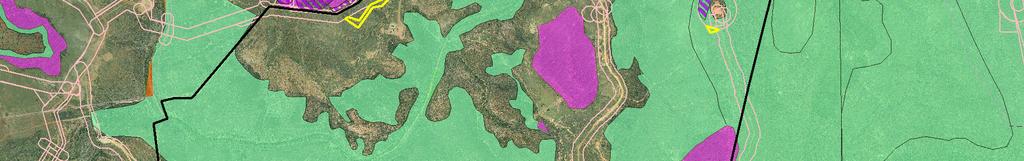
2 2.0.7/ /.0.3a /.0.3a.0./.0.3a.0./.0..0./.0. Endangered - Dominant Endangered - Sub-dominant Of Concern - Dominant Of Concern - Sub-dominant Not of Concern 20 FTY805 2 Area B 2.0./.0.3a /.0.3a Type A and EVNT's Ground Truth Areas EVNT Species Regions Watercourses V2. Upstream ground truth areas ESA Category A ESA Category B ESA Category C Regional Ecosystem (Biodiversity Status) Area C 6 CP a.9.4a.9.4a Area D a 6 A3 scale: :30, m 8 AB / Area E.0. Job No: Coordinate system: GDA 994 MGA Zone F Area.0./ a / a / / /.0. Notes: WT32.0./.0.3a a P:\Aurecon\25648 Santos\Mapping\6CP908635_Realignments_Overview.mxd 0/0/202 2:5:49 PM.9.4a.0./.0.3a 3 Map by: Moore NK.0./.0.3a.0./.0.3a.9.4a / /.0.3a.0./.0.3a P C a.0./.0.3a 2 5 WT27.0./.0.3a a / /.3.2 Legend.3.39/ / /.0.3a.0.7/ / / /.0.3a.0./.0.3a.0./.0.3a.0.7/ /.0.3a.0.3/ /.0.4 Area A.9.4a.0.7/ /.0.3a Date: 28/09/202 Version: Santos Ecological Assessment Report Lot 6 on CP Figure.: Lot Overview Map

3 Figure.2 Area A showing REs and location of Type A restricted plants.2 Floristics The footslopes on the western side of Area A have been previously cleared, and contained isolated mature trees and regrowth vegetation. The canopy layer of mature trees was sparse with approximately 5% cover, and consisted of Brachychiton populneus (Kurraong), Eucalyptus melanophloia (Silver leaved ironbar), Corymbia clarsoniana (Clarson s bloodwood) and Corymbia tessellaris (Moreton bay ash). The tree height ranged from 8 to 7 m, with an average height of 0 m. A lower tree layer (4 to 7 m high) was also evident, however it was sparse and provided approximately 5% cover. Species in this stratum included Eucalyptus melanophloia (Silver-leaved ironbar), Corymbia tessellaris (Moreton bay ash), Eucalyptus microcarpa (Grey box), Acacia leiocalyx (Blac wattle), Petalostigma pubescens (Quinine) and Geiera parviflora (Wilga), with some Croton insularis (Croton) occurring on the upper slope. A diverse range of species was present within the shrub layer, and included Dodonaea viscosa (Sticy hopbush), Eremophila mitchellii (False sandalwood), Grevillea striata (Beefwood), Geiera parviflora (Wilga), Senna artemisioides (Silver cassia), Cassinia laevis (Cough bush), Acacia decora (Pretty wattle), Capparis loranthifolia (Nipan), Alectryon oleifolius (Boonaree), Atalaya hemiglauca (Whitewood), Maytenus cunninghamii (Yellow berry bush), Carissa ovata (Currant bush) and Owenia Proect File Lot6CP908635_Memo_rev.docx October 202 Revision Page 2
, Aristida erichoensis (Jericho wiregrass), Sporobolus creber (Western rats tail grass), Enteropogon")
4 acidula (Emu apple). The shrub layer provided approximately 30% cover, and ranged in height from to 3 m. The ground layer was dominated by native grasses, including Bothriochloa bladhii (Forest bluegrass), Aristida erichoensis (Jericho wiregrass), Sporobolus creber (Western rats tail grass), Enteropogon ramosus (Twirly windmill grass), Chloris ventricosa (Tall chloris), Dichanthium sericeum (Queensland bluegrass), Themeda triandra (Kangaroo grass) and Cymbopogon refractus (Barbwire grass). Other associated ground layer species included Verbena tenuisecta (Mayne s curse), Senecio lautus (Fireweed), Cirsium vulgare (Spear thistle), Gomphocarpus physocarpus (Balloon cotton bush), Neptunia gracillis (Native sensitive plant), Pennisetum ciliare (Buffel grass), Oxalis stricta (Yellow wood sorrel) and Malvastrum americanum (Spiny malvastrum). The ground stratum provided approximately 85% cover, with a height range of 0.2 m to.2 m. Exotic species comprised approximately 5% of the total ground layer. An example of the vegetation located in the nant portion of Area A is shown in Photo.. Photo. Typical vegetation located on the nant footslope of Area A An area at the top of the ridge was also mapped as nant vegetation, and had been cleared in association with an existing quarry (Fairview West Quarry). The entire side of the ridge, from the quarry to the footslope, contained remnant vegetation. Along the top of the ridge, Acacia shirleyi (Lancewood), Corymbia clarsoniana (Clarson s bloodwood), Eucalyptus crebra (Narrow leaved ironbar) and Angophora leiocarpa (Smooth-bared apple) formed a canopy with a height range of 4 to 20 m and approximately 25% cover. Further down the slope, Eucalyptus crebra (Narrow leaved ironbar) became locally dominant. A lower tree layer of Callitris glaucophylla (White cypress pine) and Acacia leiocalyx (Blac wattle) dominated, with associated species including Lysicarpus angustifolius (Budgeroo), Jacsonia scoparia Proect File Lot6CP908635_Memo_rev.docx October 202 Revision Page 3
5 (Jacsonia), Bursaria spinosa (Pricly pine) and Owenia acidula (Emu apple). The sub-canopy stratum had a height range of 5 to 0 m, with an average height of 7 m. The shrub layer contained a diverse composition of species, including Alphitonia excelsa (Red ash), Callitris glaucophylla (White cypress pine), Acacia leiocalyx (Blac wattle), Psydrax oleifolia (Hatstand), Carissa ovata (Currant bush), Cassinia laevis (Cough bush), Geiera parviflora (Wilga), Dodonaea triangularis (Fan hopbush), Petalostigma pubescens (Quinine), Acacia complanata (Velvet wattle), Bachousia angustifolia (Grey mrytle) and Pittosporum spinescens (Wallaby apple). Table. provides the heights, Foliage Proective Cover (FPC) and stem counts calculated for the canopy, sub-canopy and shrub layers (adapted from Eyre et al 20, refer Appendix D). Table. Heights, FPC and stem counts for the remnant vegetation of Area A Stratum Height FPC (%) Stem count (stems/ha) Canopy 4-20 m Sub-canopy 5-0 m Shrub -3 m N/A 70 Some species nown to be associated with Semi-evergreen vine thicet (SEVT) were recorded in a sheltered gully within the area. These species included Croton insularis (Croton), Flindersia australis (Crows ash), Notelaea microcarpa (Native olive), Petalostigma pubescens (Quinine) and Carissa ovata (Currant bush). The canopy was still dominated by Eucalyptus crebra (Narrow leaved ironbar) which was the ecologically dominant layer (EDL). Therefore the area was not considered to be a SEVT threatened ecological community (TEC). The ground layer was diverse and dominated by native species. Species included Aristida calycina (Dar wiregrass), Aristida caput-medusa (Many-headed wiregrass), Eragrostis elongata (Clustered lovegrass), Swainsona luteola (Dwarf darling pea), Maireana microphylla (Small-leaf bluebush), Thyridolepis mitchelliana (Mulga mitchell grass), Sida fibulifera (Pin sida), Lomandra multiflora (Lomandra), Gahnia aspera (Gahnia), Enneapogon gracillis (Slender bottlewashers) and Keraudrenia collina (Keraudrenia). The RE on the lower slope in the northern portion of the remnant vegetation of Area A is mapped as.0.7/.0.4, while the remainder of the remnant vegetation is mapped as.0./.0.3a. Long descriptions of these REs are provided in Table.2. The vegetation on the lower slopes is consistent with the description for RE.0.7, while on the upper slopes the remnant vegetation closely resembled the description of RE.0.4a in the northern portion of Area F, and RE.0.7 in the southern portion. The vegetation present did not match the descriptions for RE.0. or.0.3, so the correct REs are considered to be RE.0.4a/.0.7 on the upper slopes, grading to RE.0.7 on the lower slopes. All of these REs have the same no concern at present biodiversity status. Proect File Lot6CP908635_Memo_rev.docx October 202 Revision Page 4
6 Table.2 Long descriptions of Res.0.,.0.4,.0.7 and.0.3, which are mapped in Area A RE Biodiversity Status Description.0. No concern at present.0.4 No concern at present Corymbia citriodora predominates and forms a distinct but discontinuous openforest (to woodland) canopy (20-30 m high). On rocy slopes, Eucalyptus crebra and C. hendersonii may be scattered throughout the canopy. On flats and footslopes, scattered E. crebra, C. clarsoniana and C. tessellaris may occur. Corymbia trachyphloia and E. cloeziana often occur on crests and plateaus while E. apothalassica and E. longirostrata sometimes occur in moister microhabitats. Scattered tall to low shrubs, such as Acacia leiocalyx, Acacia spp., Bursaria spinosa, Persoonia falcata, Alphitonia excelsa, Petalostigma pubescens and Xanthorrhoea ohnsonii are usually present and sometimes form a conspicuous layer. The ground layer varies from sparse to moderately dense (depending on the rociness) and is dominated by perennial grasses. Occurs on hills and ranges, particularly on colluvial lower slopes, formed from medium to coarse-grained sediments (usually sandstone). Associated soils are often texture contrast with a thin sandy or loamy surface horizon and some uniform sandy and lithosol soils. (BVGM: 0a) Maor vegetation communities include:.0.a: Corymbia watsoniana +/- C. citriodora, +/- C. trachyphloia +/- C. henryi woodland. (BVGM: 2a).0.b: Eucalyptus mediocris woodland. (BVGM: 2a).0.c: Eucalyptus fibrosa, Eucalyptus spp. woodland. (BVGM: 2a).0.d: Eucalyptus crebra woodland. (BVGM: 2a) Eucalyptus decorticans predominates forming a distinct but discontinuous canopy (25-30 m high). Eucalyptus decorticans usually forms pure stands, however other Eucalyptus spp. often form part of the canopy and dominate Other tree species that may be present and/or dominant include Acacia shirleyi, Angophora leiocarpa, Callitris glaucophylla, Eucalyptus apothalassica, Lysicarpus angustifolius, E. exserta, E. fibrosa subsp. nubila, E. panda, E. tenuipes, Corymbia trachyphloia, and E. virens. On very rocy shallow soils, Eucalyptus baeri, E. curtisii or E. viridis may occur. Acacia shirleyi is the most frequent tall shrub, although other Acacia spp. may be locally dominant. There is usually a low tree or tall shrub layer dominated by species such as Acacia sparsiflora, A. burrowii, Callitris endlicheri, Allocasuarina inophloia, Acacia spp., Eucalyptus tenuipes, Alphitonia excelsa and Petalostigma pubescens. A low shrub layer is not usually present, however where it occurs Acacia spp. and Dodonaea triangularis usually predominate. The ground layer is sparse to open, and dominated by perennial grasses, usually Aristida spp. or Arundinella nepalensis. Occurs on crests, scarps and upper slopes of ranges formed from medium to coarse-grained sediments with shallow soils. (BVGM: 2a) Maor vegetation communities include:.0.4a: Eucalyptus crebra, Corymbia aureola, C. clarsoniana and/or Acacia shirleyi woodland. Small areas that occur on conunction with E. decorticans woodland. (BVGM: 2a).0.4b: Eucalyptus crebra, Eucalyptus exserta woodland. Small areas that occur on conunction with E. decorticans woodland. Occurs on undulating terrain and occasionally on ridgetops. (BVGM: 2a).0.4c: Eucalyptus crebra, Corymbia hendersonii woodland. Small areas that occur on conunction with E. decorticans woodland. Occurs on undulating terrain and occasionally on ridgetops. (BVGM: 2a).0.4d: Flindersia collina +/- Eucalyptus crebra Occurs on steep hills and Proect File Lot6CP908635_Memo_rev.docx October 202 Revision Page 5
7 RE Biodiversity Status Description dissected plateaux (BVGM: 2a).0.7 No concern at present.0.3 No concern at present Eucalyptus crebra and/or E. melanophloia +/- E. populnea shrubby woodland. Eucalyptus melanophloia and/or E. crebra predominate and form a distinct but open canopy. E. populnea is commonly present and may be locally dominant particularly on lower slopes. A low tree to tall shrub layer usually dominated by a range of species including Eremophila mitchellii, Acacia decora, A. longispicata spp. longispicata and A. excelsa is present. A low shrub layer with Petalostigma pubescens and other species is formed in places. The ground layer is variable in cover and composition, but composed mainly of grasses. Occurs on the lower slopes of scarp retreats, associated with dissected tablelands. Associated soils are generally moderately deep, acidic, sandy, yellow earths and sandy-surfaced texture contrast soils formed from medium to coarse-grained sediments. (BVGM: 2a) Maor vegetation communities include:.0.7a: Eucalyptus crebra +/- Callitris glaucophylla +/- Angophora leiocarpa +/- Eucalyptus spp. woodland. Eucalyptus crebra predominates and forms a distinct but discontinuous canopy (6-20 m high). In places, Angophora leiocarpa forms part of the canopy. The low tree layer (2-6 m high) is dominated by Callitris glaucophylla. Scattered tall and low shrubs may be present. The ground layer is open to dense, and dominated by perennial grasses, usually Aristida spp. or Themeda triandra. Open-forest (to woodland) with a range of canopy species including Eucalyptus cloeziana, E. melanoleuca, E. sphaerocarpa, Corymbia bunites, C. hendersonii, C. trachyphloia, E. suffulgens, C. leichhardtii, C. citriodora, E. baileyana. Occurs on sandstone scarps and tablelands with shallow soils formed from medium to coarse-grained sediments. (BVGM: 2a) Maor vegetation communities include:.0.3a: Eucalyptus cloeziana +/- E. melanoleuca +/- Corymbia bunites +/- E. sphaerocarpa woodland to open-forest. (BVGM: 2a).0.3b: Corymbia leichhardtii woodland. (BVGM: 2a) An example of the vegetation located in the remnant vegetation within Area A is shown in Photo.2. Proect File Lot6CP908635_Memo_rev.docx October 202 Revision Page 6
 and Opuntia stricta (Pricly pear) were observed within the")
8 Photo.2 Typical vegetation located in the mapped remnant vegetation on the side of a ridge within Area A Opuntia tomentosa (Velvety tree pear) and Opuntia stricta (Pricly pear) were observed within the Area A proposed development area. These species are listed as Class 2 pests declared under the provisions of the Land Protection (Pest and Stoc Route Management) Act 2002 (LP Act). Twelve Type A restricted plants were recorded within Area A. Their GPS locations are provided in Table.3. An assessment of the relocation potential of each individual is provided as Appendix C. Table.3 Location of Type A restricted plants in Area A Species Brachychiton populneus Common name Kurraong Easting Northing (GDA94, zone 55) (GDA94, zone 55) insect attac evident on trun clear exudate insect attac - yellow exudate, holes in bar Kurraong Brachychiton populneus Kurraong Brachychiton populneus Comment Brachychiton populneus Kurraong uvenile Brachychiton populneus Kurraong plants 5 stems total insect attac - clear exudate, holes in trun Kurraong Brachychiton populneus Brachychiton populneus Kurraong plants 5 stems Brachychiton populneus Kurraong Brachychiton rupestris hybrid Proect File Lot6CP908635_Memo_rev.docx October 202 Revision Page 7
9 Species Common name Easting (GDA94, zone 55) Northing (GDA94, zone 55) Brachychiton populneus Kurraong Brachychiton populneus Kurraong Comment Brachychiton rupestris Narrow-leaved bottle tree growing amongst rocs Brachychiton populneus Kurraong No other species of conservation significance as listed under the provisions of the NC Act and/or the EPBC Act were recorded during site investigations. A list of botanical species recorded within the development area is provided in Appendix A..3 Habitat value The habitat value within the remnant portion of Area A is high. This area contains numerous living Angophora and Eucalyptus trees bearing hollows, fallen timber including hollow logs, and standing hollow stags, particularly near the top of the ridge. These may provide shelter and nesting opportunities for arboreal and terrestrial mammals, reptiles and hollow-dependent birds. Dense leaf litter in association with stands of Acacia shrubs may provide excellent habitat for reptiles. Additionally, the following features contribute to the high habitat value of the remnant portion of Area A: Canopy vegetation for shelter, foraging and perching purposes Fissured and peeling bar suitable for providing shelter opportunities for microbats, reptiles and invertebrates Fallen woody debris, including hollow logs suitable for providing shelter opportunities for small mammals and reptiles Rocy crevices and outcrops suitable for a range of reptiles The habitat value in the nant area on the footslope of Area A (the western portion adacent to Valley Run Road) is moderate, with fewer canopy trees, and no rocy crevices. However, abundant shrubs and ground cover was present at this location. Hollow logs scatter the ground, providing potential habitat for small to medium-sized mammals, and reptiles. Floristic diversity in the shrub layer is high, so would support a range of avian fauna. A list of incidental fauna species recorded within all development areas in this assessment is provided in Appendix B. Diggings typical of the Short-beaed Echidna (Tachyglossus aculeatus) were noted in the remnant portion of Area A. This species is listed as Special Least Concern under the provisions of the NC Act. No other fauna species of conservation significance as listed under the provisions of the NC Act and/or EPBC Act were observed within the proposed development area. 2 Ecological assessment of Area B, C, D & E 2. General Areas B, C, D and E are currently mapped as entirely nant vegetation on the Regional Ecosystem (RE) mapping, which is certified by the Department of Environment and Heritage Protection (DEHP). Ground-truthing of these areas confirmed the RE mapping to be correct. Proect File Lot6CP908635_Memo_rev.docx October 202 Revision Page 8

10 Areas B, C, D and E are shown in Figure 2., Figure 2.2, Figure 2.3, and Figure 2.4, respectively. Figure 2. Area B showing REs, ESAs and location of Type A restricted plants Proect File Lot6CP908635_Memo_rev.docx October 202 Revision Page 9

11 Figure 2.2 Area C showing REs, ESAs and location of Type A restricted plants Proect File Lot6CP908635_Memo_rev.docx October 202 Revision Page 0

12 Figure 2.3 Area D showing REs, ESAs and location of Type A restricted plants Proect File Lot6CP908635_Memo_rev.docx October 202 Revision Page

13 Figure 2.4 Area E showing REs, ESAs and location of Type A restricted plants There is a Category B ESA mapped 30 m to the south of Area E, which corresponds to the mapped remnant endangered RE.9.5. There is one mapped watercourse which intersects the proposed development area of Area E. This watercourse is classified as a Stream order. There are no mapped watercourses located within the other proposed development areas. A Stream order 2 watercourse occurs 50 m to the east of Area D. Area B was located within a previously developed well site, and was completely devoid of woody vegetation. Areas C to D were located on cleared undulating hills. A recently cleared corridor was observed at Area E, which followed the alignment of the proposed development area. Only a small section of Area E (near the access road) had not been cleared. 2.2 Floristics Area B was devoid of woody vegetation (refer Photo 2.). Canopy cover was largely absent in Areas C, D and E (refer Photo 2.2 and Photo 2.3), with the exception of one mature Geiera parviflora (Wilga) in Area C and one mature Eucalyptus decorticans (Gum-topped ironbar) in Area E. The shrub layer was generally sparse in each of these areas, but contained a range of species, including Dodonaea viscosa (Sticy hopbush), Eremophila mitchellii (False sandalwood), Eremophila longifolia (Emu bush), Geiera parviflora (Wilga), Cassinia laevis (Cough bush), Acacia decora (Pretty wattle), Capparis mitchellii (Bumble tree), Alectryon diversifolius (Scrub boonaree) Alectryon oleifolius (Boonaree), Proect File Lot6CP908635_Memo_rev.docx October 202 Revision Page 2
, Aristida erichoensis (Jericho wiregrass), Sporobolus creber (Western")
14 Atalaya hemiglauca (Whitewood), Maytenus cunninghamii (Yellow berry bush), Carissa ovata (Currant bush) and Owenia acidula (Emu apple). The ground layer contained a mix of native and non-native grasses, forbs and herbs, including Pennisetum ciliare (Buffel grass), Aristida erichoensis (Jericho wiregrass), Sporobolus creber (Western rats tail grass), Chloris ventricosa (Tall chloris), Dichanthium sericeum (Queensland bluegrass), Themeda triandra (Kangaroo grass) and Cymbopogon refractus (Barbwire grass). Other associated ground layer species included Verbena tenuisecta (Mayne s curse), Senecio lautus (Fireweed), Cirsium vulgare (Spear thistle), Gomphocarpus physocarpus (Balloon cotton bush), Oxalis stricta (Yellow wood Sorrel) and Malvastrum americanum (Spiny malvastrum). Opuntia tomentosa (Velvety tree pear) and Opuntia stricta (Pricly pear) were present as scattered individuals. These species are listed as Class 2 pests declared under the provisions of the Land Protection (Pest and Stoc Route Management) Act 2002 (LP Act). No flora species of conservation significance as listed under the provisions of the NC Act and/or the EPBC Act were recorded in Areas B, C, D or E during site investigations. However, it is noted that two Type A restricted plants were located outside, but very close to the development areas, as described in Table 2. (refer Figure 2.2 and Figure 2.3). Table 2. Type A restricted plants in the vicinity of Areas C and D Species Common name Easting (GDA94, zone 55) Northing (GDA94, zone 55) Location Brachychiton populneus Kurraong On eastern boundary of Area C Brachychiton rupestris Narrow-leaved Bottle Tree m east of Area D Photo 2. Area B Proect File Lot6CP908635_Memo_rev.docx October 202 Revision Page 3


15 Photo 2.2 Area D looing towards remnant vegetation to the east Photo 2.3 Area E (cleared corridor) Proect File Lot6CP908635_Memo_rev.docx October 202 Revision Page 4

16 2.3 Habitat Value The habitat value of Areas B, C, D and E is low, due to the lac of canopy cover, fissured tree bar, rocy crevices and coarse woody debris. The relatively diverse shrub layer would provide some shelter, nesting and food resources to avian fauna. Abundant grass tussocs in the ground layer may provide limited shelter for ground-dwelling mammals and reptiles, but leaf litter was generally sparse. Brown honeyeaters (Lichmera indistincta) were observed feeding upon the flowers of Eremophila longifolia (Emu bush) in Area C. One inactive bird nest, liely to be that of the Torresian crow (Corvus orru), was observed in the mature Eucalyptus decorticans (Gum-topped ironbar) in Area E. This tree was located at GPS location (GDA94, zone 55). 3 Ecological Assessment of Area F 3. General Area F is mapped as entirely remnant RE.0./.0., which is has a not of concern at present biodiversity status (Figure 3.). No mapped watercourses or ESAs intersect Area F. Area F was located on the top of a steep ridge next to an existing well site (FV-3-2,3,4). Figure 3. Area F showing REs, ESAs and location of Type A restricted plants Proect File Lot6CP908635_Memo_rev.docx October 202 Revision Page 5
17 3.2 Floristics The canopy layer within Area F ranged in height from 4 m to 8 m, with an average height of 6 m, and provided 0% cover. Canopy species consisted of Eucalyptus crebra (Narrow-leaved ironbar), Callitris glaucophylla (White cypress pine) and Corymbia clarsoniana (Clarson s bloodwood). C. glaucophylla and Ficus macrophylla (Moreton bay fig) occurred in the sub-canopy, at an average height of 6 m, with 20% canopy cover. The shrub layer provided 30% cover, with a height range of m to 3.5 m, and an average height of 2.5 m. Shrub species included Acacia leiocalyx (Blac wattle), Acacia longispicata (Slender-flowered wattle), Cupaniopsis anacarioides (Tuceroo), Alectryon olieofolius (Boonaree), Eucalyptus melanophloia (Silver-leaved ironbar), Petalostigma pubescens (Quinine) and Pittosporum spinescens (Wallaby apple). The ground layer was diverse, and dominated by native grasses and forbs, including Digitaria breviglumis (Finger grass), Austrostipa verticillata (Slender bamboo grass), Eragrostis alveiformis (Granite lovegrass), Aristida caput-medusa (Many-headed wiregrass), Lomandra multiflora (Lomandra), Lomandra leucocephala (Woollyhead matrush), Dianella longifolia (Dianella), Podolepis aceoides (Showy copperwire daisy), Eragrostis elongata (Clustered lovegrass), Sida hacettiana (Queensland hemp), Wahlenbergia gracilis (Sprawling bluebell), Triaphis mollis (Purple plume grass) and Eragrostis sororia (Blue lovegrass). The RE is mapped as.0., which is described as Corymbia citriodora open forest on coarsegrained sedimentary rocs, and has a no concern at present biodiversity status. Corymbia citridora was absent from the canopy, and the height of the ecologically dominant layer (EDL) was 4-8 m, which is lower than that described for this RE (20-30 m). Area F has a westerly aspect and occurs on the boundary with RE.0.7, which is mapped on the slopes to the west. This RE is described as Eucalyptus crebra woodland on coarse-grained sedimentary rocs and has a no concern at present biodiversity status. The long descriptions of each of these REs is provided in Table 3.. The EDL height described for RE.0.7a (6-20 m) is consistent with that present in Area F. Further, the dominant sub-canopy species in RE.0.7a is Callitris glaucophylla, which was present in Area F, albeit lower (6 m) than that recorded in the RE description (2-6 m). The structure and composition of the remnant vegetation in Area F more closely resembles that of RE.0.7a, rather than the mapped RE.0., therefore it is considered that the RE within Area F should be mapped as.0.7a. Both REs have the same biodiversity status. Proect File Lot6CP908635_Memo_rev.docx October 202 Revision Page 6
18 Table 3. Long descriptions of Res.0. and.0.7, which are mapped in or near Area F RE Biodiversity Status Description.0. No concern at present.0.7 No concern at present Corymbia citriodora predominates and forms a distinct but discontinuous openforest (to woodland) canopy (20-30m high). On rocy slopes, Eucalyptus crebra and C. hendersonii may be scattered throughout the canopy. On flats and footslopes, scattered E. crebra, C. clarsoniana and C. tessellaris may occur. Corymbia trachyphloia and E. cloeziana often occur on crests and plateaus while E. apothalassica and E. longirostrata sometimes occur in moister microhabitats. Scattered tall to low shrubs, such as Acacia leiocalyx, Acacia spp., Bursaria spinosa, Persoonia falcata, Alphitonia excelsa, Petalostigma pubescens and Xanthorrhoea ohnsonii are usually present and sometimes form a conspicuous layer. The ground layer varies from sparse to moderately dense (depending on the rociness) and is dominated by perennial grasses. Occurs on hills and ranges, particularly on colluvial lower slopes, formed from medium to coarse-grained sediments (usually sandstone). Associated soils are often texture contrast with a thin sandy or loamy surface horizon and some uniform sandy and lithosol soils. (BVGM: 0a) Maor vegetation communities include:.0.a: Corymbia watsoniana +/- C. citriodora, +/- C. trachyphloia +/- C. henryi woodland. (BVGM: 2a).0.b: Eucalyptus mediocris woodland. (BVGM: 2a).0.c: Eucalyptus fibrosa, Eucalyptus spp. woodland. (BVGM: 2a).0.d: Eucalyptus crebra woodland. (BVGM: 2a) Eucalyptus crebra and/or E. melanophloia +/- E. populnea shrubby woodland. Eucalyptus melanophloia and/or E. crebra predominate and form a distinct but open canopy. E. populnea is commonly present and may be locally dominant particularly on lower slopes. A low tree to tall shrub layer usually dominated by a range of species including Eremophila mitchellii, Acacia decora, A. longispicata spp. longispicata and A. excelsa is present. A low shrub layer with Petalostigma pubescens and other species is formed in places. The ground layer is variable in cover and composition, but composed mainly of grasses. Occurs on the lower slopes of scarp retreats, associated with dissected tablelands. Associated soils are generally moderately deep, acidic, sandy, yellow earths and sandy-surfaced texture contrast soils formed from medium to coarse-grained sediments. (BVGM: 2a) Maor vegetation communities include:.0.7a: Eucalyptus crebra +/- Callitris glaucophylla +/- Angophora leiocarpa +/- Eucalyptus spp. woodland. Eucalyptus crebra predominates and forms a distinct but discontinuous canopy (6-20 m high). In places, Angophora leiocarpa forms part of the canopy. The low tree layer (2-6 m high) is dominated by Callitris glaucophylla. Scattered tall and low shrubs may be present. The ground layer is open to dense, and dominated by perennial grasses, usually Aristida spp. or Themeda triandra. Opuntia stricta (Pricly pear) occurred as scattered individuals. This species is listed as a Class 2 pest declared under the provisions of the Land Protection (Pest and Stoc Route Management) Act 2002 (LP Act). An example of the vegetation located in Area F is shown in Photo 3.. Proect File Lot6CP908635_Memo_rev.docx October 202 Revision Page 7
 Woody debris (fallen timber and")
19 Photo 3. Typical vegetation within Area F 3.3 Habitat Value The habitat value of Area F is high, with a range of features providing important resources for native fauna. These include: Canopy cover suitable for the provision of shelter, foraging and perching Fissured tree bar Dense ground cover vegetation (eg grassy tussocs) Woody debris (fallen timber and hollow-bearing logs) Leaf litter Rocy crevices Scats of Trichosurus vulpecula (Brush-tailed possum) were noted within Area F. The area is also liely to support gliders. Incidental fauna records derived from the site investigation are provided in Appendix B. No fauna species of conservation significance as listed under the provisions of the NC Act and/or EPBC Act were observed within the proposed development area. 4 Conclusion Areas B, C, D and E of the proposed development area have been extensively cleared, and as a result are mapped as nant vegetation. Area A contains both remnant and nant vegetation, while Area F occurs entirely within remnant vegetation. The REs of remnant vegetation within Area A and Area F are both listed as no concern at present biodiversity status. Proect File Lot6CP908635_Memo_rev.docx October 202 Revision Page 8
20 No ESAs are mapped within the proposed development area. However, a category B ESA is mapped 60 m to the east of Area A, and a category B ESA is mapped 30 m to the south of Area E. A stream order watercourse intersects Area E. A Stream order watercourse is mapped 40 m to the west of Area A and a Stream order 2 watercourse is mapped 50 m to the east of Area D. Twelve Type A restricted plants were recorded in Area A. Evidence of one Special Least Concern species (Short-beaed echidna) was noted within Area A. No other flora or fauna species of conservation significance as listed under the NC Act and/or the EPBC Act were observed within the proposed development area. The overall habitat value was considered to be high in the remnant areas of Area A and Area F, and low to moderate in the nant areas of Areas B, C, D and E. 5 References Eyre, T.J., Kelly, A.L, Neldner, V.J., Wilson, B.A., Ferguson, D.J., Laidlaw, M.J. and Frans, A.J. (20). BioCondition: A Condition Assessment Framewor for Terrestrial Biodiversity in Queensland. Assessment Manual. Version 2.. Department of Environment and Resource Management (DERM), Biodiversity and Ecosystem Sciences, Brisbane. Pizzey G and Knight F, 997, Field Guide to the Birds of Australia, Harper Collins Publishers, Australia Proect File Lot6CP908635_Memo_rev.docx October 202 Revision Page 9
21 Appendix A Botanical species recorded within the proposed development area on Lot 6 on CP Family name Scientific name Common name Notes Adiantaceae Cheilanthes sieberi Mulga fern Amaranthaceae Achyranthes aspera Chaff flower Apiaceae Daucus glochidatus Wild carrot Apiaceae Hydrocotyle laxiflora Pennywort Apocynaceae Alstonia constricta Bitter bar Apocynaceae Carissa ovata Currant bush Apocynaceae Gomphocarpus physocarpus Balloon cotton bush Apocynaceae Marsdenia australis Marsdenia Apocynaceae Marsdenia lanceolata Marsdenia Apocynaceae Parsonsia lanceolata Money rope Non-native Asteraceae Bidens pilosa Cobblers pegs Non-native Asteraceae Calocephalus platycephalus Billy buttons Asteraceae Calotis cuneifolia Purple burr daisy Asteraceae Calotis lappulacea Yellow burr daisy Asteraceae Calotis scabiosifolia Rough daisy burr Asteraceae Cassinia laevis Cough bush Asteraceae Chrysocephalum apiculatum Yellow buttons Asteraceae Cirsium vulgare Spear thistle, blac thistle Non-native Asteraceae Conyza bonariensis Fleabane Non-native Asteraceae Cotula australis Carrot weed Asteraceae Flaveria australasica Speedy weed Asteraceae Podolepis aceoides Showy copper wire daisy Asteraceae Pterocaulon sphacelatum Apple bush Asteraceae Rhodanthe polyphylla Asteraceae Senico lautus Fireweed Asteraceae Sonchus oleraceus Sow thistle Non-native Asteraceae Xerochrysum bracteatum Everlasting daisy Proect File Lot6CP908635_Memo_rev.docx October 202 Revision Page 20
22 Family name Scientific name Common name Notes Cactaceae Opuntia stricta Pricly pear Non-native, LP Act Class 2 Weed Cactaceae Opuntia tomentosa Velvety tree pear Non-native, LP Act Class 2 Weed Campanulaceae Wahlenbergia communis Large bluebells Campanulaceae Wahlenbergia gracilis Sprawling bluebell Capparaceae Apophyllum anomalum Warrior bush Capparaceae Capparis canescens Wild orange Capparaceae Capparis loranthifolia Nipan, wait a while Capparaceae Capparis mitchellii Bumble fruit Celastraceae Elaeodendron australe var. integrifolium Celastraceae Maytenus cunninghamii Yellow berry bush Chenopodiaceae Chenopodium desertorum Desert goosefoot Chenopodiaceae Maireana microphylla Small-leaf bluebush Chenopodiaceae Sclerolaena birchii Galvanised burr Convolvulaceae Dichondra repens Kidney weed Cupressaceae Callitris glaucophylla White cypress pine Cyperaceae Cyperus difformis Dirty dora Cyperaceae Cyperus haspan Cyperaceae Fimbristylis dichotoma Fimbristylis Cyperaceae Gahnia aspera Gahnia Euphorbiaceae Croton insularis Silver croton Fabaceae - Senna artemisioides Senna Caesalpinioideae Fabaceae - Faboideae Desmodium varians Trefoil Fabaceae - Faboideae Glycine tabacina Glycine pea Fabaceae - Faboideae Hovea longipes Hovea Fabaceae - Faboideae Indigofera adesmiifolia Tic indigo Fabaceae - Faboideae Indigofera australis Austral indigo, hill indigo Fabaceae - Faboideae Indigofera hirsuta Hairy indigo Fabaceae - Faboideae Jacsonia scoparia Jacsonia Fabaceae - Faboideae Lotus australis Lotus, birdsfoot trefoil Proect File Lot6CP908635_Memo_rev.docx October 202 Revision Page 2
23 Family name Scientific name Common name Notes Fabaceae - Faboideae Swainsona galegifolia Swainsona Fabaceae - Faboideae Swainsona luteola Dwarf darling pea Fabaceae - Mimosoideae Acacia complanata Velvet wattle Fabaceae - Mimosoideae Acacia deanei Dean's wattle Fabaceae - Mimosoideae Acacia decora Pretty wattle Fabaceae - Mimosoideae Acacia excelsa Iron wood Fabaceae - Mimosoideae Acacia harpophylla Brigalow Fabaceae - Mimosoideae Acacia ucunda Hairy wattle Fabaceae - Mimosoideae Acacia leiocalyx Blac wattle Fabaceae - Mimosoideae Acacia longispicata Slender-flowered wattle Fabaceae - Mimosoideae Acacia macradenia Zigzag wattle Fabaceae - Mimosoideae Acacia shirleyi Lancewood Geraniaceae Erodium cicutarium Common stors bill Goodeniaceae Goodenia glabra Smooth goodenia Goodeniaceae Scaevola aemula Fairy fan-flower Juncaceae Juncus usitatus Juncus Lomandraceae Lomandra leucocephala Wooly-head mat rush Lomandraceae Lomandra multiflora Lomandra Luzuriagaceae Eustrephus latifolia Wombat berry Malvaceae Hibiscus brachysiphonius Bush hibiscus Malvaceae Hibiscus sturtii Hills hibiscus Malvaceae Malvastrum americanum Spiny malvastrum Non-native Malvaceae Sida cordifolia Flannel weed Non-native Malvaceae Sida fibulifera Pin sida Malvaceae Sida rohlenae Shrub sida Malvaceae Sida hacettiana Queensland hemp Meliaceae Owenia acidula Emu apple Mimosaceae Neptunia gracillis Native sensitive plant Moraceae Ficus macrophylla Moreton bay fig Myoporaceae Eremophila bignoniiflora Dogwood Myoporaceae Eremophila debilis Winter apple Myoporaceae Eremophila mitchellii False sandalwood Myoporaceae Myoporum acuminatum Boobialla Myoporaceae Myoporum montanum Western boobialla Proect File Lot6CP908635_Memo_rev.docx October 202 Revision Page 22
24 Family name Scientific name Common name Notes Myrtaceae Angophora leiocarpa Smooth-bared apple Myrtaceae Bachousia angustifolia Grey myrtle Myrtaceae Corymbia clarsoniana Clarson s bloodwood Myrtaceae Corymbia tessellaris Moreton bay ash Myrtaceae Eucalyptus crebra Narrow leaved ironbar Myrtaceae Eucalyptus decorticans Gum topped ironbar Myrtaceae Eucalyptus melanophloia Silver leaved ironbar Myrtaceae Eucalyptus microcarpa Gum topped box Myrtaceae Lysicarpus angustifolius Budgeroo Oleaceae Jasminum simplicifolium Native asmine Oleaceae Notelaea microcarpa Native olive Oxalidaceae Oxalis stricta Yellow wood sorrel Passifloraceae Passiflora aurantia var. Red passion flower aurantia Phormiaceae Dianella longifolia Dianella Picrodendraceae Petalostigma pubescens Quinine Pittosporaceae Bursaria spinosa Pricly pine Pittosporaceae Pittosporum spinescens Wallaby apple Plantaginaceae Plantago cunninghamii Sago weed Poaceae Aristida calycina Dar wiregrass Poaceae Aristida caput medusa Many-headed wire grass Poaceae Aristida holathera Tall wire grass Poaceae Aristida erichoensis Jericho wire grass Poaceae Aristida latifolia Feathertop aristida Poaceae Aristida platychaeta Curled wiregrass Poaceae Aristida ramosa Wire grass Poaceae Austrostipa verticillata Slender bamboo grass Poaceae Bothriochloa bladhii Forest bluegrass Poaceae Bothriochloa decipiens Pitted bluegrass Proect File Lot6CP908635_Memo_rev.docx October 202 Revision Page 23
25 Family name Scientific name Common name Notes Poaceae Chloris divaricata Windmill chloris, slender chloris Poaceae Chloris ventricosa Tall chloris Poaceae Cymbopogon refractus Barbwire grass Poaceae Dichanthium sericeum Queensland blue grass Poaceae Digitaria breviglumis Finger grass Poaceae Enneapogon gracillis Slender bottlewashers Poaceae Enneapogon pallidus Pale bottlewasher Poaceae Enneapogon polyphyllus Limestone bottlewasher Poaceae Enteropogon ramosus Twirly windmill grass Poaceae Eragrostis alveiformis Granite lovegrass Poaceae Eragrostis brownii Browns lovegrass Poaceae Eragrostis elongata Clustered lovegrass Poaceae Eragrostis sororia Blue eragrostis Poaceae Eulalia aurea Sily brown top grass Poaceae Melinis repens Red natal Non-native Poaceae Panicum decompositum Hairy panic Poaceae Panicum effusum Inquisitive grass Poaceae Pennisetum ciliare Buffel grass Non-native Poaceae Sporobolus caroli Fairy grass Poaceae Sporobolus creber Western rats tail grass Poaceae Themeda avenacea Wild oats grass Poaceae Themeda triandra Kangaroo grass Poaceae Thyridolepis mitchelliana Mulga mitchell grass Poaceae Triaphis mollis Purple plume grass Poaceae Urochloa mosambicensis Urochloa, sabi grass Proteaceae Grevillea striata Beefwood Proteaceae Haea lorea Bootlace oa Rhamnaceae Alphitonia excelsa Red ash Rubiaceae Asperula conferta Common woodruff Rubiaceae Psydrax odorata Lamboto, sweet Proect File Lot6CP908635_Memo_rev.docx October 202 Revision Page 24
26 Family name Scientific name Common name Notes susie Rubiaceae Psydrax oleifolia Canthium Rutaceae Flindersia australis Crows ash Rutaceae Flindersia collina Leopardwood Rutaceae Geiera parviflora Wilga Santalaceae Santalum lanceolatum Sandalwood Sapindaceae Alectryon diversifolius Scrub boonaree Sapindaceae Alectryon oleifolius Boonaree Sapindaceae Atalaya hemiglauca Whitewood Sapindaceae Cupaniopsis Tuceroo anacardioides Sapindaceae Dodonaea stenophylla Narrow leaf hopbush Sapindaceae Dodonaea triangularis Fan hopbush Sapindaceae Dodonaea viscosa Sticy hopbush Solanaceae Solanum esuriale Brown potato bush Solanaceae Solanum nigrum Blac nightshade Non-native Sterculiaceae Brachychiton populneus Kurraong NC Act Type A Species Sterculiaceae Keraudrenia collina Keraudrenia Tiliaceae Grewia latifolia Dysentery plant Verbenaceae Stachytarpheta Blue snaeweed Non-native amaicensis Verbenaceae Verbena officinalis Common verbena, native verbena Verbenaceae Verbena tenuisecta Mayne s curse Non-native Proect File Lot6CP908635_Memo_rev.docx October 202 Revision Page 25
27 Appendix B Incidental fauna recorded within the proposed development areas on Lot 6 on CP Scientific name Common name Birds Acanthiza chrysorrhoa Acanthiza reguloides Anthus australis Aquila audax Cacatua galerita Colluricincla harmonica Coracina novaehollandiae Corvus coronoides Corvus orru Coturnix pectoralis Coturnix ypsilophora Cracticus nigrogularis Cracticus torquatus Dacelo novaeguineae Dicaeum hirundinaceum Elanus axillaris Eolophus rosiecapilla Falco berigora Falco cenchroides Falco subniger Geopelia placida Gerygone albogularis Grallina cyanoleuca Gymnorhina tibicen Yellow-rumped thornbill Buff-rumped thornbill Australasian pipit Wedge-tailed eagle Sulphur-crested cocatoo Grey-shrie thrush Blac-faced cucoo-shrie Australian raven Torresian crow Stubble quail Brown quail Pied butcherbird Grey butcherbird Laughing ooaburra Mistletoebird Blac-shouldered ite Galah Brown falcon Naneen estrel Blac falcon Peaceful dove White-throated gerygone Magpie-lar Australian magpie Proect File Lot6CP908635_Memo_rev.docx October 202 Revision Page 26
28 Scientific name Lichenostomus leucotis Lichmera indistincta Malurus melanocephalus Manorina melanocephala Megalurus timoriensis Melithreptus albogularis Myiagra rubecula Nymphicus hollandicu Ocyphaps lophotes Pachycephala rufiventris Pardalotus striatus Phalacrocorax varius Philemon citreogularis Philemon corniculatus Platycercus adscitus Rhipidura fuliginosa Rhipidura leucophrys Smicrornis brevirostris Strepera graculina Taeniopygia bichenovii Thresiornis molucca Trichoglossus haematodus Zosterops lateralis Common name White-eared honeyeater Brown honeyeater Red-baced fairy wren Noisy miner Tawny grassbird White-throated honeyeater Leaden flycatcher Cocatiel Crested pigeon Rufous whistler Striated pardalote Pied cormorant Little friarbird Noisy friarbird Pale-headed rosella Grey fantail Willie wagtail Weebill Pied currawong Double-barred finch Australian white ibis Rainbow lorieet Silvereye Reptiles Carlia vivax Cryptoblepharus vigatus Eulamprus martini Rainbow sin Fence sin Sin Mammals Proect File Lot6CP908635_Memo_rev.docx October 202 Revision Page 27
29 Scientific name Oryctolagus cuniculus Tachyglossus aculeatus Trichosurus vulpecula Common name European rabbit* Short-beaed echidna^ (diggings) Brush-tailed possum (scats) Table notes: *Declared Class 2 Pest under the Land Protection (Pest and Stoc Route Management) Act 2002 ^ Special Least Concern species under the Nature Conservation Act 992 Proect File Lot6CP908635_Memo_rev.docx October 202 Revision Page 28
30 Appendix C Type A assessment Glossary of terms Term Translocation Relocation Definition The act of translocation is considered to be the deliberate transfer of plants or regenerative plant material from an ex situ collection or natural population to a location in the wild, including existing or new sites or those where the taxon is now locally extinct The deliberate transfer of plants or regenerative plant material from an ex situ collection or natural population to another locations. The relocation methodology will be primarily focused around the transplantation of seedlings or mature plants Proect File Appendix C - Type A assessment.docx October 202 Revision 0 Page
31 Bacground. Proect description Santos Ltd (Santos) has commissioned Aurecon Australia Pty Ltd (Aurecon) to undertae ecological investigations of proposed areas of development for the Fairview gas fields. Aurecon has also been engaged to assess the relocation potential of a range of Type A Restricted Plant species (Type A species) protected under the provisions of the Nature Conservation Act 992 (NC Act), in accordance with the GLNG Upstream Type A Restricted Plant Species Salvage Management Plan for the Coal Seam Gas Fields (The Salvage Management Plan) (Santos, 20). The Fairview gas fields are centred around the Inune area and are characterised by elevated sandstone ranges including the Carnarvon and Expedition Ranges and part of the Mount Hutton and Kongabula Ranges. The Dawson River and other smaller watercourses drain this area and the vegetation is dominated by Eucalyptus and White Cypress Pine woodland, Brigalow and Semievergreen Vine Thicet (Eddie, 2007). Much of this area has been subected to cattle grazing and other agricultural practices as well as previous development associated with the gas fields. However, a range of Type A Restricted plant species persist throughout both the disturbed and intact environments within the Fairview gas fields. The Salvage Management Plan provides a list of Type A species liely to be encountered within the GLNG Upstream gas fields (Refer Section 2 of The Salvage Management Plan). Common Type A species recorded within the Fairview gas fields include Bottle trees (Brachychiton rupestris, Brachychiton populneus and Brachychiton australis) Epiphytic orchids (Cymbidium species), and Grasstrees (Xanthorrhoea species). This report is specific to the proposed development area labelled as Area A on lot 6CP in Figure. of the memo..2 Purpose of this report The purpose of this report is to provide an assessment of the relocation potential of Type A species located within Area A on lot 6CP (herein referred to as the proposed development area ) (Figure. of the memo). This assessment, and the proposed management measures, has been undertaen in accordance with The Salvage Management Plan. This report does not mae any recommendation regarding the development in relation to any Santos environmental authorities or other approvals. Proect File Appendix C - Type A assessment.docx October 202 Revision 0 Page 2
32 2 Methodology The Type A species relocation assessments were undertaen in parallel to the ecological assessment of the proposed development area. These assessments were undertaen to determine the number of existing Type A species present within the development area, and their suitability for relocation from an ecological perspective. Safety, site accessibility and equipment availability/capacity were not considered as part of this assessment. Prior to maing a decision to relocate an individual Type A specimen, field representatives are required to undertae a ris assessment in accordance with the Santos Environment Health Safety Management System (EHSMS) to determine whether it is safe to proceed with the proposed relocation. GIS environmental layers showing the location of previously identified Type A species and high resolution aerial photography were uploaded onto a toughboo (C5 mobile clinical assistant CFT-00 Motion computing), with an integrated GPS used to capture individual specimens for assessment. Handheld Garmin GPS units (GPS map 76) were also used during the field investigations. It should be noted that while efforts were made to ensure the GPS coordinates provided in this report are accurate, a margin of error approximately +/- 5 m is expected due to the limitations of the devices used and the recording environment. Each individual specimen was logged and its GPS coordinates recorded using the toughboo. An assessment of the relocation potential of each specimen was undertaen based on lielihood of survival. Measurements were recorded for each relocatable specimen (i.e. height, canopy width and diameter at breast height) and specific relocation management requirements were recorded for each individual specimen. Proect File Appendix C - Type A assessment.docx October 202 Revision 0 Page 3
33 3 Results 3. Type A species within Area A The following sections outline the specific management requirements for each Type A species identified within the proposed development area. It is noted that some of the individuals located within the development area during these investigations were determined to not be suitable for relocation. Two (2) species were recorded within the proposed development area during these assessments: Brachychiton populneus (Kurraong) Brachychiton rupestris (Narrow-leaved Bottle Tree) The location of the Type A species is provided in Figure -2 of the memo. The morphometrics, condition assessment and management measures relevant to the relocation of each individual is provided in the table below. A photographic record of each individual plant is provided where available in following sections (Photo ). Photographic records are a required as part of the GLNG Upstream Type A Restricted Plant Species Salvage Management Plan for the Coal Seam Gas Fields (Santos, 20) (refer to Section of the Plan). 3.2 General management requirements Prior to relocating an individual Type A specimen, a field representative is required to undertae a ris assessment in accordance with the Santos Environment Health Safety Management System (EHSMS) to determine whether it is safe to proceed with the proposed relocation. The GLNG Upstream Type A Restricted Plant Species Salvage Management Plan for the Coal Seam Gas Fields (Santos, 20) outlines selected methods of obtaining plants for translocation/relocation, general standards and management measures pertaining to the translocation and relocation and of Type A species. All relocation and translocation activities are to be undertaen in accordance with the Salvage Management Plan. Proect File Appendix C - Type A assessment.docx October 202 Revision 0 Page 4
34 ID Species GPS ID/ Coordinate Photo No Comment Is plant salvageable? Easting Northing (Yes/No) If not, provide reason Management requirements Measurements (Disease, damaged, unliely to survive due to poor health, other - provide comments) (e.g. remove % foliage, maintain orientation, reduce number of stems etc.) Tree height (m) Tree width (m) (including foliage) Root ball width (m) Root ball depth (m) Significant habitat value (Nests, hollows etc) 489 Brachychiton populneus N/A Yes Remove 70% foliage, maintain orientation Brachychiton populneus N/A insect attac evident on trun - clear exudate No Damaged due to insect attac Remove 70% foliage, maintain orientation Brachychiton populneus N/A insect attac - yellow exudate, holes in bar No Damaged due to insect attac Remove 70% foliage, maintain orientation Brachychiton populneus N/A uvenile Yes Remove 70% foliage, maintain orientation Brachychiton populneus N/A 2 plants 5 stems total Yes Remove 70% foliage, maintain orientation Brachychiton populneus N/A insect attac - clear exudate, holes in trun No Damaged due to insect attac Remove 70% foliage, maintain orientation Brachychiton populneus plants 5 stems Yes Remove 70% foliage, maintain orientation Brachychiton populneus Brachychiton rupestris hybrid Yes Remove 70% foliage, maintain orientation Brachychiton populneus Yes Remove 70% foliage, maintain orientation Brachychiton populneus Yes Remove 70% foliage, maintain orientation Brachychiton populneus Yes Remove 70% foliage, maintain orientation Brachychiton rupestris growing amongst rocs Yes Remove 70% foliage, maintain orientation Proect Proect No File Appendix C - Type A assessment.docx Select Date Revision 0 Page 5


 Plant ID 500 Proect")

35 Photo 3. Photo 3.2 Brachychiton populneus (Kurraong) Plant ID 4977 Brachychiton populneus Plant ID 4978 Photo 3.3 Brachychiton populneus Plant ID 4979 Photo 3.5 Brachychiton populneus (uvenile) Plant ID 50 Photo 3.4 Brachychiton populneus Plant ID 4980 Photo 3.6 Brachychiton rupestris (uvenile) Plant ID 500 Proect Proect No File Appendix C - Type A assessment.docx Select Date Revision 0 Page 6
T F E W aurecongroup.com. Pages (including this page)
") Aurecon Australia Pty Ltd ABN 54 005 139 873 Level 14, 32 Turbot Street Brisbane QLD 4000 Loced Bag 331 Brisbane QLD 4001 Australia T +61 7 3173 8000 F +61 7 3173 8001 E brisbane@aurecongroup.com W aurecongroup.com
Aurecon Australia Pty Ltd ABN 54 005 139 873 Level 14, 32 Turbot Street Brisbane QLD 4000 Loced Bag 331 Brisbane QLD 4001 Australia T +61 7 3173 8000 F +61 7 3173 8001 E brisbane@aurecongroup.com W aurecongroup.com
T F E W aurecongroup.com. Pages (including this page)
") Aurecon Australia Pty Ltd ABN 54 005 139 873 Level 14, 32 Turbot Street Brisbane QLD 4000 Locked Bag 331 Brisbane QLD 4001 Australia T +61 7 3173 8000 F +61 7 3173 8001 E brisbane@aurecongroup.com W aurecongroup.com
Aurecon Australia Pty Ltd ABN 54 005 139 873 Level 14, 32 Turbot Street Brisbane QLD 4000 Locked Bag 331 Brisbane QLD 4001 Australia T +61 7 3173 8000 F +61 7 3173 8001 E brisbane@aurecongroup.com W aurecongroup.com
T F E W aurecongroup.com. Pages (including this page)
") Aurecon Australia Pty LtdAurecon Australia Pty Ltd ABN 54 005 139 873 Level 14, 32 Turbot Street Brisbane QLD 4000 Loced Bag 331 Brisbane QLD 4001 Australia T +61 7 3173 8000 F +61 7 3173 8001 E brisbane@aurecongroup.com
Aurecon Australia Pty LtdAurecon Australia Pty Ltd ABN 54 005 139 873 Level 14, 32 Turbot Street Brisbane QLD 4000 Loced Bag 331 Brisbane QLD 4001 Australia T +61 7 3173 8000 F +61 7 3173 8001 E brisbane@aurecongroup.com
Roma Ecological Assessment Report Lot 28 WV433 Water to Grade Pipeline Corridor Investigations Santos Ltd
 Roma Ecological Assessment Report Lot 28 WV433 Water to Grade Pipeline Corridor Investigations Santos Ltd Report ref: 221708-001 30 June 2011 Revision 1 Document prepared by: Australia Pty Ltd ABN 54 005
Ecological Assessment Report Water to Grade Pipeline Corridor Investigations Lot 6CP Santos
 Ecological Assessment Report Water to Grade Pipeline Corridor Investigations Lot 6CP908635 Santos Report ref: 221708 10 June 2011 Revision 0 Document prepared by: Aurecon Australia Pty Ltd ABN 54 005 139
T F E W aurecongroup.com. Pages (including this page)
") Aurecon Australia Pty Ltd ABN 54 005 139 873 Level 14, 32 Turbot Street Brisbane QLD 4000 Locked Bag 331 Brisbane QLD 4001 Australia T +61 7 3173 8000 F +61 7 3173 8001 E brisbane@aurecongroup.com W aurecongroup.com
Aurecon Australia Pty Ltd ABN 54 005 139 873 Level 14, 32 Turbot Street Brisbane QLD 4000 Locked Bag 331 Brisbane QLD 4001 Australia T +61 7 3173 8000 F +61 7 3173 8001 E brisbane@aurecongroup.com W aurecongroup.com
Important grasses for northern (n), central (c) and southern (s) Queensland
, central (c) and southern (s) Queensland") Important grasses for northern (n), central (c) and southern (s) Queensland Desirable perennial grasses Black speargrass Buffel grass Desert bluegrass/forest Mitchell Early spring grass Forest bluegrass
Important grasses for northern (n), central (c) and southern (s) Queensland Desirable perennial grasses Black speargrass Buffel grass Desert bluegrass/forest Mitchell Early spring grass Forest bluegrass
Ecological Investigation HCS-05 Fairview Gas Fields Santos Ltd. Report ref: /001 1 June 2011 Revision 1
 Ecological Investigation HCS-05 Fairview Gas Fields Santos Ltd Report ref: 221708/001 1 June 2011 Revision 1 Document prepared by: Australia Pty Ltd ABN 54 005 139 873 Level 1, Tennyson House 9 Tennyson
Project No Project: Fairview Ecological Assessment Report Lots 7 WT258 and 11 WT15
 Project No. 221708-001 Project: Fairview Ecological Assessment Report Lots 7 WT258 and 11 WT15 Prepared for: Santos Ltd 8 August 2011 Document Control Record Document prepared by: Aurecon Australia Pty
Project: Fairview Ecological Assessment Report
 Project: Fairview Ecological Assessment eport Lot 6 on CP908635 Post Site-scout ealignment eport Project No. 22708 Prepared for: Santos Ltd eport ref: 22708 8 October 20 Document Control ecord Document
Report ref: June 2011 Revision 0. Santos Fairview Lot5 Ecological Assessment Water to Grade Pipelines
 Santos Fairview Lot5 Ecological Assessment Water to Grade Pipelines Report ref: 221708 1 June 2011 Revision 0 Document prepared by: Aurecon Australia Pty Ltd ABN 54 005 139 873 Level 1, Tennyson House
Document Control Record
 Project: Roma Ecological Assessment Report Lots 1 & 2 SP186211 Project No. 221708-001 Prepared for: Santos Ltd 25 August 2011 Document Control Record Document prepared by: Aurecon Australia Pty Ltd ABN
QuA part Gently undulating
 Geomorphic category Land system Terrain Quartz sandstone QhMe Hilly dissected Hilly to rolling QuA part Gently undulating Quartzose sandstone QuA part, QrCp Rolling to gently undulating I d % > Soils Vegetation
Ecological Assessment Report Water to Grade Pipeline and Road Upgrade Corridor Investigations Santos Lot 4 on WT217
 Ecological Assessment eport Water to Grade Pipeline and oad Upgrade Corridor Investigations Santos Lot 4 on WT217 eport ref: 221708 2 June 2011 evision 0 Document prepared by: Aurecon Australia Pty Ltd
Project No
 Project: Fairview Ecological Assessment eport Geotech Sites 6399-M-45, 6399-M-49, 6399-TP- 97 andd TP-F230 Project No. 221708-001 Prepared for: Santos Ltd 11 August 2011 Document Control ecord Document
Plants of Columboola
 Plants of Columboola All photos which are the property of the author (i.e. not otherwise attributed) may be reused without attribution for non-commercial purposes. 3 A resource developed in consultation
Grasses of Mt Gravatt Conservation Reserve
 Compiled by Michael Fox www.megoutlook.wordpress.com/flora-fauna/ 2014 Creative Commons free use with attribution to Mt Gravatt Environment Group Alloteropsis semialata Cockatoo Grass Andropogon virginicus
Ecological Assessment Report FV18-26 (Strathblane)
") Ecological Assessment Report FV18-26 (Strathblane) Date Rev Reason For Issue Author Checked Approved 16/02/2014 A Draft SL LS VK 20/02/2014 B Draft SL LS VK 07/03/2014 0 Final SL LS VK 1 Contents Abbreviations...
Ecological Assessment Report FV18-26 (Strathblane) Date Rev Reason For Issue Author Checked Approved 16/02/2014 A Draft SL LS VK 20/02/2014 B Draft SL LS VK 07/03/2014 0 Final SL LS VK 1 Contents Abbreviations...
Vegetation Identification
 Vegetation Identification Contents Plant Pages Native trees 2 6 Native shrubs 7-9 Introduced plants 10-16 Version 1 1 Casuarina glauca Casuarinaceae Swamp Oak A slender tree, usually growing to 20m high,
Preliminary Vegetation Map and Floristics of Killarney Wilderness Retreat
 Preliminary Vegetation Map and Floristics of Killarney Wilderness Retreat Dr John T. Hunter June 2014 23 Kendall Rd, Invergowrie NSW, 2350 Ph. & Fax: (02) 6775 2452 Email: jhunter8@bigpond.com i Vegetation
NATIVE PASTURE IDENTIFICATION, ESTABLISHMENT AND MANAGEMENT IN NORTHERN VICTORIA. Eris O Brien- March 2012
 NATIVE PASTURE IDENTIFICATION, ESTABLISHMENT AND MANAGEMENT IN NORTHERN VICTORIA Eris O Brien- March 2012 Summary My Background Native Pasture Identification Common native pasture plants, key characteristics
Alice Clays. Average slope. Soil permeability. Inundation risk. Very low. Soil depth. Very deep; m. Wind erosion. Moderate
 Land system name: Land unit: Alice Clays AC1 General description This land unit represents the gentle lower slopes of an alluvial fan, which overlies an old lakebed clay. The depth to these clays may be
Casuarina glauca. Family: Casuarinaceae. Common Name: Swamp Oak
 Casuarina glauca Casuarinaceae Swamp Oak A slender tree, usually growing to 20m high, with drooping, blue-grey foliage. Branchlets grow to14cm long and cones are warty and 15-33mm in length. Grows in brackish
Friends of Black Mountain Coordinating Group, 11 August 2013
 Friends of Black Mountain and Friends of the Australian National Botanic Gardens: Overview of outcomes from weeding activities in the Australian National Botanic Gardens, March July 2013 Friends of Black
HILL WALK Self-guided Trail
 HILL WALK Self-guided Trail This hill is a very important cultural site for Arrernte people, and we ask that visitors keep to the path. There is a sign at the top of the hill that gives more information
SMALL TREES & LARGE SHRUBS
 Acacia longifolia subsp. sophorae (Mimosaceae) Coast Wattle Size: Large bushy spreading shrub to 5m. Flowering: July - October. Habitat: Common in well-drained coastal areas particularly west of Portland
Australian Plants Junior Primary Student Guide
 Australian Plants Junior Primary Student Guide Junior Primary N Botanic Park 1 2 3 Adelaide Botanic Garden 4 5 6 7 Hackney Road Friends Gate Toilets Plane Tree Drive 11 10 8 9 Toilets Toilets Restaurant
Common Name: ALABAMA WARBONNET. Scientific Name: Jamesianthus alabamensis Blake & Sherff. Other Commonly Used Names: Jamesianthus
 Common Name: ALABAMA WARBONNET Scientific Name: Jamesianthus alabamensis Blake & Sherff Other Commonly Used Names: Jamesianthus Previously Used Scientific Names: none Family: Asteraceae/Compositae (aster)
Mulga. Blackwood. Acacia aneura. Acacia melanoxylon
 Mulga Acacia aneura Aboriginal people have used the hard wood of their local variety of Mulga to make spears, digging sticks and long narrow shields. Mulga seeds can be eaten after cleaning and grinding
GLOSSARY Last Updated: 10/17/ KL. Terms and Definitions
 GLOSSARY Last Updated: 10/17/2017 - KL Terms and Definitions Spacing 4ETa Zone(s) Background Drill Elevation Climate Soil Ecoregion 4 Recommended base spacing between containerized, cutting, plug or sprig
Gray Flycatcher Empidonax wrightii
 Photo by Fred Petersen Habitat Use Profile Habitats Used in Nevada Pinyon-Juniper Sagebrush Montane Shrubland Key Habitat Parameters Plant Composition Pinyon pine, juniper, tall sagebrush species, bitterbrush,
agronomy Grassy Weeds
 agronomy OCTOBER 2018 SOUTH DAKOTA STATE UNIVERSITY AGRONOMY, HORTICULTURE & PLANT SCIENCE DEPARTMENT Grassy Weeds Review and Revision: Paul O. Johnson SDSU Extension Weed Science Coordinator Original
Land system name: Badlands. Land unit:
 Land system name: Land unit: Badlands BD3 General description This land unit represents a complex of soil-vegetation associations, which have formed on the dissected landscape sloping away from the scarp
Appendix 9 Vegetation of Day Creek and
 Appendix 9 Vegetation of Day Creek and Associated Floodplain (Desert Wildlife Services, October 2016) GHD Report for Arafura Resources Ltd Nolans Project Supplement Report, 4322529 VEGETATION OF DAY CREEK
Common Name: VIRGINIA SPIRAEA. Scientific Name: Spiraea virginiana Britton. Other Commonly Used Names: Appalachian spiraea
 Common Name: VIRGINIA SPIRAEA Scientific Name: Spiraea virginiana Britton Other Commonly Used Names: Appalachian spiraea Previously Used Scientific Names: none Family: Rosaceae (rose) Rarity Ranks: G2/S1
Sheet1. Page 1. Nyalar Mirungan-ah Nature Refuge 01/02/13
 Nyalar Mirungan-ah Nature Refuge 01/02/13 Scientific Name Acacia decora Acacia melanoxylon Ajuga australis Alocasia brisbanensis Amyema miquelii Angophora floribunda Aristida gracilis Arthropidium fimbriatus?
Land system name: Northern Plateau
 Land system name: Land unit: Northern Plateau NP1 General description This land unit represents an extensive area of crests and upper slopes in a landscape of gentle-rises. The soils are typically shallow,
Adnyamathanha plant uses
 Adnyamathanha plant uses Images and information compiled courtesy of Rosemary Pedler s Wildflowers of the Northern Flinders Ranges and Wildflowers of the Southern Flinders Ranges, Australian National Botanic
Other Commonly Used Names: Fremont s virgins-bower, Fremont s clematis, Fremont s curly-heads
 Common Name: FREMONT S LEATHER FLOWER Scientific Name: Clematis fremontii S. Watson Other Commonly Used Names: Fremont s virgins-bower, Fremont s clematis, Fremont s curly-heads Previously Used Scientific
Common Name: AMERICAN MOUNTAIN-ASH
 Common Name: AMERICAN MOUNTAIN-ASH Scientific Name: Sorbus americana Marshall Other Commonly Used Names: American rowan Previously Used Scientific Names: Pyrus microcarpa (Pursh) Sprengel, Pyrus americana
BUTTERFLY IDENTIFICATION CHART Sheet 1. MOSTLY BROWN or ORANGE Medium sized butterflies - 25mm - 60mm wingspan MY BUTTERFLY IS:
 BUTTERFLY IDENTIFICATION CHART Sheet 1 Diamond Sand-skipper Antipoda atralba - occurs along coastal cliffs south of Adelaide and in pristine heathland in the Hills. Caterpillars are found on small species
Common Name: ALABAMA LEATHER FLOWER. Scientific Name: Clematis socialis Kral. Other Commonly Used Names: none. Previously Used Scientific Names: none
 Common Name: ALABAMA LEATHER FLOWER Scientific Name: Clematis socialis Kral Other Commonly Used Names: none Previously Used Scientific Names: none Family: Ranunculaceae (buttercup) Rarity Ranks: G1/S1
Common Name: VARIABLE-LEAF INDIAN-PLANTAIN. Scientific Name: Arnoglossum diversifolium (Torrey & Gray) H.E. Robinson. Other Commonly Used Names: none
 H.E. Robinson. Other Commonly Used Names: none") Common Name: VARIABLE-LEAF INDIAN-PLANTAIN Scientific Name: Arnoglossum diversifolium (Torrey & Gray) H.E. Robinson Other Commonly Used Names: none Previously Used Scientific Names: Cacalia diversifolia
Common Name: VARIABLE-LEAF INDIAN-PLANTAIN Scientific Name: Arnoglossum diversifolium (Torrey & Gray) H.E. Robinson Other Commonly Used Names: none Previously Used Scientific Names: Cacalia diversifolia
! " Alternatives to Ash: Native Trees for Southern Wisconsin" Compiled by the UW Madison Arboretum! January, 2014!
 " Alternatives to Ash: Native Trees for Southern Wisconsin" Compiled by the UW Madison Arboretum January, 2014 The UW Madison Arboretum recommends planting native tree species to replace ash trees (Fraxinus
Erosion Hazard (Off-Road, Off-Trail) Angelina County, Texas (Upland Island Erosion Hazard (Off-Road, Off-Trail))
 Angelina County, Texas (Upland Island Erosion Hazard (Off-Road, Off-Trail))") Cypress Creek Erosion Hazard (Off-Road, Off-Trail) Angelina County, Texas () 31 7' 50'' 31 4' 50'' 3439500 3440400 3441300 3442200 3443100 3444000 3444900 94 24' 48'' 94 24' 51'' 365700 Graham Creek 365700
Cypress Creek Erosion Hazard (Off-Road, Off-Trail) Angelina County, Texas () 31 7' 50'' 31 4' 50'' 3439500 3440400 3441300 3442200 3443100 3444000 3444900 94 24' 48'' 94 24' 51'' 365700 Graham Creek 365700
Common Name: GEORGIA ROCKCRESS. Scientific Name: Arabis georgiana Harper. Other Commonly Used Names: none. Previously Used Scientific Names: none
 Common Name: GEORGIA ROCKCRESS Scientific Name: Arabis georgiana Harper Other Commonly Used Names: none Previously Used Scientific Names: none Family: Brassicaceae/Cruciferae (mustard) Rarity Ranks: G1/S1
Previously Used Scientific Names: Kalmia angustifolia var. carolina (Small) Fernald
 Fernald") Common Name: CAROLINA BOG LAUREL Scientific Name: Kalmia carolina Small Other Commonly Used Names: Carolina bog myrtle, Carolina wicky, Carolina lamb-kill, Carolina sheep-laurel Previously Used Scientific
Common Name: CAROLINA BOG LAUREL Scientific Name: Kalmia carolina Small Other Commonly Used Names: Carolina bog myrtle, Carolina wicky, Carolina lamb-kill, Carolina sheep-laurel Previously Used Scientific
Ravenswood. Average slope. Soil permeability. Slowly permeable. Inundation risk. Low. Soil depth. Very deep; m. Wind erosion.
 Land system name: Land unit: Ravenswood RD2 General description This land unit represents the moderately-well, and well-drained Vertosols (uniform clay soils), which have been modified to varying extents
Tree identification manual. For the north-east Darling Downs region
 Tree identification manual For the north-east Darling Downs region First published 1993 This edition edited and published by North East Downs Landcare Group 2011, with funding from the Australian Government
Common shrubs shrub-steppe habitats
 Common shrubs shrub-steppe habitats Photos (unless noted) by Susan Ballinger Sources for text include: http://biology.burke.washington.edu/herbarium/imagecollection.php Flora of the Pacific Northwest by
CONTROLLING ACACIA SALIGNA AROUND THE LOWER LAKES
 CONTROLLING ACACIA SALIGNA AROUND THE LOWER LAKES What is Acacia saligna? The common name for Acacia saligna is Golden Wreath Wattle. What it looks like The Golden Wreath Wattle grows as a large shrub
Biodiversity Assessment within the Nillumbik Indigenous Plants Park
 Biodiversity Assessment within the Nillumbik Indigenous Plants Park A list of findings by Chantelle Ebony Roberts and Georgia Lloyd, 2015 RESEARCH FOCUS Recording and repairing the flora and fauna within
Converse County Conservation District
 Converse County Conservation District Perennial Info Sheet Lanceleaf Coreopsis Coreopsis lanceolata Description: A clump forming perennial plant, with bright yellow, 1-2 inch diameter flowers forming from
T. Anders Guttiferae. Garcinia livingstonei. LOCAL NAMES English (wild plum,wild mangosteen,low veld mangosteen); Swahili (mutumbi,mpekechu)
; Swahili (mutumbi,mpekechu)") LOCAL NAMES English (wild plum,wild mangosteen,low veld mangosteen); Swahili (mutumbi,mpekechu) BOTANIC DESCRIPTION is a shrub or small evergreen tree to 10 m; crown dense, spreading or conical; trunk
LOCAL NAMES English (wild plum,wild mangosteen,low veld mangosteen); Swahili (mutumbi,mpekechu) BOTANIC DESCRIPTION is a shrub or small evergreen tree to 10 m; crown dense, spreading or conical; trunk
HISTORY USES AND HEALTH BENEFITS. Figure 31. Nanking cherries
 nanking cherries Nanking cherries (Prunus tomentosa) are shrubs that grow from three feet up to ten feet tall with twigs that usually occupy an area twice as wide as the plant is tall. Up to 20 canes can
Summary of Plants learned in this lab: Family Genus Species. ASCLEPIADACEAE Cynanchum barbigerum. ASTERACEAE Verbesina encelioides
 Packet #2 Brackenridge Field Laboratory (BFL) September 29 th Page 1 of 9 Summary of Plants learned in this lab: Family Genus Species ASCLEPIADACEAE Cynanchum barbigerum ASTERACEAE Verbesina encelioides
Identification of Grass Weeds in Florida Citrus1
 HS955 1 Stephen H. Futch and David W. Hall2 Grass weeds commonly found in citrus can be identified by looking for specific characteristics of the plant. These specific characteristics can include, but
Other Commonly Used Names: trailing spiny-pod, sandhill spiny pod
 Common Name: TRAILING MILKVINE Scientific Name: Matelea pubiflora (Decaisne) Woodson Other Commonly Used Names: trailing spiny-pod, sandhill spiny pod Previously Used Scientific Names: Edisonia pubiflora
Non-Native Invasive Plants
 Non-Native Invasive Plants Identification Cards EMPACTS Project Plant Biology, Fall 2013 Kurtis Cecil, Instructor Northwest Arkansas Community College Bentonville, AR EMPACTS Team - Justin Klippert, Holly
Malvaceae mallow family
 Malvaceae mallow family A large family, it includes prized ornamentals such as hibiscus and the textile cotton. Nova Scotia has but two genera of the 75 known. Ours are escaped garden flowers and weedy
(Boj.) Pichon Apocynaceae. Saba comorensis. LOCAL NAMES English (rubber vine); Swahili (mpira,mbungo)
 Pichon Apocynaceae. Saba comorensis. LOCAL NAMES English (rubber vine); Swahili (mpira,mbungo)") LOCAL NAMES English (rubber vine); Swahili (mpira,mbungo) BOTANIC DESCRIPTION is a strong forest liana up to 20 m long on other trees. Stem lenticillate and exuding a white sticky latex when cut. Leaves
LOCAL NAMES English (rubber vine); Swahili (mpira,mbungo) BOTANIC DESCRIPTION is a strong forest liana up to 20 m long on other trees. Stem lenticillate and exuding a white sticky latex when cut. Leaves
Erosion Hazard (Road, Trail) Angelina County, Texas (Upland Island Erosion Hazard (Road, Trail)) Web Soil Survey National Cooperative Soil Survey
 Angelina County, Texas (Upland Island Erosion Hazard (Road, Trail)) Web Soil Survey National Cooperative Soil Survey") Cypress Creek Erosion Hazard (Road, Trail) Angelina County, Texas () 31 7' 50'' 31 4' 50'' 3439500 3440400 3441300 3442200 3443100 3444000 3444900 94 24' 48'' 94 24' 51'' 365700 Graham Creek 365700 366600
Cypress Creek Erosion Hazard (Road, Trail) Angelina County, Texas () 31 7' 50'' 31 4' 50'' 3439500 3440400 3441300 3442200 3443100 3444000 3444900 94 24' 48'' 94 24' 51'' 365700 Graham Creek 365700 366600
Evergreen Huckleberry Vaccinium ovatum
 Evergreen Huckleberry Vaccinium ovatum Evergreen huckleberry grows at low elevations from British Columbia, through Washington and Oregon, and south into California. Evergreen huckleberry is an erect,
Hochst. Euphorbiaceae. Croton sylvaticus
 LOCAL NAMES Afrikaans (boskoorsbessie); English (woodland croton,forest fever berry); Xhosa (umfeze,umagwaqane); Zulu (umzilanyoni,umhloshazane,ugebeleweni,indulambahlozi) BOTANIC DESCRIPTION Croton sylvaticus
Client Wildscape for the Property Situated at: 5 Apbiol Road
 Client Wildscape for the Property Situated at: 5 Apbiol Road N Property Situated at 5 Apbiol Road Property Situated at 5 Apbiol Road Double-Lot Dimensions 285 370 385 370 Desired Animal Visitors Eastern
Carex kobomugi (Japanese sedge Asiatic sand sedge )
") 1 of 6 9/24/2007 3:33 PM Home Early Detection IPANE Species Data & Maps Volunteers About the Project Related Information Catalog of Species Search Results :: Catalog of Species Search Carex kobomugi (Japanese
1 of 6 9/24/2007 3:33 PM Home Early Detection IPANE Species Data & Maps Volunteers About the Project Related Information Catalog of Species Search Results :: Catalog of Species Search Carex kobomugi (Japanese
Common Name: BUTTERNUT
 Common Name: BUTTERNUT Scientific Name: Juglans cinerea Linnaeus Other Commonly Used Names: white walnut, oilnut Previously Used Scientific Names: Wallia cinerea (Linnaeus) Alefeld Family: Juglandaceae
Land system name: Corea. Land unit:
 Land system name: Land unit: Corea CA2 General description This land unit represents a section of an extensive plain, characterised mostly by deep sandy gradational-textured soils and ironbark woodlands.
Utah. White Rock Range Wilderness Study Area Site-Specific Monitoring Guide
 Utah White Rock Range Wilderness Study Area Site-Specific Monitoring Guide 0 General Information WildSNAP Monitoring Peter Woodruff, American Conservation Experience Coordinator Phone (801) 989-7069 Main
Ep161 More Spring West (0.4 ha) TL
 TL") Ep161 More Spring West (0.4 ha) TL 524107 Hornbeam (Carpinus betulus) and Field Maple (Acer campestre) are the main components of this narrow strip of woodland. Hawthorn (Crataegus monogyna) is frequent
Ep161 More Spring West (0.4 ha) TL 524107 Hornbeam (Carpinus betulus) and Field Maple (Acer campestre) are the main components of this narrow strip of woodland. Hawthorn (Crataegus monogyna) is frequent
Hayward Shoreline Wildflowers
 Hayward Shoreline Wildflowers A photographic guide to showy wildflowers of Hayward Regional Shoreline Sorted by Flower Color Photographs by Wilde Legard Botanist, East Bay Regional Park District Revision:
Weeds. Wheat and Oat Weed, Insect and Disease Field Guide 5
 Weeds www.lsuagcenter.com/wheatoats Wheat and Oat Weed, Insect and Disease Field Guide 5 Weeds 6 Annual bluegrass Latin name: Poa annua General information: Prolific weed with typical emergence from September
Suitability for Haul Roads (MI) Macomb County, Michigan, and Oakland County, Michigan (River Bends Park, West Side, Shelby Twp.)
 Macomb County, Michigan, and Oakland County, Michigan (River Bends Park, West Side, Shelby Twp.)") Suitability for Haul Roads (MI) Macomb, and Oakland () MAP LEGEND Area of Interest () Soils Soil Ratings Area of Interest () Soil Map Units Poorly suited Moderately suited Well suited Political Features
Suitability for Haul Roads (MI) Macomb, and Oakland () MAP LEGEND Area of Interest () Soils Soil Ratings Area of Interest () Soil Map Units Poorly suited Moderately suited Well suited Political Features
Charters Towers Metamorphics
 Land system name: Land unit: Charters Towers Metamorphics CM4 General description This land unit represents the lower gentle slopes within the Charters Towers Metamorphics (CM) land system. Red Kandosols
Potential of goats in the arid sweet bushveld of the Northern Province. Izak du Plessis Mara Agricultural Development Centre
 Potential of goats in the arid sweet bushveld of the Northern Province Izak du Plessis Mara Agricultural Development Centre Introduction Small stock at present plays a small but important role in agriculture
Edible Plants and Wild Resources of the Chihuahuan Desert. By Katherine Brooks, M.A. Archaeology New Mexico State University
 Edible Plants and Wild Resources of the Chihuahuan Desert By Katherine Brooks, M.A. Archaeology New Mexico State University Over the past two thousand years the Southwest has been continuously occupied.
Previously Used Scientific Names: Helianthus X verticillatus E.E. Watson
 Common Name: WHORLED SUNFLOWER Scientific Name: Helianthus verticillatus Small Other Commonly Used Names: Previously Used Scientific Names: Helianthus X verticillatus E.E. Watson Family: Asteraceae/Compositae
Introduction Methods
 Introduction The Allium paradoxum, common name few flowered leek, is a wild garlic distributed in woodland areas largely in the East of Britain (Preston et al., 2002). In 1823 the A. paradoxum was brought
A.P. Environmental Science. Partners. Mark and Recapture Lab addi. Estimating Population Size
 Name A.P. Environmental Science Date Mr. Romano Partners Mark and Recapture Lab addi Estimating Population Size Problem: How can the population size of a mobile organism be measured? Introduction: One
Flora of The Hills 1. Flora of The Hills
 Flora of The Hills The scenic qualities and the unique landscape character of the Barrabool Hills are widely appreciated as a distinguishing feature of the greater Geelong region. Formed by an uplift of
Plants of Duggan Park, Toowoomba
 Plants of Duggan Park, Toowoomba A resource developed in consultation with Amaroo Environmental Education Centre This resource is dedicated to the many volunteers with Friends of the Escarpment Parks.
Common Name: TRAILING MEADOWRUE. Scientific Name: Thalictrum debile Buckley. Other Commonly Used Names: southern meadow-rue
 Common Name: TRAILING MEADOWRUE Scientific Name: Thalictrum debile Buckley Other Commonly Used Names: southern meadow-rue Previously Used Scientific Names: Thalictrum arkansanum Boivin, Thalictrum texanum
Cupania cinerea Question number Question Answer Score 1.01 Is the species highly domesticated? n 0
 Australia/New Zealand Weed Risk Assessment adapted for United States. Data used for analysis published in: Gordon, D.R. and C.A. Gantz. 2008. Potential impacts on the horticultural industry of screening
Japanese Knotweed- Fallopia japonica. Commonly Asked Questions:
 Commonly Asked Questions: Japanese Knotweed Fallopia japonica Commonly Asked Questions: 3 Contents 1. Where can I get additional information? 2. What does it look like? 3. What is Japanese knotweed? 4.
PRUNUS AMERICANA (ROSACEAE) IN THE ARKANSAS FLORA
 IN THE ARKANSAS FLORA") Johnson, G.P. 2013. Prunus americana (Rosaceae) in the Arkansas flora. Phytoneuron 2013-33: 1 5. Published 20 May 2013. ISSN 2153 733X PRUNUS AMERICANA (ROSACEAE) IN THE ARKANSAS FLORA GEORGE P. JOHNSON
Johnson, G.P. 2013. Prunus americana (Rosaceae) in the Arkansas flora. Phytoneuron 2013-33: 1 5. Published 20 May 2013. ISSN 2153 733X PRUNUS AMERICANA (ROSACEAE) IN THE ARKANSAS FLORA GEORGE P. JOHNSON
White-tail Nutrition and Food Plots. By David Winkler County Extension Agent Bosque County
 White-tail Nutrition and Food Plots By David Winkler County Extension Agent Bosque County Study Area http://www.tpwd.state.tx.us/publications/huntwild/wild /species/white_tailed_deer/ Plant Classes Browse
WILD SILK. celebrating the wild flora of australia BY IAN DE SOUZA
 WILD SILK celebrating the wild flora of australia BY IAN DE SOUZA wild silk highlights the exquisite beauty of the australian bush through the eyes of artist ian de souza and his oeuvre. selected images
Cooleman Ridge Park Care Group Inc. Regeneration Report November 2010 Kathner Street Fenced Regeneration Area
 Cooleman Ridge Park Care Group Inc Regeneration Report November 2010 Kathner Street Fenced Regeneration Area Contents Acknowledgements. p 2 Introduction p 3 What was the area like when the burn-off took
Thorne s Buckwheat (Eriogonum thornei)
") Thorne s Buckwheat (Eriogonum thornei) Legal Status Taxonomy State: Endangered; S1.1 1 California Rare Plant Rank: 1B.2 2 Federal: Bureau of Land Photo courtesy of Hartmut Wisch. Management Sensitive Critical
Thorne s Buckwheat (Eriogonum thornei) Legal Status Taxonomy State: Endangered; S1.1 1 California Rare Plant Rank: 1B.2 2 Federal: Bureau of Land Photo courtesy of Hartmut Wisch. Management Sensitive Critical
SMALL TREES & LARGE SHRUBS
 Leptospermum continentale (Myrtaceae) Prickly Tea-tree (syn. Leptospermum juniperinum) Size: 1-4m. Flowering: October-March. Habitat: Common and widespread on poorly drained soils in heaths, scrubs and
Goodban Ecological Consulting Inc.
 Goodban Ecological Consulting Inc. 879 Cabot Trail, Milton, Ontario L9T 3W4 Phone: (905) 693-9064 e-mail: anthony.goodban@sympatico.ca January 30, 2013 Ms. Melinda Thompson-Black: Species at Risk Biologist
Boma Monitoring Data Sheet
 Page 1 - Data collected only once Starting Conditions Date: Observer name: Photo of area? In the general area AROUND the new boma site (within 100m of site): Soil surface rockiness: rock Less than 50 loose
Junipers of Colorado. Rocky Mountain Juniper
 of Colorado Three kinds of juniper are common small trees on the foothills, the low mountain slopes, and the mesa country of Colorado, the Rocky Mountain juniper of dry woodlands and forests, the Utah
Community and Biodiversity Consequences of Drought. Tom Whitham
 Community and Biodiversity Consequences of Drought Tom Whitham Northern Arizona University & Merriam-Powell Center for Environmental Research Flagstaff, AZ USA Pinyon mortality North side of the San Francisco
Cactus Weeds in South Australia. Ralph Abbot BSc (Adel).
.") Cactus Weeds in South Australia Ralph Abbot BSc (Adel). How did I become invovled? My career was as a physicist at Weapons Research Establishment, later named Defence Science and Technology Organisation.
Cactus Weeds in South Australia Ralph Abbot BSc (Adel). How did I become invovled? My career was as a physicist at Weapons Research Establishment, later named Defence Science and Technology Organisation.
Wildflowers for Dummies
 Wildflowers for Dummies by Andy Dappen Late spring is peak wildflower season in the Central Washington foothills. Following is a baker s dozen of the May bloomers commonly seen painting the hillsides above
Previously Used Scientific Names: Clinopodium ashei (Weatherby) Small, Satureja ashei Weatherby
 Small, Satureja ashei Weatherby") Common Name: ASHE S SAVORY Scientific Name: Calamintha ashei (Weatherby) Shinners Other Commonly Used Names: Ohoopee wild basil, Ashe s calamint, Ashe s wild savory Previously Used Scientific Names: Clinopodium
Common Name: ASHE S SAVORY Scientific Name: Calamintha ashei (Weatherby) Shinners Other Commonly Used Names: Ohoopee wild basil, Ashe s calamint, Ashe s wild savory Previously Used Scientific Names: Clinopodium
Cactus (Cactaceae): Spines modified leaves Fruit eaten. California Buckwheat (Polygonaceae):
: Spines modified leaves Fruit eaten. California Buckwheat (Polygonaceae):") P1 P2 You need to know all of the families listed. You also need to know the characteristics and be able to identify ANY plant within the families printed in BOLD (ANY PLANT IN THE WORLD!) Photos of most
P1 P2 You need to know all of the families listed. You also need to know the characteristics and be able to identify ANY plant within the families printed in BOLD (ANY PLANT IN THE WORLD!) Photos of most
PROPERTY DESCRIPTION PROPOSED CONSTRUCTION
 September 30, 2010 Project No. 10797 11A Ms. Ginger Hitzke Hitzke Development Corporation 251 Autumn Drive, Suite 100 San Marcos, CA 92069 Subject: Interpretive Report for Infiltration System Design, Proposed