[Billing Code: P]
|
|
|
- Matthew Rodgers
- 6 years ago
- Views:
Transcription

![140] RIN 1513 AB47 Proposed Establishment of the Adelaida District, Creston District, El Pomar District, Paso Robles Estrella District, Paso Robles Geneseo District, Paso Robles Highlands District,](/docs-images/78/78531481/images/1-1.jpg "Paso Robles Willow Creek District, San Juan Creek, San Miguel District, Santa Margarita Ranch, and Templeton Gap District Viticultural Areas AGENCY: Alcohol and Tobacco Tax and Trade Bureau, Treasury.")
1 This document is scheduled to be published in the Federal Register on 09/20/2013 and available online at 1 and on FDsys.gov [Billing Code: P] DEPARTMENT OF THE TREASURY Alcohol and Tobacco Tax and Trade Bureau 27 CFR Part 9 [Docket No. TTB ; Notice No. 140] RIN 1513 AB47 Proposed Establishment of the Adelaida District, Creston District, El Pomar District, Paso Robles Estrella District, Paso Robles Geneseo District, Paso Robles Highlands District, Paso Robles Willow Creek District, San Juan Creek, San Miguel District, Santa Margarita Ranch, and Templeton Gap District Viticultural Areas AGENCY: Alcohol and Tobacco Tax and Trade Bureau, Treasury. ACTION: Notice of proposed rulemaking. SUMMARY: The Alcohol and Tobacco Tax and Trade Bureau (TTB) proposes to establish the Adelaida District, Creston District, El Pomar District, Paso Robles Estrella District, Paso Robles Geneseo District, Paso Robles Highlands District, Paso Robles Willow Creek District, San Juan Creek, San Miguel District, Santa Margarita Ranch, and Templeton Gap District viticultural areas within the boundary of the existing Paso Robles viticultural area in northern San Luis Obispo County, California. The Paso Robles viticultural area, in turn, is located within the larger multicounty Central Coast viticultural area. TTB designates viticultural areas to allow vintners to better describe the origin of their wines and to allow consumers to better identify wines they may purchase. TTB invites comments on these proposed additions to its regulations.
2 - 2 - DATES: TTB must receive your comments on or before [INSERT DATE 120 DAYS FROM DATE OF PUBLICATION IN THE FEDERAL REGISTER]. ADDRESSES: Please send your comments on this proposal to one of the following addresses: (via the online comment form for this proposal as posted within Docket No. TTB at Regulations.gov, the Federal e-rulemaking portal); U.S. Mail: Director, Regulations and Rulings Division, Alcohol and Tobacco Tax and Trade Bureau, 1310 G Street, NW, Box 12, Washington, DC 20005; or Hand delivery/courier in lieu of mail: Alcohol and Tobacco Tax and Trade Bureau, 1310 G Street, NW, Suite 200E, Washington, DC See the Public Participation section of this document for specific instructions and requirements for submitting comments, and for information on how to request a public hearing. You may view copies of this document, selected supporting materials, and any comments TTB receives about this proposal at within Docket No. TTB A link to that docket is posted on the TTB Web site at under Notice No You also may view copies of this document, all related petitions, maps or other supporting materials, and any comments TTB receives about this proposal by appointment at the TTB Information Resource Center, 1310 G Street, NW, Washington, DC Please call to make an appointment.
3 - 3 - FOR FURTHER INFORMATION CONTACT: Karen A. Thornton, Regulations and Rulings Division, Alcohol and Tobacco Tax and Trade Bureau, 1310 G Street, NW, Room 200E, Washington, DC 20005; phone , ext SUPPLEMENTARY INFORMATION: Background on Viticultural Areas TTB Authority Section 105(e) of the Federal Alcohol Administration Act (FAA Act), 27 U.S.C. 205(e), authorizes the Secretary of the Treasury to prescribe regulations for the labeling of wine, distilled spirits, and malt beverages. The FAA Act provides that these regulations, among other things, should prohibit consumer deception and the use of misleading statements on labels, and ensure that labels provide the consumer with adequate information as to the identity and quality of the product. The Alcohol and Tobacco Tax and Trade Bureau (TTB) administers the FAA Act pursuant to section 1111(d) of the Homeland Security Act of 2002, codified at 6 U.S.C. 531(d). The Secretary has delegated various authorities through Treasury Department Order (Revised), dated January 21, 2003, to the TTB Administrator to perform the functions and duties in the administration and enforcement of this law. Part 4 of the TTB regulations (27 CFR part 4) allows the establishment of definitive viticultural areas and the use of their names as appellations of origin on wine labels and in wine advertisements. Part 9 of the TTB regulations (27 CFR part 9) sets forth standards for the preparation and submission of petitions for the
4 - 4 - establishment or modification of American viticultural areas and lists the approved American viticultural areas. Definition Section 4.25(e)(1)(i) of the TTB regulations (27 CFR 4.25(e)(1)(i)) defines a viticultural area for American wine as a delimited grape-growing region having distinguishing features as described in part 9 of the regulations and a name and a delineated boundary as established in part 9 of the regulations. These designations allow vintners and consumers to attribute a given quality, reputation, or other characteristic of a wine made from grapes grown in an area to its geographic origin. The establishment of viticultural areas allows vintners to describe more accurately the origin of their wines to consumers and helps consumers to identify wines they may purchase. Establishment of a viticultural area is neither an approval nor an endorsement by TTB of the wine produced in that area. Requirements Section 4.25(e)(2) of the TTB regulations (27 CFR 4.25(e)(2)) outlines the procedure for proposing an American viticultural area and provides that any interested party may petition TTB to establish a grape-growing region as a viticultural area. Section 9.12 of the TTB regulations (27 CFR 9.12) prescribes standards for petitions for the establishment or modification of American viticultural areas. Such petitions must include the following: Evidence that the area within the proposed viticultural area boundary is nationally or locally known by the viticultural area name specified in the petition;
5 - 5 - An explanation of the basis for defining the boundary of the proposed viticultural area; A narrative description of the features of the proposed viticultural area that affect viticulture, such as climate, geology, soils, physical features, and elevation, that make the proposed viticultural area distinctive and distinguish it from adjacent areas outside the proposed viticultural area boundary; A copy of the appropriate United States Geological Survey (USGS) map(s) showing the location of the proposed viticultural area, with the boundary of the proposed viticultural area clearly drawn thereon; and A detailed narrative description of the proposed viticultural area boundary based on USGS map markings. Adelaida District, Creston District, El Pomar District, Paso Robles Estrella District, Paso Robles Geneseo District, Paso Robles Highlands District, Paso Robles Willow Creek District, San Juan Creek, San Miguel District, Santa Margarita Ranch, and Templeton Gap District Viticultural Area Petitions Paso Robles American Viticultural Area Committee Petitions The Paso Robles American Viticultural Area Committee (PRAVAC) petitioned TTB to establish 11 new viticultural areas located entirely within the existing Paso Robles viticultural area (27 CFR 9.84) in San Luis Obispo County, California. The proposed viticultural areas are: Adelaida District, Creston District, El Pomar District, Paso Robles Estrella District, Paso Robles Geneseo District, Paso Robles Highlands District, Paso Robles Willow Creek District, San Juan Creek, San Miguel District, Santa Margarita Ranch, and Templeton Gap District.
6 - 6 - The PRAVAC proposal to establish the 11 proposed viticultural areas would not alter the current boundary or size of the Paso Robles viticultural area. According to PRAVAC, some portions of the Paso Robles viticultural area are not included in any of the 11 proposed viticultural areas because they are urban areas, are government-owned lands unavailable for commercial viticulture, or they contain little or no viticultural activity due to environmental or topographical factors. The 59 wine industry members who constitute PRAVAC cumulatively own or manage over 10,000 acres of vineyards in the 11 proposed viticultural areas. PRAVAC also simultaneously petitioned TTB to expand the southwestern portion of the boundary of the Paso Robles viticultural area to include the majority of the southern portion of the Santa Margarita Valley, which was bisected by the then-existing boundary of the Paso Robles viticultural area. The petitioned-for expansion was approved in T.D. TTB 72 (published in the Federal Register on January 21, 2009, at 74 FR 3425). Overview of the Paso Robles Viticultural Area The Paso Robles viticultural area, originally established in 1983, is located in northern San Luis Obispo County, California, along its boundary with Monterey County (see T.D. ATF 148, published in the Federal Register on October 4, 1983, at 48 FR 45239). The Paso Robles viticultural area was expanded by approximately 52,600 acres in 1996 to include vineyards to the west of the viticultural area that had been planted since its establishment in 1983 (see T.D. ATF 377, published in the Federal Register on June 13, 1996, at 61 FR 29952);
7 - 7 - and, as noted above, another 2,635 acres were added to the viticultural area in In addition, the now 612,000-acre Paso Robles viticultural area is entirely within the larger, multicounty Central Coast viticultural area (27 CFR 9.75; see T.D. ATF 216, published in the Federal Register on October 24, 1985, at 50 FR 43130). The small York Mountain viticultural area (27 CFR 9.80) is located outside of the Paso Robles viticultural area along its southwestern boundary. The Paso Robles viticultural area contains much of the San Luis Obispo County-portion of the Salinas River valley and the valley of its tributary, the Estrella River. Topographically, the Paso Robles viticultural area is a basin, with river terraces and low rolling hills, located between three ranges of California s South Coast Range mountains: the Temblor Range to the north and northeast, the La Panza Range to the south, and the Santa Lucia Range to the west and southwest. The Paso Robles viticultural area may be described as a large polygon that spans approximately 42 miles from the Santa Lucia Range in the west to the Cholame Hills of the Temblor Range in the east, and 32 miles from the San Luis Obispo county line in the north to the La Panza Range and Los Padres National Forest in the south. The Paso Robles viticultural area includes the cities or towns of San Miguel, Paso Robles, Templeton, Atascadero, and Santa Margarita along U.S. Highway 101, and the small towns of Whitely Gardens along State Route 46, Shandon along State Route 41, and Creston along State Route 229. As described in T.D. ATF 148, the Paso Robles viticultural area is largely protected from Pacific marine air and coastal fog intrusions by the Santa Lucia
8 - 8 - Range to its west and southwest. T.D. ATF 216, however, recognized some marine influence on the climate of the Paso Robles viticultural area from Pacific air moving up the Salinas River valley, thus justifying the Paso Robles viticultural area s inclusion within the marine-influenced Central Coast viticultural area. Overall, these topographic factors give the Paso Robles viticultural area a drier and warmer climate than the more marine-influenced regions to the west and south, but a wetter and cooler climate than regions with little or no marine influence further inland to the east. The Paso Robles viticultural area s distinguishing climate is evidenced by its diurnal temperature change (from beginning to end of the day) of 40 to 50 degrees, its Winkler Region III climate of 3,001 to 3,500 growing degree days (GDDs) of heat accumulation, 1 and its average annual rainfall of 10 to 25 inches. Regions to the west and south are cooler and wetter, with diurnal temperature changes of 20 to 30 degrees, Winkler Region I climates, and average annual rainfall of up to 45 inches. Inland regions to the east of the Paso Robles viticultural area can have diurnal temperature changes of over 50 degrees, are warmer, with Region IV or V climates of over 3,500 GDDs of heat accumulation, and are semi-arid to arid in terms of precipitation. T.D. ATF 148 further states that the Paso Robles viticultural area is characterized by well-drained, alluvial 1 As a measurement of heat accumulation during the grape-growing season, one degree day accumulates for each degree Fahrenheit that a day s mean temperature is above 50 degrees, which is the minimum temperature required for grapevine growth. In the Winkler climate classification system, heat accumulation as measured in growing degree days (GDDs) per year defines climatic regions. Climatic region I has less than 2,500 GDDs per year; region II, 2,501 to 3,000; region III, 3,001 to 3,500; region IV, 3,501 to 4,000; and region V, 4,001 or more. See Albert J. Winkler, General Viticulture (Berkeley: University of California Press, 1974), pages
9 - 9 - soils in terrace deposits and elevations of 600 to 2,400 feet, with most vineyards planted at elevations between 800 and 1,000 feet. This contrasts with the more mountainous areas to the west and south and the flatter terrain of California s San Joaquin Valley to the east. Geographical and Viticultural Diversity of the Paso Robles Viticultural Area Dr. Deborah Elliott-Fisk, a professor at the University of California, Davis, and expert on the geography and terroir of California, provided a report on the distinguishing features of the Paso Robles viticultural area, which was incorporated into the PRAVAC petitions. In the report, Dr. Elliot-Fisk explains that the Paso Robles viticultural area includes a diversity of localized growing conditions, including differences in local climates, surface soils, and subsurface water availability throughout the area. Despite some general features that are shared with the larger Paso Robles viticultural area, these local variations in the physical geography and environment throughout the Paso Robles region create site-specific conditions for winegrapes, influencing the performance of grape rootstocks, clones, and yields, and affecting fruit characteristics. According to Dr. Elliott-Fisk, these diverse growing conditions effectively subdivide the Paso Robles viticultural area into more specifically distinctive grape growing regions. The sections below provide a summary of the PRAVAC petitions evidence concerning the varied geographical features throughout the Paso Robles viticultural area. Unless otherwise indicated, the information and data in the following sections regarding the Paso Robles viticultural area are from Dr. Elliot-Fisk s report.
10 Geology, Topography, and Soils Elevations within the Paso Robles viticultural area range between 600 feet and 2,400 feet. Low mountain ranges bound the Paso Robles viticultural area on all sides. In the central part of the viticultural area, there is a tectonic basin that is deeply filled with both alluvial (deposited by water) and colluvial (deposited by landslides) sediments. The San Andreas Fault Zone stretches southeast to northwest through the eastern portion of the Paso Robles viticultural area, according to the Geologic Map of California Series, San Luis Obispo Sheet (Charles W. Jennings, California Division of Mines and Geology, Sacramento, 1977). In the western portion of the viticultural area, a parallel zone of multiple fault lines runs through the South Coast Ranges at the base of the Santa Lucia Range. The Salinas River runs northward through the region, eventually emptying into Monterey Bay, outside the Paso Robles viticultural area. The movement of the faults, as well as the flowing and flooding of the Salinas River and its tributaries, has created a variety of landforms within the viticultural area, including alluvial fans, alluvial terraces, incised channels, old planation surfaces, landslide deposits, debris flows, and floodplains. The United States Department of Agriculture s 1978 General Soil Map for the Paso Robles Area of San Luis Obispo County categorizes the 55 soil series in the Paso Robles region into floodplain, alluvial terrace, and hillside major mapping groups. The area s climate plays a role in the formation of these soils, as the balance of water determines whether minerals in the water are leached
11 down through the soil profile or are deposited within the soil profile. Within these general groups, the soil series are diverse and vary widely in their formations and properties. The soil characteristics directly influence farming and agricultural production in the region. For example, the alkalinity and acidity levels of the soils throughout the Paso Robles region vary significantly, with some grassland soils (or Mollisols) having higher alkalinity levels and some woodland soils (or Alfisols) being more acidic. Climate A maritime influence characterizes the climate of the Paso Robles viticultural area, resulting in smaller monthly temperature ranges within the viticultural area than in regions further inland to the east. During summer and fall afternoons, sea breezes from Monterey Bay occasionally travel up the Salinas River valley into the Paso Robles region. The southwestern portion of the Paso Robles viticultural area lies along the crest and eastern slope of the Santa Lucia Range and marine air off the cool Pacific Ocean will spill west-to-east through a series of gaps in the crest of the Santa Lucia Range, creating sea breezes in the Paso Robles area. The frequency and duration of the sea breezes incrementally diminish inland, and the lessening of these marine influences affects the native vegetation and agricultural potential of the various areas of the Paso Robles region. In addition to the cooling influence of the marine breezes, cold air drains off the mountain slopes of the Santa Lucia Range at night and into the Paso Robles viticultural area. This cold air drainage creates mountain breezes that
12 lower early evening temperatures across the region, resulting in lower degreeday totals. This factor also varies throughout the Paso Robles viticultural area depending on the topography of specific regions within the viticultural area. Overview of the 11 Proposed Viticultural Areas The elevation, marine influence, and topography of the Paso Robles viticultural area create smaller-scale local climates, which form the basis for the proposed establishment of the 11 viticultural areas described in the PRAVAC petitions. These regional variations in temperature, precipitation, wind, cloud and fog cover, growing degree-days, and other climate variables distinguish each of the 11 proposed viticultural areas and are important factors for grape-growing in the region. TTB notes that not all of the information provided in the PRAVAC petitions is discussed in this document. Only information directly relevant to determining the distinctiveness of the 11 proposed viticultural areas is discussed in the sections below. Each of the 11 petitions is available for viewing in its entirety as a supporting document within Docket No. TTB The following table provides a brief description of the most distinguishing features of each of the 11 proposed viticultural areas. The proposed viticultural areas are discussed in greater detail in the following sections. Unless otherwise noted, the information and data contained in the following sections are from the PRAVAC petition submitted for the respective proposed viticultural area.
13 Proposed Viticultural Area Adelaida District Creston District El Pomar District Paso Robles Estrella District Paso Robles Geneseo District Paso Robles Highlands District Paso Robles Willow Creek District San Juan Creek San Miguel District Santa Margarita Ranch Templeton Gap District Description High, rolling slopes; elevations from 900 to 2,200 feet; modest marine influence; average annual precipitation of 25 inches; transitional Winkler Region II-III climate. Old river terraces and mountain foothills; elevations from 1,000 to 2,000 feet; modest marine influence; average annual precipitation of 11.5 inches; Winkler Region II climate. High terraces, alluvial fans, and hills; elevations from 740 to 1,600 feet; primarily alkaline soils, pronounced marine influence; average annual precipitation of 15 inches; Winkler Region II climate. Rolling hills; elevations from 745 to 1,819 feet; mild marine influence; average annual precipitation of 12.5 to 15.5 inches; moderate Winkler Region III climate. High hills and terraces; elevations between 740 and 1,300 feet; mostly acidic soils; modest marine influence; average annual rainfall of 13 to 14 inches; transitional Winkler Region III to IV climate. Valley floor transitioning to mountain slopes; elevations between 1,160 to 2,086 feet; continental climate; average annual precipitation of 12 inches; low Winkler Region IV climate. Mountainous terrain; strong marine influence; average annual rainfall of 24 to 30 inches; Winkler Region II climate; elevations from 960 to 1,900 feet. Alluvial plains and terraces; elevations between 980 and 1,600 feet; strong continental influence; average annual rainfall of 10.4 inches; transitional Winkler Region III to IV climate. Alluvial fans and terraces; elevations from 580 to 1,600 feet; very mild marine influence; average annual rainfall of 11.4 inches; Winkler III climate. Valley floor and hillsides; elevations from 900 to 1,400 feet; moderate marine influence; average annual rainfall of 29 inches; Winkler Region II climate. Broad terraces; elevations from 700 to 1,800 feet; very strong marine influence; average annual rainfall of 20 inches; Winkler Region II climate.
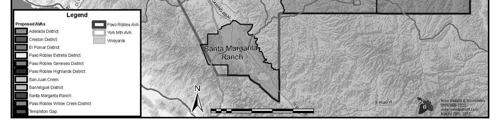
14 The following map shows the location of each of the 11 proposed viticultural areas within the larger Paso Robles viticultural area, as well as the location of the adjacent York Mountain viticultural area.
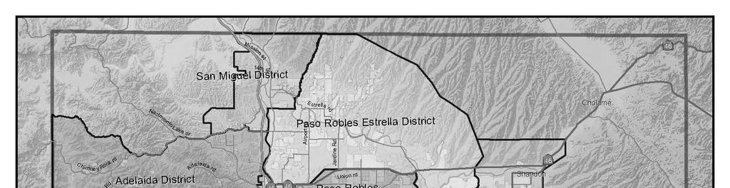
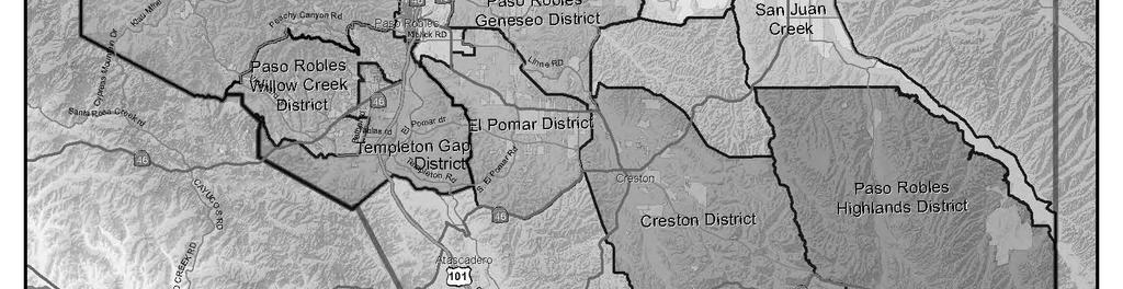
15 15
16 16 Adelaida District The proposed 53,000-acre Adelaida District viticultural area is located in the westernmost portion of the Paso Robles viticultural area and contains approximately 1,300 acres of vineyards. Name Evidence The proposed Adelaida District name is based on both historical and modern connections of the name Adelaida to the region in which the proposed viticultural area is located. The District modifier in the proposed name is a reference to the surrounding, larger Paso Robles viticultural area. The Adelaida or Adelaida District name historically has been used to geographically identify the area within the proposed Adelaida District viticultural area, and the Adelaida name was given to a local post office in In addition, the Adelaida Mining District, established in the late 1800s, is located in the southwest corner of the proposed viticultural area; the Adelaida School was located in the area and remained open until 1964; and the Adelaida Cemetery District, formed in 1940, serves the local rural population. (Although some early references use the spelling Adelaide, Adelaida is the currently accepted spelling.) The small town of Adelaida and the Adelaida Cemetery, both founded in 1891, are located within the proposed Adelaida District viticultural area, as shown on the USGS Adelaida quadrangle map. According to a 2001 San Luis Obispo 2 J. Fraser MacGillivray, History of Adelaida, California (1993), pages
17 County map produced by the Automobile Club of Southern California, Adelaida Road extends westward from the city of Paso Robles into the proposed viticultural area. The Adelaida name is also used in connection with the Adelaida Planning Area, established by San Luis Obispo County as part of the county s land use plan. TTB notes that the boundary of the Adelaida Planning Area encompasses a larger area that includes the proposed Adelaida District viticultural area within it, as shown on the Adelaida Rural Land Use Category Map. Boundary Evidence The northern portion of the proposed Adelaida District viticultural area boundary follows intermittent streams, straight lines between elevation points, and roads. The proposed boundary meanders west to east through mountainous terrain and then descends alongside San Marcos Creek toward the Salinas River. A portion of the northeastern boundary of the proposed Adelaida District viticultural area is shared with the southern boundary of the proposed San Miguel District viticultural area. The eastern portion of the proposed Adelaida District viticultural area boundary is based on the Salinas River and the western boundary of the city of Paso Robles. The proposed boundary separates the foothills and mountains of the proposed viticultural area from the near-flat, urbanized region to the east. The southern portion of the proposed Adelaida District viticultural area boundary follows roads, an intermittent stream, a range line, and a straight line between map points from the western boundary of the city of Paso Robles to a
18 rugged portion of the Santa Lucia Range. The southern boundary of the proposed viticultural area boundary is shared with a portion of the northern boundary of the established York Mountain viticultural area (27 CFR 9.80) and with the northern boundary of the proposed Paso Robles Willow Creek District viticultural area. The western portion of the proposed Adelaida District viticultural area boundary follows a range line, which runs through the Santa Lucia Range in the area of the Las Tablas Creek watershed. The western portion of the proposed Adelaida District viticultural area boundary is shared with a segment of the Paso Robles viticultural area s western boundary. Distinguishing Features The distinguishing features of the proposed Adelaida District viticultural area include a modest marine influence, average annual precipitation of 25 inches, a transitional Winkler Region II III climate, and high rolling slopes.
19 Climate The marine influence on the climate in the proposed Adelaida District viticultural area is more modest than in areas to the west outside the proposed viticultural area because the crest of the Santa Lucia Range largely shields the proposed viticultural area from the Pacific Ocean. This high-elevation range, located to the west and southwest of the proposed viticultural area, rarely allows marine air, heavy fog, or strong sea breezes into the proposed viticultural area. The range also inhibits the inland path of the prevailing wet, winter storms off the Pacific Ocean. Although the range blocks most of these storms, the proposed Adelaida District viticultural area still receives about 25 inches of rain annually. The marine air that moves southward through the Salinas Valley from Monterey Bay typically is limited to altitudes below 1,000 feet and cannot reach the high elevations of the proposed viticultural area. The result is clear, fog-free days and cool nights in the proposed Adelaida District viticultural area, which result in a longer growing season and later harvest date than regions with more marine influence. Although strong sea breezes usually do not reach the proposed Adelaida District viticultural area, light mountain and valley breezes result from warm air rising from lower elevations during the day and cool air sinking from the mountain peaks at night. These breezes help to moderate the daily temperature ranges within the proposed viticultural area and make high temperatures extremely rare. The annual heat summation of the proposed Adelaida District viticultural area
20 averages about 3,000 growing degree day (GDD) units, which is a high Region II or a low Region III in the Winkler climate classification system. Topography The proposed Adelaida District viticultural area is generally a mountainous area with steep ridges, frequently oriented in a northwest-to-southeast direction. The mountainous topography is primarily a result of the faulting and uplift of the South Coast Ranges, particularly the Santa Lucia Range. Elevations range from approximately 900 feet to approximately 2,200 feet, although most area vineyards are planted at elevations of 1,000 to 1,800 feet. At night, cool air drains off these high, steep ridges into the lower, flatter regions outside the proposed viticultural area. Because of the cool air drainage, frost is not a common occurrence within the proposed viticultural area. Soils The soils of the proposed Adelaida District viticultural area are hillside residual soils, which generally have shallow rooting depths and a relatively high water-holding capacity, but are also well-drained by the subsurface weathered bedrock. The primary parent material of the soils of the proposed viticultural area is the Monterey Formation, which is comprised of sedimentary shales, mudstones, and sandstones. Soil textures within the proposed Adelaida District viticultural area are predominantly silty clay loam and clay loam, with some gravelly units. The soils are generally moderately developed Mollisols where surface humus is abundant, Alfisols where more leaching to depth has occurred, and Vertisols where
21 pedogenic clay dominates the texture. The soils are slightly alkaline, with a surface horizon ph of between 7.4 and 8.4 and have low-to-moderate nutrient levels. The modest rooting depths, nutrient levels, and water-holding capacity of the soils promote a moderate amount of stress on grapevines, and low vineyard yields are common within the proposed Adelaida District viticultural area. Comparison to Adjacent Regions The following chart summarizes the distinguishing features of the proposed Adelaida District viticultural area and compares those features to those of the adjacent proposed viticultural areas. In addition, the proposed Adelaida District viticultural area is immediately adjacent to, and would share its southernmost boundary with a portion of, the York Mountain viticultural area s northern boundary. The York Mountain viticultural area is distinguishable from the proposed viticultural area because it contains lower elevations on the slopes of the Santa Lucia Range, has a cooler maritime Winkler Region I climate, and receives an average of 45 inches of annual rainfall. TTB notes that the region to the north of the proposed viticultural area is within the Paso Robles viticultural area, but it is not included in any of the viticultural areas proposed in this document. This area is distinguishable from the proposed Adelaida District viticultural area based on its generally lower elevations and flatter terrain. In addition, a large portion of this region is unavailable for commercial viticulture because it is part of the Camp Roberts Military Reservation. The area immediately to the west that is not within either
22 the Paso Robles viticultural area or the York Mountain viticultural area contains the rugged, mountainous terrain of the Santa Lucia Range. Comparison of Proposed Adelaida District Viticultural Area to Adjacent Proposed Viticultural Areas Distinguishing Features Winkler Region Adelaida District Transitional Region II III To the North: San Miguel District Warm Region III To the East: Paso Robles Estrella District Moderate Region III To the South: Paso Robles Willow Creek District Region II Maritime Climate* Precipitation 25 inches/year 11.4 inches/year inches/year inches/year Topography Santa Lucia Range high mountain slopes grading to base of foothills; elevation approximately 900-2,200 feet (most vineyards at 1,100 1,800 feet). Santa Lucia Range footslope into Salinas and Estrella River valleys; alluvial fans and welldefined river terraces; elevation 580-1,600 feet (most vineyards at feet). Rolling plains of Estrella River valley and terraces; elevation approximately 745 1,819 feet (most vineyards at 750 1,000 feet). Mountain slopes of Santa Lucia Range to the west of the Salinas River, centered on the Willow Creek tributary to Paso Robles Creek; elevation 960 1,900 (most vineyards at 1,000 1,300 feet). Soils Shallow, welldrained, residual soils with silty and clay loam textures; moderately alkaline. Deep alluvial soils, with clay, sandy, and gravelly loam textures. Deep to moderate depth alluvial terrace soils, with sandy to coarse and clay loam textures; slightly acidic, but more alkaline at depth. Mostly shallow calcareous soils of residual (bedrock) origin with shaly clays, clay loams, and rocky loams, with some units gravelly and with patches of alluvial soil along streams; alkaline at depth. *Maritime climate indicated on scale from 1 (most maritime) to 8 (more continental).
23 Creston District The proposed 47,000-acre Creston District viticultural area is located in the south-central portion of the Paso Robles viticultural area and contains approximately 1,400 acres of vineyards. Name Evidence The Creston District name is based on its historical and modern association with the region. The District modifier indicates that the proposed Creston District viticultural area is a sub-region of the larger Paso Robles viticultural area. Creston and Creston District have been used historically to identify the small rural community, school district, community services district, electoral precinct, and groundwater planning area of San Luis Obispo County contained within the proposed Creston District viticultural area. The town of Creston, originally named Huerhuero after a land grant in the area, was founded in The town name eventually was changed to Creston in honor of a founding father of the area, C.J. Cressey. 3 According to an 1890 San Luis Obispo county map based on government and county surveys, the Creston name also identifies the larger region within the proposed Creston District viticultural area. A 1913 San Luis Obispo County Surveyor map shows Creston voting precinct. In addition, historical references to the Creston District are contained in the History of San Luis Obispo County by Morrison and Haydon, which was published in 1917 and reprinted in 2002 as the 3 Linnea Waltz, And just where is Huer Huero? San Luis Obispo County Telegram Tribune, October 5, 1974, page 8.
24 Pioneers of San Luis Obispo County and Environs, and which includes, for example, the biography of John D. Biggs, who * * * engaged in farming in the Creston district. The first school district named Creston District was formed in 1885, and, in 1923, several rural school districts merged to form the Creston Elementary School District, according to the History of Creston Elementary School (see Today, Creston continues to be a well-known community and region of San Luis Obispo County. The USGS Creston Quadrangle map identifies the small town of Creston within the historical Huerhuero Land Grant, and a 2001 map published by the Automobile Club of Southern California (California Regional Series, San Luis Obispo County map) identifies the small town of Creston to the southeast of the city of Paso Robles. Multiple local businesses located in the proposed Creston District viticultural area use Creston in their names, including Creston Valley Meats, Creston Valley Quilt Ranch, Creston Farms, and the Creston Volunteer Firefighters (which are no longer active, but which served an area that closely approximates the boundaries of the proposed Creston District viticultural area). Boundary Evidence According to the proposed boundary description and USGS maps, the northern portion of the proposed Creston District viticultural area boundary uses a road and straight lines to connect map points across a series of foothills and rugged mountain terrain. The proposed boundary in this area separates the rugged terrain of the proposed Creston District viticultural area from the rolling
25 hills and lower elevations in the region to the north, which is within the larger Paso Robles viticultural area but not within any of the other viticultural areas proposed in this document. The eastern portion of the proposed Creston District viticultural area boundary includes portions of Indian Creek, roads, and a straight line. TTB notes that the proposed Creston District viticultural area shares the eastern portion of its boundary with most of the western portion of the proposed Paso Robles Highlands District viticultural area boundary. The southern portion of the proposed boundary shares part of the southern portion of the Paso Robles viticultural area boundary, which is also concurrent with part of the northern Los Padres National Forest boundary. The land to the south of the proposed Creston District viticultural area is increasingly steep and rugged, especially in the Los Padres National Forest, as the terrain ascends into the La Panza Range. The western portion of the proposed boundary follows the Huerhuero Land Grant line, other lines that closely follow the land grant, and the Middle Branch of the Huerhuero Creek. The terrain is more mountainous to the southwest of the proposed Creston District viticultural area; to the northwest, the terrain tends to be more gentle and flat. The proposed El Pomar District and Paso Robles Geneseo District viticultural areas share sections of the northwest portion of the proposed Creston District viticultural area boundary.
26 Distinguishing Features The distinguishing features of the proposed Creston District viticultural area include a modest marine influence, an annual average of 11.5 inches of precipitation, and a Winkler Region III climate. Old river terraces and mountain foothills dominate the landscape, and elevations vary between approximately 1,000 to 2,000 feet, increasing from north to south. Climate The climate of the proposed Creston District viticultural area is influenced by its location east of the Templeton Gap and Santa Lucia Coast Range and south of the La Panza Range. Sea breezes that blow inland off the Pacific Ocean and through the Templeton Gap passes in the Santa Lucia Range reach the proposed Creston District viticultural area during the day, and cold air draining off the La Panza Range travels down Huerhuero Creek and into the proposed viticultural area in the evenings. In addition, cooling marine air from Morro Bay to the south occasionally penetrates into the proposed Creston District viticultural area. The moderating effect of the cold air drainage and the sea breezes places the temperature of the proposed Creston District viticultural area into the low-to-moderate Region III category under the Winkler GDD system. The proposed Creston District viticultural area also is located in the rain shadows of the La Panza Range and the Santa Lucia Range. As a result, precipitation is low within the proposed viticultural area, averaging 11.5 inches annually. Although the annual precipitation amounts are low, there is abundant
27 groundwater and near-surface water along Huerhuero Creek for irrigating vineyards.
28 Topography The landscape of the proposed Creston District viticultural area is an intermediate-to-high elevation area of old river terraces and mountain foothills at the base of the La Panza Range. Huerhuero Creek bisects the proposed viticultural area as it travels northwestward from the proposed viticultural area through other parts of the Paso Robles viticultural area until it eventually joins the Salinas River. The East Branch and Middle Branch of the Huerhuero Creek flow through foothills and terraces, forming narrow valleys with loamy soils and nearsurface water and springs. These creeks also serve as a conduit for cold air draining at night from the higher slopes of the La Panza Range into the proposed viticultural area. Elevations of the proposed Creston District viticultural area range from approximately 1,000 feet along Huerhuero Creek to approximately 2,000 feet along the southern portion of the proposed boundary. To the south of the proposed Creston District viticultural area, the rugged mountain terrain increases to 3,622 feet in elevation at the pinnacle of Black Mountain, according to USGS maps. Vineyards in the proposed Creston District viticultural area are mostly planted at elevations of 1,000 feet to 1,300 feet, with a few vineyards located on higher bedrock hills up to 1,800 feet. Many vineyards are located on west and southwest facing slopes to take advantage of the summer marine breezes that travel through the Templeton Gap area and into the proposed Creston District viticultural area.
29 Soils The parent materials of the soils of the proposed Creston District viticultural area are granitic rocks, non-marine sandstones, marine Monterey shales and sandstones, and the Paso Robles Formation. Over time, Huerhuero Creek has transported mixed sediments of granitic boulders, cobbles, finer gravels and sands, shales, sandstone fragments, and silts from the La Panza Range into the proposed viticultural area. The granitics are high in silica, and the Monterey Formation shales and fine sandstones are high in calcium carbonate in some places. As the rock fragments weather and are dissolved in water, the resulting materials cause cementation of the sediments and soils, decreasing the soil s water-holding capacity and rooting depths for plants, including grapevines. The true loams to sandy loams in the area have a higher percentage of granitic coarse sands and gravels, allowing for deeper rooting depths and better drainage. Most of the soils are slightly acidic at the surface and more alkaline at depths below the surface. Soil textures in the proposed Creston District viticultural area are predominantly fine sandy loams to sandy loams along the creeks, to gravelly sandy loams to clay loams on the terraces. The most common soil order in the area is the moderately developed grassland Mollisols, followed by younger, poorly developed Inceptisols and Entisols along the creeks, the occasional older Alfisols on higher hillsides, and heavy clay Vertisols in some low-lying spots. Area soils are considered moderately fertile.
30 Comparison to Adjacent Regions The following chart summarizes the distinguishing features of the proposed Creston District viticultural area and compares those features to those of the adjacent proposed viticultural areas. The regions to the north and southwest of the proposed Creston District viticultural area are within the Paso Robles viticultural area but are not included in any of the viticultural areas proposed in this document. The area to the north is distinguishable from the proposed Creston District viticultural area due to its highly eroded terrain, shallow soils, and steep slopes, which contribute to slope instability and a high erosion hazard. The region to the southwest is more mountainous and rugged; further west is the city of Atascadero. The area to the south is located outside of the Paso Robles viticultural area and contains rugged terrain with higher elevations than those of the proposed Creston District viticultural area. Comparison of Proposed Creston District Viticultural Area to Adjacent Proposed Viticultural Areas Distinguishing Features Winkler Region Maritime Climate* Creston District Low-Moderate Region III To the East: Paso Robles Highlands District Low Region IV To the Northwest: El Pomar District Moderate Region II To the Northwest: Paso Robles Geneseo District Transitional Regions III IV Precipitation 11.5 inches/year 12 inches/year 15 inches/year inches/year Topography Old erosional plateau at base of La Panza Range; alluvial terraces and fans of Huerhuero Creek; elevation approximately 1,000 2,000 feet (most vineyards at 1,030 1,300 feet). Transitional area from valley floor to mountain slope; elevation 1,160 2,086 feet (most vineyards at 1,200 1,600 feet). Upfaulted hills High, older terraces, fans, and hills; elevation 740-1,600 feet (most vineyards at feet). through old river terraces; terraces; elevation 740 1,300 feet (most vineyards at 880 1,200 feet).
31 Soils Terrace alluvial and some residual soils, with fine sandy to gravelly and clay loam textures; slightly acidic at surface, more alkaline at depth. Deep alluvial soils, with sandy to coarse and clay loam textures, mostly alkaline at depth. Terrace alluvial soils, with sandy, clay, and gravelly loam textures; primarily alkaline. Well-developed moderate depth residual and alluvial soils, with silty clays and silty clay loam textures; ph varied, but mostly acidic. *Maritime climate indicated on scale from 1 (most maritime) to 8 (more continental). El Pomar District The proposed 21,300-acre El Pomar District viticultural area is located in the central portion of the Paso Robles viticultural area and includes 2,000 acres of vineyards. Name Evidence The El Pomar District name is based on its historical and modern connection with the region. The name originally dates back to the early 1900s, and it continues to be widely used by local residents, realtors, wineries, grape growers, and others. The names El Pomar and El Pomar District, derived from the Spanish word for orchard, refer to an unincorporated agricultural area within the larger Paso Robles viticultural area. The El Pomar District is generally defined as [a]n area between Templeton and Creston noted for its fruit and almond growing * * * 4 TTB notes that the proposed El Pomar District viticultural area is located between the towns of Templeton and Creston. 4 Mark P. Hall-Patton, Memories of the Land, Placenames of San Luis Obispo County (San Luis Obispo: EZ Nature Books, 1994), page 52.
32 An undated local history book, The End of the Line, Recollections and a History of Templeton, compiled by Al Willhoit, dedicates a full chapter to El Pomar and explains that the area gained its name recognition as El Pomar in The Willhoit book includes family histories by former and current residents of the area, many of whom refer to it as the El Pomar District or the El Pomar area. According to a 1926 newspaper article, the El Pomar District was first subdivided into separate lots in 1886, and early settlers planted orchards in the area shortly thereafter. 5 El Pomar Drive and South El Pomar Road run through the approximate middle of the proposed El Pomar District viticultural area, and a San Luis Obispo County Web site contains a map (included with the petition) that identifies El Pomar Drive and South El Pomar Road in the proposed El Pomar District viticultural area. The El Pomar Area is also a recognized region on the 1986 voting precinct map for San Luis Obispo County and is located in the same general area as the proposed El Pomar District viticultural area. The petition also notes that two of the vineyards within the proposed viticultural area are named El Pomar Vineyards and Pomar Junction Vineyards. Boundary Evidence The proposed boundary of the viticultural area corresponds with the historical references to the El Pomar area. According to the Willhoit book, the Santa Ysabel Land Grant and the subdivision of Eureka Rancho, both of which are generally located within the proposed viticultural area, have historically been 5 El Pomar: Where Contented Ranchers Have Built Happy Homes Almonds Lead Grain, Cattle, And Vineyards, Paso Robles Press, May 30, 1926, page 7.
33 associated with the proposed El Pomar District viticultural area. As noted in the Willhoit book, [t]he area to become the El Pomar District lies within the Santa Ysabel, part of the tract known as the Eureka Rancho, being a portion of the subdivisions of Rancho La Asuncion. An undated San Luis Obispo County map submitted with the petition shows that the Santa Ysabel Land Grant boundary generally corresponds with the proposed El Pomar District viticultural area boundary. In addition, in 1999, Milene Radford, a longtime San Luis Obispo County resident, drew a map of the El Pomar District that includes the entire proposed El Pomar District viticultural area for the Pioneer Pages, an annual publication produced by the El Paso de Robles Area Pioneer Museum. The eastern portion of the proposed boundary follows a series of roads and hills and separates the proposed El Pomar District viticultural area from the higher elevations to the east. A portion of the eastern boundary is shared with a portion of the western boundary of the proposed Creston District viticultural area. The southern portion of the proposed El Pomar District viticultural area boundary uses a series of roads in the foothills of the La Panza Range that follow approximately the exposed granitic rocks and growths of dense chaparral and forest vegetation in the area. The region to the south of the proposed viticultural area is within the Paso Robles viticultural area but not within any of the other viticultural areas proposed in this document. The western portion of the proposed El Pomar District viticultural area boundary follows a series of peaks and roads that approximate the Rinconada Fault and define the western geological and topographical boundary of the area.
34 In addition, a line of hills that rise 400 to 500 feet above the fault line visually defines the western portion of the proposed El Pomar District boundary. A portion of the western boundary is shared with the eastern boundary of the proposed Templeton Gap District viticultural area. At TTB s request, the proposed El Pomar District viticultural area s northwestern corner was adjusted westward in order to follow a road and other more easily located features rather than the now hard-to-locate former city limit line of Paso Robles. The northern portion of the proposed El Pomar District viticultural area boundary then extends to the ridgeline of the Huerhuero Hills area, an uplifted area along the La Panza Huerhuero Fault. This ridgeline, which is located along the northeastern portion of the proposed boundary, serves as a partial barrier to marine air flowing eastward from the Pacific Ocean. To the north of the proposed boundary is the proposed Paso Robles Geneseo District viticultural area, and the urbanized area of the city of Paso Robles is to the northwest. Distinguishing Features The distinguishing features of the proposed El Pomar District viticultural area include a pronounced marine influence, an annual average of 15 inches of precipitation, and a moderate Winkler Region II climate. High, older terraces, alluvial fans, and hills dominate the landscape, and elevations vary between 740 and 1,600 feet.
[Billing Code: P] [Docket No. TTB ; T.D. TTB 148; Re: Notice No. 162] AGENCY: Alcohol and Tobacco Tax and Trade Bureau, Treasury.
![[Billing Code: P] [Docket No. TTB ; T.D. TTB 148; Re: Notice No. 162] AGENCY: Alcohol and Tobacco Tax and Trade Bureau, Treasury.](/thumbs/81/83414830.jpg "[Billing Code: P] [Docket No. TTB ; T.D. TTB 148; Re: Notice No. 162] AGENCY: Alcohol and Tobacco Tax and Trade Bureau, Treasury.") This document is scheduled to be published in the Federal Register on 12/07/2017 and available online at https://federalregister.gov/d/2017-26414, and on FDsys.gov [Billing Code: 4810 31 P] DEPARTMENT
This document is scheduled to be published in the Federal Register on 12/07/2017 and available online at https://federalregister.gov/d/2017-26414, and on FDsys.gov [Billing Code: 4810 31 P] DEPARTMENT
96 of 100 DOCUMENTS FEDERAL REGISTER. 27 CFR Part 9. Napa Valley Viticultural Area. [TD ATF-79; Re: Notice No. 337] 46 FR 9061.
![96 of 100 DOCUMENTS FEDERAL REGISTER. 27 CFR Part 9. Napa Valley Viticultural Area. [TD ATF-79; Re: Notice No. 337] 46 FR 9061.](/thumbs/95/123569252.jpg "96 of 100 DOCUMENTS FEDERAL REGISTER. 27 CFR Part 9. Napa Valley Viticultural Area. [TD ATF-79; Re: Notice No. 337] 46 FR 9061.") Page 1 96 of 100 DOCUMENTS FEDERAL REGISTER 27 CFR Part 9 Napa Valley Viticultural Area [TD ATF-79; Re: Notice No. 337] January 28, 1981 ACTION: Final rule; Treasury decision. SUMMARY: This rule establishes
Page 1 96 of 100 DOCUMENTS FEDERAL REGISTER 27 CFR Part 9 Napa Valley Viticultural Area [TD ATF-79; Re: Notice No. 337] January 28, 1981 ACTION: Final rule; Treasury decision. SUMMARY: This rule establishes
[Billing Code: P] [Docket No. TTB ; T.D. TTB 151; Ref: Notice No. 166] Establishment of the Dahlonega Plateau Viticultural Area
![[Billing Code: P] [Docket No. TTB ; T.D. TTB 151; Ref: Notice No. 166] Establishment of the Dahlonega Plateau Viticultural Area](/thumbs/81/83414833.jpg "[Billing Code: P] [Docket No. TTB ; T.D. TTB 151; Ref: Notice No. 166] Establishment of the Dahlonega Plateau Viticultural Area") This document is scheduled to be published in the Federal Register on 06/29/2018 and available online at https://federalregister.gov/d/2018-14035, and on FDsys.gov [Billing Code: 4810 31 P] DEPARTMENT
This document is scheduled to be published in the Federal Register on 06/29/2018 and available online at https://federalregister.gov/d/2018-14035, and on FDsys.gov [Billing Code: 4810 31 P] DEPARTMENT
1 of 100 DOCUMENTS 48 FR FEDERAL REGISTER. 27 CFR Part 9. Arroyo Seco Viticultural Area. [T.D. ATF-131; Reference Notice No. 431] April 15, 1983
![1 of 100 DOCUMENTS 48 FR FEDERAL REGISTER. 27 CFR Part 9. Arroyo Seco Viticultural Area. [T.D. ATF-131; Reference Notice No. 431] April 15, 1983](/thumbs/78/77338848.jpg "1 of 100 DOCUMENTS 48 FR FEDERAL REGISTER. 27 CFR Part 9. Arroyo Seco Viticultural Area. [T.D. ATF-131; Reference Notice No. 431] April 15, 1983") Page 1 1 of 100 DOCUMENTS 48 FR 16245 FEDERAL REGISTER 27 CFR Part 9 Arroyo Seco Viticultural Area [T.D. ATF-131; Reference Notice No. 431] April 15, 1983 ACTION: Final rule, Treasury decision. SUMMARY:
Page 1 1 of 100 DOCUMENTS 48 FR 16245 FEDERAL REGISTER 27 CFR Part 9 Arroyo Seco Viticultural Area [T.D. ATF-131; Reference Notice No. 431] April 15, 1983 ACTION: Final rule, Treasury decision. SUMMARY:
7 of 100 DOCUMENTS FEDERAL REGISTER. 27 CFR Part 9. Santa Lucia Highlands, CA 91F016P. [T.D. ATF-321:RE:Notice No. 722] RIN 1512-AA07 57 FR 20762
![7 of 100 DOCUMENTS FEDERAL REGISTER. 27 CFR Part 9. Santa Lucia Highlands, CA 91F016P. [T.D. ATF-321:RE:Notice No. 722] RIN 1512-AA07 57 FR 20762](/thumbs/74/70071585.jpg "7 of 100 DOCUMENTS FEDERAL REGISTER. 27 CFR Part 9. Santa Lucia Highlands, CA 91F016P. [T.D. ATF-321:RE:Notice No. 722] RIN 1512-AA07 57 FR 20762") Page 1 7 of 100 DOCUMENTS FEDERAL REGISTER 27 CFR Part 9 Santa Lucia Highlands, CA 91F016P [T.D. ATF-321:RE:Notice No. 722] RIN 1512-AA07 57 FR 20762 May 15, 1992 ACTION: Final rule, Treasury decision.
Page 1 7 of 100 DOCUMENTS FEDERAL REGISTER 27 CFR Part 9 Santa Lucia Highlands, CA 91F016P [T.D. ATF-321:RE:Notice No. 722] RIN 1512-AA07 57 FR 20762 May 15, 1992 ACTION: Final rule, Treasury decision.
9 of 100 DOCUMENTS FEDERAL REGISTER. 27 CFR Part 9. Establishment of Mt. Veeder, CA Viticultural Area (88F-20P) [T.D. ATF-295 Re; Notice No.
 [T.D. ATF-295 Re; Notice No.") Page 1 9 of 100 DOCUMENTS FEDERAL REGISTER 27 CFR Part 9 Establishment of Mt. Veeder, CA Viticultural Area (88F-20P) [T.D. ATF-295 Re; Notice No. 685] RIN 1512-AA07 55 FR 5842 February 20, 1990 ACTION:
Page 1 9 of 100 DOCUMENTS FEDERAL REGISTER 27 CFR Part 9 Establishment of Mt. Veeder, CA Viticultural Area (88F-20P) [T.D. ATF-295 Re; Notice No. 685] RIN 1512-AA07 55 FR 5842 February 20, 1990 ACTION:
LAKE ONTARIO BEAMSVILLE BENCH VINEMOUNT RIDGE STATISTICS
 APPELLATION MAP Appellation Overview Diverse terroir, vine friendly micro climates, remarkably complex wines The Niagara Peninsula has the largest planted area of all viticulture areas in Canada. Situated
Monterey County Ranch Johnson Canyon Road Gonzales, CA Acres
 Monterey County Ranch 31701 Johnson Canyon Road Gonzales, CA 523.15 Acres Introduction Located in California s Central Coast in the heart of the Salinas Valley lies the Gallo family s Monterey County Ranch.
Billing Code: P. [Docket No. TTB ; T.D. TTB 149; Re: Notice No. 163]
![Billing Code: P. [Docket No. TTB ; T.D. TTB 149; Re: Notice No. 163]](/thumbs/95/125372035.jpg "Billing Code: P. [Docket No. TTB ; T.D. TTB 149; Re: Notice No. 163]") This document is scheduled to be published in the Federal Register on 12/07/2017 and available online at https://federalregister.gov/d/2017-26410, and on FDsys.gov Billing Code: 4810 31 P DEPARTMENT OF
This document is scheduled to be published in the Federal Register on 12/07/2017 and available online at https://federalregister.gov/d/2017-26410, and on FDsys.gov Billing Code: 4810 31 P DEPARTMENT OF
Cool Climate Deep Dive
 Cool Climate Deep Dive What does cool climate mean? Let s start at the beginning: (Still THE text book for UC Davis Viticulture 101) What does cool climate mean? Climate directly influences grape quality:
Mendocino County Conjunctive Labeling Forum
 Mendocino County Conjunctive Labeling Forum Federal & State Wine Labeling Regulations November 29, 2018 Presented by: John Trinidad Concurrent Federal & State Power Federal Power State Power Federal: Enumerated
46 of 100 DOCUMENTS FEDERAL REGISTER. 27 CFR Part 9. Lodi Viticultural Area. [T. D. ATF-223; Re: Notice No. 567] 51 FR 5323.
![46 of 100 DOCUMENTS FEDERAL REGISTER. 27 CFR Part 9. Lodi Viticultural Area. [T. D. ATF-223; Re: Notice No. 567] 51 FR 5323.](/thumbs/87/95695131.jpg "46 of 100 DOCUMENTS FEDERAL REGISTER. 27 CFR Part 9. Lodi Viticultural Area. [T. D. ATF-223; Re: Notice No. 567] 51 FR 5323.") Page 1 46 of 100 DOCUMENTS FEDERAL REGISTER 27 CFR Part 9 Lodi Viticultural Area [T. D. ATF-223; Re: Notice No. 567] 51 FR 5323 February 13, 1986 ACTION: Treasury decision, final rule. SUMMARY: The Bureau
Page 1 46 of 100 DOCUMENTS FEDERAL REGISTER 27 CFR Part 9 Lodi Viticultural Area [T. D. ATF-223; Re: Notice No. 567] 51 FR 5323 February 13, 1986 ACTION: Treasury decision, final rule. SUMMARY: The Bureau
[Billing Code: U] [Docket No. TTB ; T.D. TTB 112; Ref: Notice No. 127] Amendment to the Standards of Identity for Distilled Spirits
![[Billing Code: U] [Docket No. TTB ; T.D. TTB 112; Ref: Notice No. 127] Amendment to the Standards of Identity for Distilled Spirits](/thumbs/77/76671202.jpg "[Billing Code: U] [Docket No. TTB ; T.D. TTB 112; Ref: Notice No. 127] Amendment to the Standards of Identity for Distilled Spirits") This document is scheduled to be published in the Federal Register on 02/25/2013 and available online at http://federalregister.gov/a/2013-04242, and on FDsys.gov [Billing Code: 4810 31 U] DEPARTMENT OF
This document is scheduled to be published in the Federal Register on 02/25/2013 and available online at http://federalregister.gov/a/2013-04242, and on FDsys.gov [Billing Code: 4810 31 U] DEPARTMENT OF
Washington State Wine 101
 Washington State Wine 101 Washington 2 nd Largest Producer in US Washington State produces: Premium wines of superior quality Range of varieties Distinctive character Unique balance of Old World and New
5/9/2017. Latitude. Rías, Benches, Slopes, and Scarps. Physical Geography in the Vineyard
 Rías, Benches, Slopes, and Scarps Physical Geography in the Vineyard Latitude The geographic coordinate that specifies north/south position The angular distance of a place north or south of the equator
L I N D E M A N N. Young Almonds Excellent Production Potential Madera County Acres P R O P E R T I E S I N C.
 L I N D E M A N N Young Almonds Excellent Production Potential Madera County 19.11+- Acres P R O P E R T I E S I N C. 3734 W. Spruce Ave Fresno, CA 93711 TEL-559-479-1658 FAX-559-827-4077 Young Almonds
DRAFT SECTION 4(F) EVALUATION FAIRVIEW CEMETERY
 EVALUATION FAIRVIEW CEMETERY") DRAFT SECTION 4(F) EVALUATION I. DESCRIPTION OF SECTION 4(F) RESOURCE The Section 4(f) resource that could be affected by the proposed action is Fairview Cemetery. The proposed action would require the
DRAFT SECTION 4(F) EVALUATION I. DESCRIPTION OF SECTION 4(F) RESOURCE The Section 4(f) resource that could be affected by the proposed action is Fairview Cemetery. The proposed action would require the
Vineyard Site Evaluation For: Beringer
 For: Location: 32720 SW Bell Rd, Sherwood OR 97140 T3S R2W Sec 11 Total Property Acreage: TL200 (39.7 acres), TL300 (19.84 acres), TL301 (59.99 acres) Gross Plantable Vineyard Acres (approximate): 90.0
APPENDIX C - NRCS PRIME FARMLAND REPORT
 APPENDIX C - NRCS PRIME FARMLAND REPORT June 2007 Page 51 Parks, Trails, and Open Space Plan Page 52 Payson City- East Side Comprehensive Plan FARMLAND CLASSIFICATION RATING FOR UTAH COUNTY, UTAH - CENTRAL
 72C 155F 350B 350C 542A SOILS IN AREA OF INTEREST Doughty Loam; 4 to 8 percent slopes Anceney Cobbly Loam; 15 to 60 percent slopes Blackmore Silt Loam; 0 to 4 percent slopes Blackmore Silt Loam; 4 to 8
location location, location, Multi-vineyard Pinot Noir with a distinct sense of place
 location, location, location Multi-vineyard Pinot Noir with a distinct sense of place from hand-picked vineyards in California. From gravelly, well-draining sites in Monterey, elevated vineyards on steep
NZ GEOGRAPHICAL INDICATION (GI)
") NZ GEOGRAPHICAL INDICATION (GI) EXAMINATION CHECKSHEET Application information (reg 7) and formalities Box Reference Number 1 GI Number: 1021 GI Name: MATAKANA 2 New Zealand GI correctly selected (cf foreign)
NZ GEOGRAPHICAL INDICATION (GI) EXAMINATION CHECKSHEET Application information (reg 7) and formalities Box Reference Number 1 GI Number: 1021 GI Name: MATAKANA 2 New Zealand GI correctly selected (cf foreign)
Federal Register / Vol. 76, No. 208 / Thursday, October 27, 2011 / Rules and Regulations
 66629 Pinot Meunier (Meunier) Piquepoul blanc (Picpoul) Prairie Star Princess Refosco (Mondeuse) Reliance Rkatsiteli (Rkatziteli) Rondinella Sabrevois Sagrantino St. Pepin St. Vincent Sauvignon gris Seyval
NZ GEOGRAPHICAL INDICATION (GI)
") NZ GEOGRAPHICAL INDICATION (GI) EXAMINATION CHECKSHEET Application information (reg 7) and formalities Box Reference Number 1 GI Number: 1015 GI Name: WAIHEKE ISLAND 2 New Zealand GI correctly selected
NZ GEOGRAPHICAL INDICATION (GI) EXAMINATION CHECKSHEET Application information (reg 7) and formalities Box Reference Number 1 GI Number: 1015 GI Name: WAIHEKE ISLAND 2 New Zealand GI correctly selected
AGENCY: Grain Inspection, Packers and Stockyards Administration, USDA.
 This document is scheduled to be published in the Federal Register on 05/15/2017 and available online at https://federalregister.gov/d/2017-09721, and on FDsys.gov [BILLING CODE 3410-KD-U] DEPARTMENT OF
primarily serving the Central Coast hospitality market in San Luis Obispo County
 CASS WINERY PRESENTS primarily serving the Central Coast hospitality market in San Luis Obispo County Cass Winery s Mobile Wine Workshop offers a broad range of wine programs focusing on education, exploration
PROPERTY REPORT PRICE: $1,200, APN s: , & CONTACT: Donn Bree
 PROPERTY REPORT ADDRESS: 14110 Ridge Road, Sutter Creek, CA 95685 DESCRIPTION: This stunning 200.39 acres is located in the heart of Amador County s wine country. This beautiful property is situated in
49 of 100 DOCUMENTS FEDERAL REGISTER. 27 CFR Part 9. Establishment of Central Coast Viticultural Area. [T.D. ATF-216; Re: Notice No.
 Page 1 49 of 100 DOCUMENTS FEDERAL REGISTER 27 CFR Part 9 Establishment of Central Coast Viticultural Area [T.D. ATF-216; Re: Notice No. 532] 50 FR 43128 October 24, 1985 ACTION: Final rule, Treasury decision.
Erosion Hazard (Off-Road, Off-Trail) Angelina County, Texas (Upland Island Erosion Hazard (Off-Road, Off-Trail))
 Angelina County, Texas (Upland Island Erosion Hazard (Off-Road, Off-Trail))") Cypress Creek Erosion Hazard (Off-Road, Off-Trail) Angelina County, Texas () 31 7' 50'' 31 4' 50'' 3439500 3440400 3441300 3442200 3443100 3444000 3444900 94 24' 48'' 94 24' 51'' 365700 Graham Creek 365700
Cypress Creek Erosion Hazard (Off-Road, Off-Trail) Angelina County, Texas () 31 7' 50'' 31 4' 50'' 3439500 3440400 3441300 3442200 3443100 3444000 3444900 94 24' 48'' 94 24' 51'' 365700 Graham Creek 365700
Erosion Hazard (Road, Trail) Angelina County, Texas (Upland Island Erosion Hazard (Road, Trail)) Web Soil Survey National Cooperative Soil Survey
 Angelina County, Texas (Upland Island Erosion Hazard (Road, Trail)) Web Soil Survey National Cooperative Soil Survey") Cypress Creek Erosion Hazard (Road, Trail) Angelina County, Texas () 31 7' 50'' 31 4' 50'' 3439500 3440400 3441300 3442200 3443100 3444000 3444900 94 24' 48'' 94 24' 51'' 365700 Graham Creek 365700 366600
Cypress Creek Erosion Hazard (Road, Trail) Angelina County, Texas () 31 7' 50'' 31 4' 50'' 3439500 3440400 3441300 3442200 3443100 3444000 3444900 94 24' 48'' 94 24' 51'' 365700 Graham Creek 365700 366600
Winery Property in Niagara-on-the-Lake Vineyard/Production/Retail
 VIEW ONLINE Winery Property in Niagara-on-the-Lake Vineyard/Production/Retail Estate sale DeMoura Winery Way Property 545 Niagara Stone Road, Niagara-on-the-Lake, ON Asking Price: $1,700,000 > Gateway
PROPERTY REPORT. ADDRESS: Ridge Road, Sutter Creek, CA 95685
 PROPERTY REPORT ADDRESS: 14110 Ridge Road, Sutter Creek, CA 95685 DESCRIPTION: This stunning 347 +/- ACRE Vineyard and Winery is located in the heart of Amador County s wine country. This beautiful property
TABLE OF CONTENTS. Page. Page
 TABLE OF CONTENTS Chapter 1 INTRODUCTION... 1-1 Background... 1-1 Planning Benefits... 1-1 Comprehensive Planning Law... 1-4 County Partnership... 1-5 Advisory Committee and Staff Structure... 1-5 Plan
Suitability for Haul Roads (MI) Macomb County, Michigan, and Oakland County, Michigan (River Bends Park, West Side, Shelby Twp.)
 Macomb County, Michigan, and Oakland County, Michigan (River Bends Park, West Side, Shelby Twp.)") Suitability for Haul Roads (MI) Macomb, and Oakland () MAP LEGEND Area of Interest () Soils Soil Ratings Area of Interest () Soil Map Units Poorly suited Moderately suited Well suited Political Features
Suitability for Haul Roads (MI) Macomb, and Oakland () MAP LEGEND Area of Interest () Soils Soil Ratings Area of Interest () Soil Map Units Poorly suited Moderately suited Well suited Political Features
Appendix II Dubois Badlands and Whiskey Mountain WSAs. Information and Recommendations
 Appendix II - 11 Dubois Badlands and Whiskey Mountain WSAs Information and Recommendations Map 11 Existing Situation and Recommendation Dubois Badlands and Whiskey Mountain WSAs Both Recommended for Release
7365 Adelaida Road, Paso Robles, California
 7365 Adelaida Road, Paso Robles, California R E M A X P A R K S I D E R E A L E S T A T E Specializing in Ranches, Vineyard & Lake Properties in Northern San Luis Obispo County since 1988 Visit: www.jimirving.com
COLORADO REVISED STATUTES, TITLE 35, AGRICULTURE
 COLORADO REVISED STATUTES, TITLE 35, AGRICULTURE ARTICLE 29.5: COLORADO WINE INDUSTRY DEVELOPMENT ACT Section 35-29.5-101. Short title. 35-29.5-101.5. Legislative declaration. 35-29.5-102. Definitions.
Healthy Soils for a Sustainable Viticulture John Reganold
 Healthy Soils for a Sustainable Viticulture John Reganold Department of Crop & Soil Sciences Pullman, W Sustainable Viticulture Economically viable Environmentally sound Socially responsible QuickTime
Reputation Tapping: Examining Consumer Response to Wine Appellation Information
 Reputation Tapping: Examining Consumer Response to Wine Appellation Information Brad Rickard, Assistant Professor Charles H. Dyson School of Applied Economics and Management Cornell University Presented
U.S. Department of Agriculture (USDA) Organic Labeling
 Organic Labeling") U.S. Department of Agriculture (USDA) Organic Labeling Presented by Shannon Nally 2009 TTB Expo Presentation Overview National Organic Program (NOP) History and Regulations abridged versions Alcohol beverages:
U.S. Department of Agriculture (USDA) Organic Labeling Presented by Shannon Nally 2009 TTB Expo Presentation Overview National Organic Program (NOP) History and Regulations abridged versions Alcohol beverages:
PROPERTY REPORT. ADDRESS: Ridge Road, Sutter Creek, CA 95685
 PROPERTY REPORT ADDRESS: 14110 Ridge Road, Sutter Creek, CA 95685 DESCRIPTION: This stunning 146.97-ACRE Vineyard and Winery is located in the heart of Amador County s wine country. This beautiful property
Utah. White Rock Range Wilderness Study Area Site-Specific Monitoring Guide
 Utah White Rock Range Wilderness Study Area Site-Specific Monitoring Guide 0 General Information WildSNAP Monitoring Peter Woodruff, American Conservation Experience Coordinator Phone (801) 989-7069 Main
our chilean vineyards Los Andes Valparaiso SANTIAGO San Antonio locations Santa Cruz Concepción
 our chilean vineyards Valparaiso San Antonio SANTIAGO locations Santa Cruz Concepción Valparaíso Aconcagua Valley 846 Ha. The topography creates a distinctive climatic characteristic: as the warm, dry
[BILLING CODE: U] [Docket No. TTB ; T.D. TTB 113; Re: Notice No. 126] AGENCY: Alcohol and Tobacco Tax and Trade Bureau, Treasury.
![[BILLING CODE: U] [Docket No. TTB ; T.D. TTB 113; Re: Notice No. 126] AGENCY: Alcohol and Tobacco Tax and Trade Bureau, Treasury.](/thumbs/84/89479063.jpg "[BILLING CODE: U] [Docket No. TTB ; T.D. TTB 113; Re: Notice No. 126] AGENCY: Alcohol and Tobacco Tax and Trade Bureau, Treasury.") This document is scheduled to be published in the Federal Register on 05/16/2013 and available online at http://federalregister.gov/a/2013-11705, and on FDsys.gov [BILLING CODE: 4810 31 U] DEPARTMENT OF
This document is scheduled to be published in the Federal Register on 05/16/2013 and available online at http://federalregister.gov/a/2013-11705, and on FDsys.gov [BILLING CODE: 4810 31 U] DEPARTMENT OF
Proposal for the Approval of a New Subdivision of the. Okanagan Valley Geographical Indication NARAMATA BENCH SUB-GI.
 Proposal for the Approval of a New Subdivision of the Okanagan Valley Geographical Indication NARAMATA BENCH SUB-GI 23 April 2018 Prepared by the Sub-GI Committee, Naramata Bench Introduction This document
Educational Tasting New Zealand Sauvignon blanc
 Educational Tasting New Zealand Sauvignon blanc Sauvignon blanc The explosive varietal that awoke the world to New Zealand wine. In 1973, as Marlborough s first Sauvignon Blanc vines were being planted,
The Napa Valley is a wine growing gregion with many appellations. Napa received its own AVA designation in 1981 making
 The Napa Valley is a wine growing gregion with many appellations Each appellation has its own unique microclimate and soil type, making it more suited to different varietals Napa received its own AVA designation
As winegrowers we believe that wine is primarily grown in the vineyard.
 As winegrowers we believe that wine is primarily grown in the vineyard. The health of our vineyard and the ecosystems that surround them are the ultimate determiners of wine quality. We operate our vineyards
13100 Highway 101, Hopland
 , Hopland mendocino Appellation HWY 101 PARCEL 2 PARCEL 3 PARCEL 1 Offering Memorandum Parcel 1: $550,000 Parcel 2: $1,000,000 Parcel 3: $900,000 Offered by: Tom Larson & Tony Ford N O R C A L V I N E
Drought in Northern Mexico by Andrea Munoz-Hernandez
 Drought in Northern Mexico by Andrea Munoz-Hernandez Objective and Tasks The objective of this presentation is to perform a brief overview of the impacts of drought during the late twentieth century and
Presentation Overview
 Estancia Winery Presentation Overview + The history of Estancia Winery + Vineyards + Winemaking of this Central Coast winery History Augustin Huneeus believes the world s best wines capture the essence
I-20 at Hwy-277 Northeast Richland County, SC
 Springtree Apartments Greenbriar Apartments 277 For Sale ±21.07 Acres I-20 at Hwy-277 Northeast Richland County, SC Property Features ±21.07 acres available Unincorporated Richland County Excellent visibility
Ridge. 137 Lot Entitled Subdivision in the City of Plymouth, California Website & Video: Listed at $2,950,000
 Shenandoah Ridge 147 Acres in the Shenandoah Valley Wine Region 137 Lot Entitled Subdivision in the City of Plymouth, California 95669 Website & Video: www.shenandoahplymouth.com Listed at $2,950,000 Prepared
Fertile Red or White Grape Vineyard Ground Redwood Valley. Offering Memorandum Price: $1,250,000
 Fertile Red or White Grape Vineyard Ground Redwood Valley Offering Memorandum Price: $1,250,000 Fertile Red or White Grape Vineyard Ground Redwood Valley Table of Contents Salient Facts... 3 Property Details...
COUNTY OF SONOMA PERMIT AND RESOURCE MANAGEMENT DEPARTMENT 2550 Ventura Avenue, Santa Rosa, CA (707) FAX (707)
 FAX (707)") COUNTY OF SONOMA PERMIT AND RESOURCE MANAGEMENT DEPARTMENT 2550 Ventura Avenue, Santa Rosa, CA 95403-2829 (707) 565-1900 FAX (707) 565-8358 NOTICE OF PREPARATION OF A DRAFT ENVIRONMENTAL IMPACT REPORT
COUNTY OF SONOMA PERMIT AND RESOURCE MANAGEMENT DEPARTMENT 2550 Ventura Avenue, Santa Rosa, CA 95403-2829 (707) 565-1900 FAX (707) 565-8358 NOTICE OF PREPARATION OF A DRAFT ENVIRONMENTAL IMPACT REPORT
BACKGROUNDER: GRAPE GROWING IN THE ARIZONA DESERT
 BACKGROUNDER: GRAPE GROWING IN THE ARIZONA DESERT Estate Vineyards: 40 acres of Estate Vineyard, 10250 East Turkey Creek Road in Pearce, 45 miles from Willcox, in southeastern Arizona Appellation: It currently
PROPERTY REPORT. ADDRESS: Ridge Road, Sutter Creek, CA 95685
 PROPERTY REPORT ADDRESS: 14110 Ridge Road, Sutter Creek, CA 95685 DESCRIPTION: This stunning 146.97-ACRE Vineyard and Winery is located in the heart of Amador County s wine country. This beautiful property
Wines Chardonnay, Santa Lucia Highlands Chardonnay, Estate, Santa Lucia Highlands Pinot Noir, Santa Lucia Highlands Pinot Noir, Estate, Santa Lucia
 Wines Chardonnay, Santa Lucia Highlands Chardonnay, Estate, Santa Lucia Highlands Pinot Noir, Santa Lucia Highlands Pinot Noir, Estate, Santa Lucia Highlands Merlot, Kimberly, Arroyo Seco McIntyre - One
PROPERTY DESCRIPTION PROPOSED CONSTRUCTION
 September 30, 2010 Project No. 10797 11A Ms. Ginger Hitzke Hitzke Development Corporation 251 Autumn Drive, Suite 100 San Marcos, CA 92069 Subject: Interpretive Report for Infiltration System Design, Proposed
64 of 100 DOCUMENTS FEDERAL REGISTER. 27 CFR Part 9. Alcohol; the Monterey Viticultural Area. [T.D. ATF-177; Re: Notice No.
 Page 1 64 of 100 DOCUMENTS FEDERAL REGISTER 27 CFR Part 9 Alcohol; the Monterey Viticultural Area [T.D. ATF-177; Re: Notice No. 494] 49 FR 24714 June 15, 1984 ACTION: Treasury decision, final rule. SUMMARY:
SPECTACULAR ESTATE VINEYARD AND WINERY SITE ASTI ROAD CLOVERDALE, CALIFORNIA $3,850, Total Acres
 SPECTACULAR ESTATE VINEYARD AND WINERY SITE 24480 ASTI ROAD CLOVERDALE, CALIFORNIA $3,850,000 65.6 Total Acres 33.3± Acres Mostly Hillside Planted Vineyard, Cabernet Sauvignon, Zinfandel, Hillside Building
Salem Cider Convention
 Tim Larsen 277 S Ward Ave East Wenatchee, WA 98802 Phone: 509.885.2734 E-Mail: larsenrud@gmail.com Web: SnowdriftCider.com Salem Cider Convention Report on Federal Regulations Concerning Cider February
Using Less Water and Liking It
 Using Less Water and Liking It Vineyard Water Conservation Demo Project Mark Greenspan, Ph.D. Advanced Viticulture, LLC www.advancedvit.com Copyright Advanced Viticulture, LLC www.advancedvit.com Irrigation
Grape Notes December 2003
 University of California Cooperative Extension Grape Notes December 2003 Division of Agriculture & Natural Resources County of San Luis Obispo 2156 Sierra Way, Suite C San Luis Obispo, CA 93401 Phone 805-781-5940
Central Coast Home Vintners Association
 Central Coast Home Vintners Association 2018 Grape Co-op Catalog CCHVA Mentors Follow us on Facebook at: https://www.facebook.com/cchva-grape-co-op-267639245172/ CCHVA mentors are available to assist new
Napa County Planning Commission Board Agenda Letter
 Agenda Date: 4/21/2010 Agenda Placement: 9A Napa County Planning Commission Board Agenda Letter TO: FROM: Napa County Planning Commission John McDowell for Hillary Gitelman - Director Conservation, Development
Chiles Valley Quadrangle, California--Napa Co., 1958 : 7.5 Minute Series (topographic) (SuDoc I 19.81:38122-E 3-TF-024/993) By U.S.
 (SuDoc I 19.81:38122-E 3-TF-024/993) By U.S.") Chiles Valley Quadrangle, California--Napa Co., 1958 : 7.5 Minute Series (topographic) (SuDoc I 19.81:38122-E 3-TF-024/993) By U.S. Geological Survey If searched for a book Chiles Valley quadrangle, California--Napa
Chiles Valley Quadrangle, California--Napa Co., 1958 : 7.5 Minute Series (topographic) (SuDoc I 19.81:38122-E 3-TF-024/993) By U.S. Geological Survey If searched for a book Chiles Valley quadrangle, California--Napa
Soils, Geology and Terroir of the Umpqua Valley AVA, Southern Oregon Dr. Scott Burns Portland State University
 Soils, Geology and Terroir of the Umpqua Valley AVA, Southern Oregon Dr. Scott Burns Portland State University 1 Oregon Winery Facts 2015 550 wineries in Oregon (71 in 1990) 980+ vineyards (2015) 41 varieties
ESTABLISHING A VINEYARD
 ESTABLISHING A VINEYARD UNIVERSITY OF CALIFORNIA COOPERATIVE EXTENSION Keith Orlebeck korlebeck@roadrunner.com SO YOU WANT TO PLANT A VINEYARD! ACKNOWLEDGMENT THIS PRESENTATION IS INTENDED TO HELP THOSE
Ok Falls Sub- Geographic Indication
 Ok Falls Sub- Geographic Indication November 2017 Technical Description and Geographic Extent Documentation in support of a formal application to the BC Wine Authority for the creation of a new sub-gi
Plant root activity is limited to the soil bulbs Does not require technical expertise to. wetted by the water bottle emitter implement
 Case Study Bottle Drip Irrigation Case Study Background Data Tool Category: Adaptation on the farm Variety: Robusta Climatic Hazard: Prolonged dry spells and high temperatures Expected Outcome: Improved
Joseph A. Fiola, Ph.D. Specialist in Viticulture and Small Fruit Western MD Research & Education Center Keedysville Road Keedysville, MD
 Joseph A. Fiola, Ph.D. Specialist in Viticulture and Small Fruit Western MD Research & Education Center 18330 Keedysville Road Keedysville, MD 21756-1104 301-432-2767 ext. 344; Fax 301-432-4089 jfiola@umd.edu
Plain Local 5 th Grade Social Studies SLO
 Plain Local 5 th Grade Social Studies SLO Early Civilizations of Western Hemisphere 1. Short Answer: Describe two reasons why the Mayans designed their cities using this layout. Use the picture below to
Napa County Planning Commission Board Agenda Letter
 Agenda Date: 10/15/2014 Agenda Placement: 9C Napa County Planning Commission Board Agenda Letter TO: FROM: Napa County Planning Commission Charlene Gallina for David Morrison - Director Planning, Building
11/21/2017. Our Presenters. Valerie Caruso, FWS, CWE. Certification Summit: December 2, 2017
 Certification Summit: December 2, 2017 North by North Coast: Mendocino and Lake Counties, California Our Presenters Valerie Caruso, FWS, CWE 1 Lucia Volk, CWE Jane Nickles, CSE, CWE The Big Picture: the
Napa County Planning Commission Board Agenda Letter
 Agenda Date: 7/1/2015 Agenda Placement: 10A Continued From: May 20, 2015 Napa County Planning Commission Board Agenda Letter TO: FROM: Napa County Planning Commission John McDowell for David Morrison -
Indian Peak Vineyards
 www.californialandandranch.com Indian Peak Vineyards Manton, CA General Description A small family owned mountain winery and vineyard in one of California s newly established AVA s. With its rich red volcanic
Martha J. Tebbenkamp. TTB Investigator Western II District
 Welcome, MBAA! Please Note: This information is being offered to help the public understand and comply with the laws and regulations that the Alcohol and Tobacco Tax and Trade Bureau administers. It is
4/14/2018. Location. The Wines of Australia s Limestone Coast. The Wines of Australia s Limestone Coast. Location. Limestone. Vines.
 The Wines of Australia s Limestone Coast The Wines of Australia s Limestone Coast Location Limestone Vines Regions Location 1 2 City of Adelaide Clare Valley (270 miles) (200 miles) Barossa, Eden Valleys
ENGLAND-SHAW VINEYARD ESTATE
 ENGLAND-SHAW VINEYARD ESTATE WINTERS SOLANO COUNTY The Rosenblum wine from the England-Shaw vineyard was the 2014-2015 highest-priced wine made from Syrah in Solano County OFFERING MEMORANDUM ROBYN BENTLEY
Mt Eden Road Executive Summary. 10 Acres of Luxury in the Saratoga Foothills
 Mt Eden Road Executive Summary 10 Acres of Luxury in the Saratoga Foothills Mt Eden Road Estate Executive Summary This Mt. Eden Road estate offers 10 acres of luxury, privacy and recreation nestled in
Napa County Planning Commission Board Agenda Letter
 Agenda Date: 3/4/2015 Agenda Placement: 10A Napa County Planning Commission Board Agenda Letter TO: FROM: Napa County Planning Commission David Morrison - Director Planning, Building and Environmental
Tasting Session- TWGGA Conference 2019 Moderator- Penny S. Adams Will TEXAS Tempranillo be Sustainable?
 TEXAS Tempranillo Tasting Session- TWGGA Conference 2019 Moderator- Penny S. Adams Will TEXAS Tempranillo be Sustainable? Outline Introduction of Panelist Texas 2017 Tempranillo Stats-USDA NASS Sustainability
Natural and human impact on land use change of the Eastern Himalayan piedmont, India
 Natural and human impact on land use change of the Eastern Himalayan piedmont, India Paweł Prokop Department of Geoenvironmental Research Institute of Geography and Spatial Organization, Polish Academy
HIGHLAND PLACE SEBASTOPOL SONOMA COAST AVA OFFERING MEMORANDUM ROBYN BENTLEY
 HIGHLAND PLACE SEBASTOPOL SONOMA COAST AVA OFFERING MEMORANDUM JOHN BERGMAN Bergman Euro-National 707 887 9822 john@bergmanvineyards.com bergmanvineyards.com license# 00340276 ROBYN BENTLEY Wine Country
Research Proposal: Viticultural Terroir in Ashtabula County, Ohio
 Research Proposal: Viticultural Terroir in Ashtabula County, Ohio Prepared for: Applications in Cartography and Geographic Information Systems Prepared by: Paul Boehnlein, Undergraduate June 3, 2008 Summary
cabernet sauvignon grand reserve
 cabernet sauvignon Colchagua Valley Cabernet Sauvignon 100% 14.5% by Vol. 5 ± 0.2 gr/l
RUSSIAN RIVER VALLEY SINGLE VINEYARD WINES
 RUSSIAN RIVER VALLEY SINGLE VINEYARD WINES WWW.DAVISBYNUM.COM PO BOX 6010 HEALDSBURG, CA 95448 P 866.442.7547 E INFO@DAVISBYNUM.COM 2017 DAVIS BYNUM WINERY HEALDSBURG, CA POS#DB2000014 LET THE LAND SPEAK
Zoning Text Amendment DPA , Provide for the Production of Mead, Cider and Similar Beverages on A-1 Agriculture Properties (County Wide)
") COUNTY OF PRINCE WILLIAM 5 County Complex Court, Prince William, Virginia 22192-9201 PLANNING MAIN (703) 792-7615 FAX (703) 792-4758 OFFICE www.pwcgov.org/planning Christopher M. Price, AICP Director of
COUNTY OF PRINCE WILLIAM 5 County Complex Court, Prince William, Virginia 22192-9201 PLANNING MAIN (703) 792-7615 FAX (703) 792-4758 OFFICE www.pwcgov.org/planning Christopher M. Price, AICP Director of
A Climate for Sauvignon Blanc: Lake County
 A Climate for Sauvignon Blanc: Lake County Viala et al (1901) Traite General de Viticulture Gregory V. Jones Director: Center for Wine Education Professor: Wine Studies & Environmental Studies Lake County,
GEOGRAPHICAL INDICATIONS SYSTEM IN THE EUROPEAN UNION
 GEOGRAPHICAL INDICATIONS SYSTEM IN THE EUROPEAN UNION EU India IP Cooperation Specialised Training on GIs India, December 2016 Aitor Pomares Attorney-at-Law 1. Overview of the EU s GI system 2. Registration
Adjustment of Appendices to the Dairy Tariff-Rate Import Quota Licensing Regulation for the 2012 Tariff-Rate Quota Year
 This document is scheduled to be published in the Federal Register on 08/27/2012 and available online at http://federalregister.gov/a/2012-20943, and on FDsys.gov Billing Code 3410-10 DEPARTMENT OF AGRICULTURE
Federal Register / Vol. 82, No. 234 / Thursday, December 7, 2017 / Rules and Regulations
 Federal Register / Vol. 82, No. 234 / Thursday, December 7, 2017 / Rules and Regulations 57659 vintners to use Outer Coastal Plain as an appellation of origin for wines made primarily from grapes grown
ASSEMBLY, No STATE OF NEW JERSEY. 213th LEGISLATURE INTRODUCED JUNE 5, 2008
 ASSEMBLY, No. STATE OF NEW JERSEY th LEGISLATURE INTRODUCED JUNE, 00 Sponsored by: Assemblywoman MARY PAT ANGELINI District (Monmouth) SYNOPSIS Revises classification of certain malt beverages for alcoholic
TYPE II LAND USE APPLICATION Winery Events Special Use Permit
 LAND MANAGEMENT DIVISION Date Received: TYPE II LAND USE APPLICATION Winery Events Special Use Permit PUBLIC WORKS DEPARTMENT 3050 N. DELTA HWY, EUGENE OR 97408 Planning: 541-682-3577 For Office Use Only
LABELLING REQUIREMENTS FOR SOUTH AFRICAN WINE
 LABELLING REQUIREMENTS FOR SOUTH AFRICAN WINE Please note that all labels for certified wine must be submitted to the Label Committee prior to printing October 2006 Anneline du Plessis Carin Stemmet Tel:
Recipe for the Northwest
 Recipe for the Northwest States: Idaho, Montana, Oregon, Washington, and Wyoming Latitude: 41 N to 49 N Elevation: The lowest areas are at sea level along the Pacific Ocean and the Snake River in Idaho
PRIEST RANCH WINES ESTATE FARMED WINES OF UNCOMMON QUALITY AND CHARACTER
 PRIEST RANCH WINES ESTATE FARMED WINES OF UNCOMMON QUALITY AND CHARACTER Priest Ranch embodies the essence of Napa Valley, from the trailblazing mindset of its establishing pioneers to today s spirit of
Lesson 2 The Vineyard. From Soil to Harvest
 Lesson 2 The Vineyard From Soil to Harvest Objectives After reading this chapter, you should be able to display an understanding of how grapes are grown for wine production. describe the annual growing
FOOD SERVICE ESTABLISHMENT PLAN SUBMITTAL INSTRUCTIONS
 FOOD SERVICE ESTABLISHMENT PLAN SUBMITTAL INSTRUCTIONS The Michigan Food Law (Act 92 of 2000, as amended) and the Michigan Modified 2009 FDA Food Code requires that: When a food service establishment*