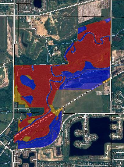
Depth to Water Table Macomb County, Michigan, and Oakland County, Michigan (River Bends Park, West Side, Shelby Twp.)
|
|
|
- Belinda Shepherd
- 6 years ago
- Views:
Transcription
1
2 () MAP LEGEND Area of Interest (AOI) Soils Soil Ratings Area of Interest (AOI) Soil Map Units > 200 Political Features Cities Water Features Transportation PLSS Township and Range PLSS Section Oceans Streams and Canals Rails Interstate Highways US Routes MAP INFORMATION Map Scale: 1:13,300 if printed on A size (8.5" 11") sheet. The soil surveys that comprise your AOI were mapped at scales ranging from 1:15,840 to 1:20,000. Please rely on the bar scale on each map sheet for accurate map measurements. Source of Map: URL: Coordinate System: UTM Zone 17N NAD83 This product is generated from the USDA-NRCS certified data as of the version date(s) listed below. Soil Survey Area: Macomb County, Survey Area Data: Version 5, Dec 14, 2006 Soil Survey Area: Oakland County, Survey Area Data: Version 7, Dec 14, 2009 Your area of interest (AOI) includes more than one soil survey area. These survey areas may have been mapped at different scales, with a different land use in mind, at different times, or at different levels of detail. This may result in map unit symbols, soil properties, and interpretations that do not completely agree across soil survey area boundaries. Date(s) aerial images were photographed: 7/30/2005 The orthophoto or other base map on which the soil lines were compiled and digitized probably differs from the background imagery displayed on these maps. As a result, some minor shifting of map unit boundaries may be evident. Major Roads Local Roads Page 2 of 5
3 Depth to Water Table Depth to Water Table Summary by Map Unit Macomb County, Map unit symbol Map unit name Rating (centimeters) Acres in AOI Percent of AOI BrA BrB BsA BsB BsC Boyer loamy sand, 0 to 2 percent Boyer loamy sand, 2 to 6 percent Boyer sandy loam, 0 to 2 percent Boyer sandy loam, 2 to 6 percent Boyer sandy loam, 6 to 12 percent BsE Boyer sandy loam, 18 to 25 percent > % > % > % > % > % > % Cf Ceresco fine sandy loam % Cm Cohoctah fine sandy loam % Gd Gilford sandy loam % Md Made land > % Pb Pits, borrow > % Pg Pits, gravel > % Sa Sanitary land fill > % Ta Tawas muck % Ur Urban land > % W Water > % WtA Wasepi sandy loam, 0 to 2 percent % Subtotals for Soil Survey Area % Totals for Area of Interest % Depth to Water Table Summary by Map Unit Oakland County, Map unit symbol Map unit name Rating (centimeters) Acres in AOI Percent of AOI 17A Wasepi sandy loam, 0 to 3 percent % 27 Houghton and Adrian mucks % 42 Pits > % 49 Cohoctah fine sandy loam % 68 Cohoctah-Fox association % Subtotals for Soil Survey Area % Totals for Area of Interest % Page 3 of 5
4 Description "Water table" refers to a saturated zone in the soil. It occurs during specified months. Estimates of the upper limit are based mainly on observations of the water table at selected sites and on evidence of a saturated zone, namely grayish colors (redoximorphic features) in the soil. A saturated zone that lasts for less than a month is not considered a water table. This attribute is actually recorded as three separate values in the database. A low value and a high value indicate the range of this attribute for the soil component. A "representative" value indicates the expected value of this attribute for the component. For this soil property, only the representative value is used. Rating Options Units of Measure: centimeters Aggregation Method: Dominant Component Aggregation is the process by which a set of component attribute values is reduced to a single value that represents the map unit as a whole. A map unit is typically composed of one or more "components". A component is either some type of soil or some nonsoil entity, e.g., rock outcrop. For the attribute being aggregated, the first step of the aggregation process is to derive one attribute value for each of a map unit's components. From this set of component attributes, the next step of the aggregation process derives a single value that represents the map unit as a whole. Once a single value for each map unit is derived, a thematic map for soil map units can be rendered. Aggregation must be done because, on any soil map, map units are delineated but components are not. For each of a map unit's components, a corresponding percent composition is recorded. A percent composition of 60 indicates that the corresponding component typically makes up approximately 60% of the map unit. Percent composition is a critical factor in some, but not all, aggregation methods. The aggregation method "Dominant Component" returns the attribute value associated with the component with the highest percent composition in the map unit. If more than one component shares the highest percent composition, the corresponding "tie-break" rule determines which value should be returned. The "tiebreak" rule indicates whether the lower or higher attribute value should be returned in the case of a percent composition tie. The result returned by this aggregation method may or may not represent the dominant condition throughout the map unit. Component Percent Cutoff: None Specified Components whose percent composition is below the cutoff value will not be considered. If no cutoff value is specified, all components in the database will be considered. The data for some contrasting soils of minor extent may not be in the database, and therefore are not considered. Tie-break Rule: Lower Page 4 of 5
5 The tie-break rule indicates which value should be selected from a set of multiple candidate values, or which value should be selected in the event of a percent composition tie. Interpret Nulls as Zero: No This option indicates if a null value for a component should be converted to zero before aggregation occurs. This will be done only if a map unit has at least one component where this value is not null. Beginning Month: January Ending Month: December Page 5 of 5
Suitability for Haul Roads (MI) Macomb County, Michigan, and Oakland County, Michigan (River Bends Park, West Side, Shelby Twp.)
 Macomb County, Michigan, and Oakland County, Michigan (River Bends Park, West Side, Shelby Twp.)") Suitability for Haul Roads (MI) Macomb, and Oakland () MAP LEGEND Area of Interest () Soils Soil Ratings Area of Interest () Soil Map Units Poorly suited Moderately suited Well suited Political Features
Suitability for Haul Roads (MI) Macomb, and Oakland () MAP LEGEND Area of Interest () Soils Soil Ratings Area of Interest () Soil Map Units Poorly suited Moderately suited Well suited Political Features
Erosion Hazard (Road, Trail) Angelina County, Texas (Upland Island Erosion Hazard (Road, Trail)) Web Soil Survey National Cooperative Soil Survey
 Angelina County, Texas (Upland Island Erosion Hazard (Road, Trail)) Web Soil Survey National Cooperative Soil Survey") Cypress Creek Erosion Hazard (Road, Trail) Angelina County, Texas () 31 7' 50'' 31 4' 50'' 3439500 3440400 3441300 3442200 3443100 3444000 3444900 94 24' 48'' 94 24' 51'' 365700 Graham Creek 365700 366600
Cypress Creek Erosion Hazard (Road, Trail) Angelina County, Texas () 31 7' 50'' 31 4' 50'' 3439500 3440400 3441300 3442200 3443100 3444000 3444900 94 24' 48'' 94 24' 51'' 365700 Graham Creek 365700 366600
Erosion Hazard (Off-Road, Off-Trail) Angelina County, Texas (Upland Island Erosion Hazard (Off-Road, Off-Trail))
 Angelina County, Texas (Upland Island Erosion Hazard (Off-Road, Off-Trail))") Cypress Creek Erosion Hazard (Off-Road, Off-Trail) Angelina County, Texas () 31 7' 50'' 31 4' 50'' 3439500 3440400 3441300 3442200 3443100 3444000 3444900 94 24' 48'' 94 24' 51'' 365700 Graham Creek 365700
Cypress Creek Erosion Hazard (Off-Road, Off-Trail) Angelina County, Texas () 31 7' 50'' 31 4' 50'' 3439500 3440400 3441300 3442200 3443100 3444000 3444900 94 24' 48'' 94 24' 51'' 365700 Graham Creek 365700
APPENDIX C - NRCS PRIME FARMLAND REPORT
 APPENDIX C - NRCS PRIME FARMLAND REPORT June 2007 Page 51 Parks, Trails, and Open Space Plan Page 52 Payson City- East Side Comprehensive Plan FARMLAND CLASSIFICATION RATING FOR UTAH COUNTY, UTAH - CENTRAL
L I N D E M A N N. Young Almonds Excellent Production Potential Madera County Acres P R O P E R T I E S I N C.
 L I N D E M A N N Young Almonds Excellent Production Potential Madera County 19.11+- Acres P R O P E R T I E S I N C. 3734 W. Spruce Ave Fresno, CA 93711 TEL-559-479-1658 FAX-559-827-4077 Young Almonds
Custom Soil Resource Report for Ramsey County, North Dakota
 United States Department of Agriculture Natural Resources Conservation Service A product of the National Cooperative Soil Survey, a joint effort of the United States Department of Agriculture and other
Applying GIS to Determine Suitability for Viticulture in Washington State. 1. Introduction Data Collection... 8
 Gockowski 1 Mark Gockowski Dr. David Maidment CE394K.3 GIS in Water Resources 12/2/2016 Applying GIS to Determine Suitability for Viticulture in Washington State Contents 1. Introduction... 4 1.1 Background...
Cactus Moth Detection & Monitoring Network
 Cactus Moth Detection & Monitoring Network Pricklypear Data Form Variable Definitions Pricklypear Data Form Pricklypear in the context of this form refers to pad-forming Opuntia spp. belonging to the subgenus
 72C 155F 350B 350C 542A SOILS IN AREA OF INTEREST Doughty Loam; 4 to 8 percent slopes Anceney Cobbly Loam; 15 to 60 percent slopes Blackmore Silt Loam; 0 to 4 percent slopes Blackmore Silt Loam; 4 to 8
I-20 at Hwy-277 Northeast Richland County, SC
 Springtree Apartments Greenbriar Apartments 277 For Sale ±21.07 Acres I-20 at Hwy-277 Northeast Richland County, SC Property Features ±21.07 acres available Unincorporated Richland County Excellent visibility
Custom Soil Resource Report for Dawes County, Nebraska
 United States Department of Agriculture Natural Resources Conservation Service A product of the National Cooperative Soil Survey, a joint effort of the United States Department of Agriculture and other
Custom Soil Resource Report for Wright County, Minnesota
 United States Department of Agriculture Natural Resources Conservation Service A product of the National Cooperative Soil Survey, a joint effort of the United States Department of Agriculture and other
SPATIAL ANALYSIS OF WINERY CONTAMINATION
 SPATIAL ANALYSIS OF WINERY CONTAMINATION The Spatial Analysis of Winery Contamination project used a previously created MS Access database to create a personal geodatabase within ArcGIS in order to perform
Dreher Shoals Irmo, South Carolina
 For Sale ±1346 Acres Dreher Shoals Irmo, South Carolina Dutch Fork Road Property Features Exxon Subway/ Burger King Wildlife Solutions Walgreens Our Hands Together Dutch Fork Baptist Church Dreher Shoals
Custom Soil Resource Report for Warren County, Kentucky
 United States Department of Agriculture Natural Resources Conservation Service A product of the National Cooperative Soil Survey, a joint effort of the United States Department of Agriculture and other
NZ GEOGRAPHICAL INDICATION (GI)
") NZ GEOGRAPHICAL INDICATION (GI) EXAMINATION CHECKSHEET Application information (reg 7) and formalities Box Reference Number 1 GI Number: 1021 GI Name: MATAKANA 2 New Zealand GI correctly selected (cf foreign)
NZ GEOGRAPHICAL INDICATION (GI) EXAMINATION CHECKSHEET Application information (reg 7) and formalities Box Reference Number 1 GI Number: 1021 GI Name: MATAKANA 2 New Zealand GI correctly selected (cf foreign)
$49,000,000. TULARE 22 Pistachios. 1,509.21± acres. Exclusively Presented by: Tulare County, CA. ($32,468 per acre)
") TULARE 22 $49,000,000 ($32,468 per acre) Exclusively Presented by: CA BRE# 00020875 www.pearsonrealty.com TULARE 22 Location The property is located East of Highway approximately 5 miles northwest of the
TULARE 22 $49,000,000 ($32,468 per acre) Exclusively Presented by: CA BRE# 00020875 www.pearsonrealty.com TULARE 22 Location The property is located East of Highway approximately 5 miles northwest of the
Custom Soil Resource Report for Polk and San Jacinto Counties, Texas
 United States Department of Agriculture Natural Resources Conservation Service A product of the National Cooperative Soil Survey, a joint effort of the United States Department of Agriculture and other
GLOSSARY Last Updated: 10/17/ KL. Terms and Definitions
 GLOSSARY Last Updated: 10/17/2017 - KL Terms and Definitions Spacing 4ETa Zone(s) Background Drill Elevation Climate Soil Ecoregion 4 Recommended base spacing between containerized, cutting, plug or sprig
$44,000,000. TULARE 22 Pistachios. 1,506.25± acres. E xclus iv ely Pr esen t e d by : ($29,212 per acre) CA BRE#
 CA BRE#") TULARE 22 E xclus iv ely Pr esen t e d by : Tu l a r e C o u n t y, C A $44,000,000 ($29,212 per acre) CA BRE# 00020875 www.pearsonrealty.com TULARE 22 Tu l a r e C o u n t y, C A Lo c at i on The property
TULARE 22 E xclus iv ely Pr esen t e d by : Tu l a r e C o u n t y, C A $44,000,000 ($29,212 per acre) CA BRE# 00020875 www.pearsonrealty.com TULARE 22 Tu l a r e C o u n t y, C A Lo c at i on The property
FOR SALE VINEYARD AND OPEN LAND ACRES WALLACE ROAD KERN COUNTY CA
 VINEYARD AND OPEN LAND FOR SALE WALLACE ROAD KERN COUNTY CA PROPERTY HIGHLIGHTS Southern San Joaquin Municpal Utility District Deep well Existing table grape and wine grape vineyard Additional open land
NZ GEOGRAPHICAL INDICATION (GI)
") NZ GEOGRAPHICAL INDICATION (GI) EXAMINATION CHECKSHEET Application information (reg 7) and formalities Box Reference Number 1 GI Number: 1015 GI Name: WAIHEKE ISLAND 2 New Zealand GI correctly selected
NZ GEOGRAPHICAL INDICATION (GI) EXAMINATION CHECKSHEET Application information (reg 7) and formalities Box Reference Number 1 GI Number: 1015 GI Name: WAIHEKE ISLAND 2 New Zealand GI correctly selected
Adelaide Plains Wine Region
 SA Winegrape Crush Survey Regional Summary Report 2017 Adelaide Plains Wine Region Adelaide Plains Vintage overview OVERVIEW OF VINTAGE STATISTICS A total of 3,496 tonnes of Adelaide Plains winegrapes
Farmland Auction Wednesday, November 14, 10 AM Marion Columbus Club 5650 Kacena Ave, Marion, Iowa
 Linn County, IA 122 Acres M/L Sold for $1,793,400 $14,700/Acre Farmland Auction Wednesday, November 14, 10 AM Marion Columbus Club 5650 Kacena Ave, Marion, Iowa 13 County Home Road County Home Road 13
Fleurieu zone (other)
") Fleurieu zone (other) Incorporating Southern Fleurieu and Kangaroo Island wine regions, as well as the remainder of the Fleurieu zone outside all GI regions Regional summary report 2006 South Australian
Fleurieu zone (other) Incorporating Southern Fleurieu and Kangaroo Island wine regions, as well as the remainder of the Fleurieu zone outside all GI regions Regional summary report 2006 South Australian
PROPERTY DESCRIPTION PROPOSED CONSTRUCTION
 September 30, 2010 Project No. 10797 11A Ms. Ginger Hitzke Hitzke Development Corporation 251 Autumn Drive, Suite 100 San Marcos, CA 92069 Subject: Interpretive Report for Infiltration System Design, Proposed
SA Winegrape Crush Survey Regional Summary Report 2017 South Australia - other
 SA Winegrape Crush Survey Regional Summary Report 2017 South Australia - other Vintage overview South Australia (other) includes the GI region of Southern Flinders Ranges, the Peninsulas zone, and the
Adelaide Hills Wine Region
 SA Winegrape Crush Survey Regional Summary Report 2017 Adelaide Hills Wine Region Adelaide Hills Vintage overview VINTAGE REPORT The annual rainfall in 2016 (1240mm at Lenswood) was the highest in the
Langhorne Creek Wine Region
 SA Winegrape Crush Survey Regional Summary Report 2017 Langhorne Creek Wine Region Vintage overview VINTAGE REPORT The Langhorne Creek wine region experienced a long, slow vintage in 2017, beginning with
Goodban Ecological Consulting Inc.
 Goodban Ecological Consulting Inc. 879 Cabot Trail, Milton, Ontario L9T 3W4 Phone: (905) 693-9064 e-mail: anthony.goodban@sympatico.ca January 30, 2013 Ms. Melinda Thompson-Black: Species at Risk Biologist
Custom Soil Resource Report for Lamoille County, Vermont
 United States Department of Agriculture Natural Resources Conservation Service A product of the National Cooperative Soil Survey, a joint effort of the United States Department of Agriculture and other
[Billing Code: P] [Docket No. TTB ; T.D. TTB 148; Re: Notice No. 162] AGENCY: Alcohol and Tobacco Tax and Trade Bureau, Treasury.
![[Billing Code: P] [Docket No. TTB ; T.D. TTB 148; Re: Notice No. 162] AGENCY: Alcohol and Tobacco Tax and Trade Bureau, Treasury.](/thumbs/81/83414830.jpg "[Billing Code: P] [Docket No. TTB ; T.D. TTB 148; Re: Notice No. 162] AGENCY: Alcohol and Tobacco Tax and Trade Bureau, Treasury.") This document is scheduled to be published in the Federal Register on 12/07/2017 and available online at https://federalregister.gov/d/2017-26414, and on FDsys.gov [Billing Code: 4810 31 P] DEPARTMENT
This document is scheduled to be published in the Federal Register on 12/07/2017 and available online at https://federalregister.gov/d/2017-26414, and on FDsys.gov [Billing Code: 4810 31 P] DEPARTMENT
#611 ON-SITE TESTING AND EVALUATION
 OBJECTIVES: After completing this chapter, you will be able to... Discuss the purpose of a percolation test. List the regulatory requirements for conducting a percolation test. Revised 01-02-2013 MEETING
2012 Estimated Acres Producers Estimated Production Units Estimated Farm Value Farm Crawfish 182,167 1,251 90,973,725 Lbs.
 www.lsuagcenter.com 2012 Estimated Acres Producers Estimated Production Units Estimated Farm Value Farm Crawfish 182,167 1,251 90,973,725 Lbs. $152,835,858 Crawfish Biology Life Cycles evolved in nature,
Increasing the efficiency of forecasting winegrape yield by using information on spatial variability to select sample sites
 Increasing the efficiency of forecasting winegrape yield by using information on spatial variability to select sample sites Andrew Hall, Research Fellow, Spatial Science Leo Quirk, Viticulture Extension
TABLE OF CONTENTS. Page. Page
 TABLE OF CONTENTS Chapter 1 INTRODUCTION... 1-1 Background... 1-1 Planning Benefits... 1-1 Comprehensive Planning Law... 1-4 County Partnership... 1-5 Advisory Committee and Staff Structure... 1-5 Plan
Food and Physical Activity Deserts in Cincinnati: Myths and Realties
 Food and Physical Activity Deserts in Cincinnati: Myths and Realties Dr. Chris Auffrey Mr. Sagar Shah School of Planning University of Cincinnati Data! Fostering Health Information in Kentucky and Ohio
food and drink Nutritionists advise us to eat at least 5 fruit or vegetable portions a day. What does a portion look like?
 How much does a pea weigh? Nutritionists advise us to eat at least 5 fruit or vegetable portions a day. Estimate the weights of some fruit or vegetables. Record your estimates before weighing the items.
Break down K cups. Faculty collection
 DATA: Data Table 1 Daily Activity Log A summary of student activities completed each school day for the composting program over a period of 26 days. items were activities that were not repeated. The number
PROPERTY INFORMATION SUMMARY. 599 Testalinden Place, 4.5 miles South of Oliver BC. Legal Description Size Property Description
 PROPERTY INFORMATION SUMMARY 599 Testalinden Place, 4.5 miles South of Oliver BC Legal Description Size Property Description Lot A, District Lot 2450s, Similkameen Division Yale District, Plan EPP25799
Coffee zone updating: contribution to the Agricultural Sector
 1 Coffee zone updating: contribution to the Agricultural Sector Author¹: GEOG. Graciela Romero Martinez Authors²: José Antonio Guzmán Mailing address: 131-3009, Santa Barbara of Heredia Email address:
SA Winegrape Crush Survey Regional Summary Report Barossa Valley Wine Region (including Barossa Zone - other)
") SA Winegrape Crush Survey Regional Summary Report 2016 Barossa Valley Wine Region (including Barossa Zone - other) Explanations and Definitions INTAKE (CURRENT VINTAGE) DATA Definition of regions Regions
SA Winegrape Crush Survey Regional Summary Report 2016 Barossa Valley Wine Region (including Barossa Zone - other) Explanations and Definitions INTAKE (CURRENT VINTAGE) DATA Definition of regions Regions
McLaren Vale Wine Region
 SA Winegrape Crush Survey Regional Summary Report 2017 McLaren Vale Wine Region Vintage overview VINTAGE REPORT Vintage 2017 in the McLaren Vale Wine Region was judged highly successful for both grape
VINEYARD NUTRIENTS AT BROOKWOOD ESTATE MARGARET RIVER, WESTERN AUSTRALIA
 CASE STUDY VINEYARD NUTRIENTS AT BROOKWOOD ESTATE MARGARET RIVER, WESTERN AUSTRALIA T3 SGS 1086 - CS52 ISSUED AUGUST 2012 A.W. MANN INTRODUCTION Ten essential nutrients can be analyzed on the ICP-MS after
Silage Corn Variety Trial in Central Arizona
 Silage Corn Variety Trial in Central Arizona Jay Subramani 1 and Shawna Loper 2 1 Maricopa Ag Center, University of Arizona 2 University of Arizona Cooperative Extension, Pinal County Abstract Information
Clare Valley Wine Region
 SA Winegrape Crush Survey Regional Summary Report 2017 Clare Valley Wine Region Vintage overview VINTAGE REPORT The vintage kicked off in the last week in February in the early subregions and in earnest
Geographic Information Systemystem
 Agenda Time 9:00:-9:20 9-20 9:50 9:50 10:00 Topic Intro to GIS/Mapping and GPS Applications for GIS in Vineyards Break Presenter Kelly Bobbitt, Mike Bobbitt and Associates Kelly Bobbitt, Mike Bobbitt and
How Rest Area Commercialization Will Devastate the Economic Contributions of Interstate Businesses. Acknowledgements
 How Rest Area Commercialization Will Devastate the Economic Contributions of Interstate Businesses Acknowledgements The NATSO Foundation, a charitable 501(c)(3) organization, is the research and educational
Research - Strawberry Nutrition
 Research - Strawberry Nutrition The Effect of Increased Nitrogen and Potassium Levels within the Sap of Strawberry Leaf Petioles on Overall Yield and Quality of Strawberry Fruit as Affected by Justification:
City and County of San Francisco DEPARTMENT OF PUBLIC HEALTH ENVIRONMENTAL HEALTH
 City and County of San Francisco DEPARTMENT OF PUBLIC HEALTH ENVIRONMENTAL HEALTH London N. Breed, Mayor Barbara A. Garcia, MPA, Director of Health Stephanie K. J. Cushing, MSPH, CHMM, REHS Director of
OF THE VARIOUS DECIDUOUS and
 (9) PLAXICO, JAMES S. 1955. PROBLEMS OF FACTOR-PRODUCT AGGRE- GATION IN COBB-DOUGLAS VALUE PRODUCTIVITY ANALYSIS. JOUR. FARM ECON. 37: 644-675, ILLUS. (10) SCHICKELE, RAINER. 1941. EFFECT OF TENURE SYSTEMS
3250 Bennett Lane, Calistoga
 3250 Bennett Lane, Calistoga 3250 Bennett Lane, Calistoga price upon request For further information please contact: Paul Spitler V&E Properties Direct:707.480.7882 plndmn@earthlink.net dre#: 00846225
3250 Bennett Lane, Calistoga
 3250 Bennett Lane, Calistoga 3250 Bennett Lane, Calistoga price upon request For further information please contact: Paul Spitler V&E Properties Direct:707.480.7882 plndmn@earthlink.net dre#: 00846225
Bt Corn IRM Compliance in Canada
 Bt Corn IRM Compliance in Canada Canadian Corn Pest Coalition Report Author: Greg Dunlop (BSc. Agr, MBA, CMRP), ifusion Research Ltd. 15 CONTENTS CONTENTS... 2 EXECUTIVE SUMMARY... 4 BT CORN MARKET OVERVIEW...
Carex kobomugi (Japanese sedge Asiatic sand sedge )
") 1 of 6 9/24/2007 3:33 PM Home Early Detection IPANE Species Data & Maps Volunteers About the Project Related Information Catalog of Species Search Results :: Catalog of Species Search Carex kobomugi (Japanese
1 of 6 9/24/2007 3:33 PM Home Early Detection IPANE Species Data & Maps Volunteers About the Project Related Information Catalog of Species Search Results :: Catalog of Species Search Carex kobomugi (Japanese
US FOODS E-COMMERCE AND TECHNOLOGY OFFERINGS
 US FOODS MOBILE EASY ONLINE ORDER US FOODS E-COMMERCE AND TECHNOLOGY OFFERINGS PERSONALIZED CONTENT WE HELP MAKE IT EASY TO ORDER ONLINE One platform. Integrated solutions. Complete control. US Foods e-commerce
#611-7 Workbook REVIEW OF PERCOLATION TESTING PROCEDURES. After completing this chapter, you will be able to...
 REVIEW OF PERCOLATION 7 TESTING PROCEDURES CHAPTER OBJECTIVES: After completing this chapter, you will be able to... Discuss the purpose of a percolation test. List the regulatory requirements for conducting
FOR PERSONAL USE. Capacity BROWARD COUNTY ELEMENTARY SCIENCE BENCHMARK PLAN ACTIVITY ASSESSMENT OPPORTUNITIES. Grade 3 Quarter 1 Activity 2
 activity 2 Capacity BROWARD COUNTY ELEMENTARY SCIENCE BENCHMARK PLAN Grade 3 Quarter 1 Activity 2 SC.A.1.2.1 The student determines that the properties of materials (e.g., density and volume) can be compared
Silage Corn Variety Trial in Central Arizona
 Silage Corn Variety Trial in Central Arizona Shawna Loper 1 and Jay Subramani 2 1 University of Arizona of Arizona Cooperative Extension, Pinal County 2 Maricopa Ag Center, University of Arizona Abstract
Guidelines for measuring the area of vineyard parcels in the context of Regulations (EC) No 479/2008 and 555/2008
 No 479/2008 and 555/2008") EUROPEAN COMMISSION JOINT RESEARCH CENTRE Institute for the Protection and Security of the Citizen Agriculture Unit JRC IPSC/G03/P/KGA/kga D(2008)(9675) / file://s:\fmparchive\p\9675.doc Working Document
EUROPEAN COMMISSION JOINT RESEARCH CENTRE Institute for the Protection and Security of the Citizen Agriculture Unit JRC IPSC/G03/P/KGA/kga D(2008)(9675) / file://s:\fmparchive\p\9675.doc Working Document
Joseph G. Alfieri 1, William P. Kustas 1, John H. Prueger 2, Lynn G. McKee 1, Feng Gao 1 Lawrence E. Hipps 3, Sebastian Los 3
 Joseph G. Alfieri 1, William P. Kustas 1, John H. Prueger 2, Lynn G. McKee 1, Feng Gao 1 Lawrence E. Hipps 3, Sebastian Los 3 1 USDA, ARS, Hydrology & Remote Sensing Lab, Beltsville MD 2 USDA,ARS, National
Applied Geomatics--connecting the dots between grapevine physiology,
 Applied Geomatics--connecting the dots between grapevine physiology, terroir, and remote sensing Andrew Reynolds, Brock University Ralph Brown, University of Guelph Matthieu Marciniak; David Ledderhoff;
Washington State Wine 101
 Washington State Wine 101 Washington 2 nd Largest Producer in US Washington State produces: Premium wines of superior quality Range of varieties Distinctive character Unique balance of Old World and New
School Breakfast and Lunch Program Request for Proposal
 School Breakfast and Lunch Program Provident Charter School 1400 Troy Hill Road Pittsburgh, PA 15212 412-709-5160 Date Proposal Opens: Wednesday, July 12, 2017 @ 12pm Bid Due Date: Wednesday, July 26,
The New Products People Want to Buy... And Why
 The New Products People Want to Buy... And Why Plant-Based Products JANUARY 2017 What we saw this week According to Mintel s 2017 Food and Drink trend Power to the Plants, the preference for natural, simple
Supplement of Physical and chemical properties of deposited airborne particulates over the Arabian Red Sea coastal plain
 Supplement of Atmos. Chem. Phys., 17, 11467 11490, 2017 https://doi.org/10.5194/acp-17-11467-2017-supplement Author(s) 2017. This work is distributed under the Creative Commons Attribution 3.0 License.
Soybean Yield Loss Due to Hail Damage*
 1 of 6 6/11/2009 9:22 AM G85-762-A Soybean Yield Loss Due to Hail Damage* This NebGuide discusses the methods used by the hail insurance industry to assess yield loss due to hail damage in soybeans. C.
Assignment 03 Portfolio
 Assignment 03 Portfolio The portfolio will be the examination opportunity for Module GGH2603. Plagiarism will not be tolerated. If it is found that you copied from another source, website, article, textbook,
Vineyard Site Evaluation For: Beringer
 For: Location: 32720 SW Bell Rd, Sherwood OR 97140 T3S R2W Sec 11 Total Property Acreage: TL200 (39.7 acres), TL300 (19.84 acres), TL301 (59.99 acres) Gross Plantable Vineyard Acres (approximate): 90.0
SPECTACULAR ESTATE VINEYARD AND WINERY SITE ASTI ROAD CLOVERDALE, CALIFORNIA $3,850, Total Acres
 SPECTACULAR ESTATE VINEYARD AND WINERY SITE 24480 ASTI ROAD CLOVERDALE, CALIFORNIA $3,850,000 65.6 Total Acres 33.3± Acres Mostly Hillside Planted Vineyard, Cabernet Sauvignon, Zinfandel, Hillside Building
Fact Sheet VITICULTURE
 Assessing soil health in a vineyard Fact Sheet Introduction As grape and wine producers become more concerned about the long-term sustainability of their vineyards and winemaking businesses, an interest
A Hedonic Analysis of Retail Italian Vinegars. Summary. The Model. Vinegar. Methodology. Survey. Results. Concluding remarks.
 Vineyard Data Quantification Society "Economists at the service of Wine & Vine" Enometrics XX A Hedonic Analysis of Retail Italian Vinegars Luigi Galletto, Luca Rossetto Research Center for Viticulture
Memorandum for Tree Survey at the Marywood Residential Development Site in Orange, CA.
 Memorandum Date: January 22, 2015 To: From: Subject: The New Home Company Brianna Bernard, VCS Environmental Memorandum for Tree Survey at the Marywood Residential Development Site in Orange, CA. 1. Introduction
2016 STATUS SUMMARY VINEYARDS AND WINERIES OF MINNESOTA
 IN PARTNERSHIP WITH THE NORTHERN GRAPES PROJECT, AN USDA SPECIALITY CROPS RESEARCH INITIATIVE PROGRAM, NIFA 2016 STATUS SUMMARY VINEYARDS AND WINERIES OF MINNESOTA Brigid Tuck and William Gartner INTRODUCTION
QUALITY DESCRIPTOR / REPRESENTATIONS GUIDELINES FOR THE
 QUALITY DESCRIPTOR / REPRESENTATIONS GUIDELINES FOR THE AUSTRALIAN FRUIT JUICE INDUSTRY Adopted 30 September 2005 Reviewed 12 January 2007 CODE OF PRACTICE QUALITY DESCRIPTOR/REPRESENTATIONS GUIDELINES
VIÑA AMBROSIA TERROIR REPORT Ph.D Pedro PARRA SEPT 2013
 VIÑA AMBROSIA TERROIR REPORT Ph.D Pedro PARRA SEPT 2013 1- INTRODUCCION A terroir prospection was made for the Ambrosia property during 2012-2013. The observations where made in 4 different fieldwork days.
Route List Setup. About Route List Setup
 This chapter provides information to add or delete route lists or to add, remove, or change the order of route groups in a route list. For additional information about route plans, see the Cisco Unified
What is Saffron? Saffron is the dry stigma of Crocus sativus L. flowers. Flowering: autumn. In cultivation for over 3,500 yr
 What is Saffron? The most expensive spice in the world over $3,000-9,000/lb! Saffron is the dry stigma of Crocus sativus L. flowers. Flowering: autumn In cultivation for over 3,500 yr Origin: Probably
UTZ Tea Statistics Report 2017
 UTZ Tea Statistics Report 2017 More than 107,000 tea farmers and workers benefit from the UTZ program UTZ certified tea is produced in 13 countries In 2017, more than 4.6 billion cups of UTZ certified
Wine Tourism Regions APPLICATION FORM. Ref:
 APPLICATION FORM Ref: 160909 Wine Tourism Regions 1. Background Tourist Signs in NSW Tourist signs in Australia have a white legend on a brown background and are installed to assist road users in locating
National Apple Orchards Census 2007
 National Apple Orchards Census 2007 1 Table of Contents Introduction Page i Executive Summary Page ii Section 1 Orchard Area, Sales, Growers and Markets Page 1 Section 2 Varieties and Orchard Age Page
CITRUS PRELIMINARY REPORT
 COMMERCIAL CITRUS INVENTORY CITRUS PRELIMINARY REPORT Cooperating with the Florida Department of Agriculture & Consumer Services 1222 Woodward St. Orlando, FL 32803 (407) 648-6013 (407) 648-6029 FAX www.nass.usda.gov/fl
RDA Training Booklet -- Veve (Upd 03/2014)
") University of North Florida UNF Digital Commons Library Faculty Presentations & Publications Thomas G. Carpenter Library 3-17-2014 RDA Training Booklet -- Veve (Upd 03/2014) Marielle Veve University of
University of North Florida UNF Digital Commons Library Faculty Presentations & Publications Thomas G. Carpenter Library 3-17-2014 RDA Training Booklet -- Veve (Upd 03/2014) Marielle Veve University of
Work Sample. Morgan. Identifies some characteristics of target market. Product Planning. Identify the characteristics of your target market
 Product Planning Identify the characteristics of your target market My target market is aimed at women aged 15 and over who have a busy lifestyle either living in Newtown or travelling through Newtown
Bags not: avoiding the undesirable Laurie and Winifred Bauer
 Bags not: avoiding the undesirable Laurie and Winifred Bauer Question 10 asked how children claim the right not to do something: 10 Your class is waiting for the bus to arrive to take you on a trip. You
Jackson Ranch. Proposed 207± ac Mixed Use Highway Commercial Development. SWC Interstate 5 & Utica Ave in Kings County, CA
 Jackson Ranch Proposed 207± ac Mixed Use Highway Commercial Development Rachael Orlando 559.447.6252 rachael@retailcalifornia.com DRE # 01890236 SWC Interstate 5 & Utica Ave in Kings County, CA For additional
Veganuary Month Survey Results
 Veganuary 2016 6-Month Survey Results Project Background Veganuary is a global campaign that encourages people to try eating a vegan diet for the month of January. Following Veganuary 2016, Faunalytics
Napa County Planning Commission Board Agenda Letter
 Agenda Date: 3/4/2015 Agenda Placement: 10A Napa County Planning Commission Board Agenda Letter TO: FROM: Napa County Planning Commission David Morrison - Director Planning, Building and Environmental
A C E. Answers Investigation 1. Review Day: 1/5 pg. 22 #10, 11, 36, 37, 38
 A C E Answers Investigation 1 Review Day: 1/5 pg. 22 #10, 11, 3, 37, 38 10. a. Mix Y is the most appley given it has the highest concentrate- to- juice ratio. The ratios of concentrate to juice are the
EXECUTIVE SUMMARY. 1. When do Asian clams reproduce in Lake George? 2. How fast do Asian clams grow in Lake George?
 Reproduction and Growth of Asian Clams in Lake George Report to the Lake George Association 3-21-16 Sandra Nierzwicki-Bauer, Jeremy Farrell Darrin Fresh Water Institute EXECUTIVE SUMMARY Asian clams have
G Soybean Yield Loss Due to Hail Damage
 Extension Historical Materials from University of Nebraska-Lincoln Extension University of Nebraska Lincoln Year 1985 G85-762 Soybean Yield Loss Due to Hail Damage Charles A. Shapiro T.A. Peterson A.D.
Growth of baleen of a rehabilitating gray whale calf
 Aquatic Mammals 2001, 27.3, 234 238 Growth of baleen of a rehabilitating gray whale calf J. L. Sumich Department of Biological Sciences, Grossmont College, El Cajon, CA 92020, USA Abstract The pattern
EXPLORING THE OPTIMIZATION MODEL OF VIETNAMESE CONSUMERS FOR STERILIZED MILKS
 EXPLORING THE OPTIMIZATION MODEL OF VIETNAMESE CONSUMERS FOR STERILIZED MILKS THANH BA Nguyen* a,b, MINH TAM Le, c and DZUNG HOANG NGUYEN b a HoChiMinh City University of Technology, Hochiminh-city (HCMUT)
Exhibit 2.1 Tree Nuts Included in Specialty Crop Definition Almond Cashew Chestnut Hazelnut Macadamia Pecan Pistachio Walnut
 2. Tree Nuts The specialty crop definition from the USDA Agricultural Marketing Service names eight tree nuts that are considered specialty crops. Exhibit 2.1 lists these tree nut species. Of these tree
Ridge. 137 Lot Entitled Subdivision in the City of Plymouth, California Website & Video: Listed at $2,950,000
 Shenandoah Ridge 147 Acres in the Shenandoah Valley Wine Region 137 Lot Entitled Subdivision in the City of Plymouth, California 95669 Website & Video: www.shenandoahplymouth.com Listed at $2,950,000 Prepared
Name Class Date. Down 1. The Maya built these buildings to. 2. The Aztec leader killed by the. 4. He and his troops conquered the
 Name Class Date The Early Americas BIG IDEAS 1. The Maya developed a civilization that thrived in Mesoamerica from about 250 until the 900s. 2. The strong Aztec Empire, founded in central Mexico in 1325,
Route List Configuration
 CHAPTER 32 Use the following topics to add or delete route lists or to add, remove, or change the order of route groups in a route list: Settings, page 32-1 Adding Route Groups to a Route List, page 32-3
Starbucks Geography Summary
 Lesson Plans Starbucks Geography Starbucks Geography Summary Overview There are five lessons designed to teach basic geographic concepts. Each lesson uses Starbucks Coffee to help illustrate the main concepts.
IT 403 Project Beer Advocate Analysis
 1. Exploratory Data Analysis (EDA) IT 403 Project Beer Advocate Analysis Beer Advocate is a membership-based reviews website where members rank different beers based on a wide number of categories. The
THE ECONOMIC IMPACT OF BEER TOURISM IN KENT COUNTY, MICHIGAN
 THE ECONOMIC IMPACT OF BEER TOURISM IN KENT COUNTY, MICHIGAN Dan Giedeman, Ph.D., Paul Isely, Ph.D., and Gerry Simons, Ph.D. 10/8/2015 THE ECONOMIC IMPACT OF BEER TOURISM IN KENT COUNTY, MICHIGAN EXECUTIVE